Maps
to
764
906
66
973
10
3
2,926
2,181
476
3
289
34
10
127
7
35
9
2
5
3
4
2
968
11
9
4
2
91
43
29
17
14
973
973
973
63
12
11
10
6
Maps For Sale
Period: 1970s
Period: 17th Century
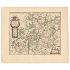
Circa 1659 Blaeu Family Map: Glogau and the Odra River Valley, Silesia
Located in Langweer, NL
Circa 1659 Blaeu Family Map: Glogau and the Odra River Valley, Silesia
This hand-colored map from circa 1659 by the Blaeu Family, titled "Ducatus Silesiae Glogani Vera Delineatio," provides a detailed view of the Odra River valley in western Poland, centered around the city of Glogau.
The map, based on the work of Silesian cartographer Jonas Scultetus, is oriented with north to the left. It intricately details forests, rivers, lakes, and numerous small villages.
A large decorative title cartouche features an ornate coat of arms and a key to the map's symbols. The bottom right includes a finely crafted scale of miles cartouche, adorned with calipers and a pair of falcons.
Published between 1659 and 1672, the map has Spanish text on the verso.
Measuring 19.9 inches wide by 16.4 inches high, it is in good condition with full contemporary color on a bright sheet, a watermark of the god Atlas, some marginal soiling, and a few short tears along the edges.
Keywords:
- Blaeu Family map
- Silesia historical map
- Glogau map
- Odra River valley
- 17th-century Poland map
- Jonas Scultetus
- Decorative cartouches
- Historical cartography
- Antique maps of Poland...
Category
1650s Antique Maps
Materials
Paper
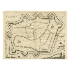
Antique Map of the City of Leeuwarden by Priorato, 1673
Located in Langweer, NL
Antique map titled 'Leverden'. This map depicts the city of Leeuwarden (Friesland, The Netherlands). This original antique print originates from 'Teatro del Belgio (…)', published in...
Category
17th Century Antique Maps
Materials
Paper
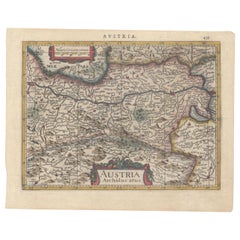
1634 Mercator/Jansson Map: Eastern Austria with Vienna, Hand-Colored
Located in Langweer, NL
1634 Mercator/Jansson Map: Eastern Austria with Vienna, Hand-Colored
This hand-colored map from 1634, titled "Austria Archiducatus," by Mercator and Jansson, depicts the eastern reg...
Category
1630s Antique Maps
Materials
Paper
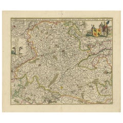
Antique Map of the Hainaut Region 'France' by F. de Wit, circa 1680
Located in Langweer, NL
Antique map titled 'Comitatus Hannoniae et Episcopatus Cambresis Descriptio'. Large map of the Hainaut region, France. Published by F. de Wit, circa 1680.
Category
Late 17th Century Antique Maps
Materials
Paper
Antique Map of the Iberian Peninsula with two decorative Cartouches
Located in Langweer, NL
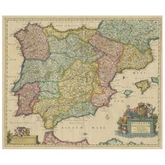
Antique map titled 'Hispaniae et Portugalliae Regna'. Original old map of the Iberian peninsula showing Spain, Portugal and the Balearic Islands. Two beautiful cartouches with severa...
Category
Late 17th Century Antique Maps
Materials
Paper
Framed Mercator Hondius Hispania Nova Atlas Minor Map
Located in Stamford, CT
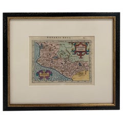
Framed colored example of this decorative and important minature map. Newly framed in brown wood frame with gold trim.
Mercator Hondius “Atlas Minor” pu...
Category
17th Century Dutch Spanish Colonial Antique Maps
Materials
Glass, Wood, Paper
Antique Print of Chinese Vessels Near Lantam, China, 1665
Located in Langweer, NL
Antique print titled 'Lantam'. Old print depicting Chinese ships on the coast of Lantam. Also depicted are Chinese village houses. This print originates f...
Category
17th Century Antique Maps
Materials
Paper
1698 Mercator Ptolemaic Map of Asia East of the Ganges
Located in Langweer, NL
**Catalogue Description:**
**Title:** Tab. XI. Asiae, comprehendens Indiam extra Gangem.
**Description:**
This is an exquisite Ptolemaic map depicting Asia east of the Ganges, ti...
Category
1680s Antique Maps
Materials
Paper
Bird’s-Eye View Map of Gallipoli: Fortified Ionian Gem by Mattheus Merian, 1688
Located in Langweer, NL
Bird’s-Eye View Map of Gallipoli: Fortified Ionian Gem by Mattheus Merian
Description:
This exquisitely detailed map of Gallipoli, crafted by the renowned engraver Mattheus Merian,...
Category
1680s Antique Maps
Materials
Paper
Gallipoli Fortifications: A 1688 Engraved Bird’s-Eye Map by Mattheus Merian
Located in Langweer, NL
Gallipoli Fortifications: A 1688 Bird’s-Eye Map by Mattheus Merian
Description: This exquisitely detailed map of Gallipoli, crafted by the renowned engraver Mattheus Merian, offers ...
Category
1680s Antique Maps
Materials
Paper
Antique Map of the City of Zwolle by Guicciardini, 1613
Located in Langweer, NL
Antique map titled 'Swolla'. Map of the city of Zwolle, the Netherlands. This map originates from the 1613 edition of 'Discrittione di tutti i Paesi Bassi', by L. Guicciardini, publi...
Category
17th Century Antique Maps
Materials
Paper
Cartographic Elegance: The Art and Science of 17th-Century Asian Maps, ca.1681
Located in Langweer, NL
This original antique map is an artifact from a pivotal era in cartography, reflecting not only the geographical knowledge of its time but also the intertwining of art and science in...
Category
1680s Antique Maps
Materials
Paper
Map of Northwestern Switzerland (Basel and Zurich Region) by Willem & Jan Blaeu
Located in Langweer, NL
Map of Northwestern Switzerland by Willem & Jan Blaeu (Circa 1650)
This is a detailed map of Northwestern Switzerland, specifically depicting the region between Basel and Zurich, cr...
Category
1650s Antique Maps
Materials
Paper
Rare Antique Map of Southwestern Europe and West Africa by V.M. Coronelli, 1692
Located in Langweer, NL
Antique Globe Gore: Southwestern Europe and West Africa by Vincenzo Coronelli
This exquisite, hand-colored globe gore by Vincenzo Coronelli, one of the most renowned 17th-century cartographers, represents Southwestern Europe and West Africa. A segment of Coronelli's monumental 42-inch terrestrial globe, this gore is a remarkable example of the artistry and geographical knowledge of the late 1600s. Covering France, the Iberian Peninsula, and all of Africa west of a line extending from Algeria to the Bight of Benin, it also includes the Canary Islands and Madeira.
Coronelli’s globe gores are celebrated for their exceptional engraving and accuracy, and this piece is no exception. The coastline of Africa is depicted with remarkable precision for its time, reflecting the latest geographical knowledge of European explorers. In contrast, the interior of Africa—still a mystery to European mapmakers—features mythical elements such as fantastical mountain ranges and exotic fauna. Giraffes, elephants, lions, and mysterious giant birds populate the landscape, offering a glimpse into the imagination and curiosity of the era. One notable detail is the Gambia...
Category
Late 17th Century Antique Maps
Materials
Paper
Antique Map of the Burgundy Region by Merian '1646'
Located in Langweer, NL
Antique map titled 'Utriusque Burgundiae tum Ducatus tum Comitatus descriptio'. Old map of the Burgundy (Bourgogne) region of France. This map originates from 'Neuwe Archontologia co...
Category
Mid-17th Century Antique Maps
Materials
Paper
Antique Print of the Capital of Friesland Leeuwarden, The Netherlands, c.1670
Located in Langweer, NL
Antique print titled 'Lewarden.' A bird's eye view of Leeuwarden (Friesland, the Netherlands). Views of Jollain are scarse and sought after by collectors.
Artists and Engravers: Mad...
Category
17th Century Antique Maps
Materials
Paper
Old Original Handcoloured Map of the Former Province of Perche, France, ca.1640
Located in Langweer, NL
Antique map titled 'Perchensis Comitatus - La Perche compte'.
Old map of the former province of Perche, France. Until the French Revolution, Perche was bounded by four ancient te...
Category
1640s Antique Maps
Materials
Paper
1692 Engraved Map: Detailed Mogul Empire, India to Afghanistan, Hand-Colored
Located in Langweer, NL
1692 Map of the Mogul Empire by Jacques Peeters
This finely engraved map, published in 1692 by Jacques Peeters, showcases the Mogul Empire region, covering areas from northern India...
Category
1690s Antique Maps
Materials
Paper
Italian Parchment Map of the City of Pisa Dated, 1640
By Matthäus Merian the Elder
Located in Florence, Tuscany
An antique map of the Tuscan city of Pisa engraved for The 'Itinerarium Italiæ Nov-antiquæ' by Matthäus Merian the Elder and printed in 1640....
Category
1640s Italian Antique Maps
Materials
Paper
Antique Map of the City of Kampen by Guicciardini, 1613
Located in Langweer, NL
Antique map titled 'Urbis Campensis (..)'. Plan of the city of Kampen, the Netherlands. This map originates from the 1613 edition of 'Discrittione di tutti i Paesi Bassi', by L. Guic...
Category
17th Century Antique Maps
Materials
Paper
Antique Map of the City of Leeuwarden by Bast, 1603
Located in Langweer, NL
Antique map titled 'Leeuwerden de hooft stadt van Frislant. Leoverdia Metropolis Frisiae (…) 1603.' Very rare plan of Leeuwarden, Friesland, The Netherlands. With several carouches a...
Category
17th Century Antique Maps
Materials
Paper
Old Map of Morocco, The Canary Islands, Madeira, Inset of Penon de Velez, 1605
Located in Langweer, NL
Antique map titled 'Fessae et Marocchi Regna'. Original antique map of Morocco, extending south to Cape Bojador and , north to the Spanish Coast. Inset of Penon de Velez. Artists and...
Category
17th Century Antique Maps
Materials
Paper
Antique Map of Zeeland, The Netherlands, by Jaillot, 1693
Located in Langweer, NL
Antique map titled 'Le Comte de Zeelande (..).' Detailed map of the province of Zeeland, The Netherlands. Details shown include fortified towns, roads, sandbanks and marshlands. Base...
Category
17th Century Antique Maps
Materials
Paper
Old Copper Engraving of the City of Kajutsiu in China, 1668
Located in Langweer, NL
Antique print China titled ‘Kajutsiu'. This plate shows a view on the Chinese city of Kajutsiu. This print originates from the Latin edition of Nie...
Category
17th Century Antique Maps
Materials
Paper
Antique Map of Batavia, Dutch East Indies, Nowadays Jakarta, Indonesia, ca.1669
Located in Langweer, NL
Antique map titled 'Ware afbeeldinge wegens het Casteel ende Stadt Batavia gelegen opt groot Eylant Java Anno 1679. Plan de la Ville et du Chateau de Batavia en l'Isle de Iava. 1679....
Category
1660s Antique Maps
Materials
Paper
Original Old & Rare View of the City of Workum, Friesland, The Netherlands, 1616
Located in Langweer, NL
Antique map titled 'Worcum'. This print depicts the city of Workum (Friesland, The Netherlands). With German captions. This print originates from 'Rerum Frisicarum Historia' publishe...
Category
1610s Antique Maps
Materials
Paper
Antique Miniature Map of Java by Bertius '1618'
Located in Langweer, NL
Antique miniature map titled 'Iava Maior'. Rare miniature map of Java, Indonesia. This map originates from 'Tabularum Geographicarum Contractarum Libri s...
Category
Early 17th Century Antique Maps
Materials
Paper
Antique Map of Gloucestershire by Camden, c.1607
Located in Langweer, NL
Antique map titled 'Glocestriae comitatus olim sedes Dobunorum'. Map of Gloucestershire, England. This map originates from Camden?s 'Britannia' ...
Category
17th Century Antique Maps
Materials
Paper
Antique Map of the Region of Bourbonnais by Janssonius, circa 1640
Located in Langweer, NL
Antique map titled 'Bourbonois - Borbonium Ducatus'. Old map of the former region of Bourbonnais, France. It includes the cities of Bourbon, Moulins, Charenton, Brulles, Varennes and...
Category
Mid-17th Century Antique Maps
Materials
Paper
Original Engraved Portrait of Louis II, King of Hungary, Croatia & Bohemia, 1615
Located in Langweer, NL
Antique portrait titled 'Lodovicus D.G. (..)'.
Portrait of Louis II, King of Hungary, Croatia and Bohemia. This print originates from 'Tooneel der keysere...
Category
1610s Antique Maps
Materials
Paper
Antique Map of the Burgundy-franche-Comté Region by Janssonius, 1657
Located in Langweer, NL
Antique map of France titled 'Comitatus Burgundiae'. Decorative map of the Burgundy-Franche-Comté region. This map originates from 'Atlas Novus, Sive Theatrum Orbis Orbis Terrarum: I...
Category
17th Century Antique Maps
Materials
Paper
Decorative Original Antique Map of Valencia in Southern Spain, circa 1601
Located in Langweer, NL
This is an original antique map titled 'Valentiae Regni olim Contestanorum Si Ptolemaeo, Edentanorum Si Plinio Credimus Typus'. This is a historical map of the Kingdom of Valencia in...
Category
Early 17th Century Antique Maps
Materials
Paper
Beautiful Original Antique Map of Antwerp, Belgium by Mapmaker Blaeu, ca.1652
Located in Langweer, NL
Description: Antique map titled 'Antverpia; Gallis Anvers. Vernacule Antwerpen.'
A very nicely coloured plan of Antwerp in Flanders, Belgium. West-oriented, with the river Scheld...
Category
1650s Antique Maps
Materials
Paper
Antique Map of Macedonia, Northern Greece and part of Turkey in Europe
Located in Langweer, NL
Antique map titled 'Macedonia Epirus et Achaia'. Original old map of Macedonia, northern Greece, and part of Turkey in Europe. Published by W.J. Blaeu, circa 1640.
Willem Janszoon ...
Category
Mid-17th Century Antique Maps
Materials
Paper
Antique Map of Macedonia by the Famous Mapmaker Blaeu, c.1650
Located in Langweer, NL
Antique map titled 'Macedonia, Epirus et Achaia'.
Ornated with a nice allegoric cartouche, one ship and a milage scale. Macedonia is shown in the centre of the map. With many detai...
Category
17th Century Antique Maps
Materials
Paper
Antique Map of Java in The Dutch East Indies, Now Indonesia, c.1690
Located in Langweer, NL
Antique map titled 'Insulae Iavae cum parte insularum Boreno Sumatrae (..)'.
Beautiful map of the Island of Java and part of Borneo, Bali, Madura and Sumatra. Artists and Engrave...
Category
17th Century Antique Maps
Materials
Paper
Antique Map of the Province of Overijssel by Coronelli, c.1692
Located in Langweer, NL
Antique map titled 'Tran-siselana' Splendid detailed and decorative map of the province of Overijssel in the Netherlands by Vincenzo Coronelli. An elaborate title cartouche garlanded...
Category
17th Century Antique Maps
Materials
Paper
Antique Map of the Eastern Hemisphere in Frame, 'circa 1683'
Located in Langweer, NL
Antique map titled 'Climats selon les Anciens'. Miniature map of the Eastern Hemisphere showing the climatic regions. This map originates from 'Description de l'Univers' by A.M. Mall...
Category
Late 17th Century Antique Maps
Materials
Paper
Antique Map of Brabant, the Netherlands, with Original Hand Coloring
Located in Langweer, NL
Original antique map titled 'Novissima et Accuratissima Brabantiae Ducatus Tabula'. Old map of Brabant, the Netherlands. North is to the right. Like all other maps of Brabantiae Duca...
Category
Mid-17th Century Antique Maps
Materials
Paper
Antique Miniature Map of the Old World and France by Mallet, circa 1683
Located in Langweer, NL
Antique map titled 'Planisphere du Monde - France'. Two miniature maps on one sheet. The upper map shows a hemisphere of the Old World. The lower map shows France. This map originate...
Category
Late 17th Century Antique Maps
Materials
Paper
Antique Map of Bavaria, Bayern, with original Hand Coloring
Located in Langweer, NL
Antique map titled 'Bavariae Circulus atq Electoratus tam cum Adiacentibus quam insertis Regionibus'. Original old map of Bavaria, Bayern, Germany. The map stretches south to Innsbru...
Category
Late 17th Century Antique Maps
Materials
Paper
Antique Map of the Cape Verde Islands and Part of Senegal, West Africa, 1690
Located in Langweer, NL
Antique map titled 'Bocche del Fivme Negro et Isole di Capo Verde'. Beautiful double-page map of the Cape Verde Islands and part of the coast of Senegal, with large decorative cartou...
Category
17th Century Antique Maps
Materials
Paper
Antique Map of the City of Workum by Blaeu, 1649
Located in Langweer, NL
Antique map titled 'Worckum'. Old map of the city of Workum, Friesland. Originates from J. Blaeu's 'Town Book'.
Artists and Engravers: Joan Blaeu (23 September 1596 - 28 May 1673...
Category
17th Century Antique Maps
Materials
Paper
Antique Map of the Netherlands by N. Visscher, 1684
Located in Langweer, NL
Antique map titled 'Comitatus Hollandiae Tabula Pluribus Locis Recens Emendata a Nicolao I. Visschero'. West to the top. Lower left inset of the Wadden Islands, Texel, Vlieland, Ters...
Category
Late 17th Century Antique Maps
Materials
Paper
Antique County Map, Shropshire, English, Atlas Engraving, Richard Blome, C.1673
Located in Hele, Devon, GB
This is an antique county map of Shropshire. An English, framed atlas engraving by Richard Blome, dating to the 17th century and later.
A treat for the collector or county native, ...
Category
17th Century British Restauration Antique Maps
Materials
Glass, Wood, Paper
Antique Map of the Region Between the Seine and Loire Rivers by Janssonius, 1657
Located in Langweer, NL
Antique map of France titled 'Gastinois et Senonois'. Regional map of central France, northeast of Orleans showing the area between the Seine and Loire Rivers. Includes Auxerre, Sens...
Category
17th Century Antique Maps
Materials
Paper
Original Antique Map of Brasil, Published in the 16th Century, 1561
Located in Langweer, NL
This important Ruscelli map of Brazil, from his work La Geografia di Claudio Tolomeo Alessandrino, is one of the earliest obtainable modern maps of the re...
Category
1660s Antique Maps
Materials
Paper
Striking Antique View of Kozhikode, also known as Calicut, in Kerala, India
Located in Langweer, NL
Antique print titled 'Calechut'. Wonderful, miniature copper engraving depicting Arion riding on a very cheerful looking sea monster in the important tradi...
Category
Mid-17th Century Antique Maps
Materials
Paper
Antique Map of the Duchy of Lüneburg, Lower Saxony, Germany
Located in Langweer, NL
Antique map titled 'Ducatus Luneburgensis (..)'. Map of the Duchy of Lüneburg in Lower Saxony, Germany. Published by J. Janssonius, circa 1664.
Jan Janssonius (also known as Johann ...
Category
Mid-17th Century Antique Maps
Materials
Paper
Detailed Map of the Holy Land, Showing the Travels of Christ & Apostles, ca.1650
Located in Langweer, NL
Antique map titled 'Het Beloofde Landt Canaan door wandelt van onsen Salichmaeker Jesu Christo neffens syne Apostelen.'
Detailed map of the Holy Land, showing the travels of Christ and the Apostles, including Paul's travel's at sea and numerous sailing vessels. Below bible scenes such as the nativity and crucifiction of Christ. An excellent example of a Duch Bible map...
Category
1650s Antique Maps
Materials
Paper
1612 Abraham Ortelius, Entitled "Lorraine, Lotharingiae, Nova Desciptio, " Ric008
Located in Norton, MA
1612 Abraham Ortelius, entitled
"Lorraine, Lotharingiae, Nova Desciptio,"
Hand Colored
Description:
Artists and Engravers: Ortelius is the best known for producing the atla...
Category
17th Century Dutch Antique Maps
Materials
Paper
17th Century Toulouse, Savve, Sommieres Topographical Map by Iohan Peeters
Located in New York, NY
Fine topographical 17th century map of Toulouse, Savve and Sommieres by Iohan Peeters
Beautiful engraving of the capital of France's Occitanie Region, Toulouse, called La Ville Rose- the Pink City, for the terracotta bricks used in its many buildings, giving the city a distinct apricot-rose hue. An important cultural and educational center, the city's residents included Nobel Prize winners and world renown artists- Henri de Toulouse-Lautrec, Henri Martin, Jean-Auguste-Dominique Ingres, Antonin Mercie, Alexandre Falguiere and more recently Cyril Kongo...
Category
17th Century Dutch Antique Maps
Materials
Paper
Antique County Map, Northamptonshire, English, Framed Cartography, Richard Blome
Located in Hele, Devon, GB
This is an antique county map of Northamptonshire. An English, framed atlas engraving by Richard Blome, dating to the 17th century and later.
Fascinating cartography, oriented 90 d...
Category
Late 17th Century British Charles II Antique Maps
Materials
Glass, Wood, Paper
Antique Map of Swabia, 1685
Located in Langweer, NL
Antique map titled 'Sueviae quae cis Codanum fuit finum Antiqua defcriptio.' Miniature map of Swabia, a medieval Duchy in south-west Germany, that also included part of Poland, from ...
Category
17th Century Antique Maps
Materials
Paper
Beautiful Original Copper Engraved Map of Lake Geneva in Switzerland, 1613
Located in Langweer, NL
Description: Antique map titled 'Lacus Lemanus'.
Old map of Lake Geneva with good detail of surrounding towns and villages. Decorated with a large compass rose with two sailing boats and a sea monster in the lake. Originates from 'Atlas Minor'.
Artists and Engravers: Henricus Hondius...
Category
1610s Antique Maps
Materials
Paper
VeryRare Antique Map of Leeuwarden, Friesland, The Netherlands, by P. Bast, 1603
By P. Bast
Located in Langweer, NL
Very rare plan of Leeuwarden, Friesland, The Netherlands. With several cartouches and coat of arms. With a legend and compass rose at bottom right. Made by 'Pieter Bast' after the su...
Category
Early 17th Century Antique Maps
Materials
Paper
Rare Hand-Colored Antique Map of the Bassora 'Basra' Region in Iraq, 1680
Located in Langweer, NL
Description: Antique map titled 'Delineato Regionis Bassora cum Angis uminibus et Isulis.'
Map of the Bassora (Basra) region, Iraq.
Artists and Engravers: Made by 'Olfert Dapper' ...
Category
1680s Antique Maps
Materials
Paper
Historic 1690 Map of Lorraine in France by Allard - Cities of Toul, Nancy, Metz
Located in Langweer, NL
Exactissima Lotharingia - A Rare 17th Century Map of Lorraine by Carel Allard
This fascinating map of Lorraine, created by Carel Allard around 1690, is a stunning example of coppe...
Category
1690s Antique Maps
Materials
Paper
