Items Similar to Ancient Crossroads: Albania to Assyria in Antiquity, Published in 1880
Want more images or videos?
Request additional images or videos from the seller
1 of 6
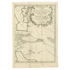
Ancient Crossroads: Albania to Assyria in Antiquity, Published in 1880
About the Item
The map titled "ALBANIA, IBERIA, COLCHIS, ARMENIA, MESOPOTAMIA, BABYLONIA, ASSYRIA" portrays the ancient regions that would encompass parts of modern-day Eastern Turkey, Armenia, Azerbaijan, Georgia, Iran, Iraq, and Syria.
Some interesting facts of this original antique map:
1. **Ancient Civilizations**: It covers the heartland of some of the oldest civilizations in the world, including Assyria, Babylonia, and Armenia, with a history that stretches back thousands of years.
2. **Geographical Features**: The map shows significant geographical features such as the Tigris and Euphrates rivers, the Caucasus mountain range, and the Black Sea (Pontus Euxinus), which were crucial to the development and sustenance of these civilizations.
3. **Historical Routes**: It likely outlines ancient trade routes, such as the Silk Road and other lesser-known paths that facilitated the movement of goods, armies, and ideas.
4. **Political Boundaries**: The boundaries indicated may reflect the political situation during various periods, such as the Assyrian Empire, the Kingdom of Armenia, or the Hellenistic states following Alexander the Great's conquests.
5. **Inset Maps**: If any, would provide a closer look at specific regions, illustrating the detailed knowledge of the area's geography during the time of the map's creation.
6. **Latin Labels**: The use of Latin in labeling and descriptions is characteristic of scholarly works of the 19th century, emphasizing the map's academic and educational purpose.
The period the map likely represents is the classical antiquity, particularly the era of Roman geopolitical interest in these regions, which might range from the 1st millennium BC to the first few centuries AD. This map would be of particular interest to those studying the ancient Near East and the complex interplay of cultures, empires, and trade that characterized the region.
The map is from the "Spruner-Menke Atlas Antiquus," which is a historical atlas created by Karl Spruner von Merz, and later edited by Theodorus Menke. The atlas is known for its detailed maps of historical geographic regions, rendered with great precision and accompanied by scholarly research. These maps were particularly designed for educational use, providing a visual aid for the study of historical and ancient geography. The "Spruner-Menke Atlas Antiquus" is considered a significant work in the field of historical cartography and was published in the late 19th century.
- Dimensions:Height: 18.51 in (47 cm)Width: 15.56 in (39.5 cm)Depth: 0 in (0.02 mm)
- Materials and Techniques:
- Period:
- Date of Manufacture:1880
- Condition:Good, given age. General age-related toning, especially around the edges. horizontal folding line as issued. Please study scan carefully.
- Seller Location:Langweer, NL
- Reference Number:
About the Seller
5.0
Platinum Seller
These expertly vetted sellers are 1stDibs' most experienced sellers and are rated highest by our customers.
Established in 2009
1stDibs seller since 2017
1,916 sales on 1stDibs
Typical response time: <1 hour
- ShippingRetrieving quote...Ships From: Langweer, Netherlands
- Return PolicyA return for this item may be initiated within 14 days of delivery.
More From This SellerView All
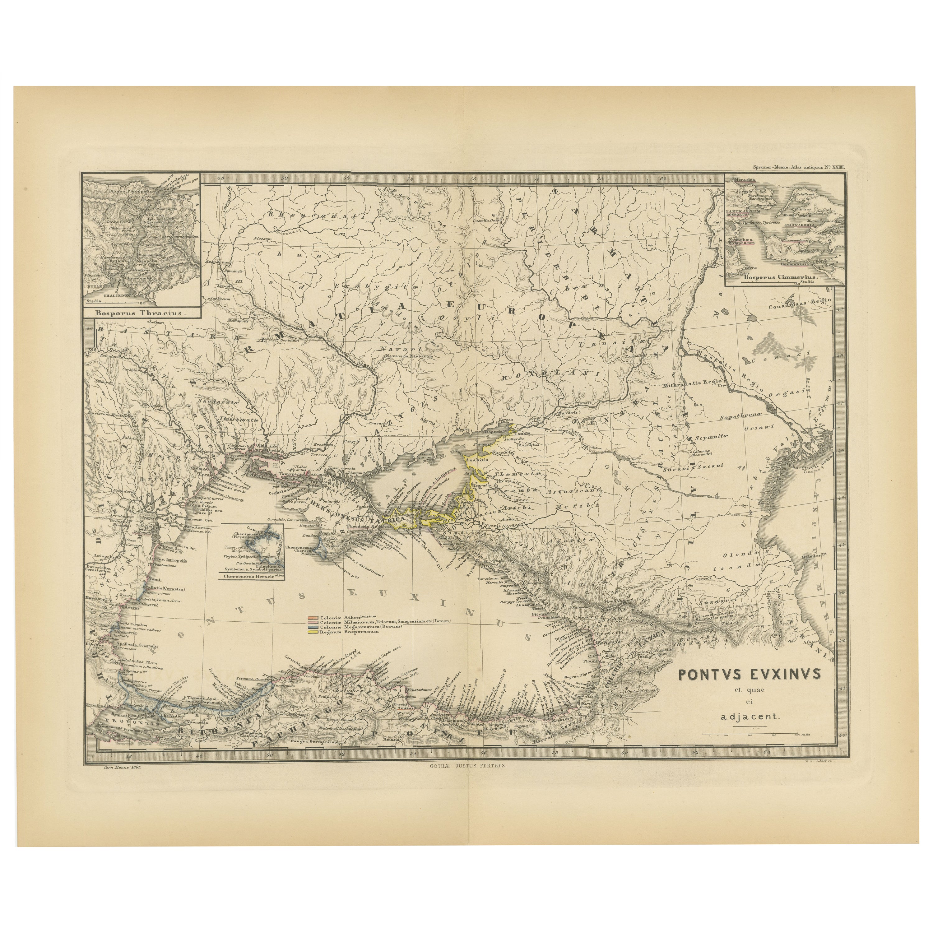
- Black Sea in Antiquity: Pontus Euxinus Map, Published in 1880Located in Langweer, NLThis map, titled "PONTUS EUXINUS," depicts the Black Sea region, historically known as the Pontus Euxinus. The Black Sea was central to ancient trade routes and cultural exchange, bo...Category
Antique 1880s Maps
MaterialsPaper
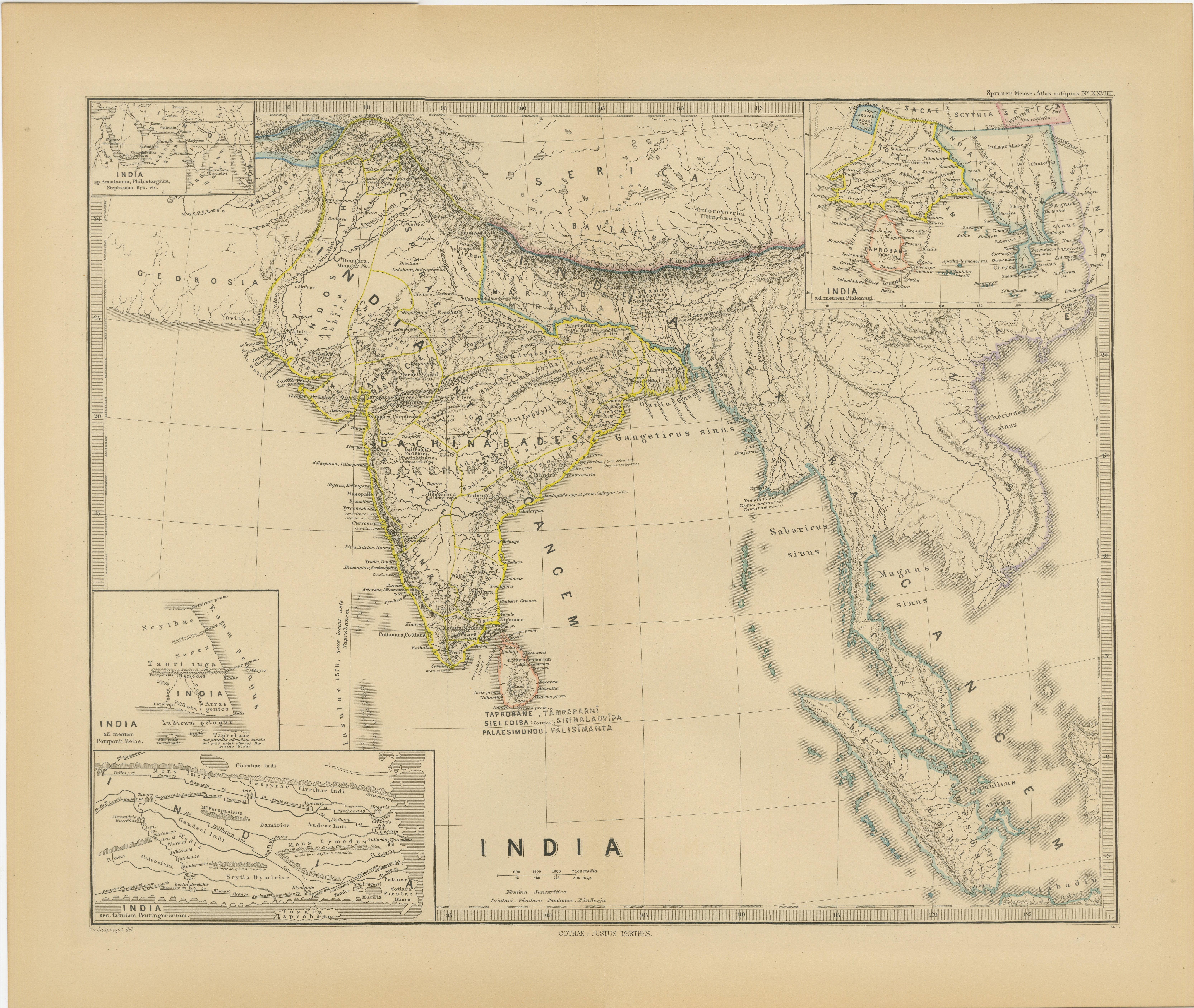
- Ancient Cartography of the Indian Subcontinent, Published in 1880Located in Langweer, NLThis map is titled "INDIA," and it provides a detailed view of the Indian subcontinent with various inset maps that offer additional historical and geographical context. The main ma...Category
Antique 1880s Maps
MaterialsPaper
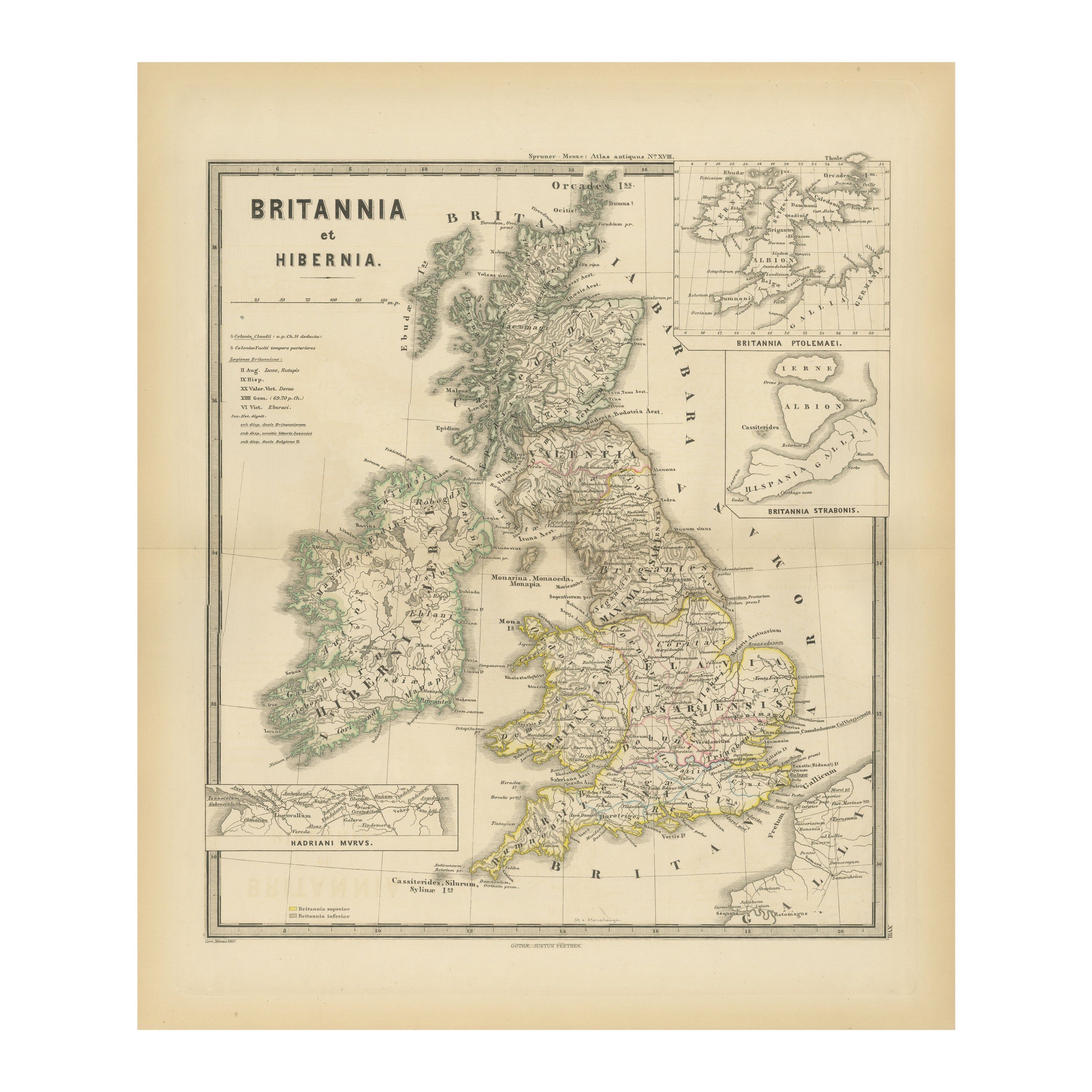
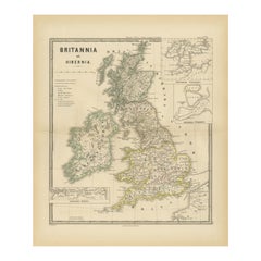
- Ancient Cartography of Britannia and Hibernia, Published in 1880Located in Langweer, NLThis map depicts the geographical area of Great Britain and Ireland, labeled "BRITANNIA et HIBERNIA." It is a historical map, as indicated by the Latin titles and the classical names of regions and tribes. In the main section of the map, Great Britain is depicted in fine detail, with topographical features such as mountains and rivers. The map is color-coded, to differentiate political or tribal boundaries. Various Roman place names are indicated, such as "Londinium" for London. To the left of Great Britain is Ireland, referred to as "Hibernia," similarly detailed with its own topographical features and ancient...Category
Antique 1880s Maps
MaterialsPaper
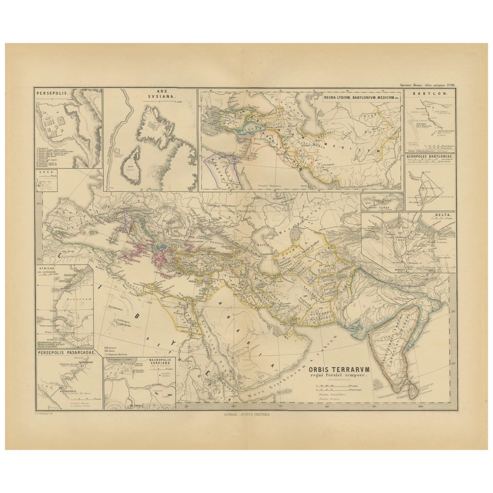
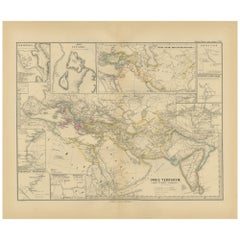
- Empires of Antiquity: The Persian Realm and Beyond Engraved, Published in 1880Located in Langweer, NLThe map is titled "ORBIS TERRARUM regni Persici tempore," which translates from Latin to "The World at the Time of the Persian Empire." This map is particularly interesting for sever...Category
Antique 1880s Maps
MaterialsPaper
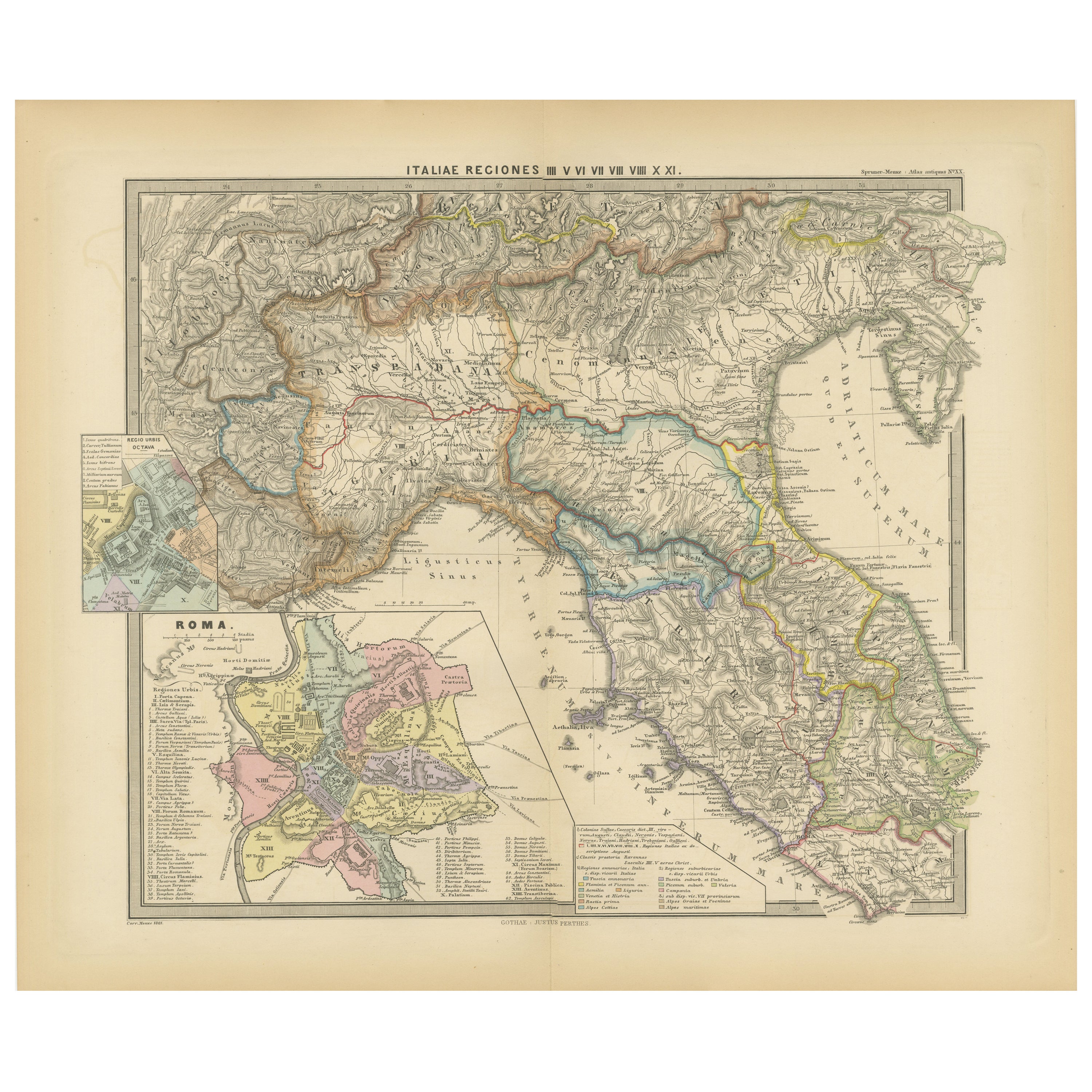
- Ancient Italy: Regions and Rome in the Roman Empire, Published in 1880Located in Langweer, NLThis print is an original detailed map titled "ITALIAE REGIONES I VII VIII IX XI," representing the regions of ancient Italy. Key Features of the Print: 1. **Regional Demarcations...Category
Antique 1880s Maps
MaterialsPaper
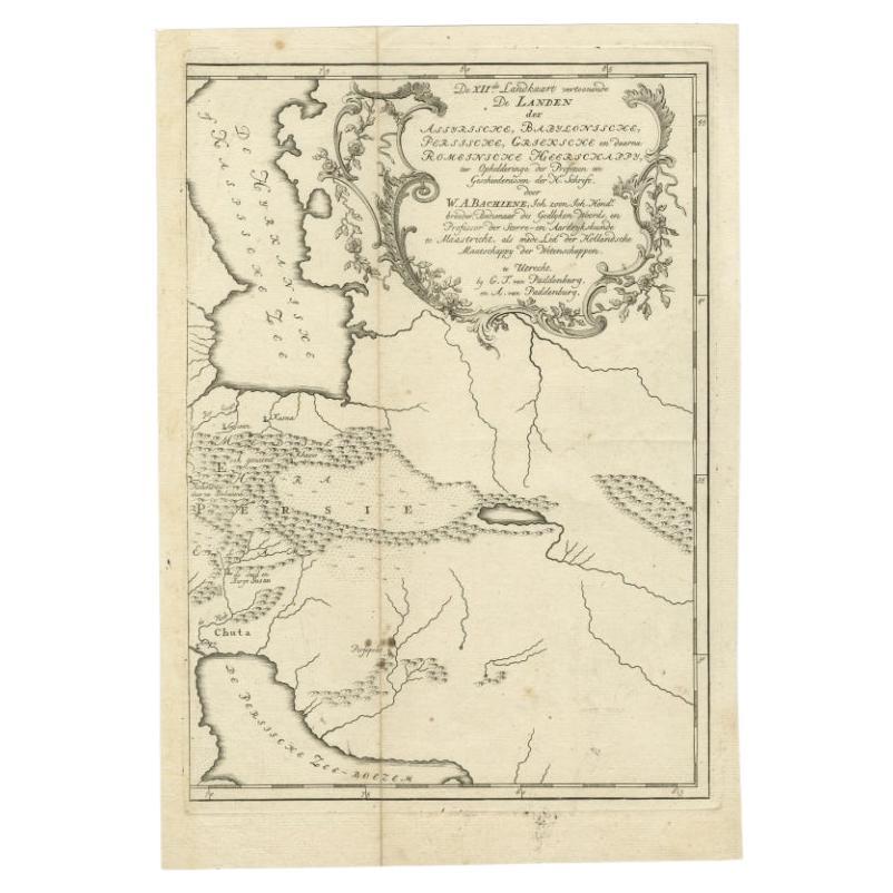
- Antique Map of Ancient Persia, Assyria and surroundings, c.1760Located in Langweer, NLAntique map titled 'De XII de Landkaart vertoonende de Landen der Assyrische, Babylonische, Persische, Grieksche en daarna Romeinsche Heerschappy.' Map of ancient Persia...Category
Antique 18th Century Maps
MaterialsPaper


You May Also Like
- Sotheby's: The Breitbart Collection of Antiquities & Ancient Glass, 6/1990Located in valatie, NYSotheby's: The Breitbart Collection of Antiquities & Ancient Glass, 6/1990. 145 lots, Ancient Glass; Egyptian, Western Asiatic, and classical antiquities...Category
1990s American Books
MaterialsPaper
- Sotheby's Antiquities Catalog Benzina Collection of Ancient Glass July 1994Located in Stamford, CTSotheby's auction catalog of the exceptional Benzian Collection of Ancient and Islamic Glass. An invaluable reference for the collector, scholar or anyone interested in the most delicate and beautiful of antiquities, ancient glass...Category
20th Century English Classical Roman Books
MaterialsPaper
- Jean-Michel Basquiat CrossroadsBy Rizzoli International PublicationsLocated in New York, NYAuthor Lee Jaffe, Foreword by Franklin Sirmans, Contributions by J. Faith Almiron A rare and poignant compilation of photography and written anecdotes by American photographer and...Category
21st Century and Contemporary Books
MaterialsPaper
- Dick Morrill: A Part to Play in the Process, Published by Katharine T. CarterLocated in valatie, NYDick Morrill: A Part to Play in the Process, Published by Katharine T. Carter. 1st Ed softcover. Outstanding and vibrant photographs of this artist's work. "Dick Morrill makes narrat...Category
21st Century and Contemporary Books
MaterialsPaper
- Letters of the Earl of Chesterfield to His Son in 4 Volumes Published 1787Located in San Francisco, CAEarl of Chesterfield's letters to his son and luminaries of the day in 4 volumes in their original full leather bindings, published London J. Dodsley 1787. The spines have raised ban...Category
Antique Late 18th Century English George III Books
MaterialsPaper, Leather
- Antique Paterson's Guide to Britain, English, Maps, Georgian, Published 1811Located in Hele, Devon, GBThis is an antique copy of Paterson's New and Accurate guide to Direct & Principal Crossroads. An English, bound book of maps and descriptive tables, published in English by Longman,...Category
Antique Early 19th Century British Georgian Books
MaterialsPaper