Items Similar to Antique Chart of the Straits of Makassar, Indonesia with Borneo and Celebes-1820

Want more images or videos?
Request additional images or videos from the seller
1 of 5
Antique Chart of the Straits of Makassar, Indonesia with Borneo and Celebes-1820
About the Item
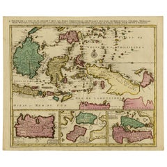
Description: Antique map titled 'A New Chart of the Straits of Macassar with various additions & improvements by J.W. Norie'.
Rare and beautifully engraved chart of the Straits of Makassar showing Eastern Borneo and Celebes coast lines. With various smaller inset maps including a plan of the shoals off ragged and shoal points in Borneo, the Bay of Bonthain and the Straits of Salayr.
Artists and Engravers: John William Norie (1772-1843), acquired the chart publishing business of William Heather after he died in 1812. He went into partnership with George Wilson (1753-1831). Norie became a prolific hydrographer, chart publisher and author of navigation textbooks and pilots (sailing directions). The first catalogue of "J.W. Norie & Co. (Successors to the late William Heather) Chartsellers to the Admiralty, and the Honourable East India Company" lists 143 charts, of which 27 cover Eastern Navigation. Cape of Good Hope, Isle of France, Indian Ocean, Bay of Bengal, East Indies, China, New Holland &c." These include (as no. 132) The Straits of Malacca and Sincapore (sic) with separate Plans of Cornwallis Roads at Prince of Wales's Island, Bass Harbour, and the Straits of Sincapore, priced at 7s 6d.
Condition:
Good, general age-related toning and some foxing. Minor wear and small defects. Blank verso, please study image carefully.
- Dimensions:Height: 37.8 in (96 cm)Width: 25.99 in (66 cm)Depth: 0 in (0.02 mm)
- Materials and Techniques:
- Period:
- Date of Manufacture:1820
- Condition:Wear consistent with age and use.
- Seller Location:Langweer, NL
- Reference Number:
About the Seller
5.0
Platinum Seller
These expertly vetted sellers are 1stDibs' most experienced sellers and are rated highest by our customers.
Established in 2009
1stDibs seller since 2017
1,933 sales on 1stDibs
Typical response time: <1 hour
- ShippingRetrieving quote...Ships From: Langweer, Netherlands
- Return PolicyA return for this item may be initiated within 14 days of delivery.
More From This SellerView All
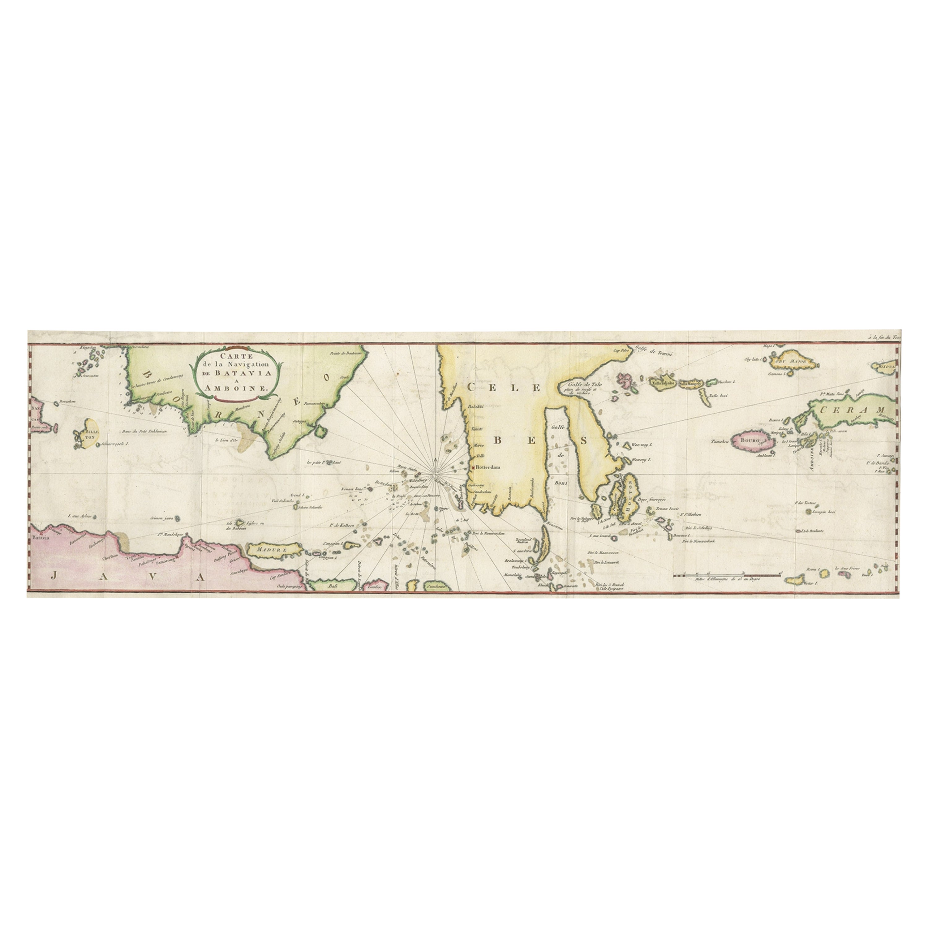
- Rare Chart of Indonesia Including Borneo, Java, Celebes, Ceram and More, 1779Located in Langweer, NLAntique map titled 'Carte de la Navigation de Batavia a Amboina'. Rare chart of Indonesia including Borneo, Java, Celebes, Ceram and more. This map originates from 'Voyage par le Cap...Category
Antique 1770s Maps
MaterialsPaper
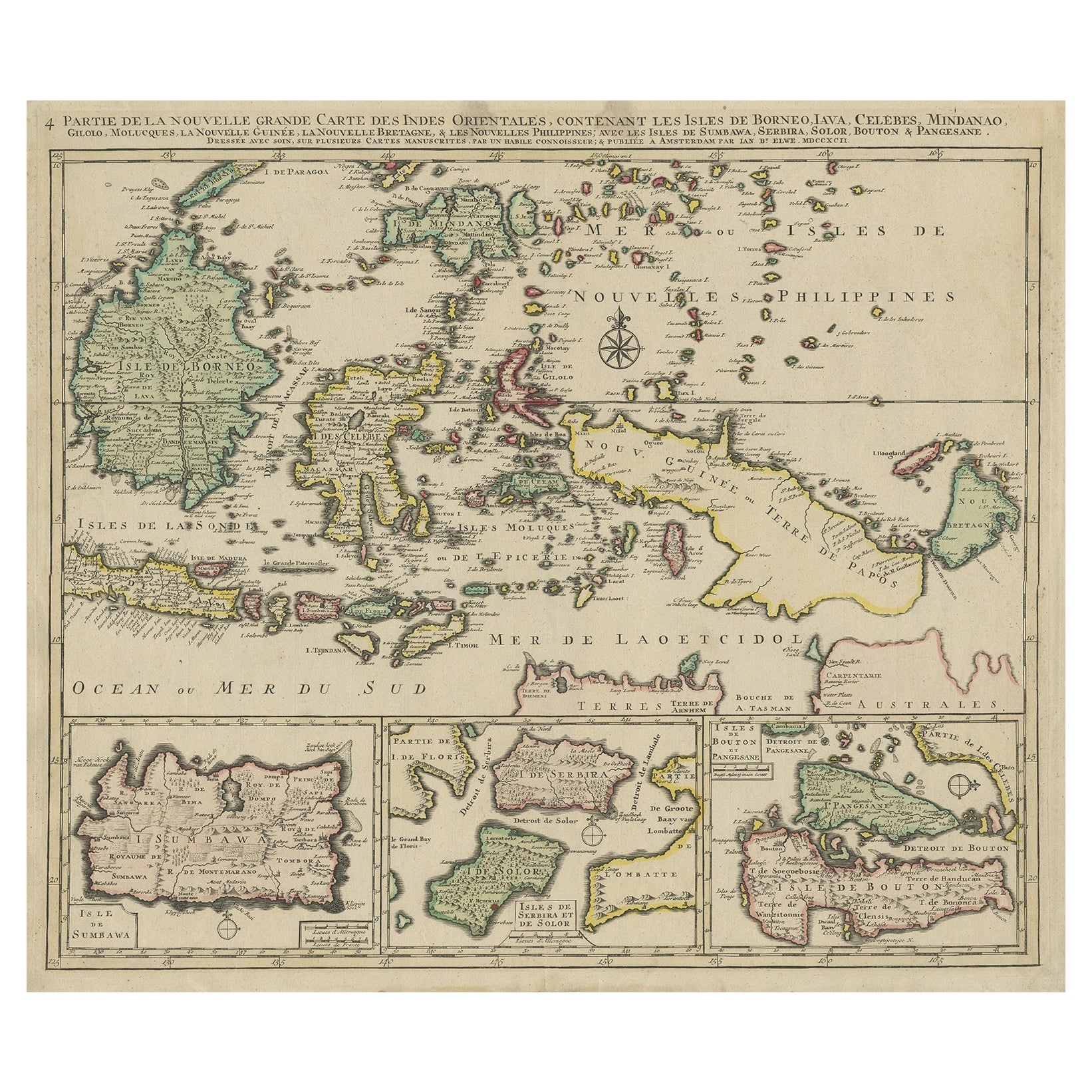
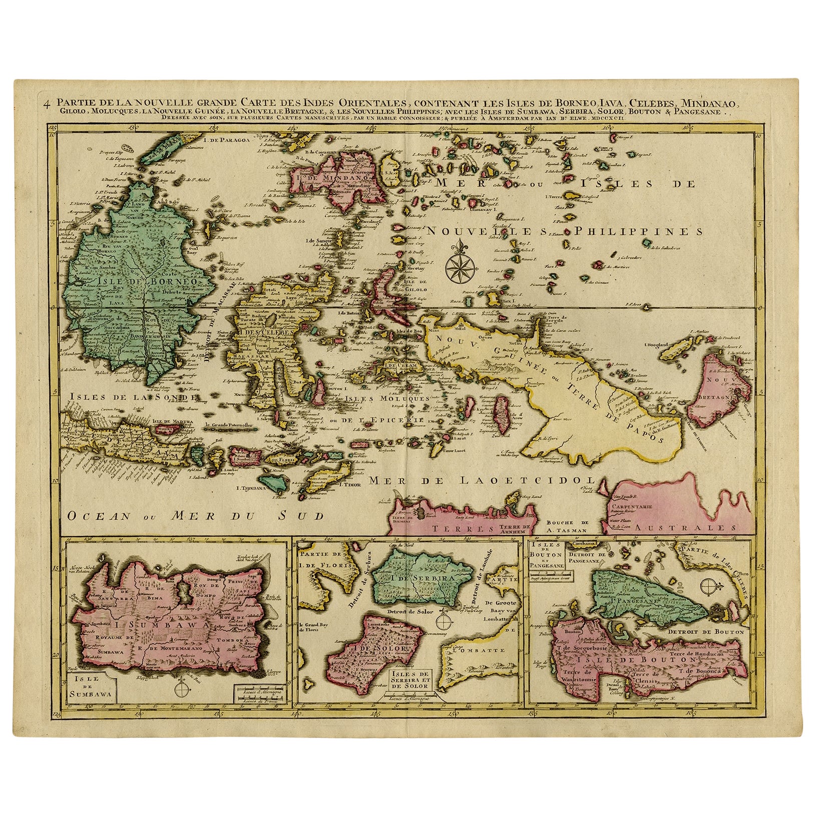
- Old Map of the East Indonesian Islands Borneo, Celebes, New Guinea, Bali, 1792Located in Langweer, NLAntique map titled 'Partie de la Nouvelle Grande Carte des Indes Orientales, contenant les Isles de Borneo, Iava, Celebes, Mindanao (..)'. Detailed map of the Indonesian islands ...Category
Antique 1790s Maps
MaterialsPaper
- Old Map of Indonesian Islands Borneo, Celebes, New Guinea & New Britain, 1792Located in Langweer, NLAntique map titled 'Partie de la Nouvelle Grande Carte des Indes Orientales, contenant les Isles de Borneo, Iava, Celebes, Mindanao (..)'. Detailed map of the Indonesian islands Bo...Category
Antique 1790s Maps
MaterialsPaper
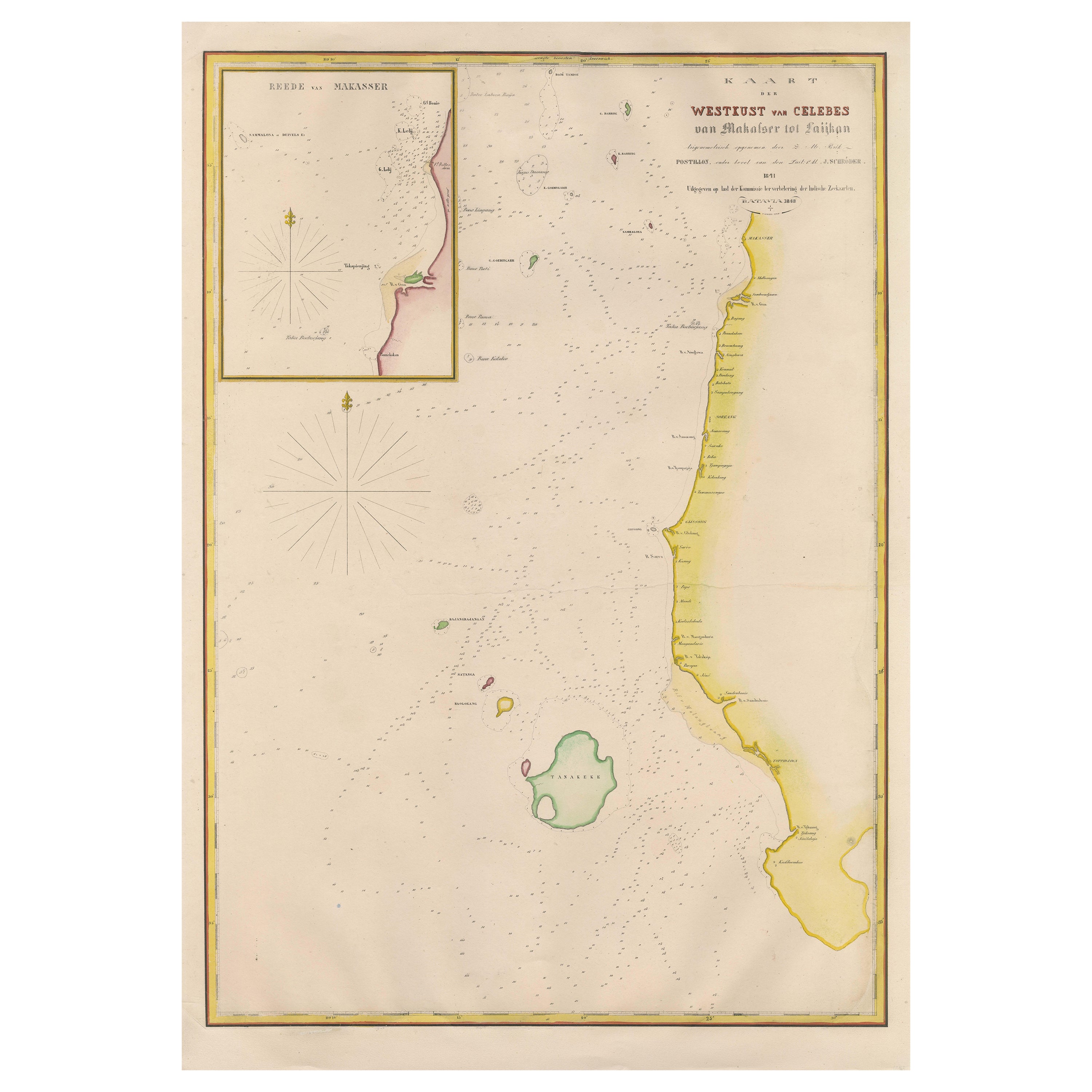
- Large Antique Map of the west coast of Celebes, Sulawesi, IndonesiaLocated in Langweer, NLOriginal antique map titled 'Kaart der Westkust van Celebes van Makasser tot Laijkan'. This large map shows the west coast of Celebes, Sulawesi, Indonesia. It covers the region of Makassar to Cikoang. Inset map of the coast of Selat (Strait) Makassar, also showing the Dutch Fort Rotterdam, to day Fort Ujung Pandang. With historical traces dating back to the Kingdom of Gowa from the 16th century to colonization by the Dutch, this Fort has silently witnessed many episodes in Makassar’s history, playing a most essential role in its development. Originally called Benteng or Fort Jumpandang or Ujung Pandang, the huge complex was first built in 1545 in the era of Imanrigau Daeng Bonto Karaeng Lakiung or Karaeng Tunipalangga Ulaweng, the tenth King of Gowa. Initially, the fort was made from a mixture of Stone and burnt clay, and took the shape of a typical square Portuguese architectural...Category
Antique Mid-19th Century Maps
MaterialsPaper
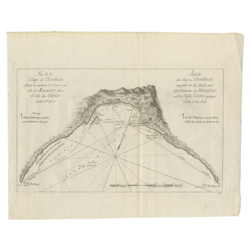
- Antique Map of a Bay Nearby Makassar, Celebes 'Sulawesi)' by Hawkesworth, 1774Located in Langweer, NLAntique map titled 'Vue de la Baye de Bonthain (..)'. Map of the island Sulawesi (Celebes), Indonesia that Philip Carteret rested his crew and made repairs to his ship the Swallow fo...Category
Antique 18th Century Maps
MaterialsPaper
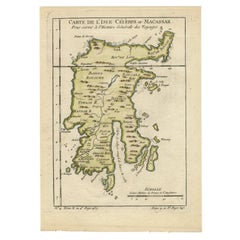
- Antique Map of Celebes 'Sulawesi', Island in Indonesia, 1754By Jacques-Nicolas BellinLocated in Langweer, NLAntique map titled 'Carte De L'Isle Celebes ou Macassar'. Detailed copper engraved map of Celebes (Sulawesi, Indonesia), showing Makassar, which was the most important trading city o...Category
Antique 18th Century Maps
MaterialsPaper
You May Also Like
- Chart of the Harbour of LiverpoolLocated in Cheshire, GBPL Burdett A Chart of the Harbour of Liverpool hand coloured. Encased in an ebonised frame. Dimensions Height 23.5 Inches Width 28 Inches Depth 1 InchesCategory
Early 20th Century British Maps
MaterialsPaper
- Large Original Antique Map of Java and Borneo, Fullarton, C.1870Located in St Annes, LancashireGreat map of Java and Borneo Wonderful figurative borders From the celebrated Royal Illustrated Atlas Lithograph. Original color. Published by Fullarton, Edinburgh. C.1870 Unfr...Category
Antique 1870s Scottish Maps
MaterialsPaper
- 1865 Chart of the Islands of MadeiraLocated in Norwell, MARare James Imray chart from 1865 titled "Chart of the Islands of Madeira, Porto Santo and Dezerea" drawn from the survey made by Captain Ate Vidal Royal Navy, London. Published by Ja...Category
Antique 1860s European Maps
MaterialsPaper
- The Indonesian TableLocated in New York City, NY‘It is truly remarkable for a talented chef to also be a sensational storyteller … Petty takes you on a journey across the archipelago, through her food and her life.’ – Julien Royer...Category
21st Century and Contemporary Chinese Books
MaterialsPaper
- Antique Anatomical Wall Chart Depicting the Human SkeletonLocated in Berghuelen, DEA rare 19th century anatomical wall chart depicting the human skeleton. On the sides On the sides are detailed description in German language. The wall...Category
Early 20th Century German Victorian Prints
MaterialsPaper
- Original Antique Map of Indonesia, 1861Located in St Annes, LancashireGreat map of Indonesia Drawn and engraved by Edward Weller Original color Published in The Weekly Dispatch Atlas, 1861 Repairs to minor e...Category
Antique 1860s English Victorian Maps
MaterialsPaper