Items Similar to Antique Map of the Artois Region of France by Ortelius, 'circa 1590'


Want more images or videos?
Request additional images or videos from the seller
1 of 5
Antique Map of the Artois Region of France by Ortelius, 'circa 1590'
About the Item
Antique map titled 'Artesia'. Original antique map of the Artois region, France. Published by A. Ortelius, circa 1590.
- Dimensions:Height: 17.13 in (43.5 cm)Width: 21.66 in (55 cm)Depth: 0.02 in (0.5 mm)
- Materials and Techniques:
- Period:
- Date of Manufacture:circa 1590
- Condition:Repaired: Repair on folding line and a few small tears in the margins. Original/contemporary hand coloring. Latin text on verso. Small split on folding line. Few small repairs. General age-related toning, please study images carefully.
- Seller Location:Langweer, NL
- Reference Number:
About the Seller
5.0
Platinum Seller
These expertly vetted sellers are 1stDibs' most experienced sellers and are rated highest by our customers.
Established in 2009
1stDibs seller since 2017
1,929 sales on 1stDibs
Typical response time: <1 hour
- ShippingRetrieving quote...Ships From: Langweer, Netherlands
- Return PolicyA return for this item may be initiated within 14 days of delivery.
More From This SellerView All
- Antique Map of the Picardy Region of France by Ortelius, 'circa 1590'Located in Langweer, NLAntique map titled 'Picardiae Belgicae regionis descriptio'. Original antique map of the Picardy region, France. Published by A. Ortelius, circa 1590.Category
Antique 16th Century Maps
MaterialsPaper
- Antique Map of the Artois Region 'France' by F. de Wit, circa 1680Located in Langweer, NLAntique map titled 'Tabula Comitatus Artesiae emendata'. Large map of the Artois region, France. Published by F. de Wit, circa 1680.Category
Antique Late 17th Century Maps
MaterialsPaper
- Antique Map of the Region of Poitou by Ortelius, circa 1600Located in Langweer, NLAntique map titled 'Poictou'. Original antique map of the region of Poitou, a former province of west-central France whose capital city was Poitiers. Published by A. Ortelius, circa ...Category
Antique Early 17th Century Maps
MaterialsPaper
- Antique Map of the Region of Salzburg by Ortelius 'circa 1606'Located in Langweer, NLAntique map titled 'Salisburgensis Iurisdictionis'. Original antique map of the region of Salzburg, Austria. Published by A. Ortelius, circa 1606.Category
Antique Early 17th Century Maps
MaterialsPaper
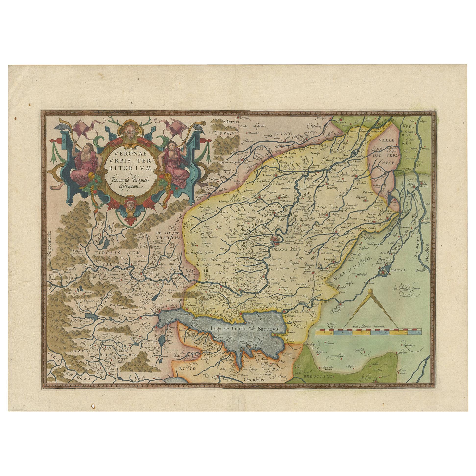
- Antique Map of the Region of Verona 'Italy' by Ortelius, circa 1584Located in Langweer, NLAntique map titled 'Veronae Urbis Terratorium'. Original antique map of the Verona region, Italy. Centered on Verona, and including Mantua, and Lago de Garda. Published by A. Orteliu...Category
Antique Late 19th Century Maps
MaterialsPaper
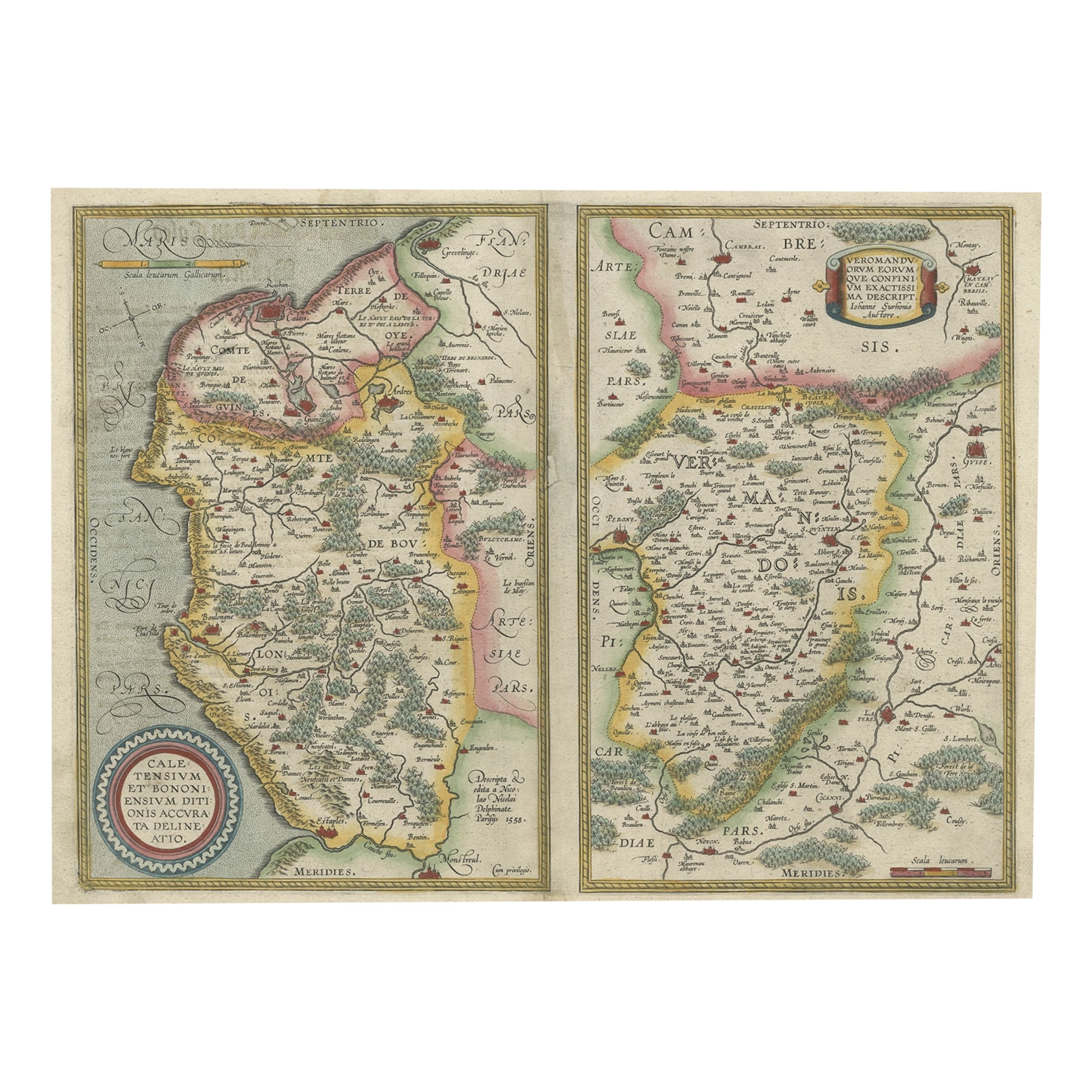
- Antique Map of the Region of Boulogne and Peronne, France 'C.1590'Located in Langweer, NLAntique map titled 'Caletensium et Bononiensium (..)'. Two detailed regional maps on one sheet. The first map shows Belgian and French Coastal region, from Estaples to Gruerlinge...Category
Antique 16th Century Maps
MaterialsPaper


You May Also Like
- The Normandy Region of France: A 17th C. Hand-colored Map by Sanson and JaillotBy Nicolas SansonLocated in Alamo, CAThis large hand-colored map entitled "Le Duché et Gouvernement de Normandie divisée en Haute et Basse Normandie en divers Pays; et par evêchez, avec le Gouvernement General du Havre ...Category
Antique 1690s French Maps
MaterialsPaper
- 17th Century Hand Colored Map of the Liege Region in Belgium by VisscherBy Nicolaes Visscher IILocated in Alamo, CAAn original 17th century map entitled "Leodiensis Episcopatus in omnes Subjacentes Provincias distincté divisusVisscher, Leodiensis Episcopatus" by Nicolaes Visscher II, published in Amsterdam in 1688. The map is centered on Liege, Belgium, includes the area between Antwerp, Turnhout, Roermond, Cologne, Trier and Dinant. This attractive map is presented in a cream-colored mat measuring 30" wide x 27.5" high. There is a central fold, as issued. There is minimal spotting in the upper margin and a tiny spot in the right lower margin, which are under the mat. The map is otherwise in excellent condition. The Visscher family were one of the great cartographic families of the 17th century. Begun by Claes Jansz Visscher...Category
Antique Late 17th Century Dutch Maps
MaterialsPaper
- Original Antique Map of Belgium by Tallis, Circa 1850Located in St Annes, LancashireGreat map of Belgium Steel engraving Many lovely vignettes Published by London Printing & Publishing Co. ( Formerly Tallis ), C.1850 Origin...Category
Antique 1850s English Maps
MaterialsPaper
- Original Antique Map of The World by Thomas Clerk, 1817Located in St Annes, LancashireGreat map of The Eastern and Western Hemispheres On 2 sheets Copper-plate engraving Drawn and engraved by Thomas Clerk, Edinburgh. Published by Mackenzie And Dent, 1817 ...Category
Antique 1810s English Maps
MaterialsPaper
- Original Antique Map of France, Arrowsmith, 1820Located in St Annes, LancashireGreat map of France Drawn under the direction of Arrowsmith. Copper-plate engraving. Published by Longman, Hurst, Rees, Orme and Brown, 1820 Unframed.Category
Antique 1820s English Maps
MaterialsPaper
- 17th Century Topographical Map, French Champagne Region, Epernay, Iohan PeetersLocated in New York, NYFine topographical 17th century map by Iohan Peeters of the towns of Epernay and Lametz in the Champagne Region of North Eastern France. Fabulous period engraving for a Wine Cellar,...Category
Antique 17th Century Dutch Maps
MaterialsPaper


