Items Similar to Antique Map of Borneo and Malaysia by P.M.G. Vandermaelen, 1827

Want more images or videos?
Request additional images or videos from the seller
1 of 5
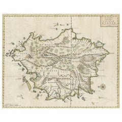
Antique Map of Borneo and Malaysia by P.M.G. Vandermaelen, 1827
About the Item
A chart of the north western part of Borneo and Malaysia (Sarawak). Published by P.M.G. Vandermaelen, 1827.
- Dimensions:Height: 20.87 in (53 cm)Width: 28.67 in (72.8 cm)Depth: 0.02 in (0.5 mm)
- Materials and Techniques:
- Period:
- Date of Manufacture:1827
- Condition:Please study image carefully.
- Seller Location:Langweer, NL
- Reference Number:
About the Seller
5.0
Platinum Seller
These expertly vetted sellers are 1stDibs' most experienced sellers and are rated highest by our customers.
Established in 2009
1stDibs seller since 2017
1,933 sales on 1stDibs
Typical response time: <1 hour
- ShippingRetrieving quote...Ships From: Langweer, Netherlands
- Return PolicyA return for this item may be initiated within 14 days of delivery.
More From This SellerView All
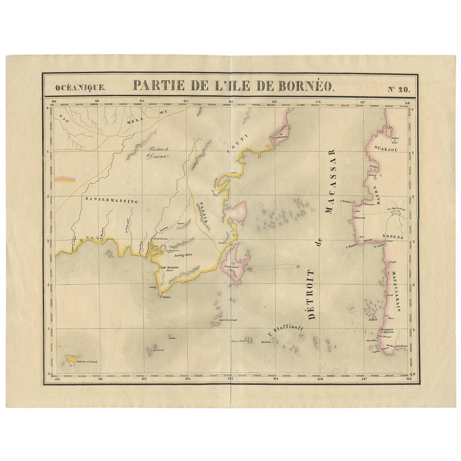
- Antique Map of Southeast Borneo by P.M.G. Vandermaelen, 1827Located in Langweer, NLStriking and highly detailed unusual large-format fine example of Vandermaelen's map covering part of the south-eastern part of Borneo and western tip of Sulawesi. The map provides g...Category
Antique Early 19th Century Maps
MaterialsPaper
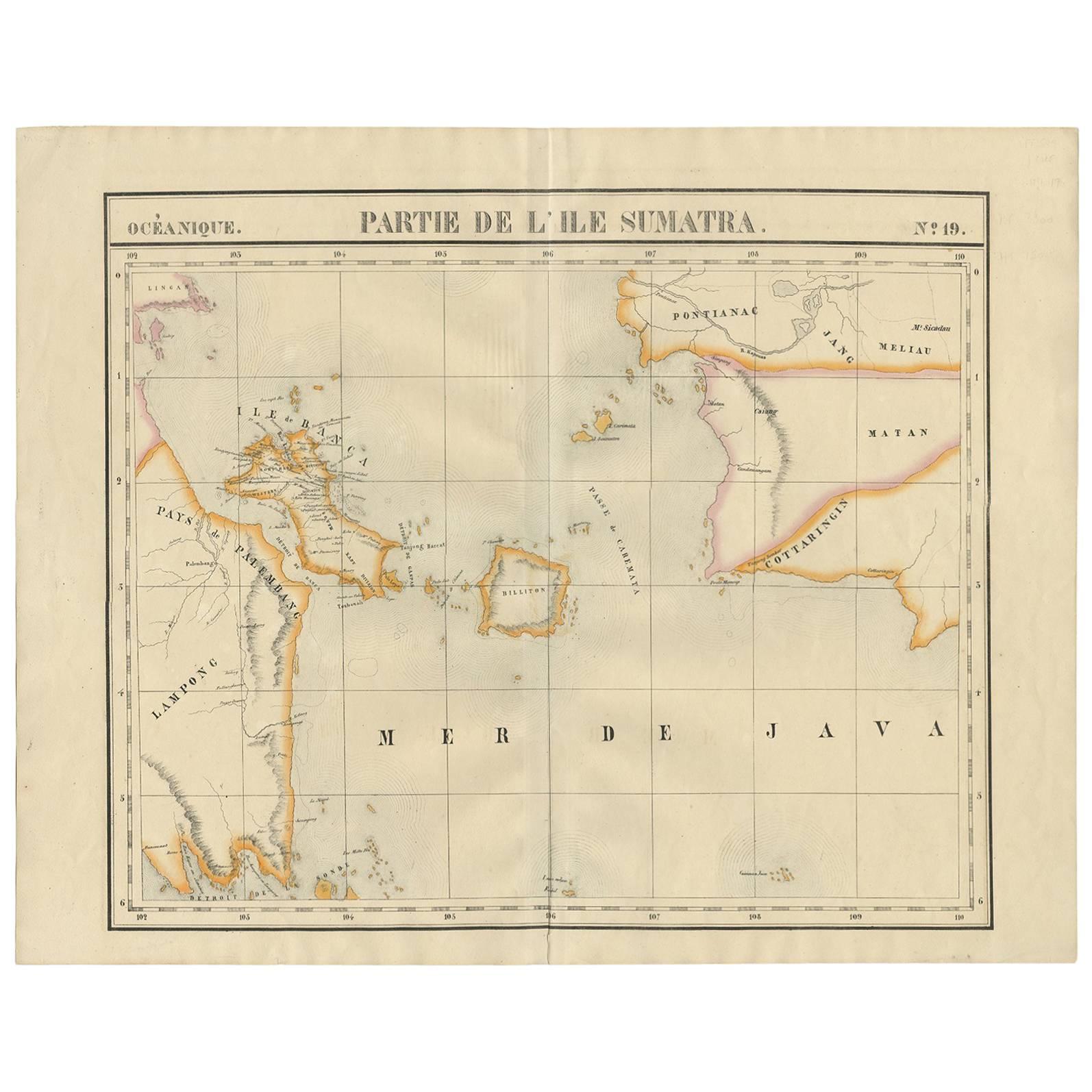
- Antique Map of South Sumatra by P.M.G. Vandermaelen, 1827Located in Langweer, NLA chart showing the southern part of Sumatra, the island of Belitung and southern Borneo, published in the "Atlas Universel de Géographie".Category
Antique Early 19th Century Maps
MaterialsPaper
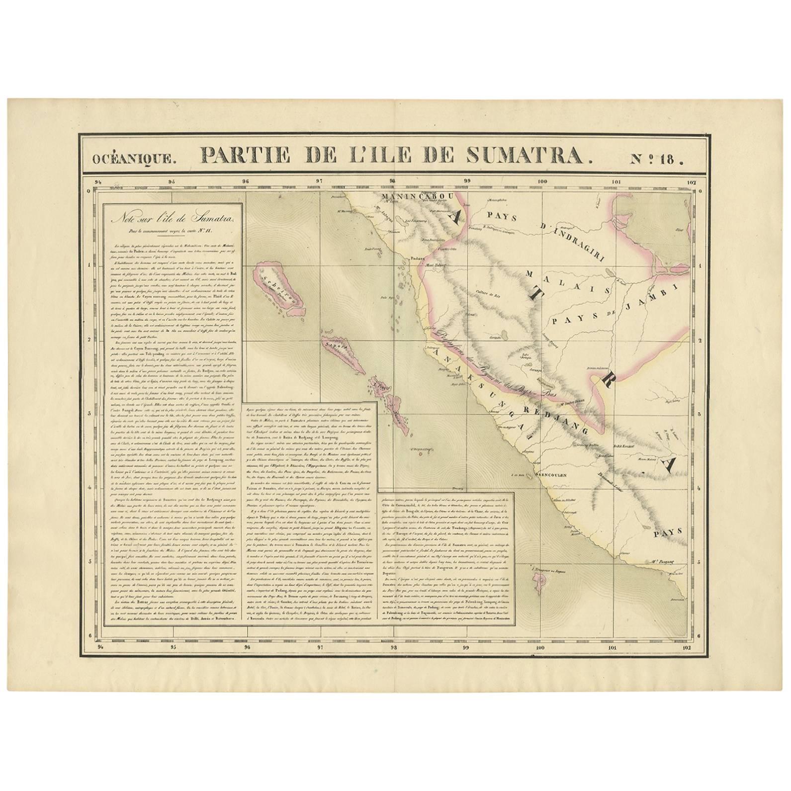
- Antique Map of West Sumatra by P.M.G. Vandermaelen, 1827Located in Langweer, NLA chart showing the western part of Sumatra, published in the "Atlas Universel de Géographie".Category
Antique Early 19th Century Maps
MaterialsPaper
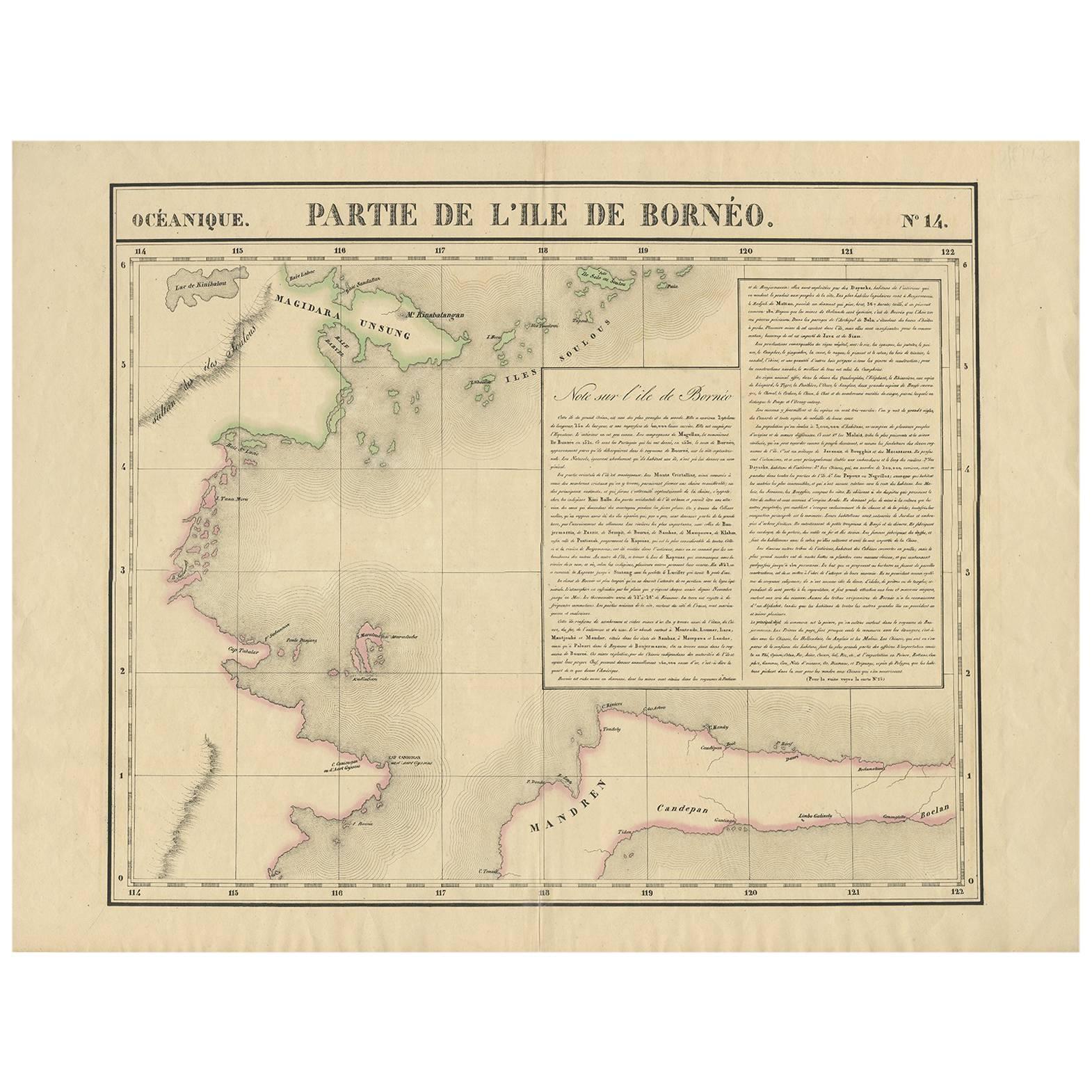
- Antique Map of North East Borneo and North Sulawesi by P.M.G. VandermaelenLocated in Langweer, NLContemporary colored lithographed map. Relief shown pictorially and by hachures. Covers North Eastern Borneo and part of Northern Sulawesi.Category
Antique Early 19th Century Maps
MaterialsPaper
- Antique Map of Singapore, Malaysia, Borneo, Sumatra and Java (Indonesia), 1739Located in Langweer, NL"Antique map titled 'Nieuwe kaart van de Sundasche Eilanden als Borneo, Sumatra en Groot Iava & c'. Detailed map of Southeast Asia, extending from the tip of Cambodia to Java. This m...Category
Antique 18th Century Maps
MaterialsPaper
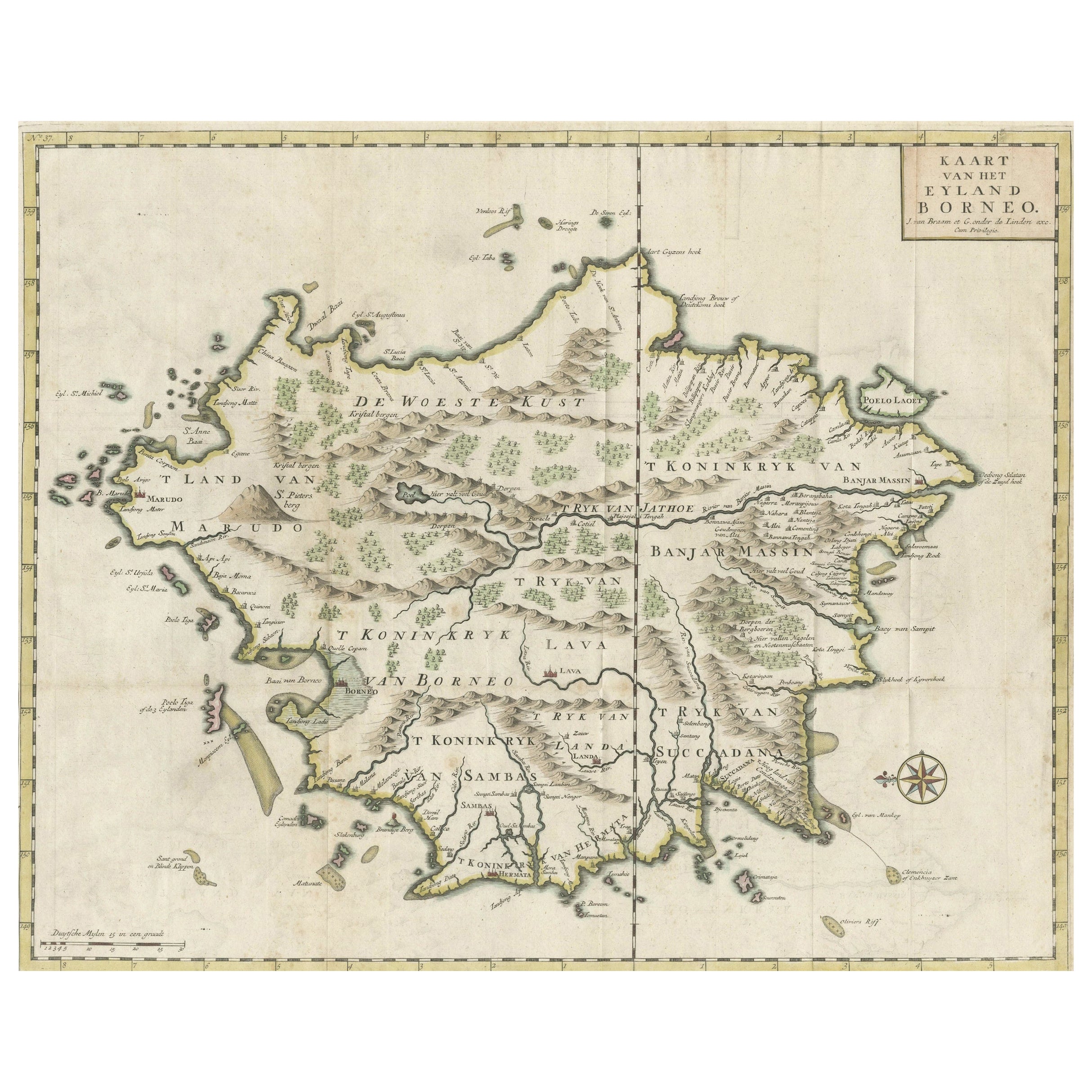
- Old Antique Map of Borneo 'Kalimantan Indonesia, Sabah Malaysia & Brunei'Located in Langweer, NLAntique map titled 'Kaart van het Eyland Borneo'. Original antique map of the island of Borneo. Published 1724-1726 by Joannes van Braam and Gerard Onder de ...Category
Antique Early 18th Century Maps
MaterialsPaper


You May Also Like
- Antique Map of Italy by Andriveau-Goujon, 1843By Andriveau-GoujonLocated in New York, NYAntique Map of Italy by Andriveau-Goujon, 1843. Map of Italy in two parts by Andriveau-Goujon for the Library of Prince Carini at Palazzo Carini i...Category
Antique 1840s French Maps
MaterialsLinen, Paper
- Antique Map of Principality of MonacoBy Antonio Vallardi EditoreLocated in Alessandria, PiemonteST/619 - "Old Geographical Atlas of Italy - Topographic map of ex-Principality of Monaco" - ediz Vallardi - Milano - A somewhat special edition ---Category
Antique Late 19th Century Italian Other Prints
MaterialsPaper
- Original Antique Map of Spain and Portugal, Engraved By Barlow, 1806Located in St Annes, LancashireGreat map of Spain And Portugal Copper-plate engraving by Barlow Published by Brightly & Kinnersly, Bungay, Suffolk. 1806 Unframed.Category
Antique Early 1800s English Maps
MaterialsPaper
- Original Antique Map of Russia By Arrowsmith. 1820Located in St Annes, LancashireGreat map of Russia Drawn under the direction of Arrowsmith Copper-plate engraving Published by Longman, Hurst, Rees, Orme and Brown, 1820 Unframed.Category
Antique 1820s English Maps
MaterialsPaper
- Original Antique Map of Ireland- Tipperary and Waterford. C.1840Located in St Annes, LancashireGreat map of Tipperary and Waterford Steel engraving Drawn under the direction of A.Adlard Published by How and Parsons, C.1840 Unframed.Category
Antique 1840s English Maps
MaterialsPaper
- Original Antique Map of Spain and Portugal, circa 1790Located in St Annes, LancashireSuper map of Spain and Portugal Copper plate engraving by A. Bell Published, circa 1790. Unframed.Category
Antique 1790s English Other Maps
MaterialsPaper


