Items Similar to Antique Map centered on Nuremberg, Germany

Want more images or videos?
Request additional images or videos from the seller
1 of 6
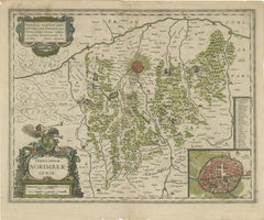
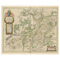
Antique Map centered on Nuremberg, Germany
$1,146.58
$1,433.2320% Off
£849.60
£1,06220% Off
€960
€1,20020% Off
CA$1,586.11
CA$1,982.6320% Off
A$1,748
A$2,18520% Off
CHF 915.14
CHF 1,143.9220% Off
MX$21,470.96
MX$26,838.7020% Off
NOK 11,498.88
NOK 14,373.6020% Off
SEK 10,762.04
SEK 13,452.5520% Off
DKK 7,311.11
DKK 9,138.8920% Off
About the Item
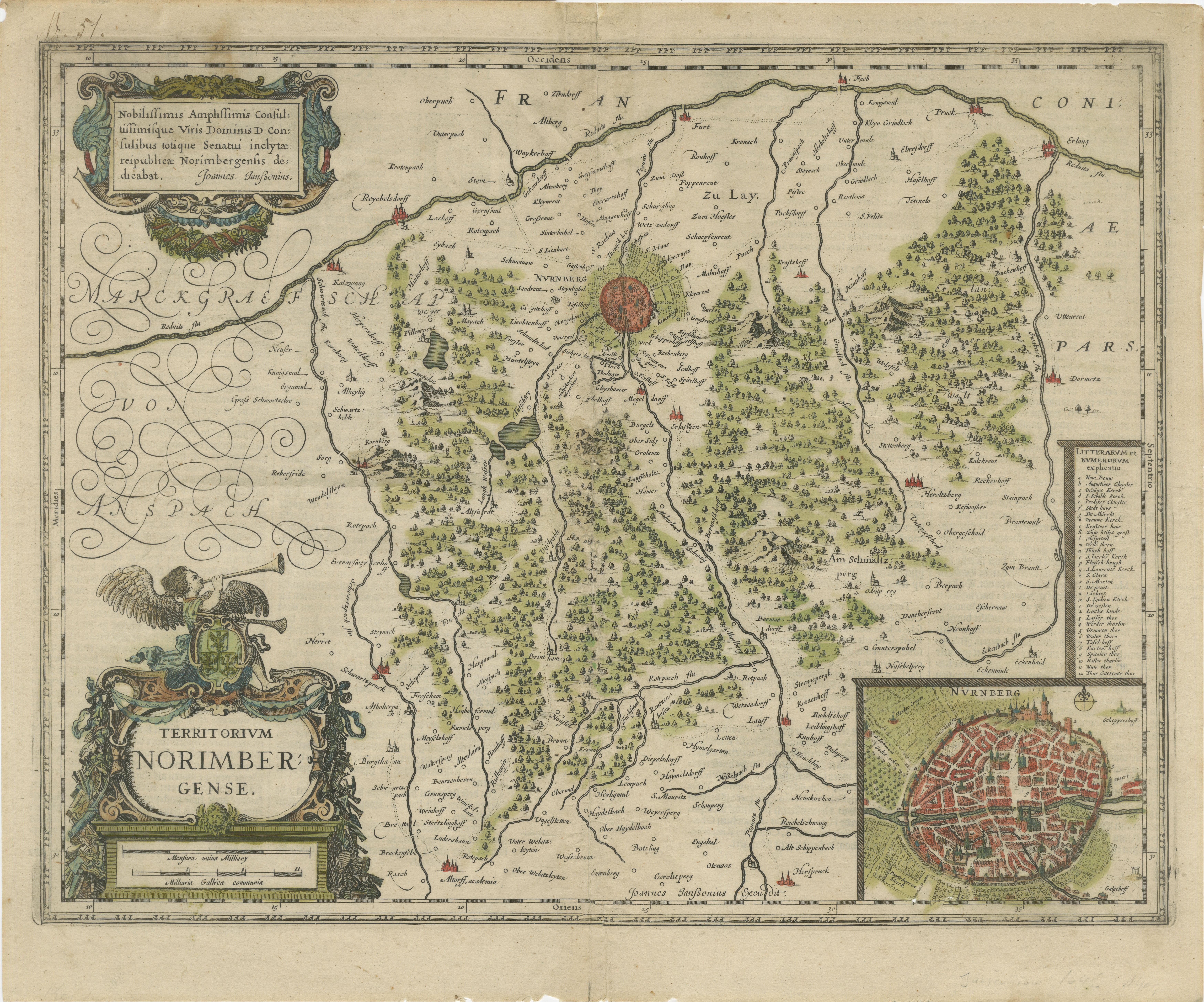
Antique map titled 'Territorium Norimbergense'. Beautiful map centered on Nuremberg, Germany. With decorative title cartouche and inset plan of the city. Published by W. Blaeu, circa 1635.
Willem Janszoon Blaeu (1571-1638) was a prominent Dutch geographer and publisher. Born the son of a herring merchant, Blaeu chose not fish but mathematics and astronomy for his focus. He studied with the famous Danish astronomer Tycho Brahe, with whom he honed his instrument and globe making skills. Blaeu set up shop in Amsterdam, where he sold instruments and globes, published maps, and edited the works of intellectuals like Descartes and Hugo Grotius. In 1635, he released his atlas, Theatrum Orbis Terrarum, sive, Atlas novus.
- Dimensions:Height: 16.42 in (41.7 cm)Width: 21.46 in (54.5 cm)Depth: 0.02 in (0.5 mm)
- Materials and Techniques:
- Period:Mid-17th Century
- Date of Manufacture:c.1635
- Condition:Repaired: Repair on folding line and a few closed tears. General age-related toning. Some wear and soiling. Blank verso. Please study image carefully.
- Seller Location:Langweer, NL
- Reference Number:Seller: BG-13441-31stDibs: LU3054335886462
About the Seller
5.0
Recognized Seller
These prestigious sellers are industry leaders and represent the highest echelon for item quality and design.
Platinum Seller
Premium sellers with a 4.7+ rating and 24-hour response times
Established in 2009
1stDibs seller since 2017
2,615 sales on 1stDibs
Typical response time: <1 hour
- ShippingRetrieving quote...Shipping from: Langweer, Netherlands
- Return Policy
Authenticity Guarantee
In the unlikely event there’s an issue with an item’s authenticity, contact us within 1 year for a full refund. DetailsMoney-Back Guarantee
If your item is not as described, is damaged in transit, or does not arrive, contact us within 7 days for a full refund. Details24-Hour Cancellation
You have a 24-hour grace period in which to reconsider your purchase, with no questions asked.Vetted Professional Sellers
Our world-class sellers must adhere to strict standards for service and quality, maintaining the integrity of our listings.Price-Match Guarantee
If you find that a seller listed the same item for a lower price elsewhere, we’ll match it.Trusted Global Delivery
Our best-in-class carrier network provides specialized shipping options worldwide, including custom delivery.More From This Seller
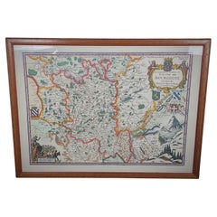
View AllTerritorium Norimbergense - Antique Map of Nürnberg by Janssonius (1645-58)
Located in Langweer, NL
This is an antique map of Nürnberg, titled "Territorium Norimbergense," created by Johannes Janssonius and published between 1645 and 1658. It is a copperplate engraving printed on p...
Category
Antique 1650s Maps
Materials
Paper
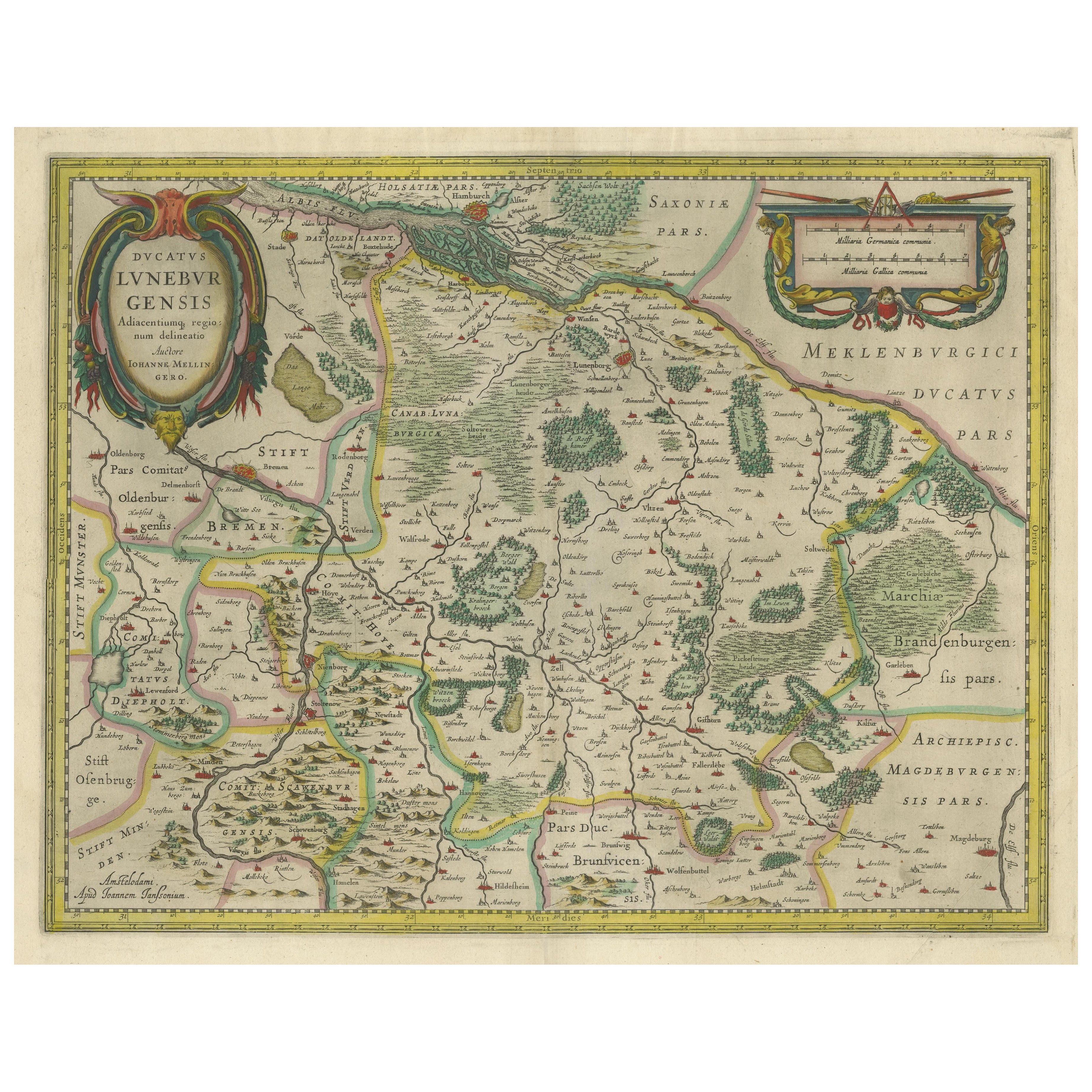
Antique Map of the Duchy of Lüneburg, Lower Saxony, Germany
Located in Langweer, NL
Antique map titled 'Ducatus Luneburgensis (..)'. Map of the Duchy of Lüneburg in Lower Saxony, Germany. Published by J. Janssonius, circa 1664.
Jan Janssonius (also known as Johann ...
Category
Antique Mid-17th Century Maps
Materials
Paper

$515 Sale Price
20% Off
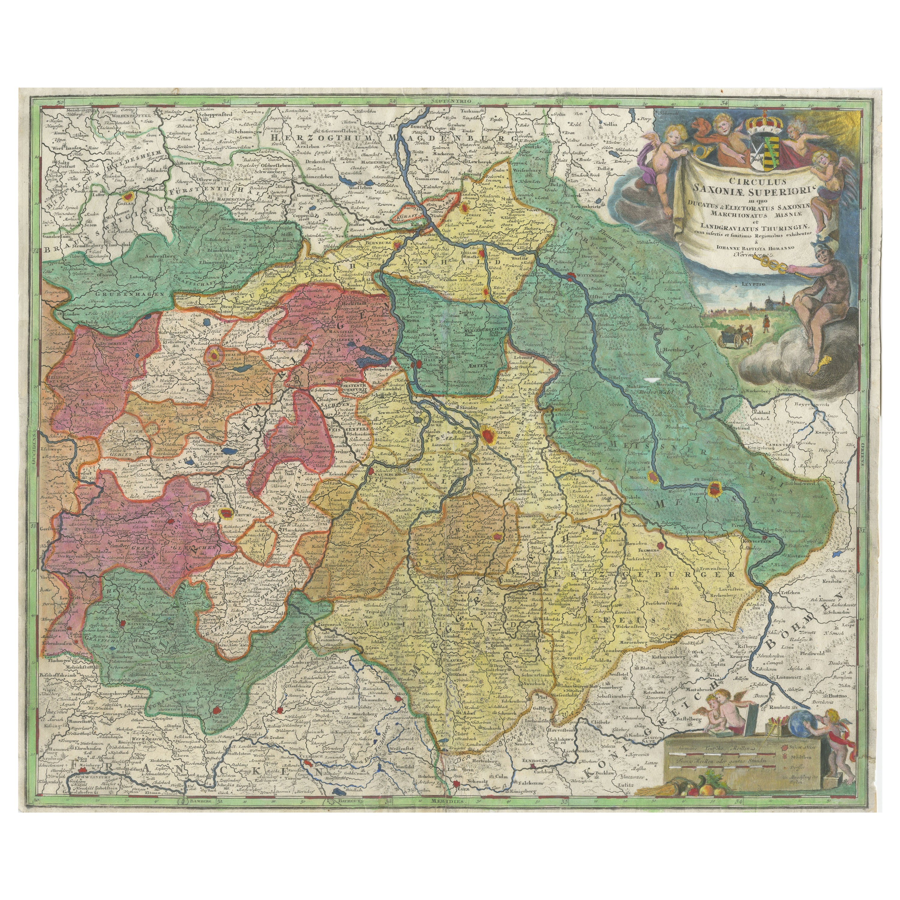
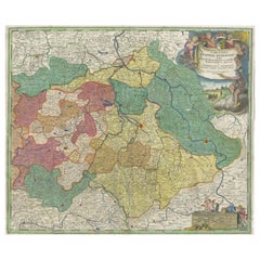
Antique Map of Saxony, Germany
Located in Langweer, NL
Original antique map titled 'Circulus Saxoniae Superioris'. Original antique map of Saxony, Germany. The cities of Leipzig, Freiburg and many others are highlighted in gold. This map originates from 'Atlas Novus Terrarum Orbis...
Category
Antique Early 18th Century Maps
Materials
Paper
$573 Sale Price
20% Off
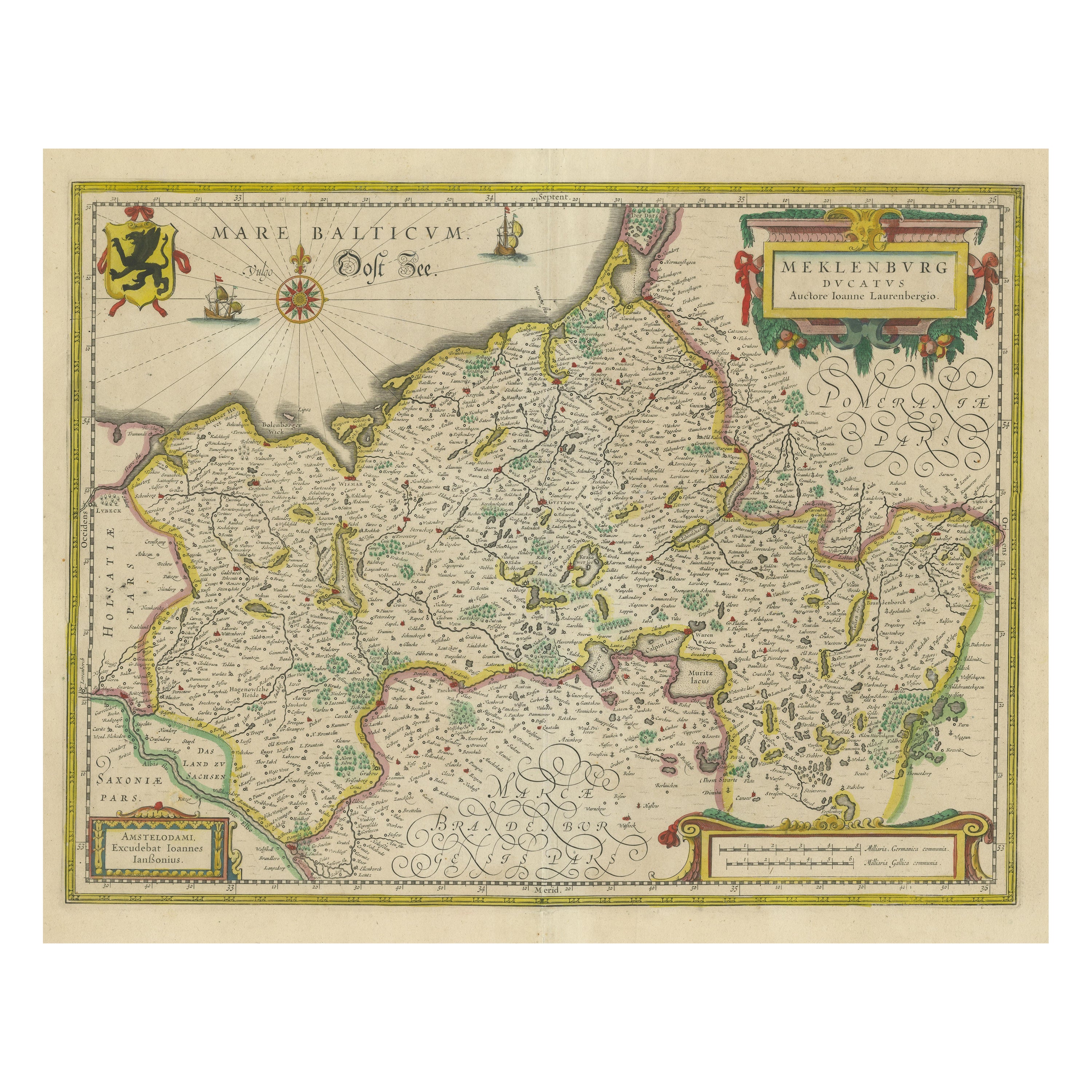
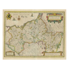
Antique Map of Northern Germany, showing the area of Mecklenburg-Vorpommern
Located in Langweer, NL
Antique map titled 'Meklenburg Ducatus'. Attractive map of northern Germany, showing the area of Mecklenburg-Vorpommern. Published by J. Janssonius, circa 1630.
Jan Janssonius (als...
Category
Antique Mid-17th Century Maps
Materials
Paper
$754 Sale Price
20% Off
Antique Map of Silesia centered on Glogau
Located in Langweer, NL
Antique map titled 'Ducatus Silesiae Glogani vera delineatio'. This decorative map shows the Odra River valley based on the Silesian cartographer, Jonas Scultetus. The map is oriente...
Category
Antique Mid-17th Century Maps
Materials
Paper
$649 Sale Price
20% Off
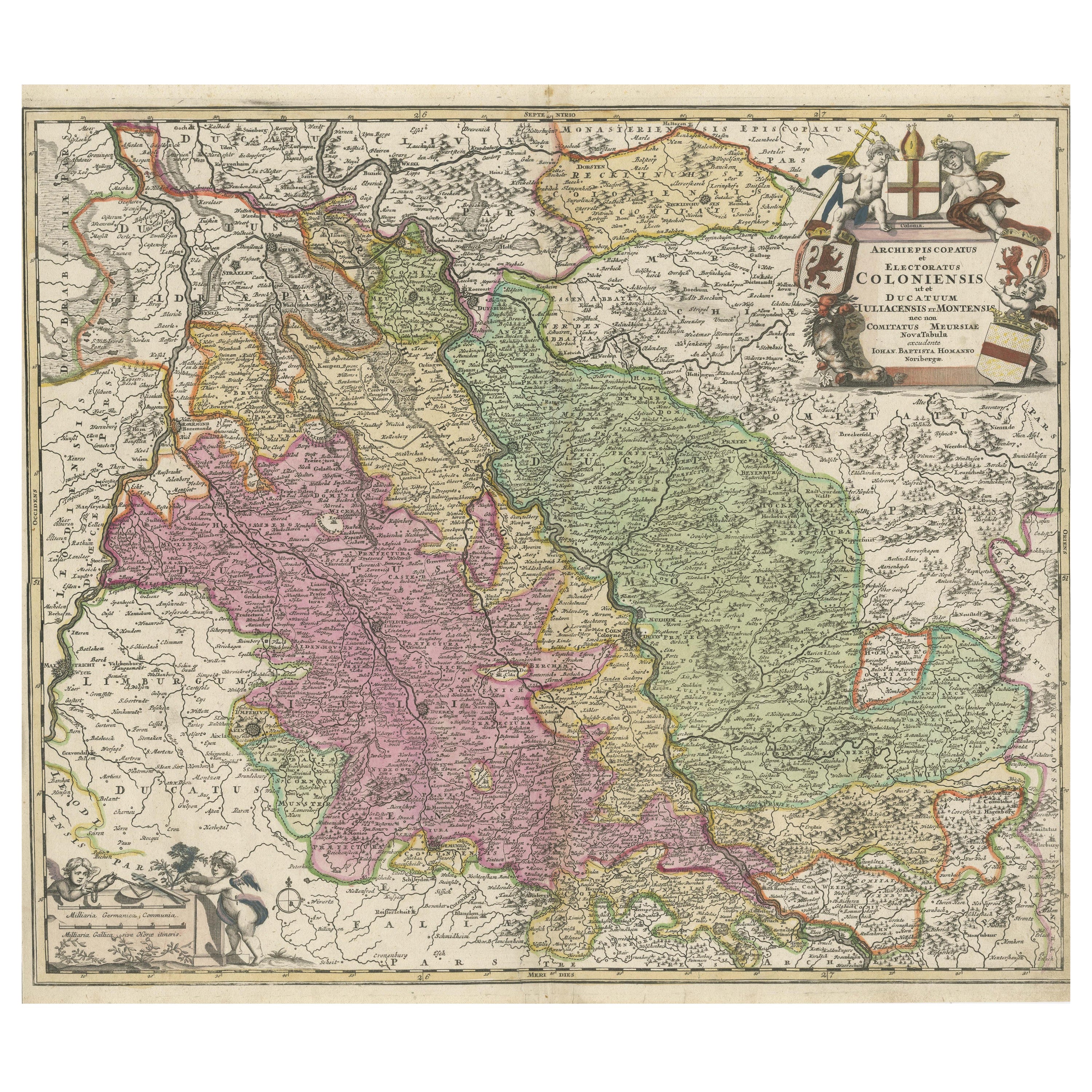
Antique Map of the Rhine centered on Cologne, Germany
Located in Langweer, NL
Antique map titled 'Archiepsiscopatus et Electoratus Coloniensis (..)'. Original antique map of the Rhine river, centered on Cologne, Germany. The Rhine River cuts across this map fr...
Category
Antique Early 18th Century Maps
Materials
Paper

$525 Sale Price
20% Off
You May Also Like
1594 Maurice Bouguereau Map of the Region Limoges, France, Ric0015
Located in Norton, MA
1594 Maurice Bouguereau map of the region Limoges, France, entitled
"Totivs Lemovici et Confinium Pro Uinciarum Quantum ad Dioecefin Lemo Uicenfen Fpectant,"
Hand Colored
Ric0015
Jean IV Le Clerc...
Category
Antique 16th Century Dutch Maps
Materials
Paper

Antique Colored Belgium Map Flandria Gallica Flanders Henricus Hondius
Located in Dayton, OH
Antique hand colored map of Flanders, Belgium, engraved by Henricus Hondius.
Sans frame - 21.25” x 18”.
Category
Antique 19th Century Renaissance Maps
Materials
Paper

1633 Map Entitled "Beauvaisis Comitatus Belova Cium, Ric.0002
Located in Norton, MA
1633 map entitled
"Beauvaisis Comitatus Belova Cium,"
Hand Colored
Ric.0002
Description: Cartographer : - Hondius, Henricus 1587-1638
Artists and Engravers:Jodocus Hondius, one of the most notable engravers of his time. He is known for his work in association with many of the cartographers and publishers prominent at the end of the sixteenth and the beginning of the seventeenth century. A native of Flanders, he grew up in Ghent, apprenticed as an instrument and globe maker and map engraver. In 1584, to escape the religious troubles sweeping the Low Countries at that time, he fled to London where he spent some years before finally settling in Amsterdam about 1593. In the London period he came into contact with the leading scientists and geographers of the day and engraved maps in The Mariner\\\\\\\\\\\\\\\'s Mirrour, the English edition of Waghenaer\\\\\\\\\\\\\\\'s Sea Atlas, as well as others with Pieter van den Keere, his brother-in-law. No doubt his temporary exile in London stood him in good stead, earning him an international reputation, for it could have been no accident that Speed chose Hondius to engrave the plates for the maps in The Theatre of the Empire of Great Britaine in the years between 1605 and 1610. In 1604 Hondius bought the plates of Mercator\\\\\\\\\\\\\\\'s Atlas which, in spite of its excellence, had not competed successfully with the continuing demand for the Ortelius Theatrum Orbis Terrarum. To meet this competition Hondius added about 40 maps to Mercator\\\\\\\\\\\\\\\'s original number and from 1606 published enlarged editions in many languages, still under Mercator\\\\\\\\\\\\\\\'s name but with his own name as publisher. These atlases have become known as the Mercator/Hondius series. The following year the maps were reengraved in miniature form and issued as a pocket Atlas Minor. After the death of Jodocus Hondius the Elder in 1612, work on the two atlases, folio and miniature, was carried on by his widow and sons, Jodocus II and Henricus, and eventually in conjunction with Jan Jansson in Amsterdam.
In all, from 1606 onwards, nearly 50 editions with increasing numbers of maps with texts in the main European languages were printed. Summaries of these issues are given under the entry for Gerard Mercator. Jodocus Hondius the Elder * 1588 Maps in The Mariner\\\\\\\\\\\\\\\'s Mirrour (Waghenaer/Ashley) * 1590 World Map...
Category
Antique 17th Century Dutch Maps
Materials
Paper

1656 Jansson Map Metz Region of France Entitled "Territorium Metense" Ric0014
Located in Norton, MA
1656 Jansson map Metz Region of France entitled "Territorium Metense."
Ric0014
" Authentic" - Map of the historical region surrounding Metz, in Lorraine, France.
Oriented with ...
Category
Antique 17th Century Dutch Maps
Materials
Paper

Vintage 20th Century Engraving of a Map of Duchy of Burgundy and County - 2Y442
Located in Bordeaux, FR
This vintage 20th-century engraving features a detailed map of the Duchy of Burgundy and the County of Bresse, making it an elegant and historical addition to any collection. Measuri...
Category
20th Century Antiquities
Materials
Wood, Paper
1592 Abraham Ortelius Map "Lorraine: Lotharingiae Nova Descripti, Ric.A005
Located in Norton, MA
1592 Abraham Ortelius map entitled
"Lorraine: Lotharingiae Nova Descripti
Ric.a005
Description: Ortelius is best known for producing the atlas from which this map comes from, "...
Category
Antique 16th Century Dutch Maps
Materials
Paper

More Ways To Browse
Holland And Son
Russia Globe
Salt Lake City Used Furniture
World Map Copper
Sterling Silver Dinner Sets
England Antique Plates
Black Scandinavian Modern Dining Chairs
Louis French Tables Fluted
Used Pianos Pianos
Earth Toned Rug
United Chair Company
Vintage Brown Bottles
Mid Century Modern Danish Teak Dining Tables
Mid Century Wrought Iron Chairs
Shirvan Rugs
Antique Carved Wood Chair
Brown Sheepskin Chair
Gold Modern Coffee Table