Items Similar to Antique Map of Delfland, Schieland and Islands of Zuid-Holland, the Netherlands


Want more images or videos?
Request additional images or videos from the seller
1 of 6
Antique Map of Delfland, Schieland and Islands of Zuid-Holland, the Netherlands
$658.52
$823.1420% Off
£486.79
£608.4820% Off
€552
€69020% Off
CA$913.40
CA$1,141.7420% Off
A$995.80
A$1,244.7520% Off
CHF 526.16
CHF 657.7020% Off
MX$12,246
MX$15,307.5120% Off
NOK 6,542.40
NOK 8,17820% Off
SEK 6,158.80
SEK 7,698.5020% Off
DKK 4,203.20
DKK 5,253.9920% Off
About the Item
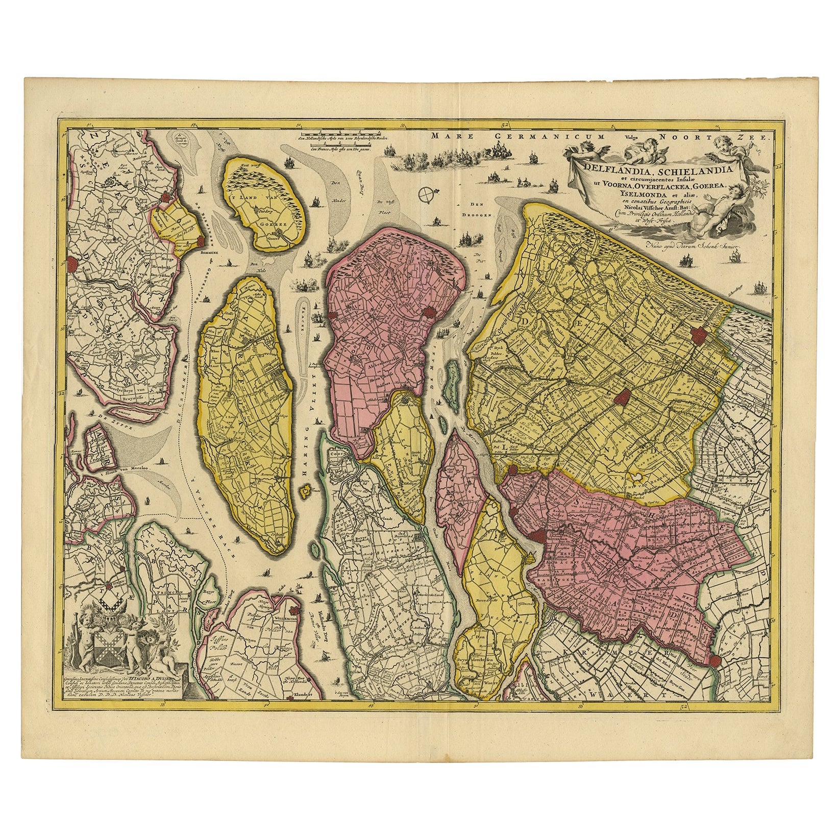
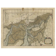
Antique map titled 'Delflandia, Schielandia, et Insulae (..)'. Original antique map of Delfland, Schieland and islands of Zuid-Holland, the Netherlands. The 'Zuid-Hollandse Eilanden' include Rozenburg, IJsselmonde, Goeree, Overflakke and others. Published by W. Blaeu, circa 1635.
Willem Janszoon Blaeu (1571-1638) was a prominent Dutch geographer and publisher. Born the son of a herring merchant, Blaeu chose not fish but mathematics and astronomy for his focus. He studied with the famous Danish astronomer Tycho Brahe, with whom he honed his instrument and globe making skills. Blaeu set up shop in Amsterdam, where he sold instruments and globes, published maps, and edited the works of intellectuals like Descartes and Hugo Grotius. In 1635, he released his atlas, Theatrum Orbis Terrarum, sive, Atlas novus.
- Dimensions:Height: 19.49 in (49.5 cm)Width: 23.12 in (58.7 cm)Depth: 0.02 in (0.5 mm)
- Materials and Techniques:
- Period:Mid-17th Century
- Date of Manufacture:c.1635
- Condition:Original/contemporary hand coloring. Original folding line. Shows some wear and soiling. Light staining in margins. French text on verso. Please study image carefully.
- Seller Location:Langweer, NL
- Reference Number:Seller: BG-135531stDibs: LU3054336086882
About the Seller
5.0
Recognized Seller
These prestigious sellers are industry leaders and represent the highest echelon for item quality and design.
Platinum Seller
Premium sellers with a 4.7+ rating and 24-hour response times
Established in 2009
1stDibs seller since 2017
2,620 sales on 1stDibs
Typical response time: <1 hour
- ShippingRetrieving quote...Shipping from: Langweer, Netherlands
- Return Policy
Authenticity Guarantee
In the unlikely event there’s an issue with an item’s authenticity, contact us within 1 year for a full refund. DetailsMoney-Back Guarantee
If your item is not as described, is damaged in transit, or does not arrive, contact us within 7 days for a full refund. Details24-Hour Cancellation
You have a 24-hour grace period in which to reconsider your purchase, with no questions asked.Vetted Professional Sellers
Our world-class sellers must adhere to strict standards for service and quality, maintaining the integrity of our listings.Price-Match Guarantee
If you find that a seller listed the same item for a lower price elsewhere, we’ll match it.Trusted Global Delivery
Our best-in-class carrier network provides specialized shipping options worldwide, including custom delivery.More From This Seller
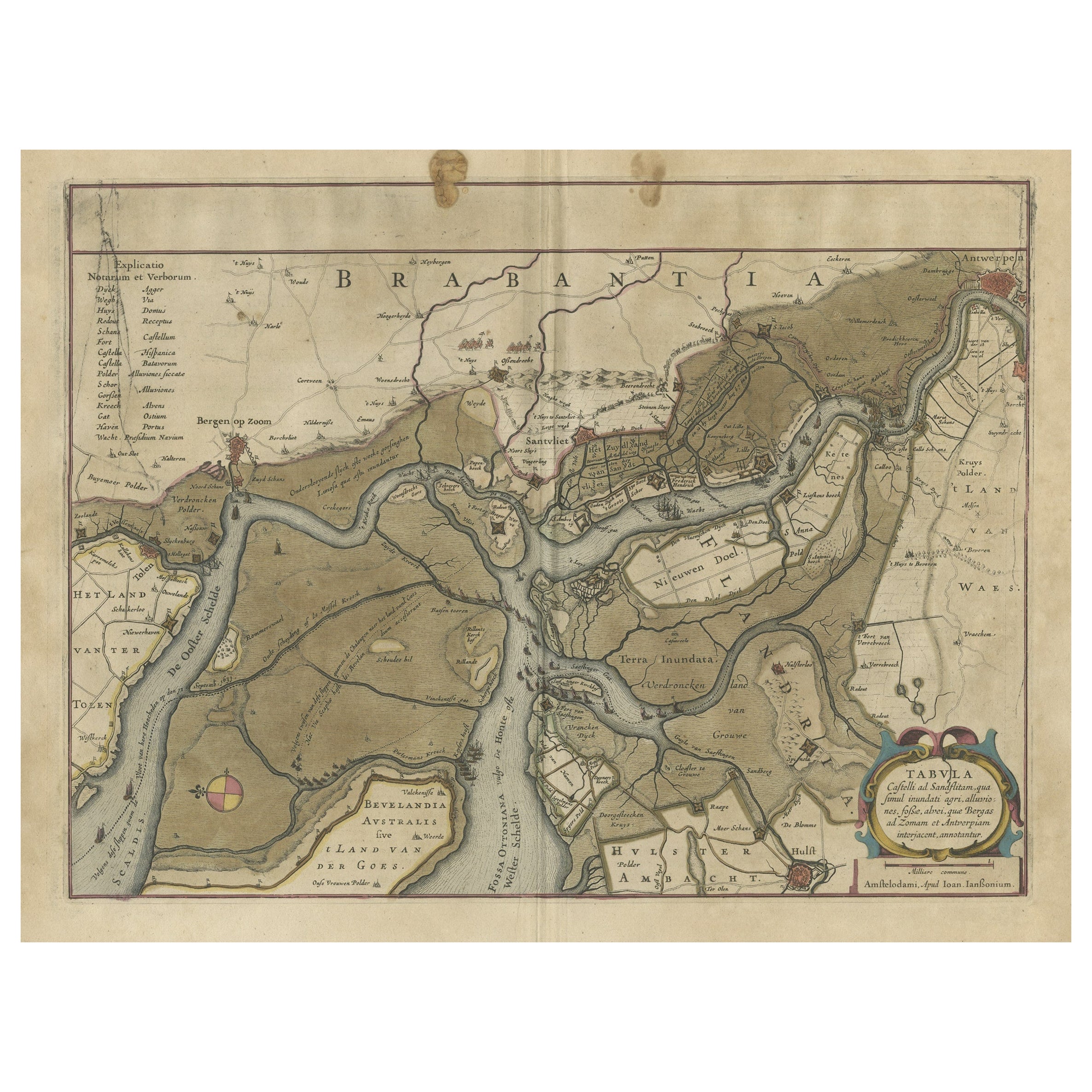
View AllAntique Map of the region between Bergen op Zoom, Sandvliet, Hulst and Antwerp
Located in Langweer, NL
Original antique map titled 'Tabula Castelli ad Sandflitam (..)'. Detailed map of the region between Bergen op Zoom, Sandvliet, Hulst and Antwerp. Published by J. Janssonius, circa 1...
Category
Antique Mid-17th Century Maps
Materials
Paper
$515 Sale Price
20% Off
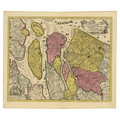
Detailed Map of Southern Holland, Incl the Hague, Rotterdam, Delft, Gouda, c1680
Located in Langweer, NL
Antique map titled 'Delflandia, Schielandia et circumjacentes Insulae ut Voorna, Overflackea, Goerea, Yselmonda et aliae.'
Detailed map of Southern Holland, which includes the ci...
Category
Antique 1680s Maps
Materials
Paper
$969 Sale Price
34% Off
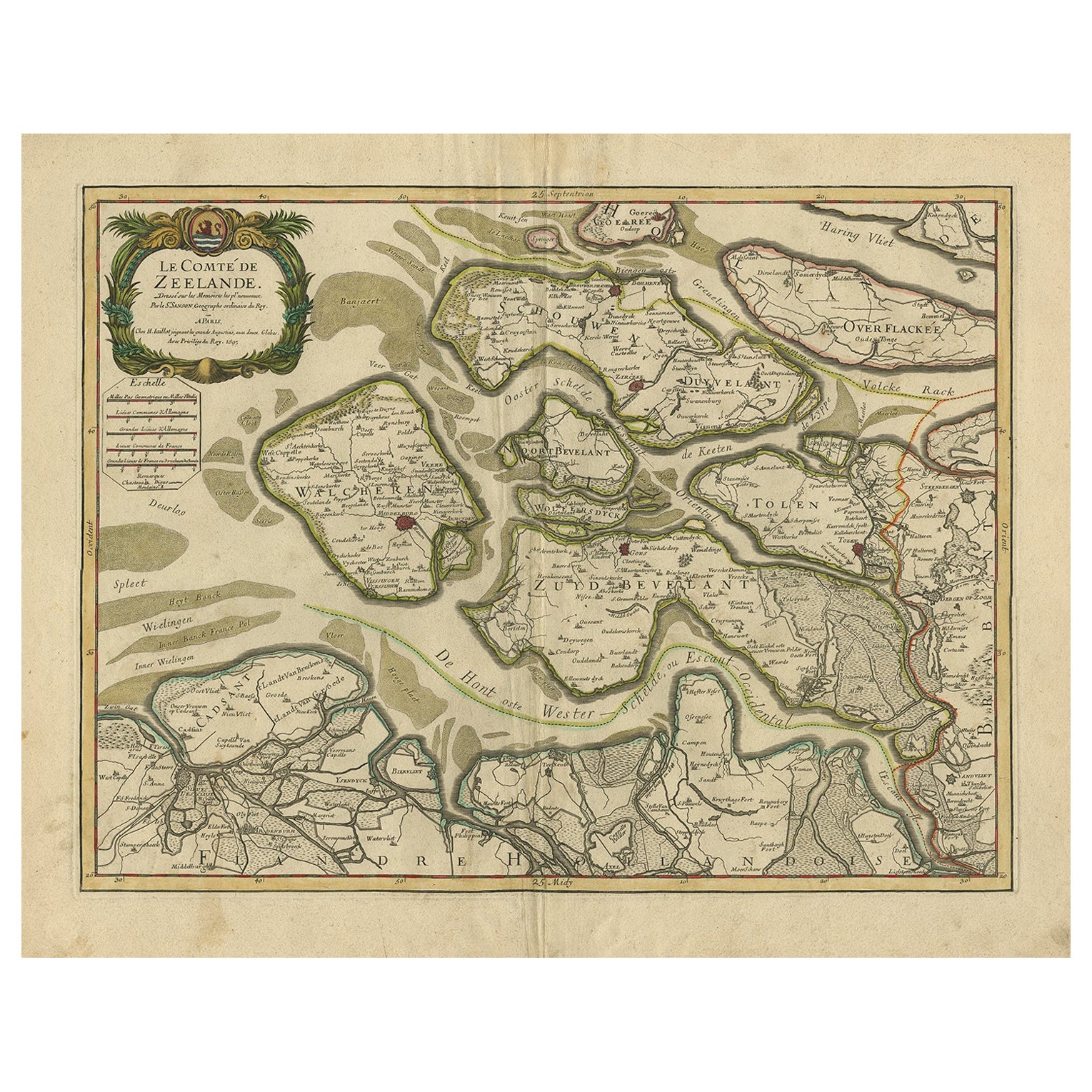
Antique Map of Zeeland, The Netherlands, by Jaillot, 1693
Located in Langweer, NL
Antique map titled 'Le Comte de Zeelande (..).' Detailed map of the province of Zeeland, The Netherlands. Details shown include fortified towns, roads, sandbanks and marshlands. Base...
Category
Antique 17th Century Maps
Materials
Paper

$849 Sale Price
20% Off
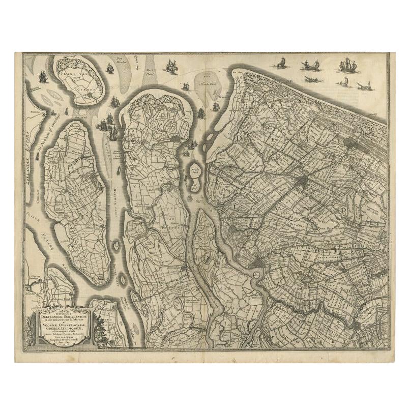
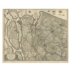
Antique Map of Delfland and Schieland by Hondius, c.1630
Located in Langweer, NL
Antique map titled ‘Novissima Delflandiae, Schielandiae et circumiacentium insularum ut Voornae, Overflackeae, Goereae, Iselmondae (..)’. Engraving of Delfland and Schieland. Designe...
Category
Antique 17th Century Maps
Materials
Paper
$787 Sale Price
20% Off
Antique Map of the Province of Friesland in The Netherlands, 1718
Located in Langweer, NL
Antique map titled 'Frisiae Dominium vernacule Friesland (..)'.
Original antique map of Friesland, the Netherlands. Originates from 'Uitbeelding van de Heerlijkheid van Friesland...
Category
Antique 18th Century Maps
Materials
Paper

$715 Sale Price
20% Off
Antique Map of Friesland by De Wit, c.1690
Located in Langweer, NL
Antique map titled 'Tabula Comitatus Frisiae'.
Old map of the province of Friesland, the Netherlands. With a small inset map of the Wadden area. Third state of the map by Schotan...
Category
Antique 17th Century Maps
Materials
Paper

$782 Sale Price
20% Off
You May Also Like
1752 Vaugoundy Map of Flanders : Belgium, France, and the Netherlands, Ric.a002
Located in Norton, MA
Large Vaugoundy Map of Flanders:
Belgium, France, and the Netherlands
Colored -1752
Ric.a002
Description: This is a 1752 Didier Robert de Vaugondy map of Flanders. The map de...
Category
Antique 17th Century Unknown Maps
Materials
Paper

Original Antique Map or City Plan of Amsterdam, Netherlands. Circa 1835
Located in St Annes, Lancashire
Nice map of Amsterdam
Drawn and engraved by J.Dower
Published by Orr & Smith. C.1835
Unframed.
Free shipping
Category
Antique 1830s English Maps
Materials
Paper

1643 Willem&Joan Blaeu Map NW Flanders "Flandriae Teutonicae Pars Prientalior
Located in Norton, MA
1643 Willem and Joan Blaeu map of northwest Flanders, entitled
"Flandriae Teutonicae Pars Prientalior,"
Ric0012
" Authentic" - Map of the northwest Fl...
Category
Antique 17th Century Dutch Maps
Materials
Paper

Rare Original Map of New Amsterdam (New York) – “Restitutio”, ca. 1674 –
Located in Dronten, NL
An exceptionally rare and original 17th-century engraving of New Amsterdam, now New York City, published by the renowned Amsterdam cartographer Carel (Carolus) Allard around 1674. Kn...
Category
Antique 17th Century Dutch Maps
Materials
Paper

1633 Map "La Souverainete De Sedan Et De Raucourt, Et La Prevoste Ric0011
Located in Norton, MA
1653 map entitled
"La Souverainete de Sedan et de Raucourt, et la Prevoste de Doncheri,"
Ric0011
Description:
Lovely map centered on Sedan and Doncheri and the Meuze River fr...
Category
Antique 17th Century Dutch Maps
Materials
Paper

Antique Colored Belgium Map Flandria Gallica Flanders Henricus Hondius
Located in Dayton, OH
Antique hand colored map of Flanders, Belgium, engraved by Henricus Hondius.
Sans frame - 21.25” x 18”.
Category
Antique 19th Century Renaissance Maps
Materials
Paper

$280 Sale Price
20% Off
More Ways To Browse
Holland And Son
Irish Antiques 16th Century
Ithaca Antique Map
Leonard Jones
Russia Globe
Salt Lake City Used Furniture
World Map Copper
Green French Glass
Mid Century Modern Wicker Chair
Mid-Century Modern Wicker Chairs
Curved Back Mid Century Dining Chairs
Glass Stopper
Stretcher Tables
Antique French Lithographs
M Table
Antique Sultanabad Carpets
China Chair
English Antique Desks