Items Similar to Antique Map of the Island of Tahiti, Polynesia, 1803


Want more images or videos?
Request additional images or videos from the seller
1 of 10
Antique Map of the Island of Tahiti, Polynesia, 1803
$532.05
$1,064.1050% Off
£393.88
£787.7550% Off
€445
€89050% Off
CA$736.22
CA$1,472.4550% Off
A$811.67
A$1,623.3450% Off
CHF 424.64
CHF 849.2850% Off
MX$9,957.67
MX$19,915.3450% Off
NOK 5,345.36
NOK 10,690.7350% Off
SEK 4,998.76
SEK 9,997.5250% Off
DKK 3,389.74
DKK 6,779.4750% Off
About the Item
Antique map Tahiti titled 'Kaart van het Eiland Otahiti'.
Antique map of the Island of Tahiti, Polynesia. Originates from 'Reizen Rondom de Waereld door James Cook (..)'.
Artists and Engravers: Translated by J.D. Pasteur. Published by Honkoop, Allart en Van Cleef.
Condition: Very good, general age-related toning. Please study image carefully.
- Dimensions:Height: 11.42 in (29 cm)Width: 18.51 in (47 cm)Depth: 0 in (0.02 mm)
- Materials and Techniques:Paper,Engraved
- Place of Origin:
- Period:
- Date of Manufacture:1803
- Condition:Condition: Very good, general age-related toning. Please study image carefully.
- Seller Location:Langweer, NL
- Reference Number:Seller: BG-11487-25 1stDibs: LU3054326767642
About the Seller
5.0
Recognized Seller
These prestigious sellers are industry leaders and represent the highest echelon for item quality and design.
Platinum Seller
Premium sellers with a 4.7+ rating and 24-hour response times
Established in 2009
1stDibs seller since 2017
2,613 sales on 1stDibs
Typical response time: <1 hour
- ShippingRetrieving quote...Shipping from: Langweer, Netherlands
- Return Policy
Authenticity Guarantee
In the unlikely event there’s an issue with an item’s authenticity, contact us within 1 year for a full refund. DetailsMoney-Back Guarantee
If your item is not as described, is damaged in transit, or does not arrive, contact us within 7 days for a full refund. Details24-Hour Cancellation
You have a 24-hour grace period in which to reconsider your purchase, with no questions asked.Vetted Professional Sellers
Our world-class sellers must adhere to strict standards for service and quality, maintaining the integrity of our listings.Price-Match Guarantee
If you find that a seller listed the same item for a lower price elsewhere, we’ll match it.Trusted Global Delivery
Our best-in-class carrier network provides specialized shipping options worldwide, including custom delivery.More From This Seller
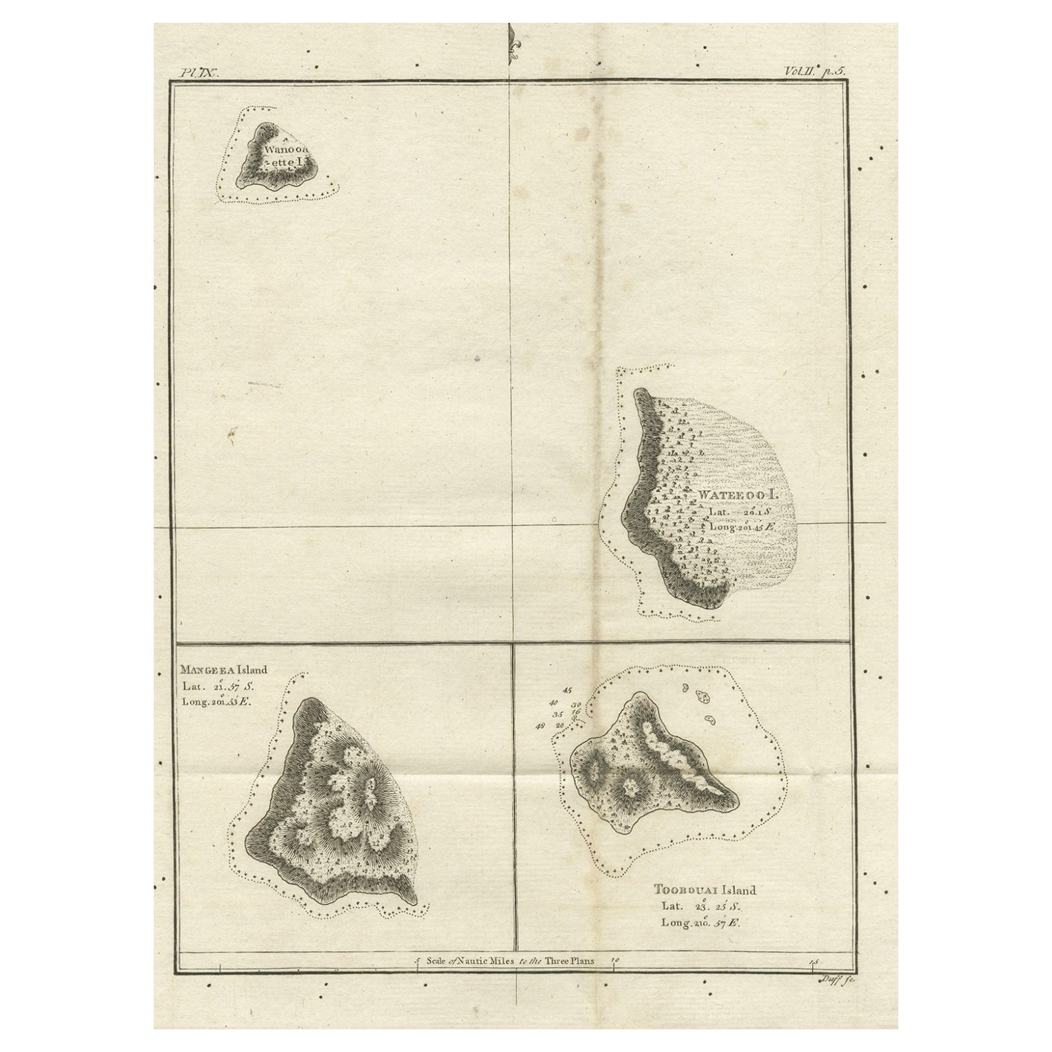
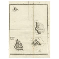
View AllOld Map of the Cook Islands Takutea, Atiu, Mangaiac and Tubuai, Polynesia, 1781
Located in Langweer, NL
Antique map titled 'Mangeea Island, Toobouai Island (..)'. Map of three of the Cook Islands: Wanooaette [i.e. Takutea] Island, Wateeoo [i.e. Tui or Atiu] ...
Category
Antique 18th Century Maps
Materials
Paper
$124 Sale Price
20% Off
Antique Map of Western Polynesia, 1849
Located in Langweer, NL
Antique map titled 'Ost-Polynesien'. Detailed map of the western Pacific extending from the Celebes to Samoa and including part of Australia. Insets of...
Category
Antique Mid-19th Century Maps
Materials
Paper

$167 Sale Price
30% Off
Antique Map of Eastern Polynesia, 1849
Located in Langweer, NL
Antique map titled 'Ost-Polynesien'. Interesting variant issue, with large detailed insets top right of Hawaii volcanos near Kilauea. Insets lower right of Honolulu harbour, island o...
Category
Antique Mid-19th Century Maps
Materials
Paper

$167 Sale Price
30% Off
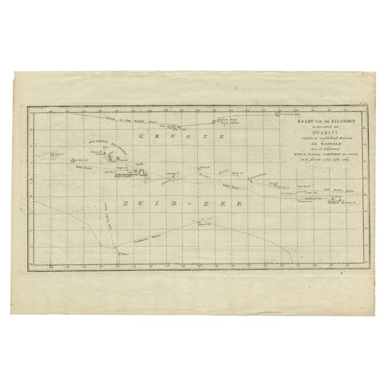
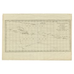
Antique Map of French Polynesia by Cook Showing His Route, 1803
Located in Langweer, NL
Antique map Tahiti titled 'Kaart van de Eilanden in den omtrek van Otahiti (..)'. Antique map of French Polynesia with the tracks around the island of Tahiti by Captain Byron, Wallis...
Category
Antique 19th Century Maps
Materials
Paper
$454 Sale Price
20% Off
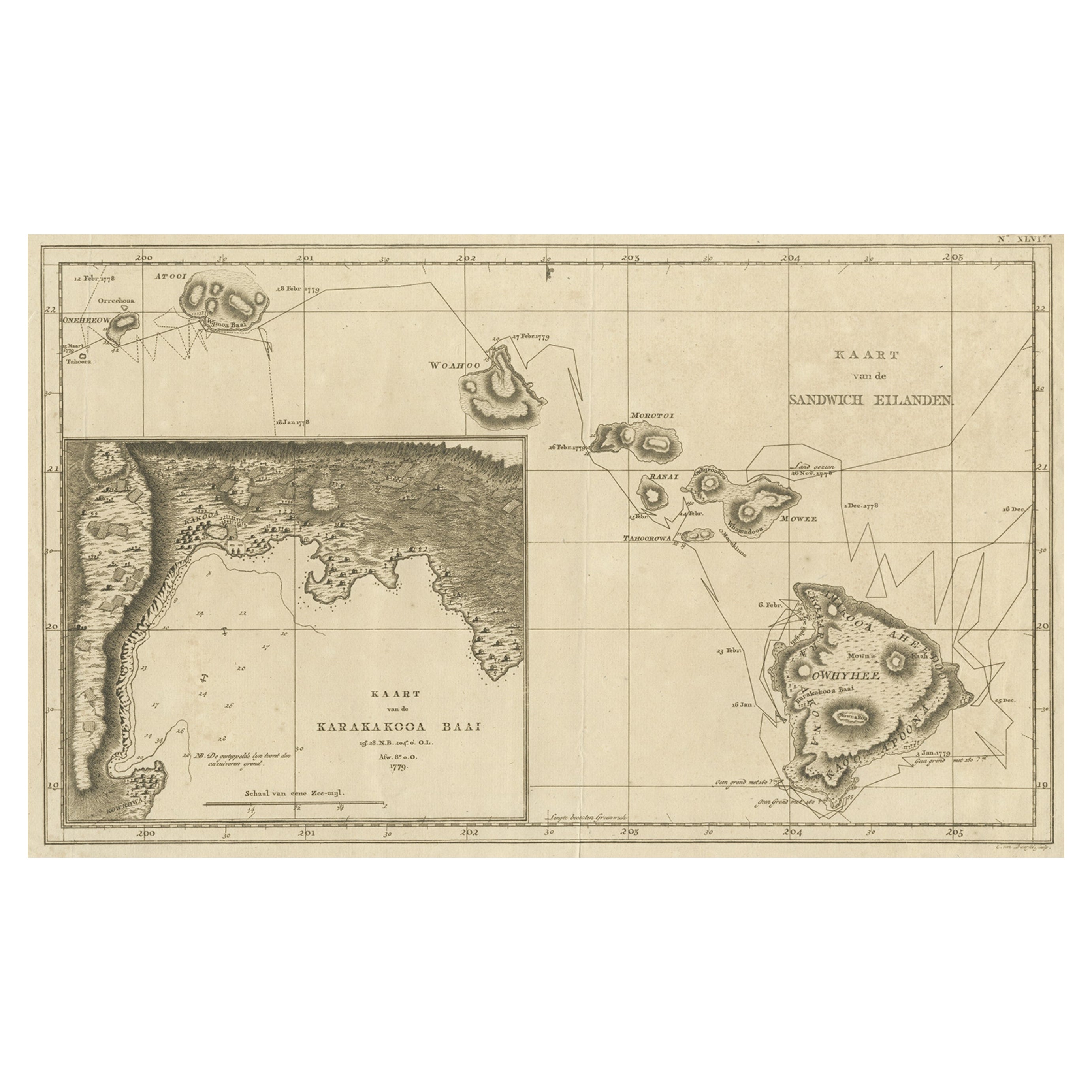
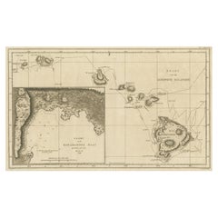
Map of the Hawaiian Islands with a Large Inset of Karakakooa Bay, 1803
Located in Langweer, NL
Antique map titled 'Kaart van de Sandwich Eilanden'.
Map of the Hawaiian Islands with a large inset of Karakakooa Bay, including soundings and anchorages. Originates from 'Reizen R...
Category
Antique Early 1800s Maps
Materials
Paper
$2,152 Sale Price
20% Off
Free Shipping
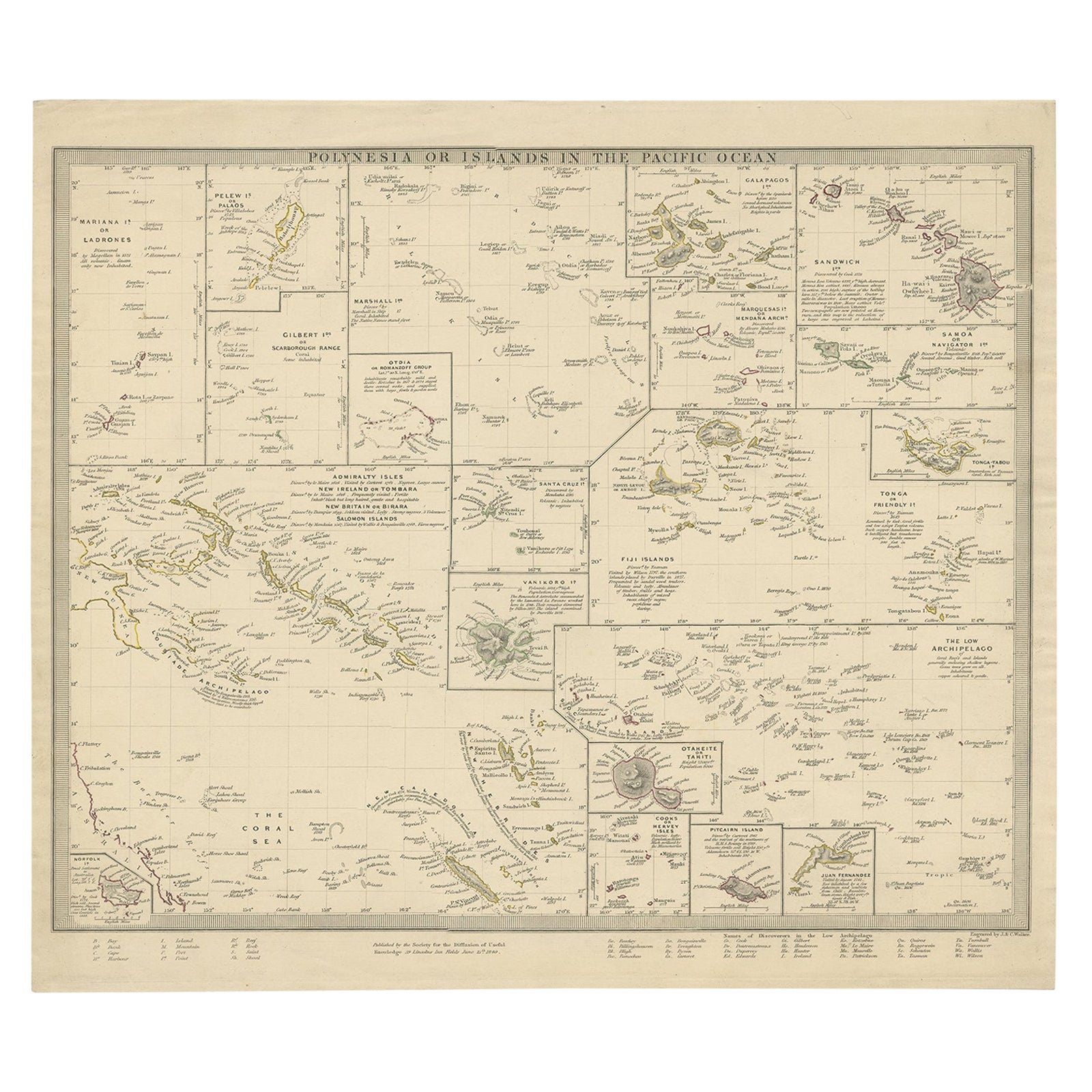
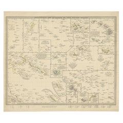
Antique Map of Polynesia with Details of Many Islands, 1840
Located in Langweer, NL
Antique map titled 'Polynesia or Islands in the Pacific Ocean'.
This map depicts various islands including the Lousiade Archipelago, Tahiti, Pitcairn Island, Juan Fernandez, The lo...
Category
Antique 19th Century Maps
Materials
Paper
You May Also Like
Captain Cook's Exploration of Tahiti: 18th C. Hand-colored Map by Bellin
By Jacques-Nicolas Bellin
Located in Alamo, CA
This beautiful 18th century hand-colored copper plate engraved map is entitled "Carte de l'Isle de Taiti, par le Lieutenant J. Cook" was created by Jacques Nicolas Bellin and publish...
Category
Late 18th Century Landscape Prints
Materials
Engraving

Original Antique Map of Hawaii And Adjacent Islands. C.1900
Located in St Annes, Lancashire
Fabulous map of Hawaii. With a vignette of Honolulu
Original color.
Engraved and printed by the George F. Cram Company, Indianapolis.
Published, C.1900.
Unframed.
Free shipping.
Category
Antique 1890s American Maps
Materials
Paper

Large Original Vintage Map of The Pacific Islands Including Hawaii
Located in St Annes, Lancashire
Great map of The Pacific Islands
Unframed
Original color
By John Bartholomew and Co. Edinburgh Geographical Institute
Published, circa 1...
Category
Vintage 1920s British Maps
Materials
Paper

Original Antique Map of US Possessions In The Pacific Ocean, C.1900
Located in St Annes, Lancashire
Fabulous map of US possessions in the Pacific Ocean
Original color.
Engraved and printed by the George F. Cram Company, Indianapolis.
Published, C.1900.
Unframed.
Free shipping.
Category
Antique 1890s American Maps
Materials
Paper

Large Original Antique Map of The Leeward Islands. 1894
Located in St Annes, Lancashire
Superb Antique map of The Leeward Islands
Published Edward Stanford, Charing Cross, London 1894
Original colour
Good condition
Unframed.
Free shipping
Category
Antique 1890s English Maps
Materials
Paper

Large Original Antique Map of The Canary Islands. 1894
Located in St Annes, Lancashire
Superb Antique map of The Canary Islands
Published Edward Stanford, Charing Cross, London 1894
Original colour
Good condition
Unframed.
Free shipping
Category
Antique 1890s English Maps
Materials
Paper

More Ways To Browse
Solomons Temple
Antique Maps Caribbean Islands
Antique Wine Maps
Map Of Jamaica
Used Furniture Wisconsin
Antique Furniture Michigan
Antique Maps Of Cape Of Good Hope
Antique Maps Of Texas
Antique Virginia Furniture
Mughal Map
American West Antiques
Antique Furniture Brunswick
Antique Map Ceylon
Antique Map Of The Philippines
Antique Mississippi Map
Celestial Map
Nevada Antique Map
17th Century American Furniture