Items Similar to Antique Map of the Region of Languedoc, Foix, Roussillon and Rouergue by Zatta

Want more images or videos?
Request additional images or videos from the seller
1 of 5
Antique Map of the Region of Languedoc, Foix, Roussillon and Rouergue by Zatta
$433.20
£320.72
€360
CA$599.80
A$654.84
CHF 343.31
MX$7,953.29
NOK 4,287.33
SEK 4,048.39
DKK 2,740.76
About the Item
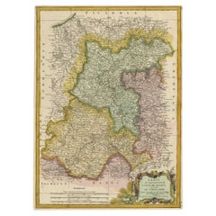
Antique map titled 'Li Governi di Linguadoca, di Foix e di Rossiglione con il Rouergue'. Old map of France showing the regions of Languedoc, Foix, Roussillon and Rouergue. This map originates from 'Atlante Novissimo, illustrato ed accresciuto sulle osservazioni, e scoperte fatte dai piu' celebri e piu' recenti geografi' by A. Zatta.
Artists and Engravers: Antonio Zatta (active 1757-1797) was the most prominent Italian map publisher of the late 18th and early 19th century. His firm, based in Venice, produced maps that mark an important transition from 18th to 19th century cartographic styles.
Condition: Very good, general age-related toning. Original/contemporary hand coloring. Please study image carefully.
Date: 1779
Overall size: 38 x 52.5 cm.
Image size: 32 x 40 cm.
We sell original antique maps to collectors, historians, educators and interior decorators all over the world. Our collection includes a wide range of authentic antique maps from the 16th to the 20th centuries. Buying and collecting antique maps is a tradition that goes back hundreds of years. Antique maps have proved a richly rewarding investment over the past decade, thanks to a growing appreciation of their unique historical appeal. Today the decorative qualities of antique maps are widely recognized by interior designers who appreciate their beauty and design flexibility. Depending on the individual map, presentation, and context, a rare or antique map can be modern, traditional, abstract, figurative, serious or whimsical. We offer a wide range of authentic antique maps for any budget.
- Creator:Antonio Zatta (Artist)
- Dimensions:Height: 20.67 in (52.5 cm)Width: 14.97 in (38 cm)Depth: 0 in (0.01 mm)
- Materials and Techniques:
- Period:
- Date of Manufacture:1779
- Condition:Condition: Very good, general age-related toning. Original/contemporary hand coloring. Please study image carefully.
- Seller Location:Langweer, NL
- Reference Number:Seller: BG-12057-11stDibs: LU3054327830202
About the Seller
5.0
Recognized Seller
These prestigious sellers are industry leaders and represent the highest echelon for item quality and design.
Platinum Seller
Premium sellers with a 4.7+ rating and 24-hour response times
Established in 2009
1stDibs seller since 2017
2,641 sales on 1stDibs
Typical response time: <1 hour
- ShippingRetrieving quote...Shipping from: Langweer, Netherlands
- Return Policy
Authenticity Guarantee
In the unlikely event there’s an issue with an item’s authenticity, contact us within 1 year for a full refund. DetailsMoney-Back Guarantee
If your item is not as described, is damaged in transit, or does not arrive, contact us within 7 days for a full refund. Details24-Hour Cancellation
You have a 24-hour grace period in which to reconsider your purchase, with no questions asked.Vetted Professional Sellers
Our world-class sellers must adhere to strict standards for service and quality, maintaining the integrity of our listings.Price-Match Guarantee
If you find that a seller listed the same item for a lower price elsewhere, we’ll match it.Trusted Global Delivery
Our best-in-class carrier network provides specialized shipping options worldwide, including custom delivery.More From This Seller
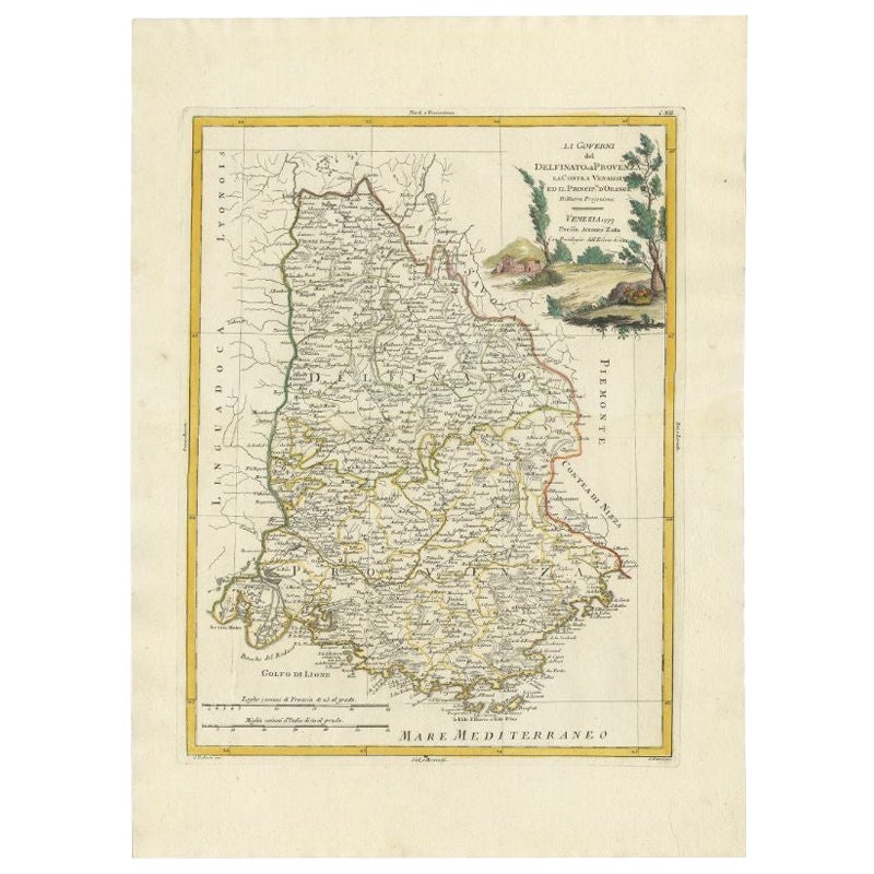
View AllAntique Map of the Region of Dauphiné by Zatta, 1779
Located in Langweer, NL
Antique map titled 'Li Governi del Delfinato e di Provenza la Contea Venaissin ed il Princie d'Orange'. Old map of France showing the province of Dauphiné. This map originates from '...
Category
Antique 18th Century Maps
Materials
Paper
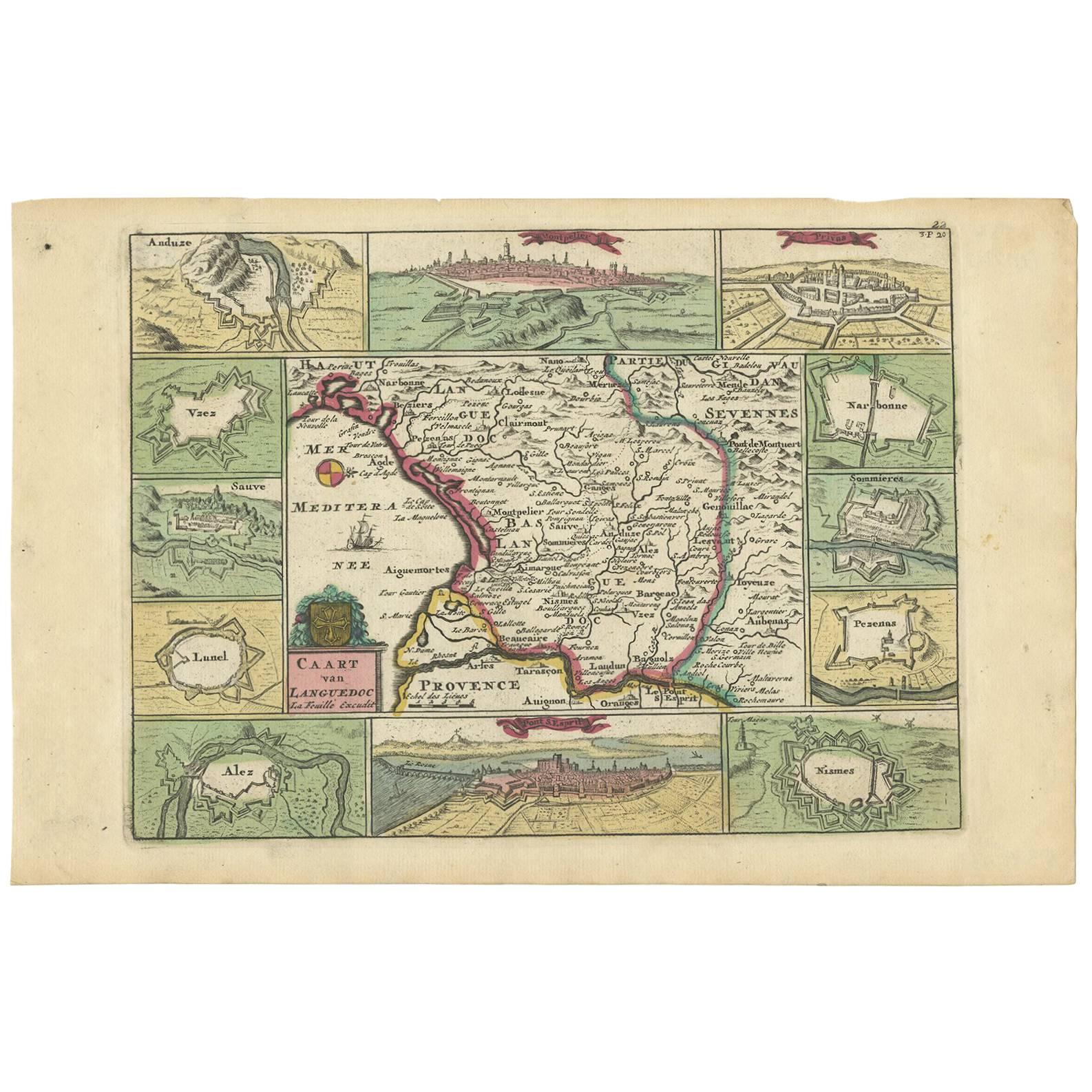
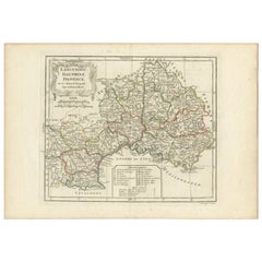
Antique Map of the Languedoc Region 'France' by D. Weege, 1753
Located in Langweer, NL
Antique map titled 'Caart van Languedoc'. Map of the Languedoc-Rousillion region in Southern France. Flanked by miniature plans and views of cities of the region like Montpellier, N...
Category
Antique Mid-18th Century Maps
Materials
Paper
$255 Sale Price
20% Off
Antique Map of the Artois Region 'France' by F. de Wit, circa 1680
Located in Langweer, NL
Antique map titled 'Tabula Comitatus Artesiae emendata'. Large map of the Artois region, France. Published by F. de Wit, circa 1680.
Category
Antique Late 17th Century Maps
Materials
Paper

$518 Sale Price
25% Off
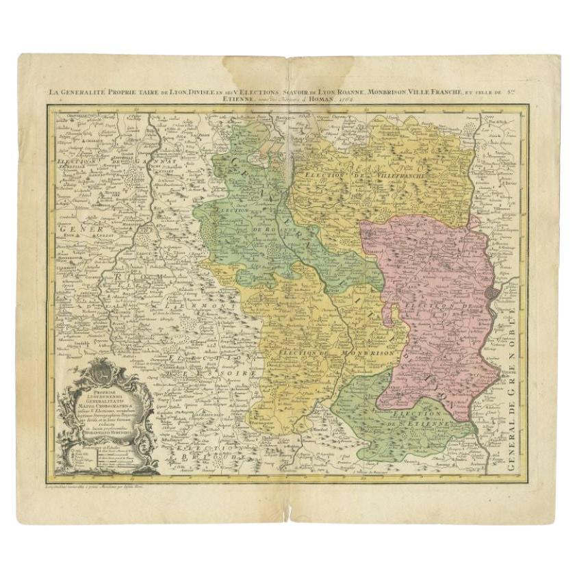
Antique Map of the Beaujolais Region by Homann Heirs, 1762
Located in Langweer, NL
Antique map titled 'La Generalite Proprie Taire De Lyon (..) - Propriae Lugudunensis Generalitatis (..)'. Detailed regional map of the Beaujolais region including the cities of Lyon,...
Category
Antique 18th Century Maps
Materials
Paper
$303 Sale Price
20% Off
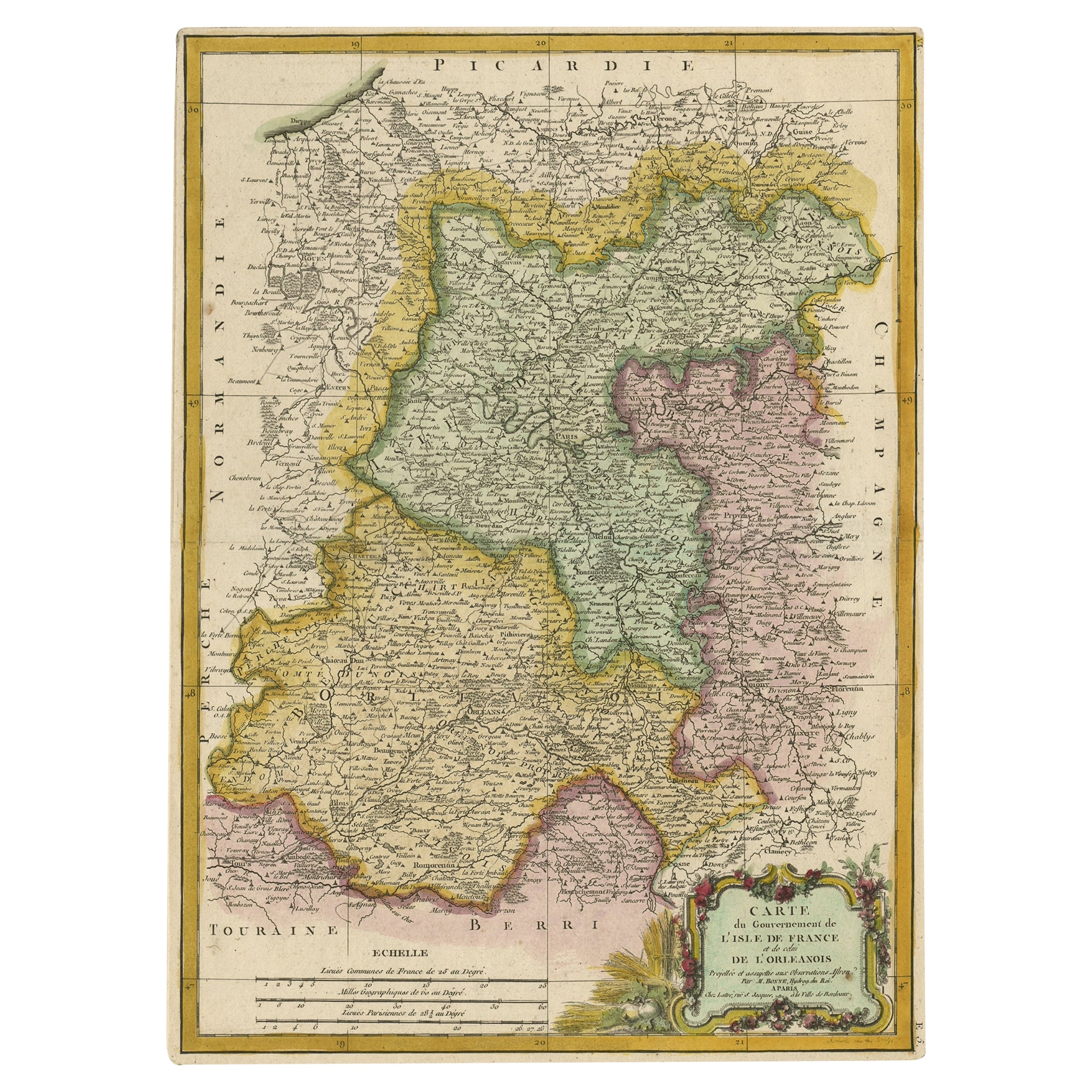
Decorative Rare Map of the French Regions of Isle De France and Orleans, ca.1780
Located in Langweer, NL
Antique map titled 'Carte du Gouvernment de L'Isle de France et de edlui de L'Orleanois (..).'
A fine example of Rigobert Bonne's c. 1780 decorative map of the French regions of ...
Category
Antique 1780s Maps
Materials
Paper
$664 Sale Price
20% Off
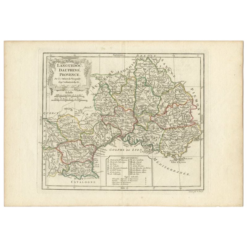
Antique Map of Southeastern France by Vaugondy, c.1790
Located in Langweer, NL
"Antique map titled 'Languedoc, Dauphiné, Province'. Beautiful antique map of Southeastern France with decorative cartouche. Map includes topographical detail as well as a reference ...
Category
Antique 18th Century Maps
Materials
Paper
$154 Sale Price
20% Off
You May Also Like
1771 Bonne Map of Poitou, Touraine and Anjou, France, Ric.a015
Located in Norton, MA
1771 Bonne Map of Poitou,
Touraine and Anjou, France
Ric.a015
1771 Bonne map of Potiou, Touraine and Anjou entitled "Carte des Gouvernements D'Anjou et du Saumurois, de la Touraine, du Poitou,du Pays d'aunis, Saintonge?Angoumois,"
Carte des gouvernements d'Anjou et du Saumurois, de la Touraine, du Poitou, du Pays d'Aunis, Saintonge-Angoumois. Projettee et assujettie au ciel par M. Bonne, Hyd. du Roi. A Paris, Chez Lattre, rue St. Jacques a la Ville de Bord(ea)ux. Avec priv. du Roi. 1771. Arrivet inv. & sculp., Atlas moderne ou collection de cartes sur toutes...
Category
Antique 17th Century Unknown Maps
Materials
Paper

1625 Mercator Map of the Provenience of Quercy, "Quercy Cadvrcivm Ric.0013
Located in Norton, MA
1625 Mercator map of the provenience of Quercy, entitled
"Quercy Cadvrcivm,"
Ric.0013
" Authentic" - Map of the provenience of Quercy Cadvrcivm
D...
Category
Antique 17th Century French Maps
Materials
Paper

1656 Jansson Map Metz Region of France Entitled "Territorium Metense" Ric0014
Located in Norton, MA
1656 Jansson map Metz Region of France entitled "Territorium Metense."
Ric0014
" Authentic" - Map of the historical region surrounding Metz, in Lorraine, France.
Oriented with ...
Category
Antique 17th Century Dutch Maps
Materials
Paper

1752 Vaugoundy Map of Flanders : Belgium, France, and the Netherlands, Ric.a002
Located in Norton, MA
Large Vaugoundy Map of Flanders:
Belgium, France, and the Netherlands
Colored -1752
Ric.a002
Description: This is a 1752 Didier Robert de Vaugondy map of Flanders. The map de...
Category
Antique 17th Century Unknown Maps
Materials
Paper

1594 Maurice Bouguereau Map of the Region Limoges, France, Ric0015
Located in Norton, MA
1594 Maurice Bouguereau map of the region Limoges, France, entitled
"Totivs Lemovici et Confinium Pro Uinciarum Quantum ad Dioecefin Lemo Uicenfen Fpectant,"
Hand Colored
Ric0015
Jean IV Le Clerc...
Category
Antique 16th Century Dutch Maps
Materials
Paper

Ancient National Atlas of France with Marengo
Located in Alessandria, Piemonte
Ancient National Atlas of France with the department of Marengo: a rare French etching dated 1806.
ST/178.
Category
Antique Early 19th Century French Other Prints
Materials
Paper

More Ways To Browse
Piu Piu
Antique Maps Of Kansas
Garde Corps
Marie Galante
Nevada Antique Map
Nova Scotia Antique Furniture
Patagonia Map
Antique Furniture South Carolina
Antique Map Of Boston
Antique Map Of Venice
Antique Maps Of Maryland
Charlotte Reine
Cleveland Antique Furniture
Gambia Antique Map
Johann Baptist Homann On Sale
Magellan Map
Map Of Puerto Rico
Map Ukraine