Items Similar to Antique Map of Zeeland, The Netherlands, by Jaillot, 1693


Want more images or videos?
Request additional images or videos from the seller
1 of 6
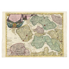
Antique Map of Zeeland, The Netherlands, by Jaillot, 1693
$851.28
$1,064.1020% Off
£630.20
£787.7520% Off
€712
€89020% Off
CA$1,177.96
CA$1,472.4520% Off
A$1,298.67
A$1,623.3420% Off
CHF 679.42
CHF 849.2820% Off
MX$15,932.27
MX$19,915.3420% Off
NOK 8,552.58
NOK 10,690.7320% Off
SEK 7,998.02
SEK 9,997.5220% Off
DKK 5,423.58
DKK 6,779.4720% Off
About the Item
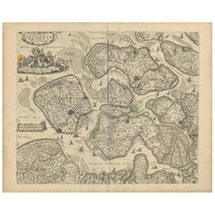
Antique map titled 'Le Comte de Zeelande (..).' Detailed map of the province of Zeeland, The Netherlands. Details shown include fortified towns, roads, sandbanks and marshlands. Based upon the earlier work of Sanson. Source unknown, to be determined.
Artists and Engravers: Alexis-Hubert Jaillot (1632-1712), was a French cartographer. He joined the Sanson heirs and redrew Nicolas Sanson's maps on a larger scale.
Condition: Good, given age. Some staining and soiling, mainly in the margins. A few minor crinkles and creases. Minor paper separation top and bottom middle fold, not affecting image. Vertical crease left of middle fold. Original middle fold as issued. General age-related toning and/or occasional minor defects from handling. Please study image carefully.
Date: 1693
Overall size: 65 x 51.3 cm.
Image size: 56.2 x 42.8 cm.
We sell original antique maps to collectors, historians, educators and interior decorators all over the world. Our collection includes a wide range of authentic antique maps from the 16th to the 20th centuries. Buying and collecting antique maps is a tradition that goes back hundreds of years. Antique maps have proved a richly rewarding investment over the past decade, thanks to a growing appreciation of their unique historical appeal. Today the decorative qualities of antique maps are widely recognized by interior designers who appreciate their beauty and design flexibility. Depending on the individual map, presentation, and context, a rare or antique map can be modern, traditional, abstract, figurative, serious or whimsical. We offer a wide range of authentic antique maps for any budget.
- Dimensions:Height: 20.2 in (51.3 cm)Width: 25.6 in (65 cm)Depth: 0 in (0.01 mm)
- Materials and Techniques:
- Period:
- Date of Manufacture:1693
- Condition:Condition: Good, given age. Some staining and soiling, mainly in the margins. A few minor crinkles and creases. Minor paper separation top & bottom middle fold, not affecting image. Vertical crease left of middle fold. Original middle fold as issued.
- Seller Location:Langweer, NL
- Reference Number:Seller: PCT-619531stDibs: LU3054335517512
About the Seller
5.0
Recognized Seller
These prestigious sellers are industry leaders and represent the highest echelon for item quality and design.
Platinum Seller
Premium sellers with a 4.7+ rating and 24-hour response times
Established in 2009
1stDibs seller since 2017
2,613 sales on 1stDibs
Typical response time: <1 hour
- ShippingRetrieving quote...Shipping from: Langweer, Netherlands
- Return Policy
Authenticity Guarantee
In the unlikely event there’s an issue with an item’s authenticity, contact us within 1 year for a full refund. DetailsMoney-Back Guarantee
If your item is not as described, is damaged in transit, or does not arrive, contact us within 7 days for a full refund. Details24-Hour Cancellation
You have a 24-hour grace period in which to reconsider your purchase, with no questions asked.Vetted Professional Sellers
Our world-class sellers must adhere to strict standards for service and quality, maintaining the integrity of our listings.Price-Match Guarantee
If you find that a seller listed the same item for a lower price elsewhere, we’ll match it.Trusted Global Delivery
Our best-in-class carrier network provides specialized shipping options worldwide, including custom delivery.More From This Seller
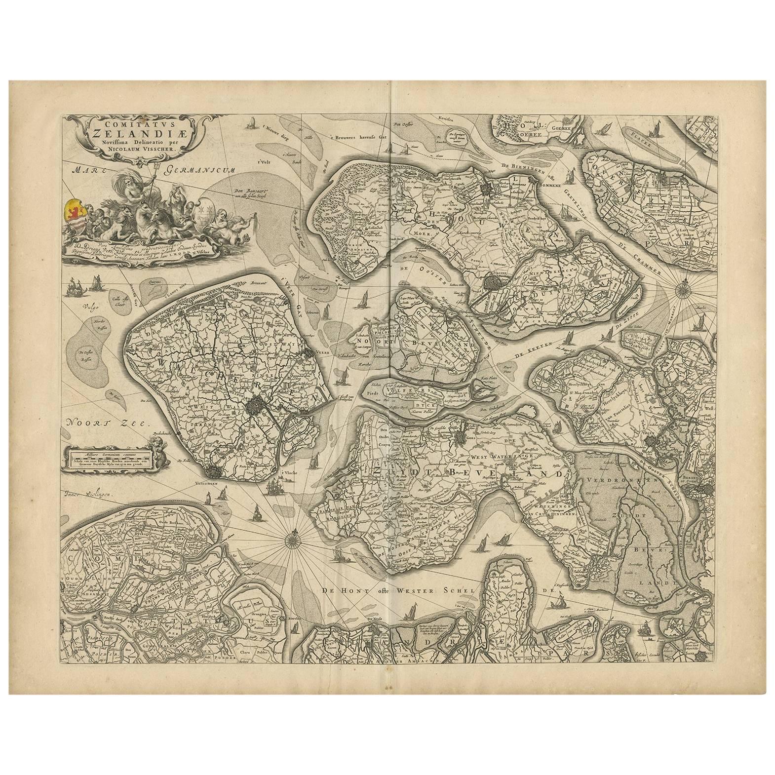
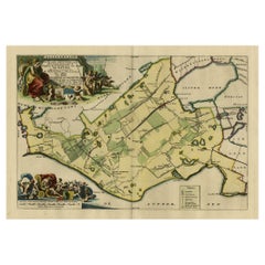
View AllAntique Map of Zeeland 'The Netherlands' by N. Visscher, circa 1690
Located in Langweer, NL
Antique map titled 'Comitatus Zelandiae (..)'. Detailed chart of the province Zeeland, The Netherlands, with details shown pictorially. Published by N. Visscher.
Category
Antique Late 17th Century Maps
Materials
Paper
$631 Sale Price
20% Off
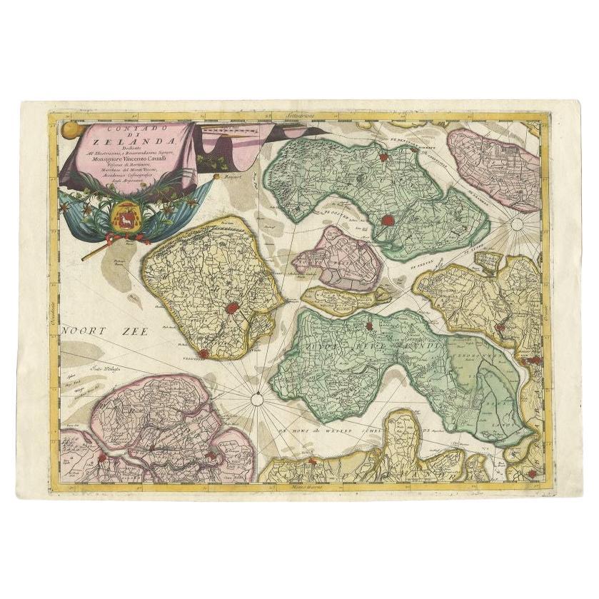
Antique Map of the Province of Zeeland, The Netherlands by Coronelli, 1692
Located in Langweer, NL
Antique map titled 'Contado di Zelanda'. Beautiful map of the Dutch province of Zeeland. With the islands of Walcheren, Schouwen-Duiveland, Noord-Beveland, Zuid-Beveland, Tholen and ...
Category
Antique 17th Century Maps
Materials
Paper
$640 Sale Price
20% Off
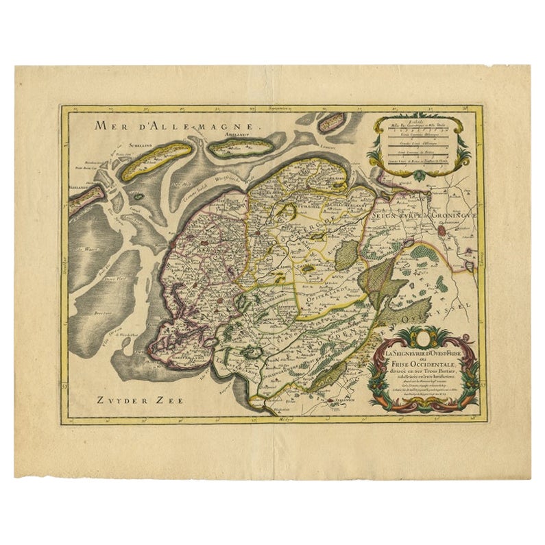
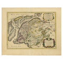
Antique Map of Friesland by De Wit, c.1690
Located in Langweer, NL
Antique map titled 'Tabula Comitatus Frisiae'.
Old map of the province of Friesland, the Netherlands. With a small inset map of the Wadden area. Third state of the map by Schotan...
Category
Antique 17th Century Maps
Materials
Paper

$784 Sale Price
20% Off
Antique Map of Friesland in the Netherlands, 1770
Located in Langweer, NL
Antique map titled 'De Synode van Friesland, in VI Klassen verdeeld door W.A. Bachiene?. Map of the province of Friesland, the Netherlands. This map originates from 'Nieuwe kerkelyke...
Category
Antique 18th Century Maps
Materials
Paper

$143 Sale Price
20% Off
Antique Map of Gaasterland in Friesland, the Netherlands, 1718
Located in Langweer, NL
Antique map titled 'Gaasterland. De zevende Grietenije van de Zevenwolden (..)'. Original antique map of Gaasterland, Friesland, the Netherlands. Originates from 'Uitbeelding van de ...
Category
Antique 18th Century Maps
Materials
Paper
$621 Sale Price
20% Off
French Edition of an Antique Map of Friesland in the Netherlands, 1709
Located in Langweer, NL
Antique Map of Friesland – “La Seigneurie d’Ouest-Frise ou Frise Occidentale” by Jaillot, 1709
This elegant and detailed map, titled “La Seigneurie d’Ouest-Frise ou Frise Occidental...
Category
Antique 18th Century Dutch Maps
Materials
Paper
$621 Sale Price
20% Off
You May Also Like
1752 Vaugoundy Map of Flanders : Belgium, France, and the Netherlands, Ric.a002
Located in Norton, MA
Large Vaugoundy Map of Flanders:
Belgium, France, and the Netherlands
Colored -1752
Ric.a002
Description: This is a 1752 Didier Robert de Vaugondy map of Flanders. The map de...
Category
Antique 17th Century Unknown Maps
Materials
Paper

1643 Willem&Joan Blaeu Map NW Flanders "Flandriae Teutonicae Pars Prientalior
Located in Norton, MA
1643 Willem and Joan Blaeu map of northwest Flanders, entitled
"Flandriae Teutonicae Pars Prientalior,"
Ric0012
" Authentic" - Map of the northwest Fl...
Category
Antique 17th Century Dutch Maps
Materials
Paper

1635 Willem Blaeu Map of Northern France"Comitatvs Bellovacvm" Ric.a08
Located in Norton, MA
1635 Willem Blaeu map of northern France, entitled.
"Comitatvs Bellovacvm Vernacule Beavvais,"
Colored
Ric.a008
“COMITATVS BELLOVACVM…” Amsterdam: W...
Category
Antique 17th Century Unknown Maps
Materials
Paper

North Holland, Netherlands: A Large 17th C. Hand-colored Map by Sanson & Jaillot
By Nicholas Sanson d'Abbeville
Located in Alamo, CA
This large hand-colored map entitled "Le Comte De Hollande Dressee sur les Memoires les plus Nouveaux" was originally created by Nicholas Sanson d'Abbeville. This version was publish...
Category
1690s Landscape Prints
Materials
Engraving

1620 Map of Artois Entitled "Artesia Comitatvs Artois, " by Bleau, Ric.a012
Located in Norton, MA
1640 map of Artois entitled
"Artesia Comitatvs Artois,"
by Bleau
Colored
A-012.
Detailed map of the northern province of Artois, France on the border with Belgium. Feature...
Category
Antique 17th Century Dutch Maps
Materials
Paper

Utrecht, Netherlands: A Large 17th Century Hand-colored Map by Sanson & Jaillot
By Nicholas Sanson d'Abbeville
Located in Alamo, CA
This large hand-colored map entitled "La Seigneurie d'Utrecht. Dressé sur les memoires les plus nouveaux par le Sr. Sanson" was originally created by Nicholas Sanson d'Abbeville. Thi...
Category
1690s Landscape Prints
Materials
Engraving

More Ways To Browse
Cape Cod Map
F Colton
Ithaca Antique Map
J Thayer
Russia Globe
Salt Lake City Used Furniture
World Map Copper
Vintage Danish Tables And Chairs
Navy Blue Turkish Rug
Dutch Mid Century Modern Table
Paris Exposition 1925
Sterling Silver Dinner Sets
England Antique Plates
Rosenthal Century
Vintage Italian Ceramic
Black Scandinavian Modern Dining Chairs
Louis French Tables Fluted
Used Pianos Pianos