Want more images or videos?
Request additional images or videos from the seller
1 of 6
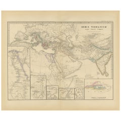
Empires of the East: The Indo-Scythian and Parthian Kingdoms, Published in 1880
Price:$400.99
$445.55List Price
About the Item
- Dimensions:Height: 15.56 in (39.5 cm)Width: 18.51 in (47 cm)Depth: 0 in (0.02 mm)
- Materials and Techniques:
- Period:
- Date of Manufacture:1880
- Condition:Good, given age. General age-related toning, especially around the edges. Vertical folding line as issued. Please study scan carefully.
- Seller Location:Langweer, NL
- Reference Number:Seller: BG-13686-2-161stDibs: LU3054338541292
About the Seller
5.0
Recognized Seller
These prestigious sellers are industry leaders and represent the highest echelon for item quality and design.
Platinum Seller
Premium sellers with a 4.7+ rating and 24-hour response times
Established in 2009
1stDibs seller since 2017
2,641 sales on 1stDibs
Authenticity Guarantee
In the unlikely event there’s an issue with an item’s authenticity, contact us within 1 year for a full refund. DetailsMoney-Back Guarantee
If your item is not as described, is damaged in transit, or does not arrive, contact us within 7 days for a full refund. Details24-Hour Cancellation
You have a 24-hour grace period in which to reconsider your purchase, with no questions asked.Vetted Professional Sellers
Our world-class sellers must adhere to strict standards for service and quality, maintaining the integrity of our listings.Price-Match Guarantee
If you find that a seller listed the same item for a lower price elsewhere, we’ll match it.Trusted Global Delivery
Our best-in-class carrier network provides specialized shipping options worldwide, including custom delivery.You May Also Like
Map of the Kingdom of Sardinia and Part of the Kingdom of Genoa, Rome
By Giovanni Maria Cassini
Located in Hamilton, Ontario
18th century map by Italian engraver Giovanni Maria Cassini (Italy 1745-1824). Map of Part of the Kingdom of Sardinia and Part of the Kingdom of Genoa: Rome. This is a hand colored a...
Category
Antique 18th Century Italian Maps
Materials
Paper

$795 Sale Price
36% Off
H 20.75 in W 25.25 in D 0.1 in
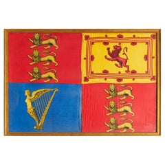
Antique Royal Standard of the United Kingdom in Giltwood Frame and Under Glass
Located in Morristown, NJ
An antique Royal Standard of the United Kingdom, possibly by Benjamin Edgington, London. The fabric is in a giltwood frame under glass. Each of the four quadrants on the flag represe...
Category
Antique 1830s English British Colonial Historical Memorabilia
Materials
Fabric, Glass, Wood
$1,475
H 25.5 in W 37.5 in D 1 in
London 1744 Published Watercolour Antique Map of East Africa by Eman Bowen
Located in West Sussex, Pulborough
We are delighted to offer for sale this New and Accurate Map of Nubia & Abissinia, together with all the Kingdoms Tributary Thereto, and bordering upon them published in 1744 by Emanuel Bowen
This is a decorative antique engraved map of East Africa...
Category
Antique 1740s English George III Maps
Materials
Paper

$1,309
H 17.52 in W 21.07 in D 0.79 in
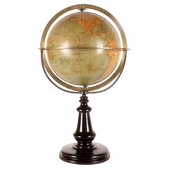
A terrestral globe signed Périgot, published by Delagrave, Paris 1880.
Located in Milan, IT
A Medium-sized terrestrial globe, made of papier-mâché, finished with pastille and completed by the application of paper spindles imprinted with intaglio printing. Color touch-ups. T...
Category
Antique Late 19th Century French Scientific Instruments
Materials
Brass
$4,214
H 19.75 in W 12 in D 12 in
The Kingdoms of Edward Hicks by Carolyn J. Weekley, and Laura Pass Barry
Located in valatie, NY
The Kingdoms of Edward Hicks (Abby Aldrich Rockefeller Folk Art Center Series.) by Carolyn J. Weekley, and Laura Pass Barry. 254 pp. with 173 illustrations, including 131 plates in f...
Category
1990s American Books
Materials
Paper

$125
H 11.25 in W 9 in D 1 in
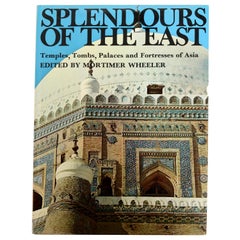
Splendours of the East Temples Tombs Palaces and Fortresses of Asia
Located in valatie, NY
Splendours of the East Temples Tombs Palaces and Fortresses of Asia by Mortimer Wheeler. Spring Pub., London, New York, 1970. Hardcover with dust jacket. 288 pages; illustrated with ...
Category
Vintage 1970s American Books
Materials
Paper
The Kingdom of God in America by H. Richard Niebuhr, Rare Signed 1st Ed
Located in valatie, NY
The Kingdom of God in America by H. Richard Niebuhr. Rare Signed 1st EdIt hardcover with dust jacket. Published by Willet, Clark & Co. Chicago and New York. This book remains the cla...
Category
Vintage 1930s American Books
Materials
Paper
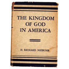
$130
H 8 in W 5.75 in D 1.25 in
7 Volumes. M.A. Thiers. History Of The Consulate and The Empire Of France
Located in New York, NY
7 Volumes. M.A. Thiers. History Of The Consulate and The Empire Of France Under Napoleon. Bound in full tan calf, marbled edges and endpapers, raised bands, ornate gilt on spines, il...
Category
Antique 19th Century English Books
Materials
Leather
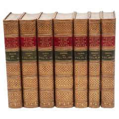
$1,800 / set
H 3 in W 5.5 in D 1.5 in
Large Original Vintage Map of the United Kingdom, circa 1920
Located in St Annes, Lancashire
Great map of The United Kingdom
Unframed
Original color
By John Bartholomew and Co. Edinburgh Geographical Institute
Published, circa 1920
Free shipping.
Category
Vintage 1920s British Maps
Materials
Paper

$50
Free Shipping
H 23 in W 18 in D 0.07 in
1840 Map of the City of Washington Published by William M. Morrison
Located in Colorado Springs, CO
This map, printed in 1840, is a detailed representation of Washington, D.C. in the mid-19th century. The map shows block numbers, wards, and government buildings as well as details o...
Category
Antique 1840s American Federal Maps
Materials
Paper

$3,650
H 24.75 in W 29.5 in D 1.5 in
More From This Seller
View AllThe World in the Assyrian Empire's Era: A Historical Map, Published in 1880
Located in Langweer, NL
This map from the "Spruner-Menke Atlas Antiquus" is titled "ORBIS TERRARVM regni Assyrii tempore," which translates to "The World at the Time of the Assyrian Kingdom." It depicts the...
Category
Antique 1880s Maps
Materials
Paper
$356 Sale Price
20% Off
Free Shipping
Original Antique Map of the United Kingdom and Ireland, Published in 1875
Located in Langweer, NL
Antique map titled 'Iles Britanniques ou Royaume-Uni de la Grande Bretagne (..)'. Large map of the United Kingdom and Ireland. This map originates from...
Category
Antique Late 19th Century French Maps
Materials
Paper

$295 Sale Price
30% Off
Empire of the Parthians: Historical Cartographic Masterpiece by d'Anville, 1819
Located in Langweer, NL
Description:
Ancient map of the Parthian Empire (19th century), original engraving extracted from the atlas of the history of the emperors from 1819, based on the history of the Rom...
Category
Antique 1810s Maps
Materials
Paper
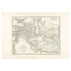
$95 Sale Price
20% Off
Ancient Cartography of the Indian Subcontinent, Published in 1880
Located in Langweer, NL
This map is titled "INDIA," and it provides a detailed view of the Indian subcontinent with various inset maps that offer additional historical and geographical context.
The main ma...
Category
Antique 1880s Maps
Materials
Paper

$356 Sale Price
20% Off
Free Shipping
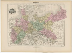
Antique Map of the Kingdom of Prussia, 1880
Located in Langweer, NL
Antique map titled 'Prusse'. Old map of the Kingdom of Prussia, with a decorative vignette of the gate of Brandenburg, Berlin. This map originates from 'Géographie Universelle Atlas-...
Category
Antique 19th Century Maps
Materials
Paper
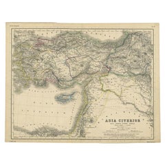
Original Antique Map of the Middle East, Published in Germany, c.1870
Located in Langweer, NL
Antique map titled 'Asia Citerior'. Old map of the Middle East. This map originates from 'Atlas Antiquus, twaalf kaarten behoorende bij de Oude ...
Category
Antique 19th Century Maps
Materials
Paper