Items Similar to Framed 17th Century Map of Cumberland, England by John Speed, 1610


Want more images or videos?
Request additional images or videos from the seller
1 of 15
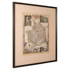
Framed 17th Century Map of Cumberland, England by John Speed, 1610
$1,350
£1,023.49
€1,179.81
CA$1,901.26
A$2,108.35
CHF 1,107.78
MX$25,760.51
NOK 13,859.89
SEK 13,009.88
DKK 8,807.50
About the Item
A fascinating and richly detailed antique map of Cumberland County in northwest England, drawn and published by the celebrated English cartographer John Speed, dated 1610. This early 17th-century engraving captures the historic landscape with remarkable clarity, depicting the ancient city of Carlisle, its surrounding topography, heraldic coats of arms, and decorative elements emblematic of Speed's style.
Hand-colored and printed on laid paper, this map includes vignettes, a city plan of Carlisle, Roman antiquities, and historical notes, reflecting the era's fascination with classical history and topographical scholarship. The decorative title cartouche and maritime illustrations further enhance its aesthetic appeal.
Professionally matted and presented in a contemporary giltwood frame with conservation glass, this piece is both an exceptional historical document and a decorative focal point.
A rare and evocative example of early English cartography. Ideal for collectors of antiquarian prints, historians, and lovers of classical design!
- Creator:John Speed (Maker)
- Dimensions:Height: 23 in (58.42 cm)Width: 27 in (68.58 cm)Depth: 1 in (2.54 cm)
- Style:British Colonial (Of the Period)
- Materials and Techniques:
- Place of Origin:
- Period:Early 17th Century
- Date of Manufacture:1610
- Condition:Wear consistent with age and use. Minor age-toning and scattered foxing; beautifully preserved.
- Seller Location:Middleburg, VA
- Reference Number:Seller: 62121stDibs: LU872628342372
About the Seller
4.9
Vetted Professional Seller
Every seller passes strict standards for authenticity and reliability
Established in 1986
1stDibs seller since 2009
114 sales on 1stDibs
Typical response time: 4 hours
- ShippingRetrieving quote...Shipping from: Middleburg, VA
- Return Policy
Authenticity Guarantee
In the unlikely event there’s an issue with an item’s authenticity, contact us within 1 year for a full refund. DetailsMoney-Back Guarantee
If your item is not as described, is damaged in transit, or does not arrive, contact us within 7 days for a full refund. Details24-Hour Cancellation
You have a 24-hour grace period in which to reconsider your purchase, with no questions asked.Vetted Professional Sellers
Our world-class sellers must adhere to strict standards for service and quality, maintaining the integrity of our listings.Price-Match Guarantee
If you find that a seller listed the same item for a lower price elsewhere, we’ll match it.Trusted Global Delivery
Our best-in-class carrier network provides specialized shipping options worldwide, including custom delivery.More From This Seller
View AllCollection of 18th-Century Engravings of Furniture & Decorative Arts
Located in Middleburg, VA
An extraordinary suite of eight masterful engravings, each a captivating marriage of artistry, craftsmanship, and cultural imagination! Created in the mid-18th century, these prints ...
Category
Antique Mid-18th Century French Neoclassical Drawings
Materials
Wood, Glass, Giltwood, Paper
18th Century French Provincial Watercolor
Located in Middleburg, VA
18th Century French Provincial Watercolor. Depicting a Lady and Gentleman riding horses in the original gilt frame, circa 1790.
Pencil and watercolor on toned paper.
Sight Size: 8"...
Category
Antique 18th Century French French Provincial Paintings
Materials
Glass, Paper

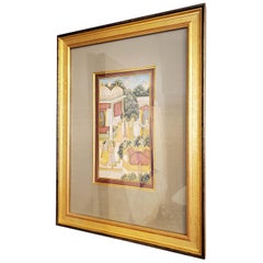
Mid-18th Century Indian Court Painting of Krishna and Radha, Gouache with Gold
Located in Middleburg, VA
A superbly detailed mid-18th-century Indian miniature court painting, executed in gouache heightened with gold on handmade paper. Originating from Rajasthan circa 1760, this exquisite artwork captures a serene palace scene featuring the Hindu deity Krishna with Radha and accompanying Gopis in a lush, architectural setting. The composition is rich in symbolism, narrative depth, and emotional subtlety, hallmarks of classical Rajput painting.
The figures are adorned with traditional garments, rendered in delicate pastel tones with intricate patterns and gilt accents. The architectural elements, marble pavilions, domes, carved screens, and floral gardens, are meticulously executed, offering a vivid impression of royal leisure and divine romance.
Set against a tree-lined courtyard with peacocks and floral motifs, the visual rhythm is both vibrant and harmonious. The painting is professionally mounted in a deep tan linen mat and presented in an elegant gold-gilt frame with black detailing, complementing the composition's refined warmth and historic gravitas.
A rare and captivating example of classical Indian court painting...
Category
Antique Mid-18th Century Indian Paintings
Materials
Gold Leaf
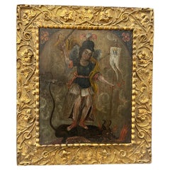
17th Century Spanish Colonial Cusco School Painting
Located in Middleburg, VA
A rare and evocative example of Spanish Colonial art from the Cusco School, this 17th-century oil on wood panel captures the iconic biblical scene of Sain...
Category
Antique 17th Century Peruvian Paintings
Materials
Wood, Paint, Giltwood
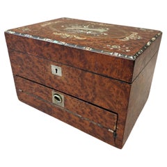
Mid-19th Century British Empire Burled Yew and Amboyna Travel Jewelry Box
Located in Middleburg, VA
A rare and exquisitely crafted British Empire travel jewelry box, made in England circa 1840. The exterior is richly veneered in burled yew wood and amboyna, prized for their deep fi...
Category
Antique Mid-19th Century English Jewelry Boxes
Materials
Silver, Metal, Brass
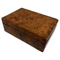
Late 18th Century George III English Box
Located in Middleburg, VA
Late 18th Century George III English Box. Veneered in beautifully highly figured burled ash with small inlaid shield shapes. Made in England circa 1790.
A beautifully crafted late 1...
Category
Antique Late 18th Century English George III Decorative Boxes
Materials
Metal
You May Also Like
Antique County Map of Cheshire, Dutch, Framed, Cartography, Janssonius, C.1660
Located in Hele, Devon, GB
This is an antique county map of Cheshire. A Dutch, framed atlas engraving by Johannes Janssonius, dating to the 17th century and later.
A treat for the collector or county native,...
Category
Antique Mid-17th Century Dutch Charles II Maps
Materials
Glass, Wood, Paper

Antique Map of Essex by Overton, circa 1710
Located in Langweer, NL
Antique map titled 'Essex, devided into Hundreds, with the most antient and fayre Towne Colchester (..)'. Map of Essex, England. Includes an inset town pl...
Category
Antique Early 18th Century Maps
Materials
Paper

$904 Sale Price
20% Off
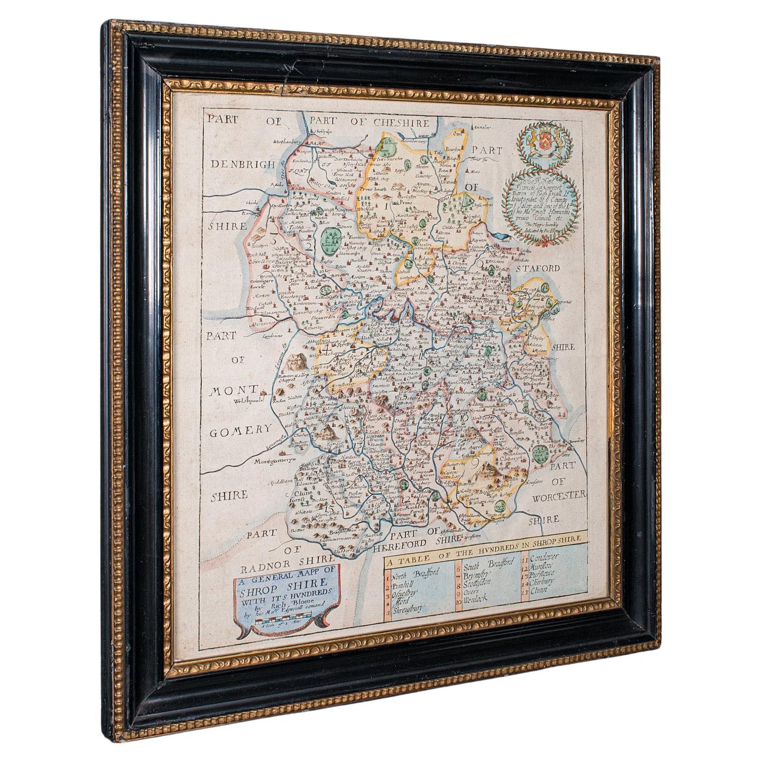
Antique County Map, Shropshire, English, Atlas Engraving, Richard Blome, C.1673
Located in Hele, Devon, GB
This is an antique county map of Shropshire. An English, framed atlas engraving by Richard Blome, dating to the 17th century and later.
A treat for the collector or county native, ...
Category
Antique 17th Century British Restauration Maps
Materials
Glass, Wood, Paper

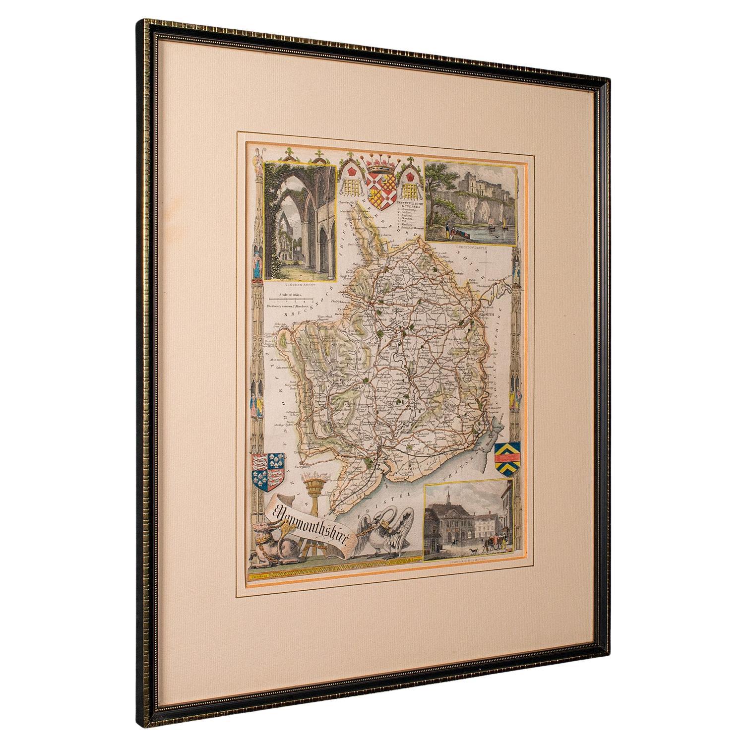
Antique Lithography Map, Monmouthshire, Framed, Welsh Cartography, Victorian
Located in Hele, Devon, GB
This is an antique lithography map of Monmouthshire. An English, framed atlas engraving of cartographic interest, dating to the mid 19th century and later.
Superb lithography of Mo...
Category
Antique Mid-19th Century British Victorian Maps
Materials
Glass, Wood, Paper
Antique Lithography Map, Bedfordshire, English, Framed Engraving, Cartography
Located in Hele, Devon, GB
This is an antique lithography map of Bedfordshire. An English, framed atlas engraving of cartographic interest, dating to the mid 19th century and...
Category
Antique Mid-19th Century British Victorian Maps
Materials
Wood

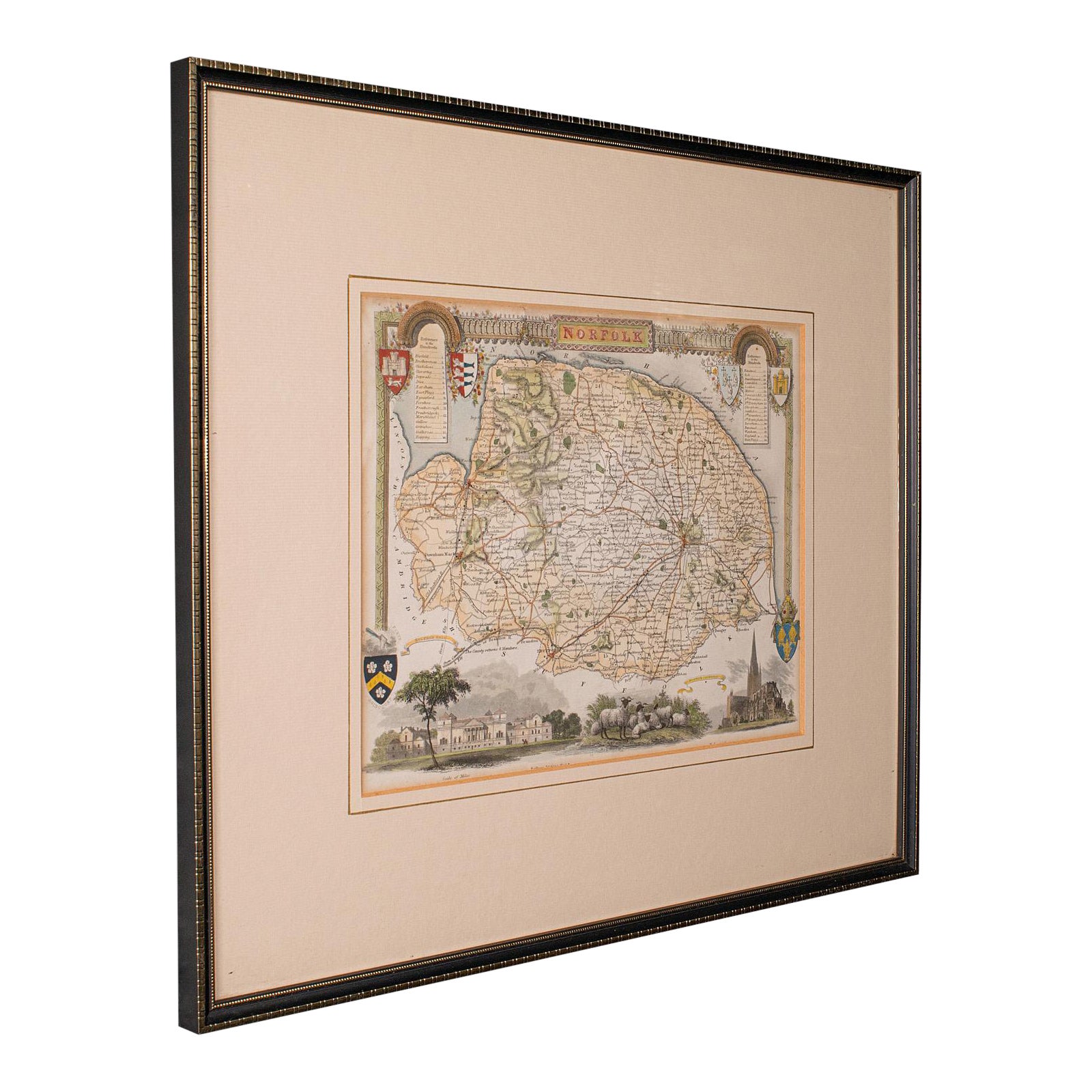
Antique County Map, Norfolk, English, Framed Lithography, Cartography, Victorian
Located in Hele, Devon, GB
This is an antique lithography map of Norfolk. An English, framed atlas engraving of cartographic interest, dating to the mid 19th century and later.
Superb lithography of Norfolk a...
Category
Antique Mid-19th Century British Victorian Maps
Materials
Glass, Wood
More Ways To Browse
17th Century Engravings
Framing Antique Documents
Historical Documents
17th Century Copper
Framed Coat Of Arms
English Early 17th Century Furniture
Gilt Coat Of Arms
Copper Leaf Frame
Caucasus Map
Map Of Puerto Rico
Nevada Antique Map
Shetland Map
Antique Chicago Maps
Kolkata Antique Furniture
Antique Bermuda Furniture
Antique Dairy Collectibles
Antique Map Of Cuba
Antique Map Of Yorkshire