Items Similar to Map of the Mozambique and Tanzania Coast & Inset Map of Anjouan Island, ca.1700


Want more images or videos?
Request additional images or videos from the seller
1 of 5
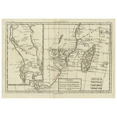
Map of the Mozambique and Tanzania Coast & Inset Map of Anjouan Island, ca.1700
$612.95
$766.1920% Off
£452.15
£565.1820% Off
€512
€64020% Off
CA$849.28
CA$1,061.6020% Off
A$921.60
A$1,151.9920% Off
CHF 488.36
CHF 610.4620% Off
MX$11,302.92
MX$14,128.6520% Off
NOK 6,043.48
NOK 7,554.3420% Off
SEK 5,710.76
SEK 7,138.4620% Off
DKK 3,898.78
DKK 4,873.4820% Off
About the Item
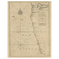
Antique map titled 'Carte particuliere des Costes de l'Afrique'.
Depicts the coasts of Mozambique and Tanzania. With an inset map of Anjouan Island.
Artists and engravers: Published by H. Jaillot and P. Mortier, Amsterdam.
- Dimensions:Height: 20.48 in (52 cm)Width: 24.81 in (63 cm)Depth: 0 in (0.02 mm)
- Materials and Techniques:
- Period:1700-1709
- Date of Manufacture:circa 1700
- Condition:Wear consistent with age and use. Condition: Good, original/contemporary hand coloring. General age-related toning, minor wear. Please study image carefully.
- Seller Location:Langweer, NL
- Reference Number:Seller: BG-00805 1stDibs: LU3054327092862
About the Seller
5.0
Recognized Seller
These prestigious sellers are industry leaders and represent the highest echelon for item quality and design.
Platinum Seller
Premium sellers with a 4.7+ rating and 24-hour response times
Established in 2009
1stDibs seller since 2017
2,622 sales on 1stDibs
Typical response time: <1 hour
- ShippingRetrieving quote...Shipping from: Langweer, Netherlands
- Return Policy
Authenticity Guarantee
In the unlikely event there’s an issue with an item’s authenticity, contact us within 1 year for a full refund. DetailsMoney-Back Guarantee
If your item is not as described, is damaged in transit, or does not arrive, contact us within 7 days for a full refund. Details24-Hour Cancellation
You have a 24-hour grace period in which to reconsider your purchase, with no questions asked.Vetted Professional Sellers
Our world-class sellers must adhere to strict standards for service and quality, maintaining the integrity of our listings.Price-Match Guarantee
If you find that a seller listed the same item for a lower price elsewhere, we’ll match it.Trusted Global Delivery
Our best-in-class carrier network provides specialized shipping options worldwide, including custom delivery.More From This Seller
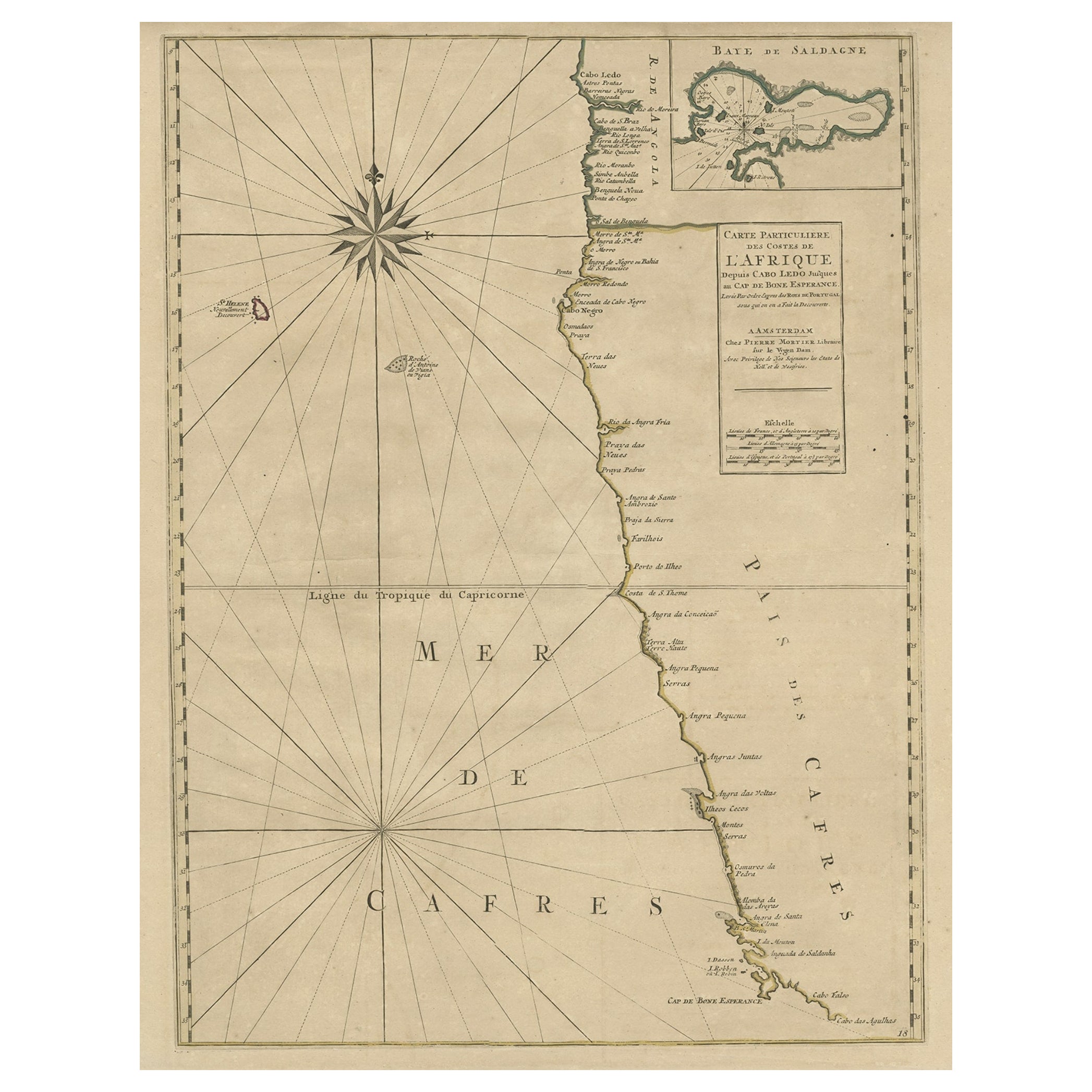
View AllOld Map of the Namibia and South Africa Coasts & Inset of Saldanha Bay, ca.1700
Located in Langweer, NL
Antique map titled 'Carte particuliere des Costes de l'Afrique'.
Map of the coasts of Namibia and South Africa. With an inset map of Saldanha Bay.
Artists and Engravers: Publ...
Category
Antique Early 1700s Maps
Materials
Paper
$612 Sale Price
20% Off
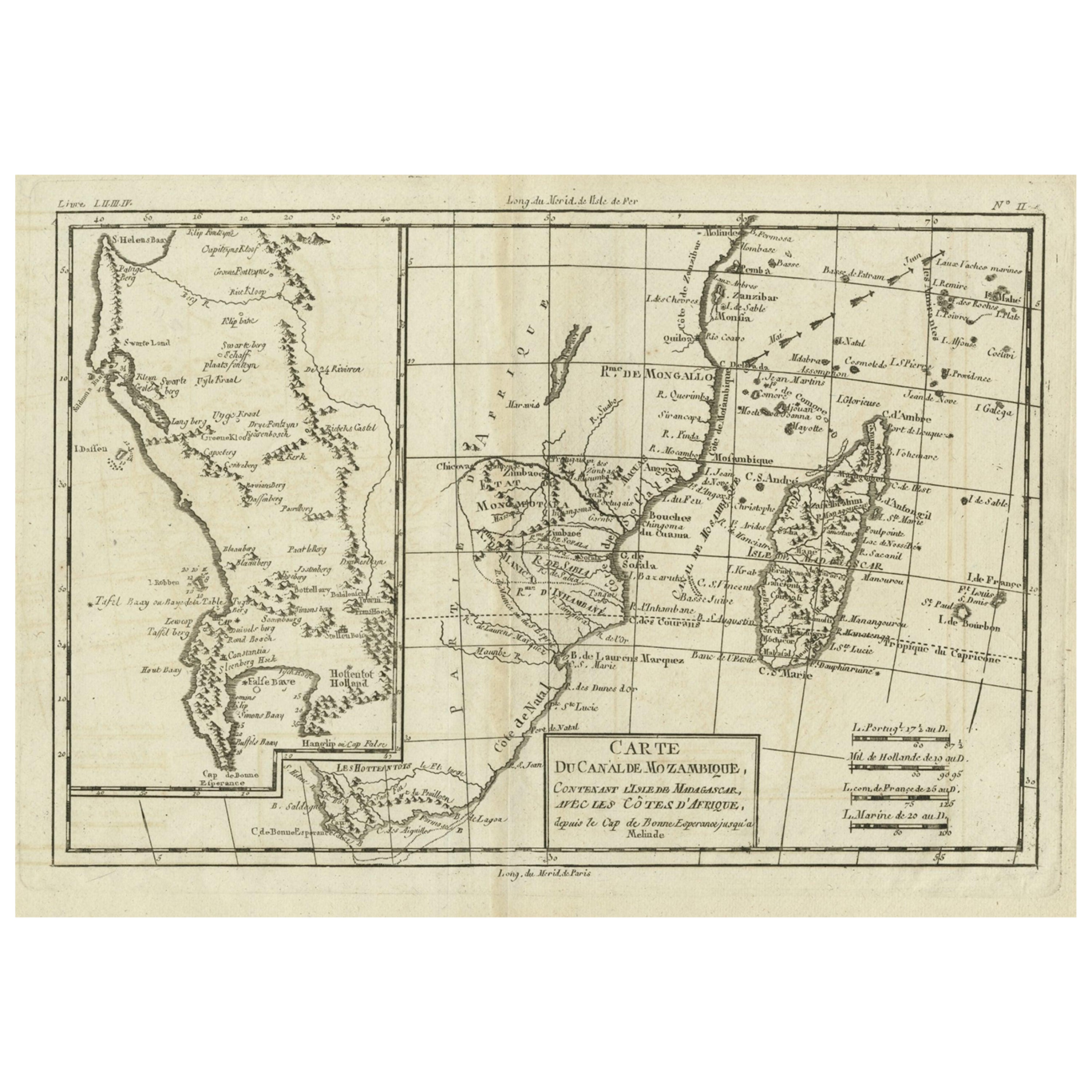
Antique Map of Mozambique Channel with Madagascar and Inset of Cape Region, 1780
Located in Langweer, NL
Antique map titled 'Carte du canal de Mosambique, contenant l'Isle de Madagascar avec les Cotes d'Afrique.' Map of Mozambique Channel, containing the Island of Madagascar with the coasts of Africa from Cape of Good Hope to Melinde. The inset map shows the Cape region in South Africa with False Bay, Robben Island etc. Source unknown, to be determined. Artists and Engravers: Rigobert Bonne (1727-1795 ) was one of the most important cartographers of the late 18th century. In 1773 he succeeded Jacques Bellin as Royal Cartographer to France in the office of the Hydrographer at the Depôt de la Marine. Working in his official capacity Bonne compiled some of the most detailed and accurate maps of the period. Bonne's work represents an important step in the evolution of the cartographic ideology away from the decorative work of the 17th and early 18th century towards a more detail oriented and practical aesthetic. With regard to the rendering of terrain Bonne maps...
Category
Antique 18th Century Maps
Materials
Paper
$421 Sale Price
20% Off
Antique Map of the Cape Verde Islands and Part of Senegal, West Africa, 1690
Located in Langweer, NL
Antique map titled 'Bocche del Fivme Negro et Isole di Capo Verde'. Beautiful double-page map of the Cape Verde Islands and part of the coast of Senegal, with large decorative cartou...
Category
Antique 17th Century Italian Maps
Materials
Paper

Antique Map of Coiba Island, Panama, South America, C.1740
Located in Langweer, NL
Antique map titled 'Plan de la partie orientale de l'Isle de Quibo'. Map of the eastside of Coiba Island (Quibo), Panama, showing the shoreline around Port de Dames indicating soft s...
Category
Antique 18th Century Maps
Materials
Paper

$325 Sale Price
20% Off
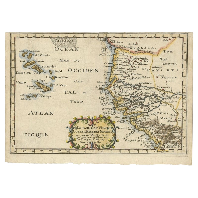
Antique Map of the West African Coast and the Cape Verde Islands, c.1680
Located in Langweer, NL
Antique map Africa titled 'Isles du Cap Verd Coste et Pays des Negres'. Antique map of the coast of Africa and the Cape Verde islands.
Artists and...
Category
Antique 17th Century Maps
Materials
Paper

$344 Sale Price
20% Off
Original Antique Map of the Cape Verde Islands, 1746
Located in Langweer, NL
Antique map titled 'Carte Des Isles Du Cap Verd.' Original antique map of the Cape Verde Islands. Decorative cartouche and compass rose. Extends from Isle d...
Category
Antique 18th Century Maps
Materials
Paper

$162 Sale Price
20% Off
You May Also Like
West Coast of Africa; Guinea & Sierra Leone: Bellin 18th Century Map
Located in Alamo, CA
This is a Jacques Bellin copper-plate map entitled "Partie de la Coste de Guinee Dupuis la Riviere de Sierra Leona Jusquau Cap das Palmas", depicting the coast of Guinea and Sierra L...
Category
1740s Old Masters Landscape Prints
Materials
Engraving

Original Antique Map of South America. C.1780
Located in St Annes, Lancashire
Great map of South America
Copper-plate engraving
Published C.1780
Two small worm holes to left side of map
Unframed.
Category
Antique Early 1800s English Georgian Maps
Materials
Paper

Antique Map - Mare Pacificum - Etching by Johannes Janssonius - 1650s
By Johannes Janssonius
Located in Roma, IT
Mare Pacificum is an antique map realized in 1650 by Johannes Janssonius (1588-1664).
The Map is Hand-colored etching, with coeval watercolorang.
Good conditions with slight foxing...
Category
1650s Modern Figurative Prints
Materials
Etching

West Africa: A 17th Century Hand-Colored Map by Mercator/Hondius
By Gerard Mercator
Located in Alamo, CA
A 17th century hand-colored map entitled "Guineae Nova Descriptio" by Gerard Mercator and Jodocus Hondius, published in their 'Atlas Minor' in Amsterdam in 1635. It is focused on the...
Category
1630s Landscape Prints
Materials
Engraving

Large Original Antique Map of Madagascar. 1894
Located in St Annes, Lancashire
Superb Antique map of Madagascar
Published Edward Stanford, Charing Cross, London 1894
Original colour
Good condition
Unframed.
Free shipping
Category
Antique 1890s English Maps
Materials
Paper

Antique French Map of Asia Including China Indoneseia India, 1783
Located in Amsterdam, Noord Holland
Very nice map of Asia. 1783 Dedie au Roy.
Additional information:
Country of Manufacturing: Europe
Period: 18th century Qing (1661 - 1912)
Condition: Overall Condition B (Good Used)...
Category
Antique 18th Century European Maps
Materials
Paper

$648 Sale Price
20% Off
More Ways To Browse
1700 Antique Furniture
L Afrique Antique
Tanzania Antique Map
Antique Florida Map
Antique Map Chile
Antique Map Of Georgia
Antique Mississippi Furniture
Burgundy Map
John Speed Antique Maps
Malabar Map
Malaysia Map
Map Of Syria
Taiwan Map
Antique Chicago Maps
Dutch Bible
New Jersey 19th Century
Thailand Map
Antique Coal Mining