Items Similar to Regional Antique Map of the Baltic, Extending from Stralsund to Dantzig, ca.1720


Want more images or videos?
Request additional images or videos from the seller
1 of 5
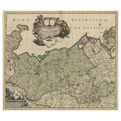
Regional Antique Map of the Baltic, Extending from Stralsund to Dantzig, ca.1720
$844.51
$1,055.6420% Off
£629.62
£787.0320% Off
€712
€89020% Off
CA$1,159.81
CA$1,449.7720% Off
A$1,298.06
A$1,622.5820% Off
CHF 677.79
CHF 847.2420% Off
MX$15,836.42
MX$19,795.5220% Off
NOK 8,603.66
NOK 10,754.5720% Off
SEK 8,164.34
SEK 10,205.4320% Off
DKK 5,423.22
DKK 6,779.0220% Off
Shipping
Retrieving quote...The 1stDibs Promise:
Authenticity Guarantee,
Money-Back Guarantee,
24-Hour Cancellation
About the Item
Antique map titled 'Ducatus Pomeraniae (..)'. Regional map of the Baltic, extending from Stralsund and Rugia in the west to Dantzig and Culman on the Vistula in the east. Large cartouche, one of the most ornate allegorical cartouches to appear on a Homann map.
Artists and Engravers: Johann Baptist Homann (20 March 1664 – 1 July 1724) was a German geographer and cartographer.
- Dimensions:Height: 20.08 in (51 cm)Width: 23.04 in (58.5 cm)Depth: 0 in (0.02 mm)
- Materials and Techniques:
- Period:1720-1729
- Date of Manufacture:circa 1720
- Condition:Condition: Good, general age-related toning. MInor wear and soiling. Blank verso, please study image carefully.
- Seller Location:Langweer, NL
- Reference Number:Seller: BG-12424-1 1stDibs: LU3054327315402
About the Seller
5.0
Recognized Seller
These prestigious sellers are industry leaders and represent the highest echelon for item quality and design.
Platinum Seller
Premium sellers with a 4.7+ rating and 24-hour response times
Established in 2009
1stDibs seller since 2017
2,492 sales on 1stDibs
Typical response time: <1 hour
- ShippingRetrieving quote...Shipping from: Langweer, Netherlands
- Return Policy
Authenticity Guarantee
In the unlikely event there’s an issue with an item’s authenticity, contact us within 1 year for a full refund. DetailsMoney-Back Guarantee
If your item is not as described, is damaged in transit, or does not arrive, contact us within 7 days for a full refund. Details24-Hour Cancellation
You have a 24-hour grace period in which to reconsider your purchase, with no questions asked.Vetted Professional Sellers
Our world-class sellers must adhere to strict standards for service and quality, maintaining the integrity of our listings.Price-Match Guarantee
If you find that a seller listed the same item for a lower price elsewhere, we’ll match it.Trusted Global Delivery
Our best-in-class carrier network provides specialized shipping options worldwide, including custom delivery.More From This Seller
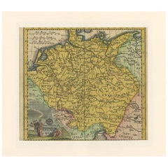
View AllAntique Map of Pomerania by Schenk, circa 1750
Located in Langweer, NL
The "Ducatus Pomeraniae" is a historical map depicting the Duchy of Pomerania, a region that straddles the modern border between northeastern Germany and Poland. Crafted with ornamen...
Category
Antique Mid-18th Century Maps
Materials
Paper

$474 Sale Price
20% Off
Antique Map of the Baltic Region by Homann Heirs, c.1730
Located in Langweer, NL
Antique map titled 'Regnum Borussiae gloriosis auspicijs Seerenissimi et Potentissimi Princip Friderici III (..).' Detailed map of the Baltic region from Memel to Pomerania, extendin...
Category
Antique 18th Century Maps
Materials
Paper
$445 Sale Price
20% Off
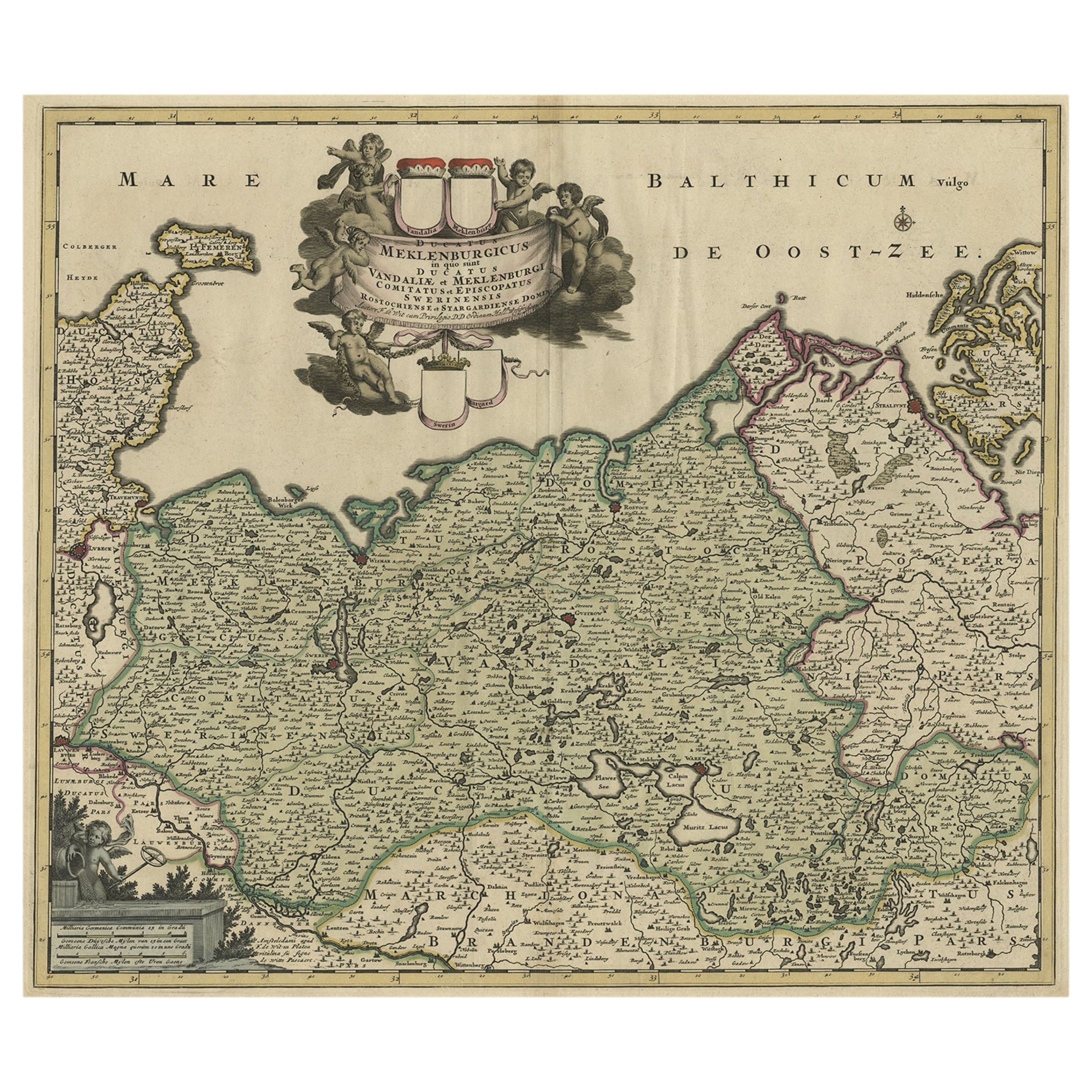
A Handsome & Detailed Map of the Duchy of Mecklenburg & Pomerania, Germany, 1680
Located in Langweer, NL
Antique map titled 'Ducatus Meklenburgicus in quo sunt Ducatus Vandaliae et Meklenburgi Ducatus et Comitatus Swerinensis.'
A handsome and detailed map of the Duchy of Mecklenburg...
Category
Antique 1680s Maps
Materials
Paper
$702 Sale Price
20% Off
Antique Map of European Russia by Tirion, c.1725
Located in Langweer, NL
Antique map titled 'Nieuwe Kaart van Muskovie of Rusland na de laatste ondekking int licht gebracht te Amsterdam by Isaak Tirion'. Detailed map of European Russia.
Artists and En...
Category
Antique 18th Century Maps
Materials
Paper

$901 Sale Price
20% Off
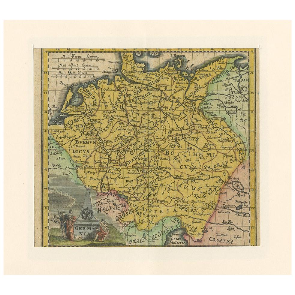
Antique Map of Germany by Hederichs 'circa 1740'
Located in Langweer, NL
Antique map titled 'Germania'. Rare miniature map of Germany and surroundings. This map covers the entirety of those lands traditionally occupied by Germanic peoples, from the Blatic...
Category
Antique Mid-18th Century Maps
Materials
Paper
$237 Sale Price
20% Off
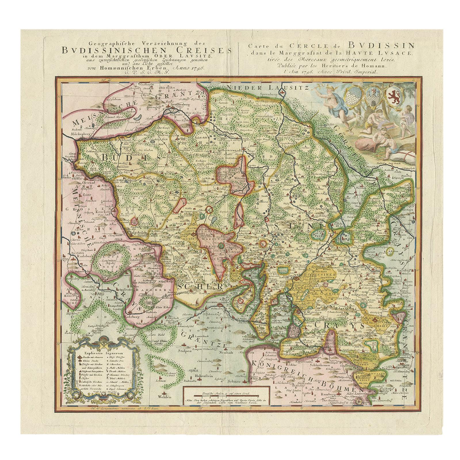
Antique Map of Oberlausitz by Homann Erben, '1746'
Located in Langweer, NL
Antique map titled 'Geographische Verzeichnung des Budissinischen Creises (..) - Carte du Cercle de Budissin (..)'. Copper engraved map of Oberlausitz, a historical region of Saxony ...
Category
Antique Mid-18th Century Maps
Materials
Paper
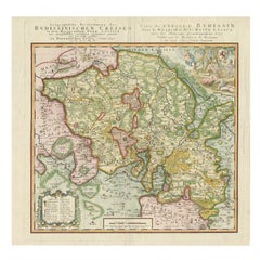
$427 Sale Price
20% Off
You May Also Like
Prussia, Poland, N. Germany, Etc: A Hand-colored 17th Century Map by Janssonius
By Johannes Janssonius
Located in Alamo, CA
This is an attractive hand-colored copperplate engraved 17th century map of Prussia entitled "Prussia Accurate Descripta a Gasparo Henneberg Erlichensi", published in Amsterdam by Joannes Janssonius in 1664. This very detailed map from the golden age of Dutch cartography includes present-day Poland, Latvia, Lithuania, Estonia and portions of Germany. This highly detailed map is embellished by three ornate pink, red, mint green and gold...
Category
Antique Mid-17th Century Dutch Maps
Materials
Paper

18th Century Hand-Colored Homann Map of Germany, Including Frankfurt and Berlin
By Johann Baptist Homann
Located in Alamo, CA
An 18th century hand-colored map entitled "Tabula Marchionatus Brandenburgici et Ducatus Pomeraniae quae sunt Pars Septentrionalis Circuli Saxoniae Superioris" by Johann Baptist Homa...
Category
Antique Early 18th Century German Maps
Materials
Paper

17th Century Hand-Colored Map of a Region in West Germany by Janssonius
By Johannes Janssonius
Located in Alamo, CA
This attractive highly detailed 17th century original hand-colored map is entitled "Archiepiscopatus Maghdeburgensis et Anhaltinus Ducatus cum terris adjacentibus". It was published ...
Category
Antique Mid-17th Century Dutch Maps
Materials
Paper

1643 Willem&Joan Blaeu Map NW Flanders "Flandriae Teutonicae Pars Prientalior
Located in Norton, MA
1643 Willem and Joan Blaeu map of northwest Flanders, entitled
"Flandriae Teutonicae Pars Prientalior,"
Ric0012
" Authentic" - Map of the northwest Fl...
Category
Antique 17th Century Dutch Maps
Materials
Paper

1633 Map Entitled "Beauvaisis Comitatus Belova Cium, Ric.0002
Located in Norton, MA
1633 map entitled
"Beauvaisis Comitatus Belova Cium,"
Hand Colored
Ric.0002
Description: Cartographer : - Hondius, Henricus 1587-1638
Artists and Engravers:Jodocus Hondius, one of the most notable engravers of his time. He is known for his work in association with many of the cartographers and publishers prominent at the end of the sixteenth and the beginning of the seventeenth century. A native of Flanders, he grew up in Ghent, apprenticed as an instrument and globe maker and map engraver. In 1584, to escape the religious troubles sweeping the Low Countries at that time, he fled to London where he spent some years before finally settling in Amsterdam about 1593. In the London period he came into contact with the leading scientists and geographers of the day and engraved maps in The Mariner\\\\\\\\\\\\\\\'s Mirrour, the English edition of Waghenaer\\\\\\\\\\\\\\\'s Sea Atlas, as well as others with Pieter van den Keere, his brother-in-law. No doubt his temporary exile in London stood him in good stead, earning him an international reputation, for it could have been no accident that Speed chose Hondius to engrave the plates for the maps in The Theatre of the Empire of Great Britaine in the years between 1605 and 1610. In 1604 Hondius bought the plates of Mercator\\\\\\\\\\\\\\\'s Atlas which, in spite of its excellence, had not competed successfully with the continuing demand for the Ortelius Theatrum Orbis Terrarum. To meet this competition Hondius added about 40 maps to Mercator\\\\\\\\\\\\\\\'s original number and from 1606 published enlarged editions in many languages, still under Mercator\\\\\\\\\\\\\\\'s name but with his own name as publisher. These atlases have become known as the Mercator/Hondius series. The following year the maps were reengraved in miniature form and issued as a pocket Atlas Minor. After the death of Jodocus Hondius the Elder in 1612, work on the two atlases, folio and miniature, was carried on by his widow and sons, Jodocus II and Henricus, and eventually in conjunction with Jan Jansson in Amsterdam.
In all, from 1606 onwards, nearly 50 editions with increasing numbers of maps with texts in the main European languages were printed. Summaries of these issues are given under the entry for Gerard Mercator. Jodocus Hondius the Elder * 1588 Maps in The Mariner\\\\\\\\\\\\\\\'s Mirrour (Waghenaer/Ashley) * 1590 World Map...
Category
Antique 17th Century Dutch Maps
Materials
Paper

1752 Vaugoundy Map of Flanders : Belgium, France, and the Netherlands, Ric.a002
Located in Norton, MA
Large Vaugoundy Map of Flanders:
Belgium, France, and the Netherlands
Colored -1752
Ric.a002
Description: This is a 1752 Didier Robert de Vaugondy map of Flanders. The map de...
Category
Antique 17th Century Unknown Maps
Materials
Paper

More Ways To Browse
Ptolemy Map
Map Of Jerusalem
1820 World Map
Cyprus Antique Maps
Antique Ecuador
Antique Map Of Thailand
Antique Mississippi Map
Antique Ohio Maps
Burgundy Map
John Speed Maps
Antique Map Of Turkish Empire
Antique Portuguese Scales
Canadian Atlas Furniture
Prussia Map
Afghanistan Map
Malabar Map
Antique Compass Made In France
Antique Maps Dublin