1750s Prints
to
75
88
8
96
Height
to
Width
to
5,107
9,319
5,476
893
1,186
1,692
1,665
186
82
212
239
256
309
412
690
374
227
96
4
2
1
8
5
3
1
1
96
96
96
3
1
Period: 1750s
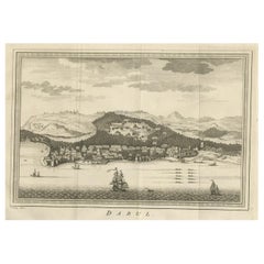
Old Copper Engraving of the Port City Dabhol in India, 1757
Located in Langweer, NL
Antique print titled 'Dabul'.
Old print of the port city Dabhol in India. In the 15th and 16th centuries, Dabul was an opulent Muslim trade center. Around 1660 it was annexed to th...
Category
Antique 1750s Prints
Materials
Paper
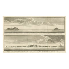
Antique View of The N.W. side of Saypan and one of The Ladrones Islands, 1757
Located in Langweer, NL
Antique print titled 'Vue de deux des Iles des Larrons - Gezigt van twee der Eilanden Ladrones (..)'.
View of two Ladrones Islands; View of the N.W. side of Saypan, one of the La...
Category
Antique 1750s Prints
Materials
Paper
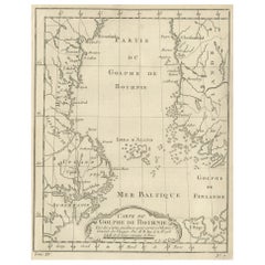
Old Map of the Gulf of Bothnia, the Northernmost Arm of the Baltic Sea, 1759
Located in Langweer, NL
Antique map titled 'Carte du Golphe de Bothnie'.
Original antique map of the Gulf of Bothnia, the northernmost arm of the Baltic Sea. It is situated between Finland's west coast ...
Category
Antique 1750s Prints
Materials
Paper
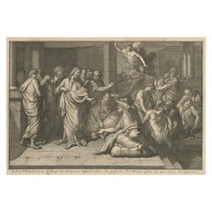
The Angel & Jesus with the Sick in Bethesda Near Jerusalem's Sheep Gate, 1754
Located in Langweer, NL
Antique religious print titled 'L'Ange du Seigneur descend dans la piscine des brebis pour la guerison des malades'.
The Angel descending into the pool of Bethesda...
Category
Antique 1750s Prints
Materials
Paper
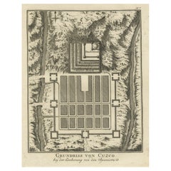
Old Print of the Spanish Conquest of Cusco or Cuzco, Capital of the Incas, c1750
Located in Langweer, NL
Antique print titled 'Grundriss von Cuzco bey der Eroberung von den Spaniern'.
Old plan of the city of Cusco, Peru, often spelled Cuzco. It shows Cusco during the conquest by the...
Category
Antique 1750s Prints
Materials
Paper
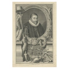
Prince of Orange, First King of the Netherlands & Grand Duke of Luxembourg, 1750
Located in Langweer, NL
Antique portrait titled 'Willem de I. Prins van Oranje enz. enz. enz'.
Portrait of William I, Prince of Orange. William I Frederick, born Willem Frederik Prins van Oranje-Nassau ...
Category
Antique 1750s Prints
Materials
Paper
Large Antique Map of the Region of Berry, Nivernois & Bourbonnais, France, 1753
Located in Langweer, NL
Antique map titled 'Gouvernements généraux du Berry, du Nivernois et du Bourbonois'.
Large, original antique map of the region of Berry, Nivernois and Bourbonnais, France. Featur...
Category
Antique 1750s Prints
Materials
Paper
Nice Antique Map of the Empire of Japan. Centered on the Bay of Osaka, ca.1752
Located in Langweer, NL
Antique map titled 'Carte de L'Empire de Japon (..).'
Map of the Empire of Japan. Centered on the Bay of Osaka, this map covers from Hirado (here identified as I. Firando) and Naga...
Category
Antique 1750s Prints
Materials
Paper
Rare Religious Print of God the Father with S. Actenasius & S.Ianuarius, ca.1750
Located in Langweer, NL
Antique religion print titled 'Pictura vetustissima Altaris S. Salvatoris veteris in Cathedrali Neap'.
Little is known about this interesting antique print. In the middle, an iconography of God the Father...
Category
Antique 1750s Prints
Materials
Paper
Nicely Hand-Colored Antique Map of Part of India, the Ganges & Hindustan, 1755
Located in Langweer, NL
Antique map titled 'Carte de l'Inde en deca du Gange comprenant l' Indoustan (..)'
A map of part of India, the Ganges and Hindustan. From: Antoine Francois Prevost d'Exiles' (or ...
Category
Antique 1750s Prints
Materials
Paper
Bishop William Waynflete, Founder of Magdalen College School in Oxford, ca.1750
Located in Langweer, NL
Antique portrait titled 'William Waynfleet, Bishop of Winchester'.
Portrait of William Waynflete. William Waynflete, born William Patten, was Provost of Eton (1442–1447), Bishop of Winchester (1447–1486) and Lord Chancellor...
Category
Antique 1750s Prints
Materials
Paper
Original Antique Map of the Northwestern Part of Russia in Europe, 1753
Located in Langweer, NL
Antique map titled 'Partie septentrionale de la Russie Européenne'.
Detailed map of the Northwestern part of Russia, from the Gulf of Finland and Poland, to the western part of Asian Russia.
Artists and Engravers: Gilles Robert de Vaugondy (1688-1766) was the head of a leading family of geographers in eighteenth century France. Gilles got his start when he jointly inherited the shop of Pierre-Moullart Sanson, grandson of the famous geographer Nicholas Sanson. The inheritance included the business, its stock of plates, and a roller press...
Category
Antique 1750s Prints
Materials
Paper
Old Map of Turkmenistan, Uzbekistan, Afghanistan, Tajikistan, Kyrgyzstan, 1757
Located in Langweer, NL
Antique map titled 'Kort over det Lille Bukarie og de naest graensende Lande. af Engelske Skribentere ved N. Bellin Ingenieur ved Marinen efter Söe Etaten'.
Map of present-day Turkmenistan, Uzbekistan, Afghanistan, Tajikistan, Kyrgyzstan including part of China. Originates from 'Almindelig histoirie over reiser til lands og bands (..)'. This 17 volume set is a translation of Collection of voyages and travels edited by Awnsham and John Churchill and Thomas Osborne...
Category
Antique 1750s Prints
Materials
Paper
Antique Print of a New Water Exhausting Machine, 1758
Located in Langweer, NL
Antique print titled 'A New Machine for exhausting a large quantity of water'. Print of a new water exhausting machine. This print originates from 'The Universal Magazine...
Category
Antique 1750s Prints
Materials
Paper
Beautiful Portrait of Anne, Princess Royal and Princess of Orange, 1750
Located in Langweer, NL
Antique portrait titled 'Anna, Kroonprinsesse van Grootbrittanje, Gemalinne van Willem de IV, Prins van Oranje'.
Beautiful portrait of Anne, Princess Royal and Princess of Orange (1709-1759). Portrayed in an oval with allegorical symbolism beneath a mirror with a snake, a shield with the royal family coat of arms and other elements.
Anne, Princess Royal and Princess of Orange, was the second child and eldest daughter of King George II of Great Britain and his consort Caroline of Ansbach. She was the wife of William IV, Prince of Orange, the first hereditary stadtholder of all seven provinces of the Northern Netherlands. She was Regent of the Netherlands from 1751 until her death in 1759, exercising extensive powers on behalf of her son William V. She was known as an Anglophile, due to her English upbringing and family connections, but was unable to convince the Dutch Republic to enter the Seven Years' War on the side of the British...
Category
Antique 1750s Prints
Materials
Paper
Original Antique Print Depicting the Distillation of Alcohol, 1751
Located in Langweer, NL
Antique print titled ‘Distillatuer Liquoriste Limonadier, Fourneaux & C.’.
This print depicts the distillation of alcohol. This print originates from ‘The Encyclopeie ou Dictionn...
Category
Antique 1750s Prints
Materials
Paper
Original Antique Engraving of a Alligator, Shark and Fish, ca.1750
Located in Langweer, NL
Antique print titled 'Espece de Crocodile, nomme Alligator Celui ci est Jeune qui fut tire vivant a Londres au mois d'Octobre 1739’. (Species of Crocodile, called Alligator. This you...
Category
Antique 1750s Prints
Materials
Paper
John Gibson - Map of New England
Located in Savannah, GA
A miniature map of New England from John Gibson’s The Atlas Minimus published in 1758.
John Gibson worked in London from 1748-1773 as a geographer and engraver, producing numerous ...
Category
British Other Antique 1750s Prints
Materials
Glass, Paper
A page from A Complete Body Of Architecture by Isaac Ware, 1756
By Isaac Ware
Located in Kenilworth, IL
Page 8 from Issac Ware's book "A Complete Body Of Architecture, Adorned With Plans and Elevations, From Original Designs, By Isaac Ware, Esq. Of His Majesty's B...
Category
British Antique 1750s Prints
Materials
Paper
Map of Vusihyen, Hu Chew Fu and Hou-Tcheou-Fou, Historical Chinese Cities, 1754
Located in Langweer, NL
Given these specific names—Vusihyen, Hu Chew Fu, and Hou-Tcheou-Fou—it appears that the map depicts historical Chinese locations. These names are likely transliterations of Chinese names from the period. "Hu Chew Fu" might be an old Western spelling for what is known in modern pinyin as Huzhou, a city near Lake Tai in China. "Hou-Tcheou-Fou" could refer to a historical name for another city or region, also located in China.
More research needed.
More about the maker:
Jacques-Nicolas Bellin's contributions to cartography and hydrography set a precedent in mapmaking during the 18th century. His role as Hydrographer to the French Navy and later as the Official Hydrographer to the French King placed him at the forefront of maritime charting...
Category
Antique 1750s Prints
Materials
Paper
Engraving of Anthony Madox: 1753 Master Contortionist
Located in Langweer, NL
This engraving features Anthony Madox, an English performer known for his dexterity and contortion skills. He was active in the 18th century and was renowned enough to perform before...
Category
Antique 1750s Prints
Materials
Paper
Old Portrait of Henry Frederick, Prince of Wales, c.1750
Located in Langweer, NL
Antique portrait titled 'Henry, Prince of Wales, Son of K. James I'.
Old portrait of Henry Frederick. Henry Frederick, Prince of Wales (1594-1612) was the elder son of James VI and I, King of England and Scotland, and his wife, Anne of Denmark. Prince Henry was widely seen as a bright and promising heir to his father's thrones. However, at the age of 18, he predeceased his father when he died of typhoid fever. His younger brother Charles succeeded him as heir apparent to the English, Irish and Scottish thrones...
Category
Antique 1750s Prints
Materials
Paper
Engraving of Amalia, Princess of Orange, 1757
Located in Langweer, NL
Rare antique portrait ( proof print circa 1750) with title Amelia, Gravinne van Solms, gemalinne van Frederik Hendrik, Prins van Oranje etc.
Engraving of Amalia, Princess of Orange. Half length with curled hair with pearl ropes, pearl earrings and necklace, low gown, and jewelled bodice.
Artists and Engravers: Jakob Houbraken was a very productive Dutch 18th century engraver...
Category
Antique 1750s Prints
Materials
Paper
Antique Map of Hangzhou, Capital of the Province of Zheijang, China, c.1750
Located in Langweer, NL
Antique map titled ‘Plan de la ville de Hang-Tcheou-Fou ou Hang-Chew-Fu Capitale de la Province de Che-Kiang’. This original print shows a map of the city of Hangzhou, capital of the...
Category
Antique 1750s Prints
Materials
Paper
Palace & Gardens of Shah Shuja, Prince of Rajmahal & Munger, India, 1757
Located in Langweer, NL
Antique print titled 'Paleis en Tuynen van Cha-Sousa Prins van Ragi Mohol - Grondtekening der Stad Mongheer‘.
This print depicts the palace and gardens of Shah Shuja, Prince of R...
Category
Antique 1750s Prints
Materials
Paper
Small Detailed Antique Map of France, with Decorative Title Cartouche, 1754
Located in Langweer, NL
Antique map France titled 'An Accurate Map of France drawn from the best authorities'.
Small, detailed map of France. With decorative title cartouche.
...
Category
Antique 1750s Prints
Materials
Paper
Antique Map of the Gulf of Bothnia, the Northernmost Arm of the Baltic, 1759
Located in Langweer, NL
Antique map titled 'Suite du Golphe de Bothnie'.
Original antique map of the Gulf of Bothnia, the northernmost arm of the Baltic Sea. It is situated between Finland's west coast ...
Category
Antique 1750s Prints
Materials
Paper
Map of the Russian Islands of Novaya Zemlya and Pechorskaya Guba, 1758
Located in Langweer, NL
Antique map titled 'Carte du detroit de Waeigats ou de Nassau.'
Map of the Russian islands of Novaya Zemlya (Nova Zembla) and Pechorskaya Guba, here Nouvelle Zemble and Grande Ba...
Category
Antique 1750s Prints
Materials
Paper
Map of North and East coast of Asia with Japan & inset maps of Kamchatka, c1750
Located in Langweer, NL
Antique map titled 'Nouvelle representation des Cotes Nord et Est de L'Asie.'
Map the north and east coast of Asia, showing an oddly shaped Japan and inset maps of Kamchatka. Thi...
Category
Antique 1750s Prints
Materials
Paper
Decorative Original Antique Panoramic View of Atjeh on Sumatra, Indonesia, 1756
Located in Langweer, NL
Antique print titled 'Achem - Atsjien'.
Decorative panoramic view of Atjeh on Sumatra, Indonesia. On this engraving a pagode like building is visible in the background. In the fo...
Category
Antique 1750s Prints
Materials
Paper
Map of the Circle of Franconia, Germany Bamberg, Wurtzburg and Nuremberg, 1757
Located in Langweer, NL
Antique map titled 'Cercle de Franconie (..)'.
Map of the Circle of Franconia, Germany. Centered on Bamberg, Wurtzburg and Nuremberg. This map originates from 'Atlas Universel (..)'.
Artists and Engravers: Gilles Robert de Vaugondy (1688 - 1766), also known as Le Sieur or Monsieur Robert, and his son, Didier Robert de Vaugondy (c.1723 - 1786), were leading mapmakers in France during the 18th century. In 1757, they published The Atlas Universel, one of the most important atlases of the 18th century. To produce the atlas, the Vaugondys integrated older sources with more modern surveyed maps...
Category
Antique 1750s Prints
Materials
Paper
Allegorical Frontispiece of Freedom and Rights of Haarlem, The Netherlands, 1751
Located in Langweer, NL
Antique print, titled: 'Handvesten der Stad Haerlem' -
Allegorical Frontispiece from 'Handvesten, privilegien, octroyen, vry- en gerechtigheden aan de stad Haerlem …'
Source u...
Category
Antique 1750s Prints
Materials
Paper
William Warham, Archbishop of Canterbury and Lord Chancellor of England, c.1750
Located in Langweer, NL
Antique portrait titled 'William Warham, Archbishop of Canterbury and Lord Chancellor of England'.
Portrait of William Warham. William Warham was t...
Category
Antique 1750s Prints
Materials
Paper
Nicely Colored Original Antique Map of Upper Saxony, Middle Germany, 1756
Located in Langweer, NL
Antique map titled 'Partie Meridionale du cercle de Haute Saxe (..)'.
Original antique map of upper Saxony, Germany. It was the name given to the majority of the German lands held by the House of Wettin, in what is now called Central Germany.
Artists and Engravers: Gilles Robert de Vaugondy (1688 - 1766), also known as Le Sieur or Monsieur Robert, and his son, Didier Robert de Vaugondy (c.1723 - 1786), were leading mapmakers in France during the 18th century. In 1757, they published The Atlas Universel, one of the most important atlases of the 18th century. To produce the atlas, the Vaugondys integrated older sources with more modern surveyed maps...
Category
Antique 1750s Prints
Materials
Paper
Antique Plan of Fort Dauphin on Madagascar of the East Coast of Africa, 1756
Located in Langweer, NL
Antique map titled 'Plan du Fort Dauphin (..) -
Grondtekening van 't Fort Dauphin'. Plan of Fort Dauphin on the island of Madagascar of the east coast of Africa. This print origi...
Category
Antique 1750s Prints
Materials
Paper
Antique Fish Print of Sierra Leona, with The Banana, The Monk and More, c.1752
Located in Langweer, NL
Description: Antique print titled 'Fish at Sierra Leona'. Depicts various fish including 'the Banana, the Trezhar, the Monk and the Bekune'. Originates from Salmon's 'Universal Trave...
Category
Antique 1750s Prints
Materials
Paper
18th-Century Miniature Engraving – Madrid, 1758
Located in Madrid, ES
Antique engraving dated 1758, framed in its original wooden frame.
Origin: Madrid, Spain.
Condition: Well-preserved with fine details.
Frame: Authentic 18th-century wooden frame.
D...
Category
Antique 1750s Prints
Materials
Paper
Antique Monkey Engraving
Located in Dallas, TX
An antique engraving of a monkey called CAGVI minor, dated 1752 signed Edward Delin Anno. In a newer eglomise and guided wood frame with fruits, leaves and insects.
Category
English Antique 1750s Prints
Materials
Paper
