Items Similar to Bermuda: An Early 17th Century Hand-colored Map by Henricus Hondius


Want more images or videos?
Request additional images or videos from the seller
1 of 9
Henricus HondiusBermuda: An Early 17th Century Hand-colored Map by Henricus Hondius1633
1633
$2,975
£2,254.13
€2,586.43
CA$4,186.31
A$4,601.90
CHF 2,418.55
MX$55,883.84
NOK 30,170.78
SEK 28,584.69
DKK 19,303.19
About the Item
This attractive and interesting map of Bermuda by Henricus Hondius in 1633 is entitled "Mappa Aestivarum Insularum, Alias Barmudas". It is based on a survey of Richard Norwood in 1618, which led to earlier maps by John Speed in 1627. Henricus's older brother, Jodocus Hondius II, engraved a version of the map for the family firm, but had sold the copper plates of several maps to Willem Blaeu, who used them as the core of his new atlas in 1630, forcing Henricus to engrave another. version A later state has Hondius's name removed and replaced with that of Johannes Jansson.
There is a central vertical fold, as issued. There is a short tear at the lower edge.
Henricus Hondius' 1633 map of Bermuda, entitled "Mappa Aestivarum Insularum, Alias Barmudas," is a beautiful and historically significant map that depicts the islands of Bermuda. The map is oriented with north to the right, which was a common orientation for maps of this time period. Overall, Henricus Hondius' 1633 map of Bermuda is a stunning example of cartography from the seventeenth century. Its detailed depiction of the islands of Bermuda and its illustrations of ships and sea creatures make it a fascinating historical artifact.
Bermuda was discovered by the Spaniard Juan de Bermudez in 1515, and is named for him. The first settlers of Bermuda resulted from an expedition of Virginia colonists led by Sir George Somers in 1609. His ship, the ‘Sea Venture’ was wrecked off the coast of Bermuda in 1609. The surviving Englishmen divided the island into Tribes and lots (later Parishes). The Latin title of this map, "Aestivarum Insularum" means summers (or Somers) Islands. The experience of Somers and his men inspired William Shakespeare, who dispatched Ariel to "fetch dew from the still-vext Bermoothes" and populated the islands with the cast of The Tempest. The Bermudas were granted to the Virginia Company, which is referenced on the map. The distance to the company's headquarters in Roanoke Colony in Virginia is shown on the map. In 1610, the Virginia Company, in a True Declaration of the Estate of the Colonie of Virginia, said of Bermuda: "These Islands of Bermudos, have evere beene accounted as an inchaunted pile of rocks, and a desert inhabitation for Divels; but all the Faities of the rockes were but flocks of Birds, and all the Divels that haunted the woods, were but heards of Swine".
Bermuda is superimposed over a map of the Atlantic with the coastlines of Britain, North America and Hispaniola to demonstrate the relative location of the island. The miniature map below the carouche in the upper left with its own scale, shows the island’s position relative to Cape Cod, Nova Scotia and the Virginian coast. The map vividly illustrates how hazardous the coastline of Bermuda was and still is to shipping by the almost unbroken ring of crosses signifying wrecks surrounding the island. The map is embellished with a striking decorative cartouche centrally, a beautiful compass rose, numerous rhumb lines, a coat-of-arms in the lower left and a vignette in the lower right presumably depicting the wreck of the 'Sea Venture'. The table at the bottom includes a list of the original English "proprietors" the location of the "Tribes" and lots and the number of shares purchased by each proprietor, along with a number key, identifying the land owned by each of the shareholders. French text is present on the verso. There is a beautiful compass rose in the upper right, as well as two other compass roses, with multiple rhumb lines. A vignette in the lower left corner contains a coat-of-arms and another in the lower right corner contains an image of a ship running aground against a large rock formation, representing the shipwreck in 1609 leading to the Virginia colonists populating the island.
This striking and historically significant map of Bermuda is printed on laid chain-linked paper with wide margins. The sheet measures 19" high and 22.38" wide. It has a vertical center fold, as issued. There is mild irregularity of the lower edge and three short lower edge tears and another of the right edge that are expertly reinforced on the verso. There is a spot in the left upper map and a very small faint spot to the left of the title cartouche, as well as a few tiny spots in margins. The map is otherwise in very good condition, considering its almost 400 year age and the thinnest of its paper.
Henricus Hondius (1597-1651) was a Dutch cartographer and publisher, known for his contributions to the field of geography during the Golden Age of Dutch cartography. He was the son of famous cartographer Jodocus Hondius and brother of another renowned cartographer, Johannes Hondius. Henricus began his career as an engraver and worked alongside his father on various projects, including the publication of the famous Mercator-Hondius atlas. After his father's death, he took over the family business and continued to produce and publish maps, atlases, and globes. Henricus is particularly known for his work on the publication of the Atlas Novus, a multi-volume atlas that was published in various editions throughout the 17th century. He also produced maps for other publications, including a 1633 edition of Gerard Mercator's Atlas Minor. In addition to his cartographic work, Henricus was also involved in politics and served as a member of the Amsterdam city council. He died in Amsterdam in 1651, leaving behind a legacy as one of the most important cartographers of his time.
- Creator:Henricus Hondius (1597 - 1651, Dutch)
- Creation Year:1633
- Dimensions:Height: 19 in (48.26 cm)Width: 22.38 in (56.85 cm)
- Medium:
- Movement & Style:
- Period:Early 17th Century
- Framing:Framing Options Available
- Condition:
- Gallery Location:Alamo, CA
- Reference Number:Seller: 15001stDibs: LU1173211826542
About the Seller
5.0
Gold Seller
Premium sellers maintaining a 4.3+ rating and 24-hour response times
Established in 2011
1stDibs seller since 2019
291 sales on 1stDibs
Typical response time: 1 hour
- ShippingRetrieving quote...Shipping from: Alamo, CA
- Return Policy
Authenticity Guarantee
In the unlikely event there’s an issue with an item’s authenticity, contact us within 1 year for a full refund. DetailsMoney-Back Guarantee
If your item is not as described, is damaged in transit, or does not arrive, contact us within 7 days for a full refund. Details24-Hour Cancellation
You have a 24-hour grace period in which to reconsider your purchase, with no questions asked.Vetted Professional Sellers
Our world-class sellers must adhere to strict standards for service and quality, maintaining the integrity of our listings.Price-Match Guarantee
If you find that a seller listed the same item for a lower price elsewhere, we’ll match it.Trusted Global Delivery
Our best-in-class carrier network provides specialized shipping options worldwide, including custom delivery.More From This Seller
View AllCadiz Island: A Framed 17th Century Hand-colored Map from Blaeu's Atlas Major
By Joan (Johannes) Blaeu
Located in Alamo, CA
This is a 17th century hand-colored map entitled "Insula Gaditana Isla de Cadiz" from Johannes (Joan) Blaeu's Atlas Maior, published in Amsterdam in 1662.
The map provides an excellent plan of Cadiz Island on the southwest coast of Spain, with its harbor, fortifications, agricultural fields and several surrounding salt processing areas. Numerous sailing ships of various sizes are included in and around the harbor and bay, including five large sailing ships, as well as twenty-four smaller ships. There is a small compass rose overlying the bay. The bridge to the mainland from the island is shown on the right. There is an extremely ornate and colorful title cartouche in the lower left, with its mythological figures reminiscent of Raphael’s Galatea fresco at the Villa Farnesina in Rome. The vibrant colors are vividly preserved. The master colorist tried to emulate a painting by using various tones to create a three-dimensional effect.
Blaeu's name is present in the plate in the lower right. Blaeu stated in his description of Cadiz: “The main wealth of the islanders consists of salt, which they harvest, and
the tuna fisheries.”
This 17th century hand-colored map is framed in an ornate, partially textured bronze-colored wood frame and glazed with UV protected conservation glass. There is a vertical center fold, as issued. There is a faint crease in the lower right and faint color offset on the left from the right side of the map, resulting from having been in an atlas for hundreds of years. Small foci of paint are present in the upper portion of the left margin and in the left corner margin. The map is otherwise in very good condition.
Due in large part to their powerful trade empire, the Dutch became known for cartography in the seventeenth century. This period is considered the Golden Age of Dutch cartography. Their publishing houses produced the highest quality work in Europe, particularly those maps and charts of foreign lands, and Dutch map-making set the bar for cartographic accuracy and artistry into the early-eighteenth century. Some of the most well-known cartographers worked in Amsterdam during this period. Perhaps the most famous of these was the Blaeu family. Willem Janszoon Blaeu, set up shop in Amsterdam. His son, Johannes (Joan), succeeded him upon his death in 1638, continuing in his father’s position as Hydrographer to the Dutch East India Company and selling maps to the public. The Blaeu map presses, located near Amsterdam’s Dam Square...
Category
Mid-17th Century Old Masters Landscape Prints
Materials
Engraving

Map of the East Indies: An Original 18th Century Hand-colored Map by E. Bowen
Located in Alamo, CA
This is an original 18th century hand-colored map entitled "An Accurate Map of the East Indies Exhibiting the Course of the European Trade both on the Continent and Islands" by Emanu...
Category
Mid-18th Century Old Masters Landscape Prints
Materials
Engraving

West Africa: A 17th Century Hand-Colored Map by Mercator/Hondius
By Gerard Mercator
Located in Alamo, CA
A 17th century hand-colored map entitled "Guineae Nova Descriptio" by Gerard Mercator and Jodocus Hondius, published in their 'Atlas Minor' in Amsterdam in 1635. It is focused on the...
Category
1630s Landscape Prints
Materials
Engraving

Mediterranean and Adriatic Seas: Original 18th Century Hand-colored Map by Bowen
Located in Alamo, CA
This is an original 18th century hand-colored map entitled "An Accurate Chart of The Mediterranean and Adriatic Sea's; with the Archipelago & Part of the Black Sea. Exhibiting all th...
Category
Mid-18th Century Old Masters Landscape Prints
Materials
Engraving

St. Christophe (St. Kitts): Bellin 18th Century Hand Colored Map
Located in Alamo, CA
Jacques Bellin's copper-plate map of the Caribbean island of Saint Kitts entitled "Carte De De l'Isle St. Christophe Pour servir á l'Histoire Genle. des V...
Category
1740s Other Art Style Landscape Prints
Materials
Engraving

Northern Scotland: 17th Century Hand-colored Map by Mercator
By Gerard Mercator
Located in Alamo, CA
This is a framed hand-colored 17th century map of Northern Scotland by Gerard Mercator entitled "Scotiae pars Septentrionalis", published in Amsterdam in 1636. It is a highly detailed map of the northern part of Scotland, with the northwest Highlands and the cities Inverness and Aberdeen, as well as the Orkney Islands and the Hebrides. There is a decorative title cartouche in the upper left corner.
The map is presented in an antiqued brown wood...
Category
Mid-17th Century Other Art Style Landscape Prints
Materials
Engraving

You May Also Like
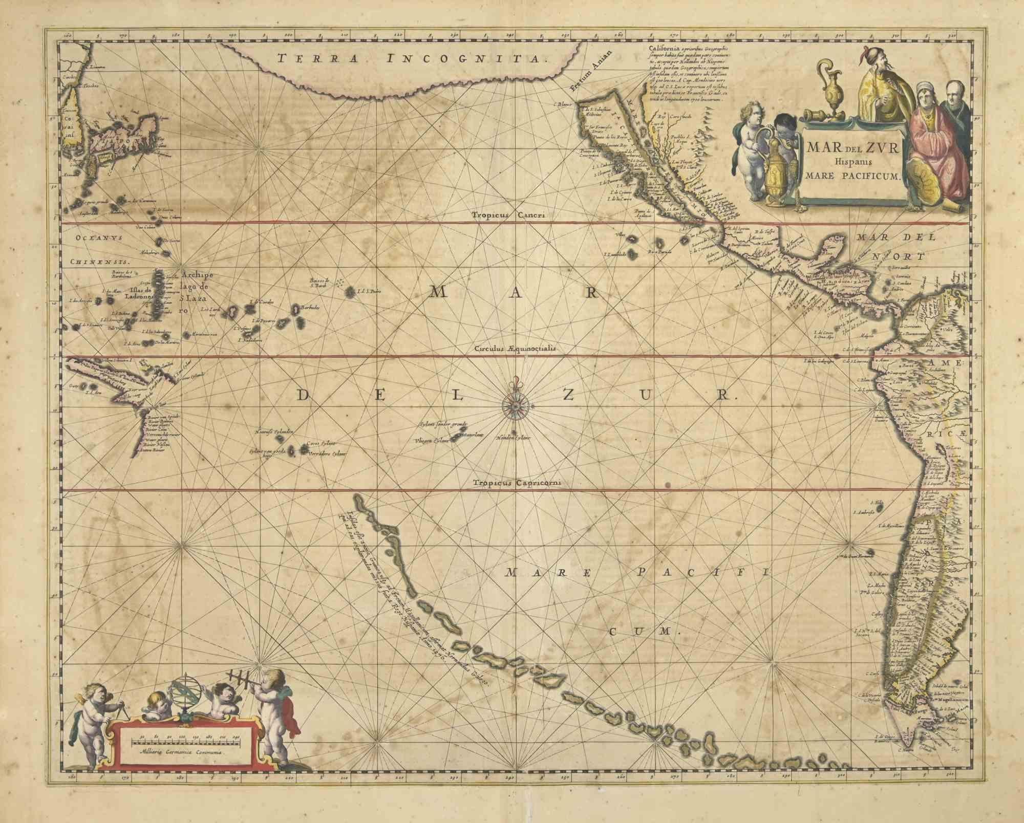
Antique Map - Mare Pacificum - Etching by Johannes Janssonius - 1650s
By Johannes Janssonius
Located in Roma, IT
Mare Pacificum is an antique map realized in 1650 by Johannes Janssonius (1588-1664).
The Map is Hand-colored etching, with coeval watercolorang.
Good conditions with slight foxing...
Category
1650s Modern Figurative Prints
Materials
Etching

Antique Map of the Spice Islands 'Moluccas', Indonesia by W. Blaeu, circa 1640
By Willem Blaeu
Located in Langweer, NL
Antique map titled 'Moluccae Insulae Celeberrimae'. Highly decorative antique map of the Spice Islands (Moluccas) published by W. Blaeu (circa 1640). This map features a large inset ...
Category
Antique Mid-17th Century Maps
Materials
Paper

Antique Map of the Maluku Islands by Blaeu, c.1640
Located in Langweer, NL
Antique map titled 'Moluccae Insulae Celeberrimae'. Decorative map of the Maluku Islands, also known as the Moluccas or the Spice Islands. Inset of the island of Bachian (Batjan) in ...
Category
Antique 17th Century Maps
Materials
Paper

$1,292 Sale Price
20% Off
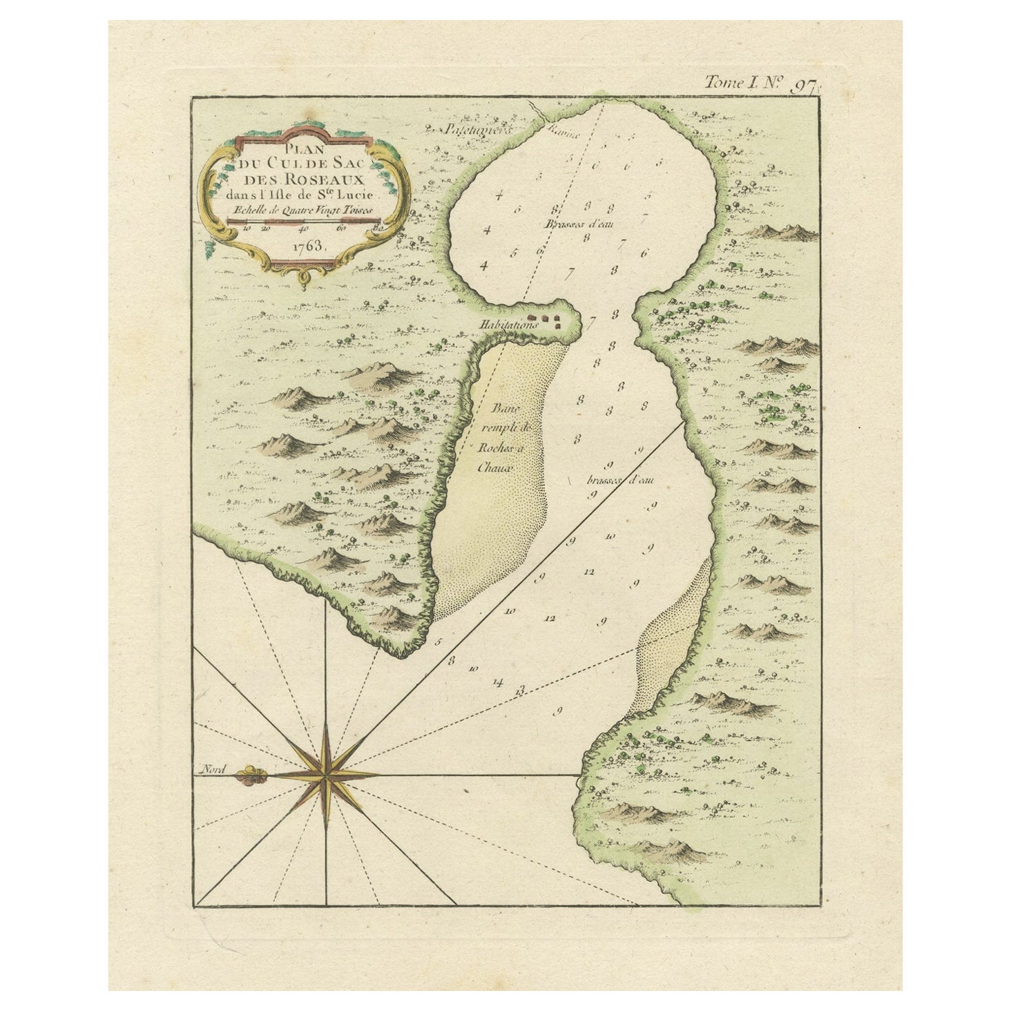
Roseaux, St. Lucia Island Map by BELLIN, Handcolored Engraving, 1763
Located in Langweer, NL
Dating back to around 1763, this antique hand-colored print, a creation by Jacques Nicolas Bellin, unveils a meticulously detailed "Plan du Cul de Sac des Roseaux dans l'Isle de Ste....
Category
Antique 1760s Maps
Materials
Paper
$277 Sale Price
20% Off
Antique Map - Gallia - Etching by Johannes Janssonius - 1650s
By Johannes Janssonius
Located in Roma, IT
Antique Map - Gallia is an antique map realized in 1650 by Johannes Janssonius (1588-1664).
The Map is Hand-colored etching, with coeval watercoloring.
Good conditions with slight ...
Category
1650s Modern Figurative Prints
Materials
Etching

Ancient Map - Zeilan - Etching by Johannes Janssonius - 1650s
By Johannes Janssonius
Located in Roma, IT
Ancient Map - Zeilan is an ancient map realized in 1650 by Johannes Janssonius (1588-1664).
The Map is Hand-colored etching, with coeval watercoloring.
...
Category
1650s Modern Figurative Prints
Materials
Etching

More Ways To Browse
Blaeu Maps
Miniature Maps
Antique Cross Ring
Antique Maps Virginia
John Speed Maps
John Speed Antique Maps
Bermuda Map
Gloucester Etching
Hawaiian Prints Webber
Hoshi Joichi
J Torrents Llado
Jean Solombre
Landscape Etchings Set
Margaret Martin
Milton Glaser Signed
Palm Tree Lithograph
Peter Max Sun
Peter Max Sunrise