Items Similar to Roman Hills, Aqueducts and Roads: An Early 18th Century Map by Jan Goeree

Want more images or videos?
Request additional images or videos from the seller
1 of 10
Jan GoereeRoman Hills, Aqueducts and Roads: An Early 18th Century Map by Jan Goeree1704
1704
$575
£433.94
€496.79
CA$810.94
A$890.31
CHF 464.48
MX$10,774.01
NOK 5,821.50
SEK 5,485.39
DKK 3,708.42
About the Item
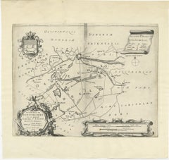
This richly engraved map of Rome and its environs entitled "Urbis Cum Vicis Seu Pagis Adiacentibus Dissertationi III De Aq et Aqueaed Veteris Promae Praemissa Authore Raph Fabretto Gast f. Urbinate" from Francois Desseine's Beschrijving van oud en niew Rome verdeelt in drie deelen. The work was engraved by Jan Goeree (1670-1731) and published by Francois Halma (1653-1722) in Amsterdam in 1704. The map appears mounted on a wall with a glimpse of architecture in the background on the left. A half naked female mythical god with an animal, possibly a greyhound, is seated in the left corner looking at two putti who hold open a book to the title page. Cartographic instruments and a linear scale are below the map to the right. The map depicts Rome with its seven hills (and one additional) to the left and above center, with many roads about the city, including Via Appia (the Appian Way) to the south. The Tiber River (Tiberis Fl.) and the many Roman aqueducts are also depicted.
This somewhat whimsical map of Rome is printed on laid, chain-linked paper with wide margins. The sheet measures 20.75" high and 24.75" wide. There is a vertical center fold, as issued and one small spot in the lower right margin of the map on the wall and another at the upper left edge of the sheet. It is otherwise in very good condition.
Francois Desseine was a Dutch librarian who authored the work 'Beschrijving van oud en niew Rome verdeelt in drie deelen' (Description of ancient and new Rome divided into three parts). It was a description of Rome, illustrated with numerous maps and engravings, depicting its people, customs, and architecture, etc.
Jan Goeree (1670-1731) was a Dutch artist, engraver, and art theorist, known for his prolific output of prints and drawings. He was born in Amsterdam and began his artistic training under the tutelage of his father, Willem Goeree, a famous art writer and publisher. Jan Goeree specialized in the production of prints, which were highly popular in his time, and he also created a large number of drawings and paintings. Goeree's work was highly influenced by the Dutch Golden Age, with its focus on realism, detail, and naturalism. He produced a wide variety of prints, including landscapes, genre scenes, and portraits, often working in collaboration with other artists. Goeree was also an important art theorist and published several influential books on art, including "Inleydinge Tot de Al-gemeene Teyken-Konst" (Introduction to the General Art of Drawing), which became a standard textbook for Dutch art schools in the 18th century. Despite his prolific output and influence, Goeree's reputation as an artist declined in the 19th century, and his work fell out of favor. However, in recent years, there has been renewed interest in his prints and drawings, and he is once again recognized as an important figure in Dutch art history.
- Creator:Jan Goeree (1670 - 1731, Dutch)
- Creation Year:1704
- Dimensions:Height: 20.75 in (52.71 cm)Width: 24.75 in (62.87 cm)
- Medium:
- Movement & Style:
- Period:
- Framing:Framing Options Available
- Condition:
- Gallery Location:Alamo, CA
- Reference Number:Seller: # 46781stDibs: LU1173211524512
About the Seller
5.0
Gold Seller
Premium sellers maintaining a 4.3+ rating and 24-hour response times
Established in 2011
1stDibs seller since 2019
291 sales on 1stDibs
Typical response time: 1 hour
- ShippingRetrieving quote...Shipping from: Alamo, CA
- Return Policy
Authenticity Guarantee
In the unlikely event there’s an issue with an item’s authenticity, contact us within 1 year for a full refund. DetailsMoney-Back Guarantee
If your item is not as described, is damaged in transit, or does not arrive, contact us within 7 days for a full refund. Details24-Hour Cancellation
You have a 24-hour grace period in which to reconsider your purchase, with no questions asked.Vetted Professional Sellers
Our world-class sellers must adhere to strict standards for service and quality, maintaining the integrity of our listings.Price-Match Guarantee
If you find that a seller listed the same item for a lower price elsewhere, we’ll match it.Trusted Global Delivery
Our best-in-class carrier network provides specialized shipping options worldwide, including custom delivery.More From This Seller
View AllSouthern Holland: An Original 17th C. Hand-colored Visscher Map "Hollandiae"
By Nicolaus Visscher
Located in Alamo, CA
This a beautiful framed hand colored 17th century map of the southern portions of Holland by Nicolaus (Nicolas) Visscher II entitled "Hollandiae pars Meridionalis, vulgo Zuyd-Holland", published in Amsterdam in 1678. The map shows the region between Breda, Heusden, Gornichem, Gouda, Dordrecht, and Willemstad. It includes a decorative cartouche in the lower left corner.
The map is presented in an attractive maple colored wood frame with gold trim and a fabric mat. There is a central vertical fold, as issued. There are small areas of discoloration consistent with age. The map is otherwise in very good condition.
The Visscher family were one of the great cartographic families of the 17th century. Begun by Claes Jansz Visscher...
Category
Late 17th Century Other Art Style Landscape Prints
Materials
Engraving

17th Century Dutch Map of the Holy Land at the Time of Jesus by Visscher
By Nicolaus Visscher
Located in Alamo, CA
This detailed Dutch map entitled "Het Beloofe de Landt Canaan door wandelt van onsen Salichmaecker Iesu Christo, nessens syne Apostelen" by Nicolaes Visscher (1610-1679), published i...
Category
1660s Prints and Multiples
Materials
Engraving

Utrecht, Netherlands: A Large 17th Century Hand-colored Map by Sanson & Jaillot
By Nicholas Sanson d'Abbeville
Located in Alamo, CA
This large hand-colored map entitled "La Seigneurie d'Utrecht. Dressé sur les memoires les plus nouveaux par le Sr. Sanson" was originally created by Nicholas Sanson d'Abbeville. Thi...
Category
1690s Landscape Prints
Materials
Engraving

Meissen, Germany : A Large Framed 18th Century Map by Petrus Schenk
Located in Alamo, CA
This is a hand-colored 18th century map of the Meissen region of Germany, entitled "Geographischer Entwurff Derer Aemmter Meissen als Creys-Procuratur-Schul-und Stiffts-Ammt benebst ...
Category
Mid-18th Century Old Masters Landscape Prints
Materials
Engraving

L'Isle de France: A Hand-colored 17th Century Map by De Wit
By Frederick de Wit
Located in Alamo, CA
This colorful and detailed 17th century hand-colored copperplate map by Frederick De Wit was published in Amsterdam between 1666 and 1760. The map depicts the Île-de-France, which is one of the ancient provinces of France. Paris is located in the center of the map, with Versailles to the southwest The map extends from Rouen in the west to Reims in the east. The area around Paris, the Véxin Français, was the original domain of the king of France. Other areas were ruled by French feudal lords. For example, the Véxin Normand area was the domain of the Duke of Normandy...
Category
Early 18th Century Old Masters More Prints
Materials
Engraving

West Germany: Original Hand Colored 17th Century Map by Johannes Janssonius
By Johannes Janssonius
Located in Alamo, CA
An original hand colored copperplate engraved map entitled in Latin "Archiepiscopatus Maghdeburgensis et Anhaltinus Ducatus cum terris adjacentibus", published in Amsterdam in 1640 i...
Category
Mid-17th Century Old Masters More Prints
Materials
Engraving

You May Also Like
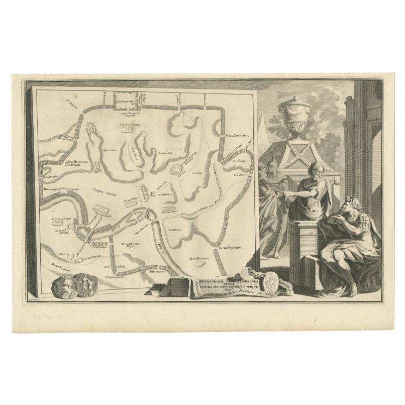
Old Map of Ancient Rome Illustrating Major Monuments and the Seven Hills, c.1704
Located in Langweer, NL
Antique map Rome titled 'Omnia Romanae cedant Miracula Terrae (..)'. Map of Ancient Rome Illustrating Major Monuments and the Seven Hills. This map or...
Category
Antique 18th Century Maps
Materials
Paper
$366 Sale Price
20% Off
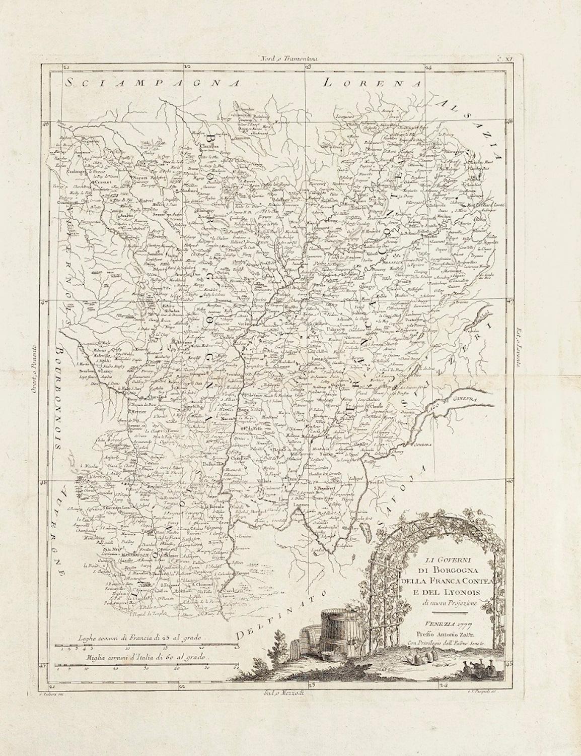
Li Governi di Borgogna - Ancient Map - 1777
Located in Roma, IT
Li Governi di Borgogna is an original black and white etching on paper, printed by Antonio Zatta in Venice, 1777.
Original Title: Li Governi di Borgogna della Franca Contea e del Ly...
Category
1770s Modern Landscape Prints
Materials
Etching

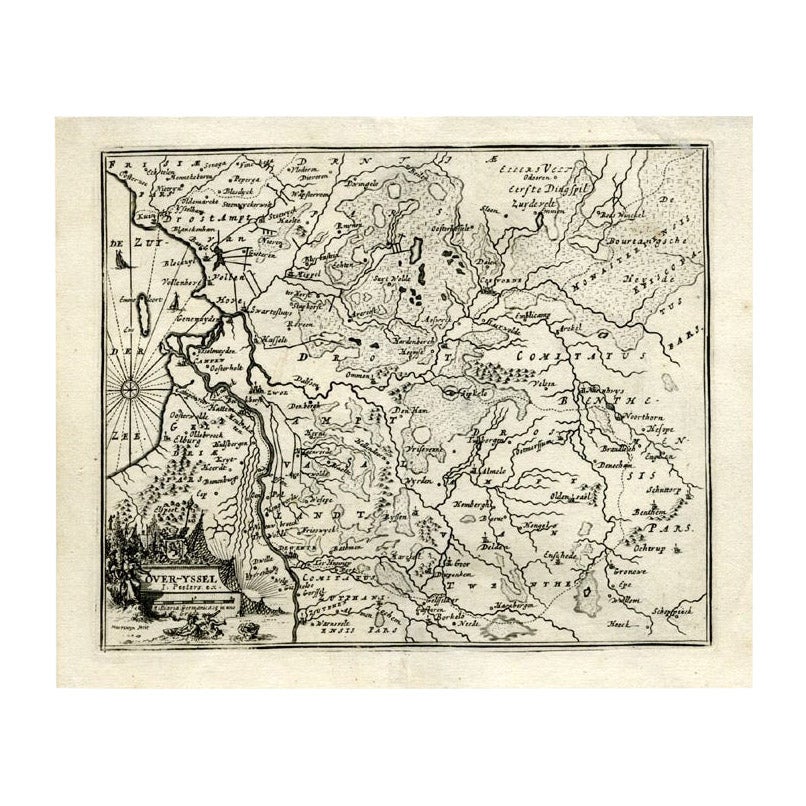
Antique Map of Overijssel by Bachiene, 1758
Located in Langweer, NL
Antique map titled 'Over-Yssel'. Map of the Overijssel, the Netherlands. This map originates from 'Kort begrip der Oude en Nieuwe Staatkundige Geographie', by W.A. Bachiene, publishe...
Category
Antique 18th Century Maps
Materials
Paper
$163 Sale Price
20% Off
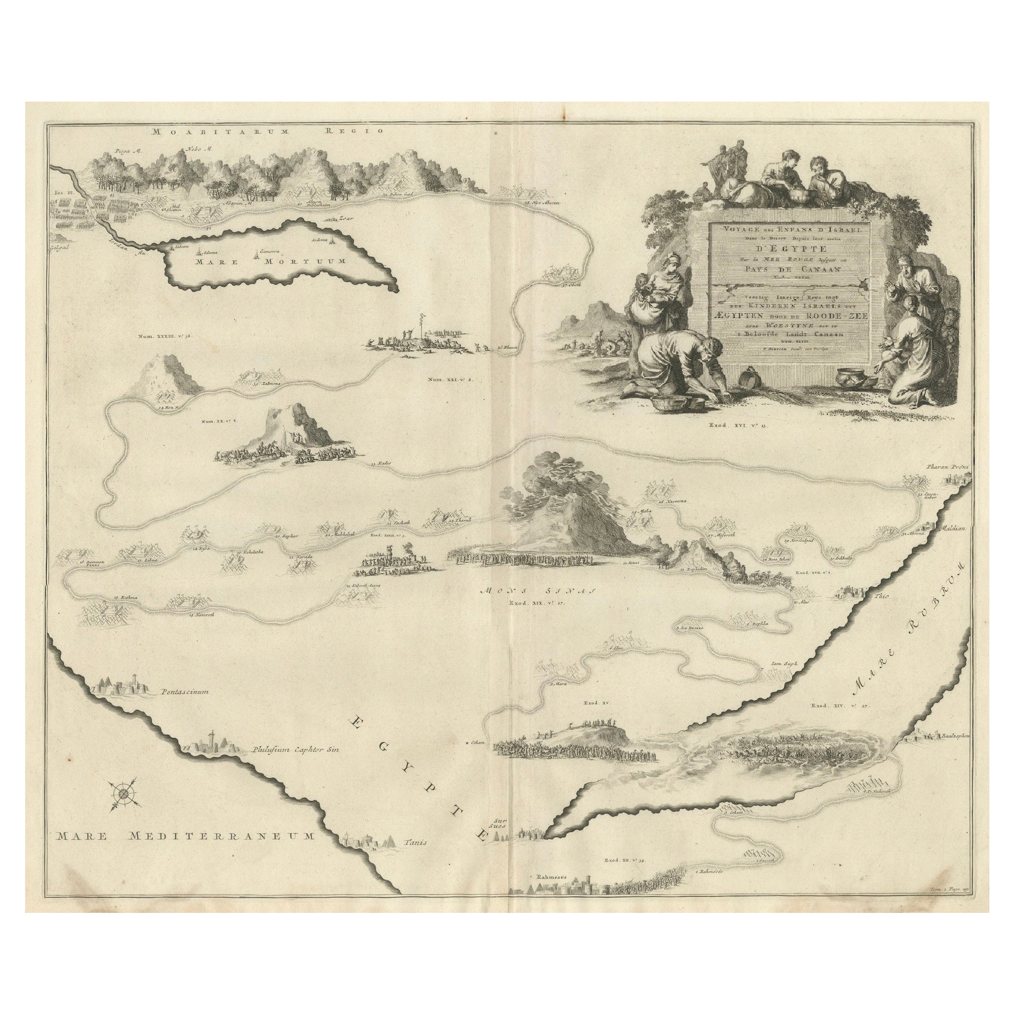
Decorative Map of the Holy Land, Wanderings of Moses by Pieter Mortier, ca. 1700
Located in Langweer, NL
Decorative Map of the Holy Land, Wanderings of Moses by Pieter Mortier, ca. 1700
Antique decorative map of the Holy Land depicting the Exodus of Moses and the Children of Israel fro...
Category
Antique Early 1700s Dutch Maps
Materials
Paper
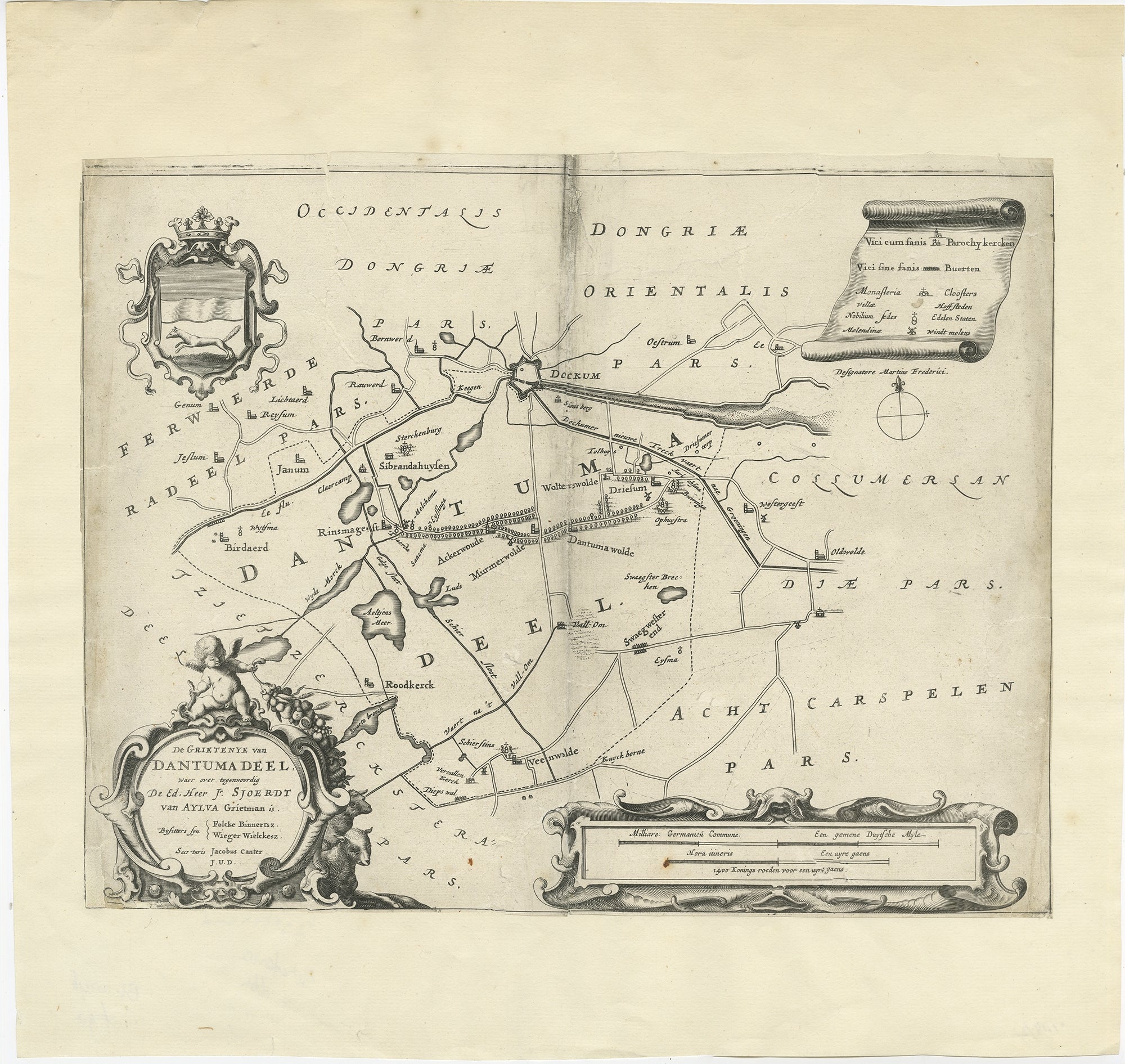
Antique Map of the Region of Dantumadeel by Schotanus, 1664
Located in Langweer, NL
Antique map titled 'De Grietenye van Dantumadeel (..)'. Map of the Grietenij of Dantumadeel, Friesland, The Netherlands. Originates from "Beschrijvinge ende nieuwe caerten van de Hee...
Category
Antique 17th Century Maps
Materials
Paper
Antique Map of Overijssel by Van Jagen, 1771
Located in Langweer, NL
Antique map titled 'L'Over-Issel'. This map depicts the Dutch province Overijssel. This map originates from 'Nouvel Atlas, très exact et fort commode pour toutes sortes de personnes,...
Category
Antique 18th Century Maps
Materials
Paper

$183 Sale Price
20% Off
More Ways To Browse
Antique Print Of Rome
Roman Engravings
Antique Roman Map
St Andrews Prints
Tanna Kasimir
Van Rheede
Waterloo Anthonie
Axis Mundi
Banksy Walled Off Hotel
Banksy Walled Off
Cartier Poster
Dali Butterfly Suite
David Hockney Red
David Roberts Petra
Earlom Mezzotint
Ernest Roth Etching
Galerie 65 Cannes
Gloucester Etching