Items Similar to AMERICA
Want more images or videos?
Request additional images or videos from the seller
1 of 10
John SpeedAMERICA1626-76
1626-76
$4,080
$8,50052% Off
£3,143.53
£6,549.0152% Off
€3,590.89
€7,481.0152% Off
CA$5,841.23
CA$12,169.2452% Off
A$6,371.04
A$13,27352% Off
CHF 3,349.83
CHF 6,978.8252% Off
MX$76,455.29
MX$159,281.8552% Off
NOK 42,295.30
NOK 88,115.2152% Off
SEK 39,449.98
SEK 82,187.4652% Off
DKK 26,818.66
DKK 55,872.2152% Off
About the Item
IMPORTANT AMERICAN MAP - ONE OF THE FIRST TO SHOW CALIFORNIA as an ISLAND
JOHN SPEED (1552-1629)
AMERICA - With Those Known Parts In That Unknown Worlde (sic),
1626-(76)
(Burden 217 iv/iv) Engraving, uncolored. Engraved by Abraham Goos and
published by Thomas Basset and Richard Chiswell - 4th state of 4 in 1676
15 1/8 x 20 1/2” From “A Prospect of the Most Famous Parts of the
World”. Generally good condition. A repaired split in lower centerfold. This
is the most common version of this important map. One of the earliest
maps to show California as an Island and the first in an atlas. $8,500
Southwest, American Historical, Maps, Ships, Exploration
- Creator:John Speed (1552 - 1629)
- Creation Year:1626-76
- Dimensions:Height: 15.125 in (38.42 cm)Width: 20.5 in (52.07 cm)
- Medium:
- Movement & Style:
- Period:1620-1629
- Condition:
- Gallery Location:Santa Monica, CA
- Reference Number:1stDibs: LU41131940163
About the Seller
5.0
Recognized Seller
These prestigious sellers are industry leaders and represent the highest echelon for item quality and design.
Platinum Seller
Premium sellers with a 4.7+ rating and 24-hour response times
Established in 1977
1stDibs seller since 2016
296 sales on 1stDibs
Typical response time: 1 hour
Associations
International Fine Print Dealers Association
- ShippingRetrieving quote...Shipping from: Santa Monica, CA
- Return Policy
More From This Seller
View AllNew Map of the Terraqueous Globe - WORLD MAP - CALIFORNIA AS AN ISLAND
By Edward Wells
Located in Santa Monica, CA
EDWARD WELLS (British 1667- 1727)
A NEW MAP of the TERRAQUEOUS GLOBE - according to the latest Discoveries and most general Divisions of it into CONTINENTS and OCEANS, 1700-01 (Shirley 609)
Engraved by Michael Burghers, Oxford. Hand-colored, Platemark 14 1/4 x 20 1/8 inches. Central cartouche flanked by figures representing the continents with dedication to William, Duke of Gloucester...
Category
Early 1700s Old Masters Landscape Prints
Materials
Engraving

AMERICAE - Sive Novi Orbis, Nova Descriptio
By Abraham Ortelius
Located in Santa Monica, CA
ABRAHAM ORTELIUS (1527 - 1598)
AMERICAE SIVE NOVI ORBIS, NOVA DESCRIPTIO, 1587 (1603) (Van Den Broecke 11, Burden 64; Schwartz & Ehrenberg 69)
Engraving. A very good, well printed...
Category
16th Century Old Masters Landscape Prints
Materials
Engraving

PERU
By Johannes Jansson
Located in Santa Monica, CA
JOHANNES JANSSON (1588 - 1664)
PERU, engraving with early coloring. Platemark 15 1/8 x 19 3/8 inches, sheet 17 x 20 1/2
A nice example of one of the earliest maps of Peru. From the ...
Category
1630s Old Masters Landscape Prints
Materials
Engraving

WORLD MAP - Planisphaerium Terrestre Sive Terrarum Orbis... 1696
By Carel Allard
Located in Santa Monica, CA
CAREL ALLARD (1648 – 1709)
PLANISPHAERIUM TERRESTRE SIVE TERRARUM ORBIS… 1696 (Shirley 578)
Engraving, 20 ½ x 23 ½”, sheet 21 x 24 1/8". A stunning double hemisphere World Map...
Category
17th Century Old Masters Landscape Prints
Materials
Engraving

SURREALIST LANDSCAPE
By Edward Hagedorn
Located in Santa Monica, CA
EDWARD HAGEDORN (AMERICAN 1902 – 1982)
SURREAL LANDSCAPE 1931 mixed media on paper, Graphite, ink and watercolor. Unsigned. Dtaed 2/26/31, in ink lower left margin. Image 13 3/4 x 16 1/2 inches. On a large sheet 20 x 25 inches.
Provenance: Hagedorn estate, Around the mid 1980's The Hagedorn estate was dispersed in Berkeley by a local dealer. This drawing was part of a group of Hagedorn works on paper that I acquired from that dispersal. Much of the balance was later acquired the Struart Denenberg Fine Art.
Denenberg published a very fine book on the artist's work.
EDWARD HAGEDORN: CALIFORNIA MODERNIST, RESTLESSNESS AND RESTRAINT Hardcover – January 1, 2009
Subsequently Hagedorn's works on paper have been acquired by many museums and some accompanying exhibitions.
ALL OF THE COMMENTS BELOW ARE FROM THE FOLLOWING EXHIBITION
EDWARD HAGEDORN (1902-1982)
American Modernist
A New Traveling Exhibition
“VOLCANOS, WRECKS, RIOTS, & NUDES”, EDWARD HAGEDORN (1902-1982)
premiere at the Danforth Museum. Framingham, MA, in March 2016. The exhibition includes 75 works of art in various mediums and is accompanied by the first monograph devoted to the artist’s work with essays by leading curators, critics, and art historians.
Edward Hagedorn was a true Modernist who created a trove of powerful works on paper--drawings, watercolors, oils, and original graphics that reveal the hand of a master draftsman and the mind of an astute political observer. He rejected the general trend in early 20th century California of local landscapes and coastal views, becoming virtually the single voice of Expressionism. He conveyed the darkness and upheaval that gripped the country in the depression years between the two World Wars, 1925- 1935, more forcefully than any of his contemporaries, influenced by German art of the time, engaging in modernist styles of Expressionism and Surrealism.
Hagedorn’s skeletons are ferocious yet somehow endearing; printed in deep black ink on off-white paper, they march across Lilliputian landscapes of grim disorder and destruction. Comets and volcanoes explode in fauvist colors, their other-worldly fluorescent temperas framed in black, while nude female figures, executed in exquisitely refined pen and ink, or graphite line drawings, are as economical in their means as Matisse, and can be compared with the neo-classical drawings of Picasso. Among his most lyrical works of the 1920s is a series of rhythmically abstracted watercolor and ink views of Golden Gate Park, evoking the sensual demi-geometries of Balthus, Derain , and early Mondrian.
American Modernist Edward Hagedorn (1902-1982) was born in San Francisco of German descent; his mother (née Kafka) died in childbirth, and he was legally adopted and raised by his grandmother and aunt. After attendance at the San Francisco School of Fine Arts in the early 1920s, by age 22 he had a studio in the famed "100" block of Montgomery Street ("the Monkey Block,") then a haven for bohemians.
In 1926, a year of tremendous importance in California artists' embrace of modern art, the Oakland Art Gallery, with the guidance and inspiration of their European representative Emmy (Galka) Scheyer, was the first museum in the United States to show the art of the "Blue Four," among the leading artists of International Modernism--Paul Klee, Lyonel Feininger, Alexei Jawlensky...
Category
1930s American Modern Mixed Media
Materials
Watercolor
$3,000 Sale Price
33% Off
COMPOSITION - Lovely design portraying a future Abstract Expressionist.
Located in Santa Monica, CA
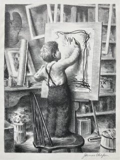
JAMES CHAPIN (1887 – 1975)
COMPOSITION c. 1940
Lithograph signed in pencil, Image 11 7/8 x 7 ¾ inches, sheet 13 5/8 x 10 5/8 inches. Just a hint of mat line in the margins and on the verso. Some remnants of old tape prImarily at the left & right sheet edges. Rather scarce print but possibly published by Associated American Artists.
WONDERFUL PORTRAYAL OF AN UP AND COMING ARTIST...
Category
1940s American Modern Figurative Prints
Materials
Lithograph
You May Also Like
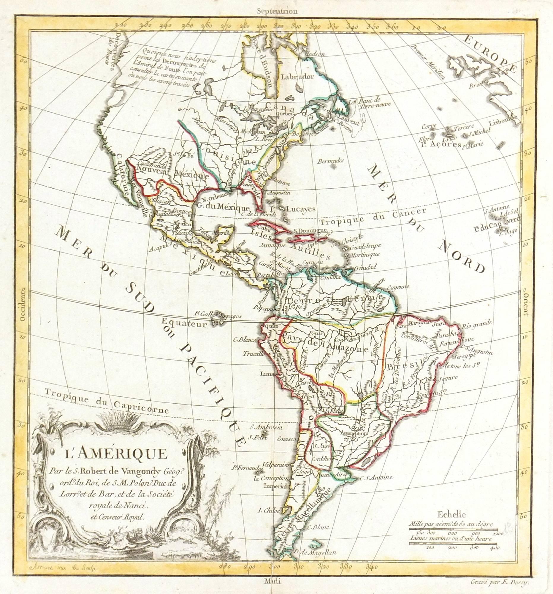
Map of Americas
Located in Houston, TX
Over 200 year old engraved map of Americas by Robert de Vaugondy from 1783. Original hand color. Shows North, Central and South Americas. Note the po...
Category
1780s More Prints
Materials
Ink, Watercolor, Handmade Paper

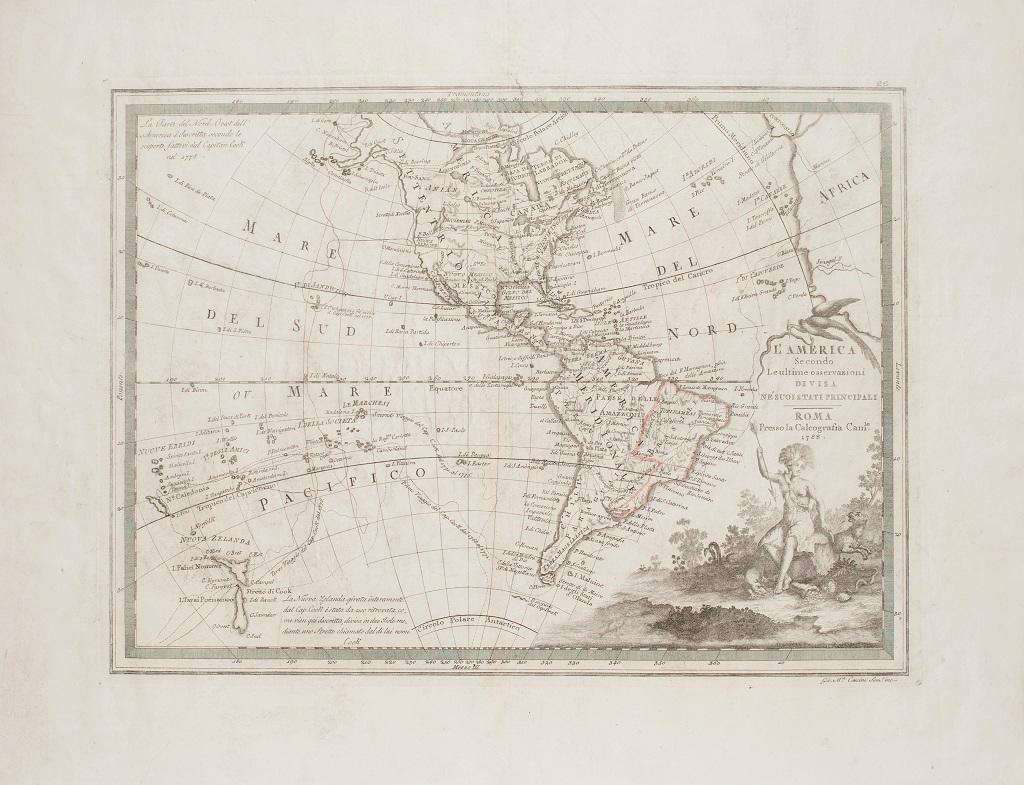
The Americas - Vintage Map - 18th century
Located in Roma, IT
The Americas is a very beautiful vintage map realized in the 18th century by an Italian cartographer.
Very good conditions, on the right side the inscript...
Category
18th Century Figurative Prints
Materials
Paper, Etching

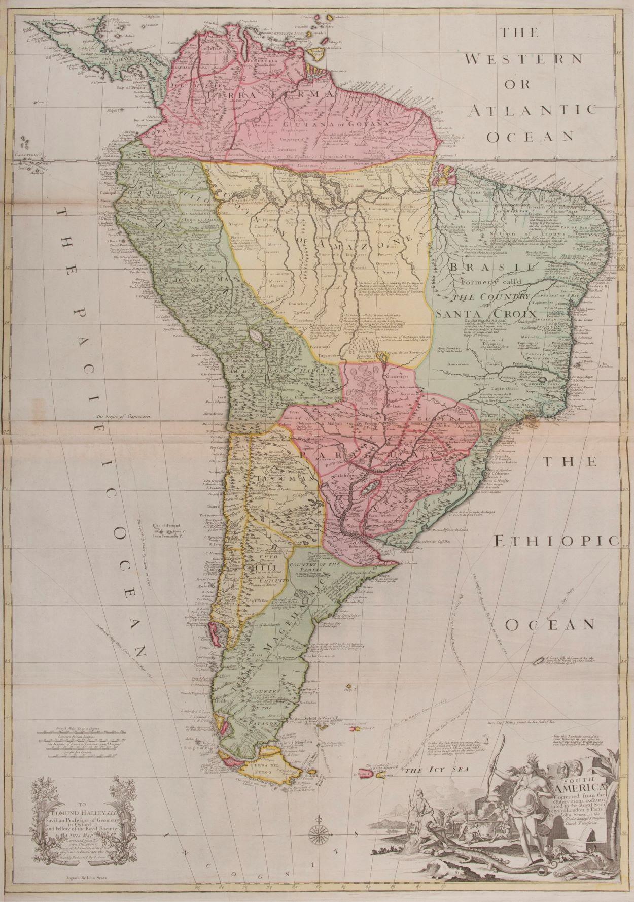
South America
By John Senex
Located in London, GB
South America
SENEX, John.
South America Corrected from the Observations Communicated to the Royal Society’s of London & Paris. By John Senex. To Edmund Halley. LLD. Savilian Professor of Geometry in Oxford and Fellow of the Royal Society. This Map corrected from His own Discoveries In gratefull Acknowledgement of his Ready assistance to Encourage this Designe is Humbly Dedicated.
John Senex, at the Globe against St Dunstans Church, Fleetstreet, London 1710 [-1728].
John Senex (1678-1740) was one of the foremost mapmakers in England in the early eighteenth century. He was also a surveyor, globemaker, and geographer. As a young man, he was apprenticed to Robert Clavell, a bookseller. He worked with several mapmakers over the course of his career, including Jeremiah Seller and Charles...
Category
1710s Naturalistic More Art
Materials
Watercolor, Engraving
$4,051
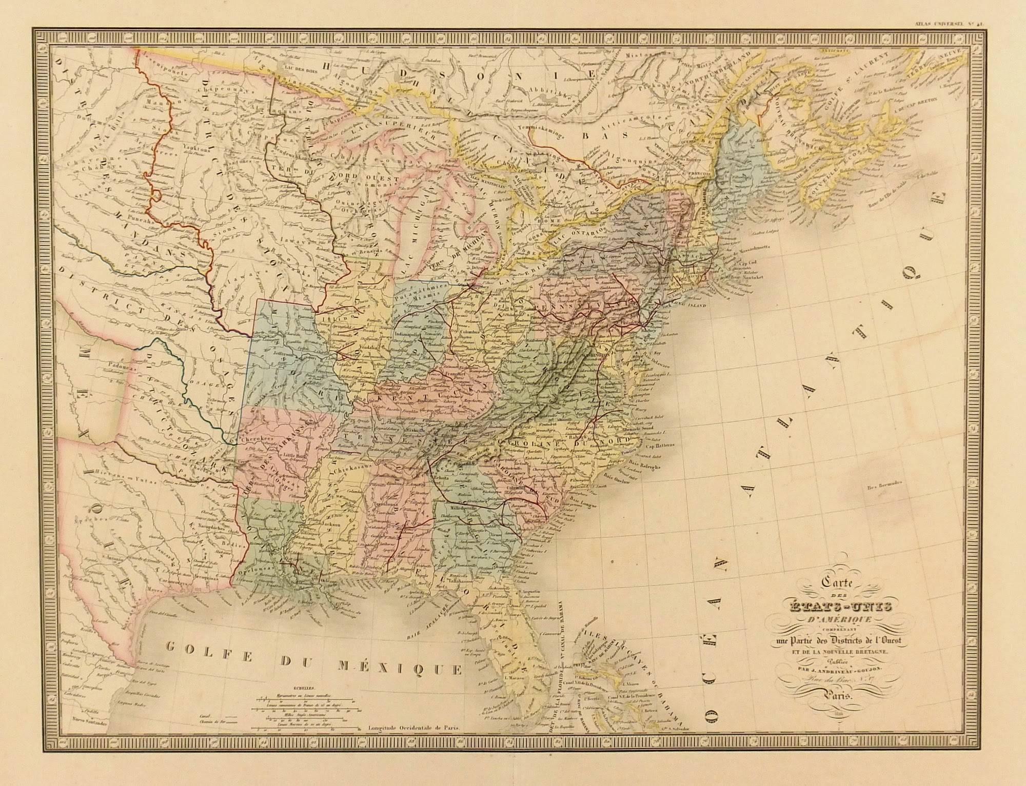
United States, 1844
Located in Houston, TX
Over 150 year old map of early United States of America with Western Districts from 1844. Original hand color. Districts shown include Hurons, Sioux, Mandans, Osages, and Ozark. Note independent Republic of Texas...
Category
1840s More Prints
Materials
Ink, Watercolor, Handmade Paper
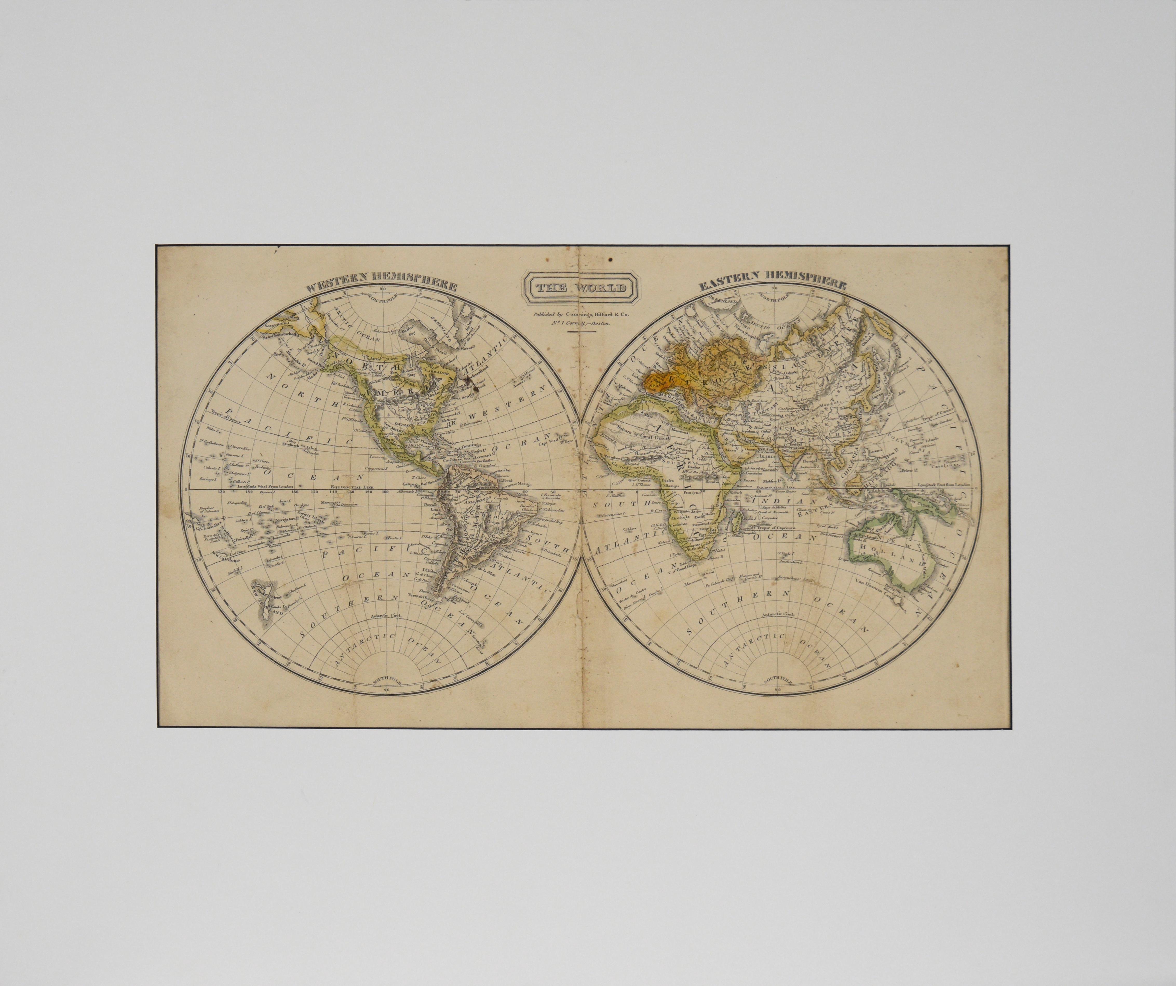
"The World" Published by Cummings & Hilliard, No. 1, Cornhill, Boston
Located in Soquel, CA
"The World" Published by Cummings & Hilliard, No. 1, Cornhill, Boston
Early 19th century engraved double hemisphere Atlas Map, titled "The World." Hand colored original outlines. Pu...
Category
1820s American Realist Landscape Prints
Materials
Paper, Printer's Ink, Etching
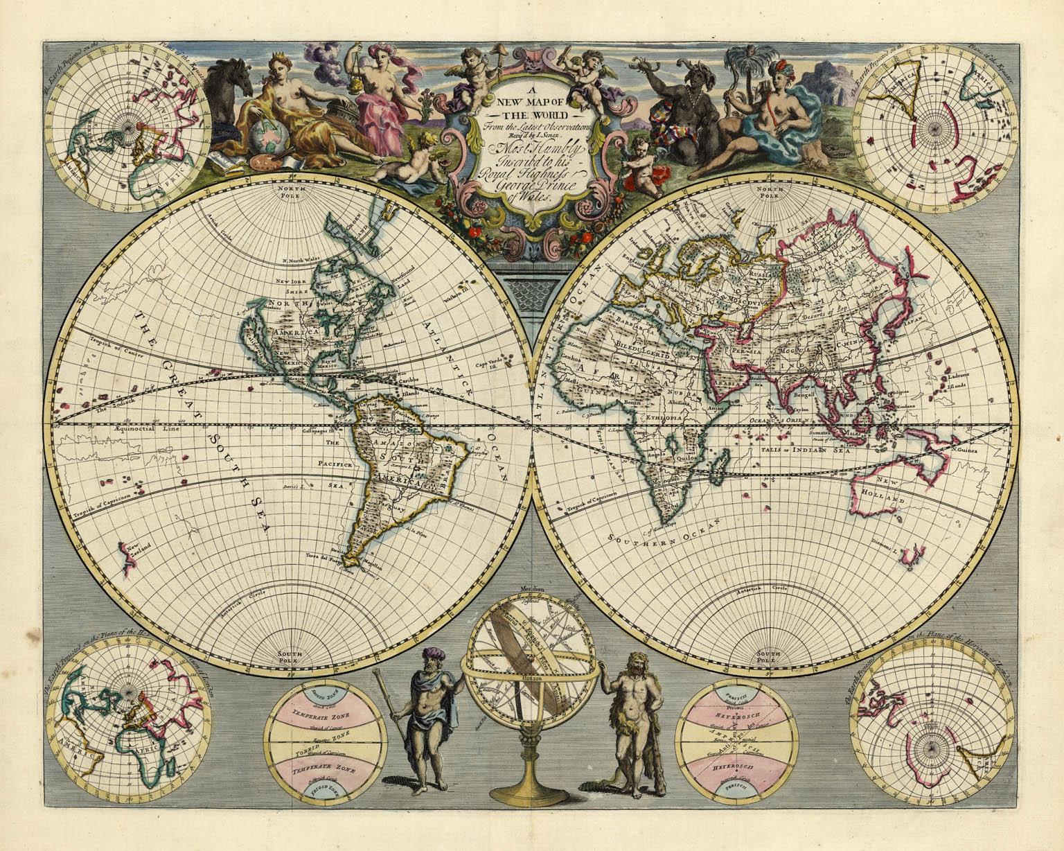
A NEW MAP OF THE WORLD from the Latest Observations.
By John Senex
Located in New York, NY
The title continues “…. Most Humbly Inscribd [sic] to his Royal Highness George Prince of Wales.”
A fine British produced double hemisphere world map. On this map, California is shown as an island on the main double hemisphere map...
Category
18th Century Other Art Style More Prints
Materials
Watercolor, Engraving