Items Similar to Vintage Geographic Splendor: 1859 Spain and Portugal


Want more images or videos?
Request additional images or videos from the seller
1 of 6
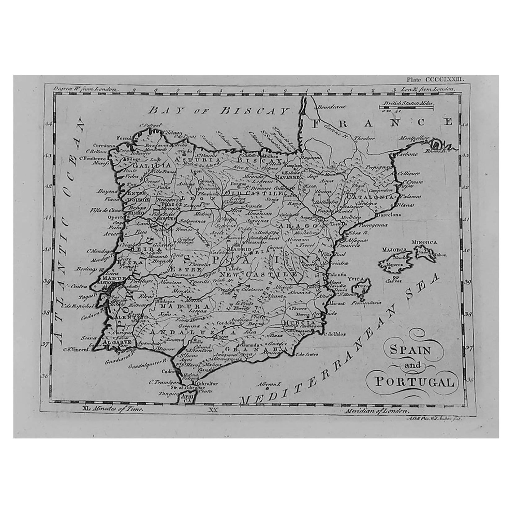
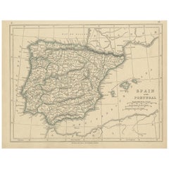
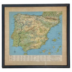
Vintage Geographic Splendor: 1859 Spain and Portugal
About the Item
The "Vintage Geographic Splendor: 1859 Spain and Portugal" map is an original antique piece from 'The Imperial Atlas of Modern Geography', published by W. G. Blackie in 1859. This map is a detailed representation of the Iberian Peninsula, showcasing Spain and Portugal during the mid-19th century.
**Key Features of the Map:**
1. **Geographical Detail**: The map encompasses the entire Iberian Peninsula, meticulously detailing the varied landscapes of Spain and Portugal. It highlights mountain ranges like the Pyrenees and Sierra Nevada, major rivers such as the Tagus and Ebro, and the distinct coastlines along the Atlantic Ocean and the Mediterranean Sea.
2. **Political Boundaries**: Reflecting the political divisions of the time, the map delineates the separate kingdoms, regions, and provinces within Spain and Portugal, providing insight into the territorial organization of the Iberian nations in the 1850s.
3. **Urban Centers**: Major cities and towns are accurately marked, including Madrid, Lisbon, Barcelona, and Porto. The map likely indicates the important cultural and economic centers, offering a glimpse into the urban landscape of 19th-century Spain and Portugal.
4. **Transportation and Trade Routes**: The map may illustrate historical trade routes, roads, and possibly railway lines, highlighting the connectivity and economic activity within and between Spain and Portugal.
5. **Artistic Elements**: True to the cartographic style of the Victorian era, the map likely features decorative embellishments, including ornate border designs and an elegant title script, enhancing its aesthetic appeal.
6. **Educational and Historical Value**: As a historical document, this map provides valuable insights into the geographical knowledge and perceptions of Spain and Portugal during the mid-19th century. It serves as an educational tool for understanding the historical geography of the Iberian Peninsula.
**Significance of 'The Imperial Atlas of Modern Geography':**
1. **Comprehensive Collection**: This atlas is known for its broad coverage, detailing various parts of the world with accuracy and detail characteristic of the era.
2. **Craftsmanship and Accuracy**: The maps in this collection were created with a high level of detail and craftsmanship, showcasing the advanced cartographic techniques of the time.
3. **Historical Importance**: As a part of 'The Imperial Atlas of Modern Geography', this map of Spain and Portugal holds significant historical value, representing the state of geographical knowledge during the Victorian era.
This antique map of Spain and Portugal is not only a collector's item for map enthusiasts but also a vital resource for historians, geographers, and anyone interested in the historical landscape of the Iberian Peninsula.
- Dimensions:Height: 14.57 in (37 cm)Width: 21.26 in (54 cm)Depth: 0.02 in (0.5 mm)
- Materials and Techniques:
- Period:
- Date of Manufacture:1859
- Condition:Wear consistent with age and use. General age-related toning. some foxing, Please study image carefully.
- Seller Location:Langweer, NL
- Reference Number:Seller: BG-12685-1-341stDibs: LU3054325240402
About the Seller
5.0
Platinum Seller
These expertly vetted sellers are 1stDibs' most experienced sellers and are rated highest by our customers.
Established in 2009
1stDibs seller since 2017
1,940 sales on 1stDibs
Typical response time: <1 hour
- ShippingRetrieving quote...Ships From: Langweer, Netherlands
- Return PolicyA return for this item may be initiated within 14 days of delivery.
Auctions on 1stDibs
Our timed auctions are an opportunity to bid on extraordinary design. We do not charge a Buyer's Premium and shipping is facilitated by 1stDibs and/or the seller. Plus, all auction purchases are covered by our comprehensive Buyer Protection. Learn More
More From This SellerView All
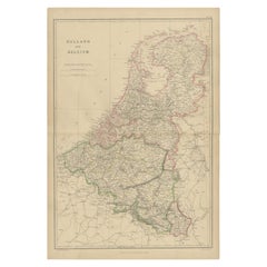
- 1859 Vintage Map of Holland and Belgium: Blackie's Imperial Geographic InsightLocated in Langweer, NLThe "Antique Map of Holland and Belgium" from 'The Imperial Atlas of Modern Geography', published by W. G. Blackie in 1859, is a significant hi...Category
Antique Mid-19th Century Maps
MaterialsPaper
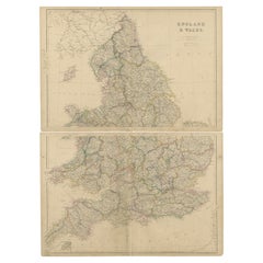
- 1859 Vintage Maps of England and Wales: Blackie's Imperial Geographic DetailLocated in Langweer, NLThe "Antique Map of England & Wales" from 'The Imperial Atlas of Modern Geography', published by W. G. Blackie in 1859, is an original antique map that provides a detailed depiction ...Category
Antique Mid-19th Century Maps
MaterialsPaper
- 1859 Classic Map of France: Blackie's Imperial Geographic MasterpieceLocated in Langweer, NLThe "Antique Map of France" from 'The Imperial Atlas of Modern Geography', published in 1859 by W. G. Blackie, is a historically valuable cartographic work that offers a comprehensiv...Category
Antique Mid-19th Century Maps
MaterialsPaper
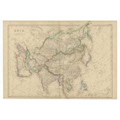
- Original 1859 Map of Asia from W.G. Blackie's Imperial Atlas of Modern GeographyLocated in Langweer, NLAntique map titled 'Asia'. Original antique map of Asia. This map originates from ‘The Imperial Atlas of Modern Geography’. Published by W. G. Blackie, 1859. The "Classic Cartograph...Category
Antique Mid-19th Century Maps
MaterialsPaper
- Antique Decorative Map of Portugal and Spain, 1842Located in Langweer, NLAntique map titled 'Carte de la Peninsule comprenant l'Espagne et le Portugal'. Map of Spain and Portugal. This map originates from 'Atlas universel de géographie ancienne et mod...Category
Antique 1840s Maps
MaterialsPaper
- Antique Map of Spain and Portugal by Lowry, '1852'Located in Langweer, NLAntique map titled 'Spain and Portugal'. Original map of Spain and Portugal. This map originates from 'Lowry's Table Atlas constructed and engraved ...Category
Antique Mid-19th Century Maps
MaterialsPaper

You May Also Like
- 18th Century Hand Colored Map of Spain and Portugal by VisscherBy Nicolaes Visscher IILocated in Alamo, CAThis is an early 18th century map of Spain and Portugal, with attractive original hand-coloring, entitled "Hispaniae et Portugalliae Regna per Nicolaum Visscher cum Privilegio Ordinu...Category
Antique Early 18th Century Dutch Maps
MaterialsPaper
- Large Antique 1859 Map of North AmericaLocated in Sag Harbor, NYThis Map was made by Augustus Mitchell in 1859 It is in amazing condition for being 163 years old. This price is for the rolled up easy to ship version of this piece. I will be Frami...Category
Antique Mid-19th Century American Maps
MaterialsCanvas, Paper

- Portugal: A Large 17th Century Hand-colored Map by Sanson and JaillotBy Nicolas SansonLocated in Alamo, CAThis large hand-colored map entitled "Le Royaume de Portugal et des Algarves Divisee en see Archeveches, Eveches et Territoires Par le Sr Sanson" was originally created by Nicholas S...Category
Antique 1690s French Maps
MaterialsPaper
- Vintage Framed Print of Spain, Canary Islands and Portugal, FramedLocated in Miami, FLVintage Framed Print of Spain, Canary Islands and Portugal, Framed Offered for sale is a vintage framed print of a map of Spain, the Canary Islands, and Portugal. The maps show som...Category
20th Century European Prints
MaterialsWire
- 17th Century Hand-Colored Map of Valencia and Murcia, Spain by Mercator/HondiusBy Gerard MercatorLocated in Alamo, CAA 17th century hand-colored map entitled "Regni Valentiae Typus, Valentia and Murcia" by Gerard Mercator and Joducus Hondius, published in Amsterdam in 1635 in 'Cosmographicall Descr...Category
Antique Mid-17th Century Dutch Maps
MaterialsPaper
- Spanish Splendor Great Palaces Castles and Country Homes Hardcover Book RizzoliBy Rizoli International PublicationsLocated in North Hollywood, CASpanish Splendor: Great Palaces, Castles, and Country Homes hardcover book. y Mato, Juan Jose Junquera (text by); Schezen, Roberto (photographs by); y Morenes, Enrique Ruspoli (intro...Category
20th Century Spanish Moorish Books
MaterialsPaper


Recently Viewed
View AllMore Ways To Browse
Map Spain
Maps Spain
Map Of Spain
Antique Map Spain
Antique Maps Spain
Antique Spain Map
Spain Antique Map
Antique Maps Of Spain
Antique Map Of Spain
Portugal Map
Map Of Portugal
Antique Map Of Portugal
Antique Map Portugal
Antique Maps Of Islands
18th Russian
Antique Maps Of Holland
Antique Maps Of America
Antique Map Of America