Items Similar to 18th-Century Biblical Map of the Colonies of Ham: Africa, Middle East and Beyond

Want more images or videos?
Request additional images or videos from the seller
1 of 7
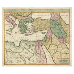
18th-Century Biblical Map of the Colonies of Ham: Africa, Middle East and Beyond
$267.82
$334.7720% Off
£198.27
£247.8320% Off
€224
€28020% Off
CA$370.59
CA$463.2420% Off
A$408.57
A$510.7120% Off
CHF 213.75
CHF 267.1920% Off
MX$5,012.40
MX$6,265.5020% Off
NOK 2,690.70
NOK 3,363.3720% Off
SEK 2,516.23
SEK 3,145.2920% Off
DKK 1,706.29
DKK 2,132.8720% Off
About the Item
This map, titled "A Map of the Colonies of the Descendants of Ham," dates to around 1790. It illustrates regions in Africa, the Middle East, and parts of Europe that were traditionally believed to be settled by the descendants of Ham, one of Noah's sons, according to the Book of Genesis and to biblical tradition.
The map's style, with speculative geographic features, is reminiscent of the work of the polymath Athanasius Kircher. It was created for an English biblical history and likely drawn by Lodge. This map reflects early cartographic attempts to merge religious stories with geographic understanding.
### Key Features and Analysis:
1. Regions Depicted:
- North Africa: The map shows the regions of Mauritania, Carthage, Numidia, and "Africa Propria." These areas align with modern-day North Africa, including Libya, Tunisia, and parts of Algeria.
- Egypt and Ethiopia: The map highlights Egypt and regions labeled "Ludim or Ethiopia," which corresponds to ancient Cush. The Red Sea and the Nile River are prominently depicted, emphasizing their significance in ancient history and biblical narratives.
- Persia and Mesopotamia: Mesopotamian cities like Nineveh and Babel (Babylon) are marked, along with Persia, underlining their importance in biblical accounts.
- Arabian Peninsula: The Arabian Peninsula is labeled with places such as Sheba and Seba, areas famously connected to the Queen of Sheba in biblical texts.
- Southern Europe: Parts of Southern Europe, such as Iberia (Spain) and regions around the Mediterranean, are shown as the extent of these "colonies."
2. Colonies of Ham:
According to biblical tradition, the descendants of Ham are thought to have settled in Africa and parts of the Middle East, and this map reflects the traditional geographic distribution based on religious interpretations. Ham's sons, such as Cush, Mizraim (Egypt), and Phut, are represented by the areas where their descendants were believed to have settled.
3. Map Aesthetic:
The map uses a simplistic style with soft pastel colors to differentiate regions. The place names are written in a mix of Latin and English, indicative of the European cartographic traditions of the period. It features a decorative compass rose in the bottom right, which adds a classic touch to the historical design.
4. Historical Context:
This map is part of a tradition in which European cartographers combined biblical narratives with contemporary geographic knowledge. These maps were not intended to be accurate representations of geography but rather visualizations of religious or historical interpretations. They were popular in the 17th and 18th centuries, especially among audiences interested in biblical history.
### Significance:
This map is an intriguing blend of geography and theology, illustrating how Europeans of the early modern period sought to reconcile biblical stories with the geographic knowledge available to them. The mapping of Ham's descendants reflects both the biblical narrative of the dispersal of Noah's family and the importance of these stories to the worldview of the time.
This map serves as an artifact of a time when biblical narratives heavily influenced geographic understanding, offering a fascinating glimpse into the intersection of faith and cartography in early modern Europe.
- Dimensions:Height: 9.06 in (23 cm)Width: 11.03 in (28 cm)Depth: 0 in (0.02 mm)
- Materials and Techniques:Paper,Engraved
- Period:1790-1799
- Date of Manufacture:circa 1790
- Condition:Condition: good, given age. General age-related toning and/or occasional minor defects from handling. The paper is light. Please study scan carefully.
- Seller Location:Langweer, NL
- Reference Number:Seller: BG-13064-21stDibs: LU3054341714852
About the Seller
5.0
Recognized Seller
These prestigious sellers are industry leaders and represent the highest echelon for item quality and design.
Platinum Seller
Premium sellers with a 4.7+ rating and 24-hour response times
Established in 2009
1stDibs seller since 2017
2,609 sales on 1stDibs
Typical response time: <1 hour
- ShippingRetrieving quote...Shipping from: Langweer, Netherlands
- Return Policy
Authenticity Guarantee
In the unlikely event there’s an issue with an item’s authenticity, contact us within 1 year for a full refund. DetailsMoney-Back Guarantee
If your item is not as described, is damaged in transit, or does not arrive, contact us within 7 days for a full refund. Details24-Hour Cancellation
You have a 24-hour grace period in which to reconsider your purchase, with no questions asked.Vetted Professional Sellers
Our world-class sellers must adhere to strict standards for service and quality, maintaining the integrity of our listings.Price-Match Guarantee
If you find that a seller listed the same item for a lower price elsewhere, we’ll match it.Trusted Global Delivery
Our best-in-class carrier network provides specialized shipping options worldwide, including custom delivery.More From This Seller
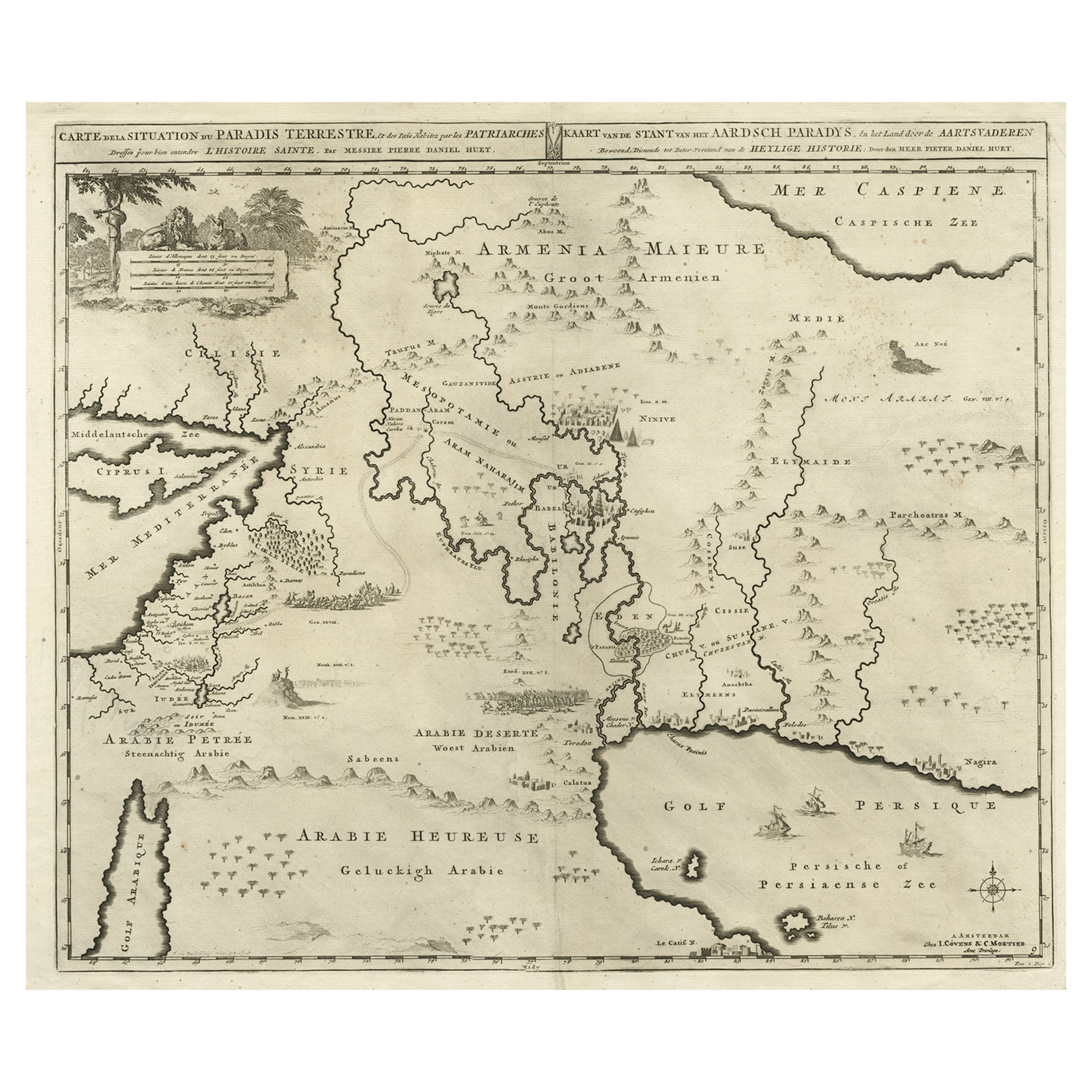
View AllBiblical Map of the Region from the Mediterranean through the Persian Gulf, 1720
Located in Langweer, NL
Antique map titled 'Carte de la Situation du Paradis Terrestre, Et des Pais Habitez par les Patriarches Dressee pour bien entendre l'Histoire Sainte, Par Messire Pierre Daniel Huet.'
This interesting map covers the region from the Mediterranean through the Persian Gulf. Detail is omitted in favor of Biblical depictions including the Sermon on the Mount...
Category
Antique 1720s Maps
Materials
Paper
$459 Sale Price
20% Off
Antique Map of the Holy Land Described in the Old and New Testament, ca.1660
Located in Langweer, NL
Antique map titled 'Geographiae Sacrae ex Veteri et Novo Testamento Desumptae Tabula Prima quae Totius Orbis Partes Continet.'
Map of the lands described in the Old and New Testame...
Category
Antique 1660s Maps
Materials
Paper

$813 Sale Price
20% Off
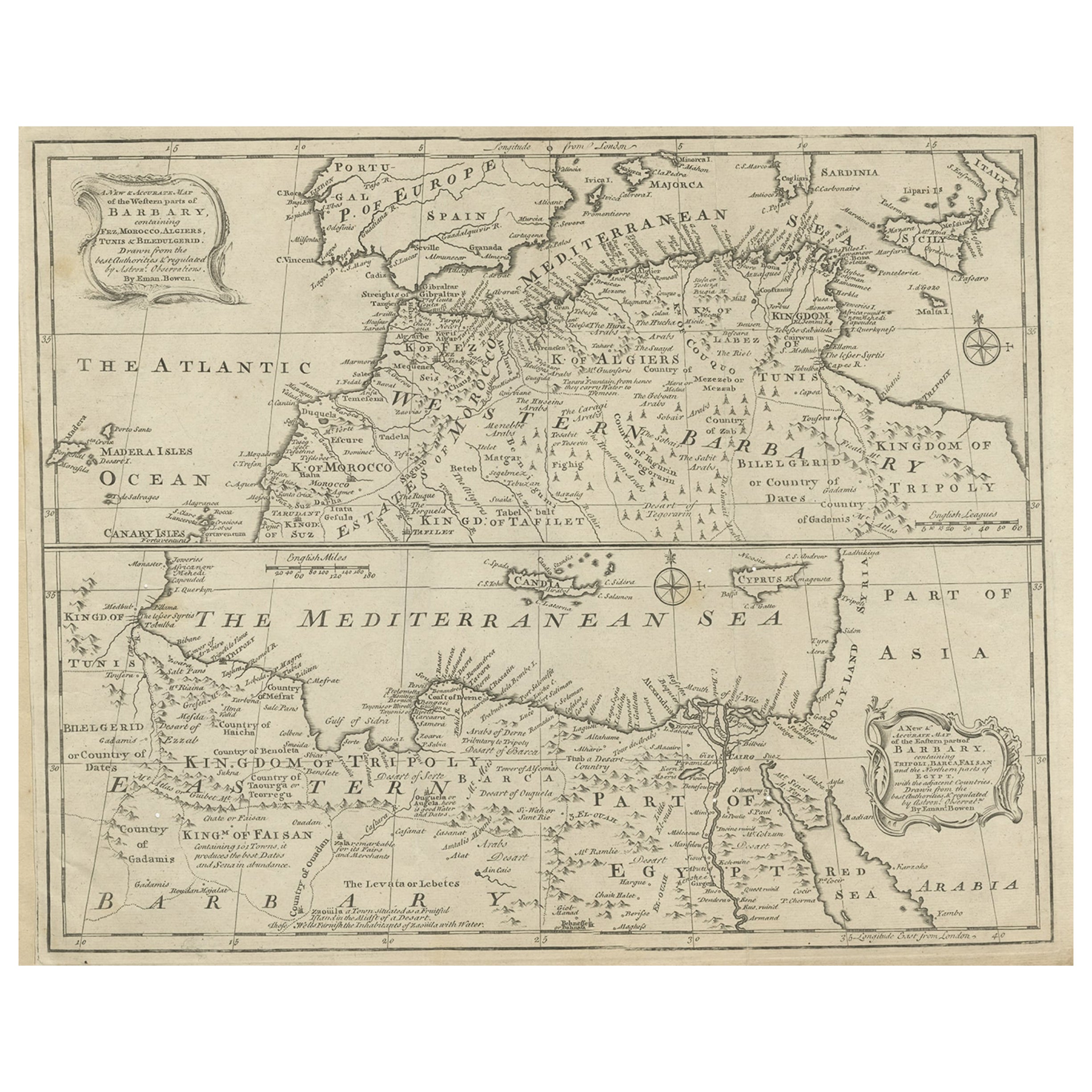
Antique Map of Western and Eastern Barbary in Africa, c.1744
Located in Langweer, NL
Antique map titled 'A New & Accurate Map of the Western Parts of Barbary' and 'A New & Accurate Map of the Eastern Parts of Barbary'. Decorative maps of North Africa and the Southern...
Category
Antique 18th Century Maps
Materials
Paper
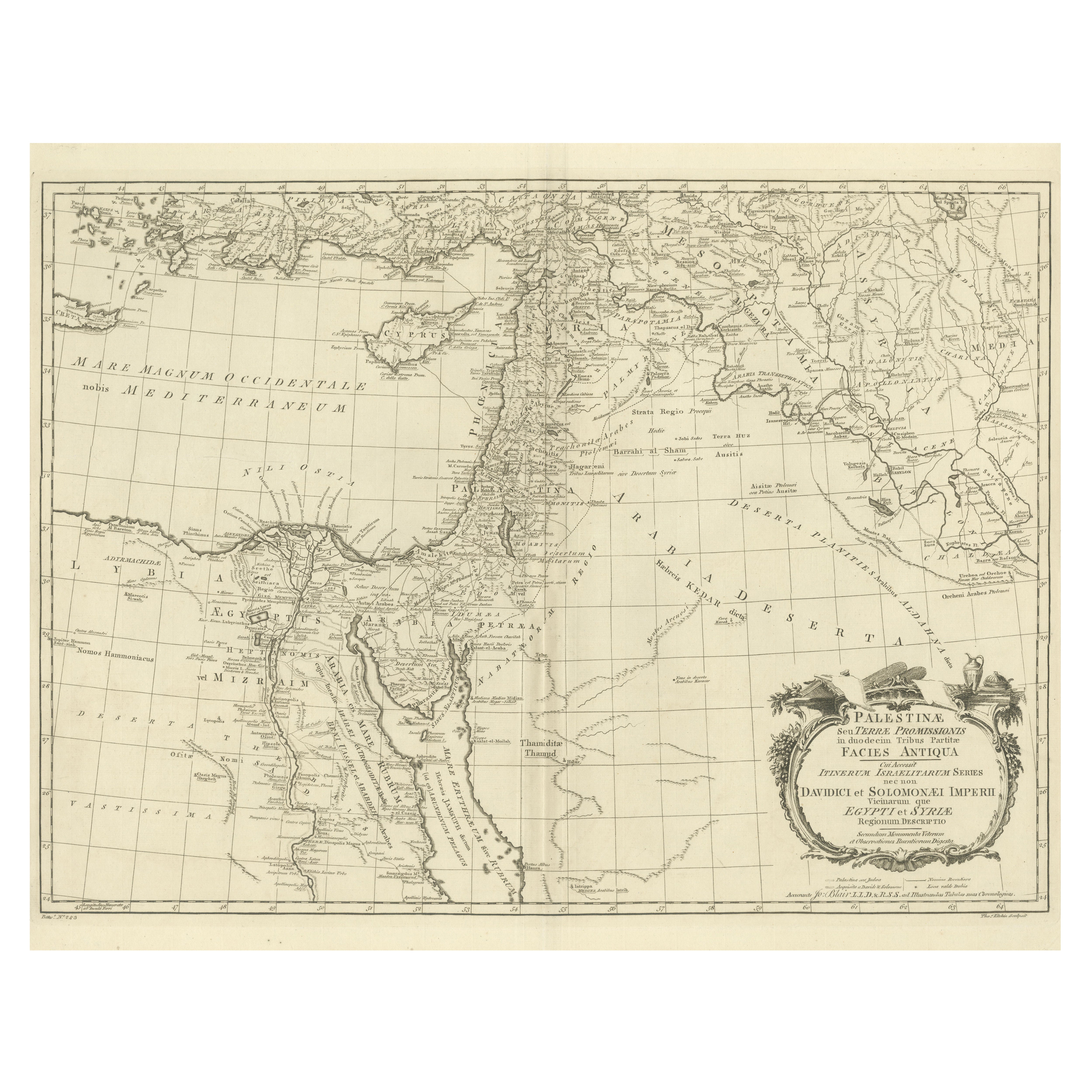
1773 John Blair Map of the Ancient Holy Land: Tribes, Journeys, and Empires
Located in Langweer, NL
Title: 1773 John Blair Map of the Ancient Holy Land: Tribes, Journeys, and Empires
This exceptional map by John Blair, published in London in 1773, offers a richly detailed view o...
Category
Antique 1770s English Maps
Materials
Paper
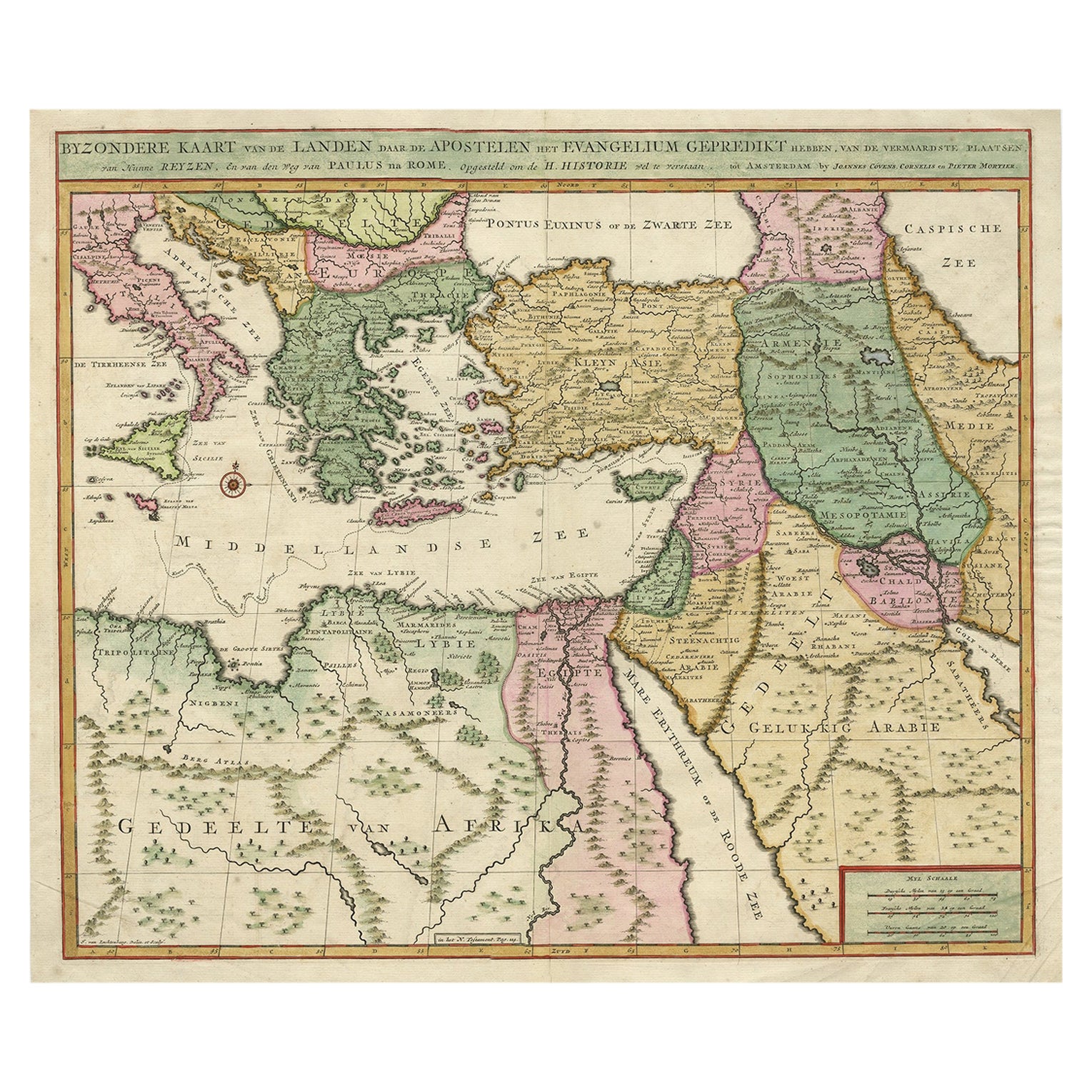
Highly Decorative Map of The Eastern Mediterranean and The Middle East, ca.1700
Located in Langweer, NL
Antique map titled 'Byzondere Kaart van de Landen Daar de Apostelen Het Evangelium Gepredikt Hebben (..).'
Highly decorative map of the eastern Mediterranean...
Category
Antique Early 1700s Maps
Materials
Paper
$908 Sale Price
20% Off
Free Shipping
1700 Guillaume Delisle Map: Western Mediterranean & Moorish North Africa
Located in Langweer, NL
1700 Guillaume Delisle Map: Western Mediterranean & Moorish North Africa
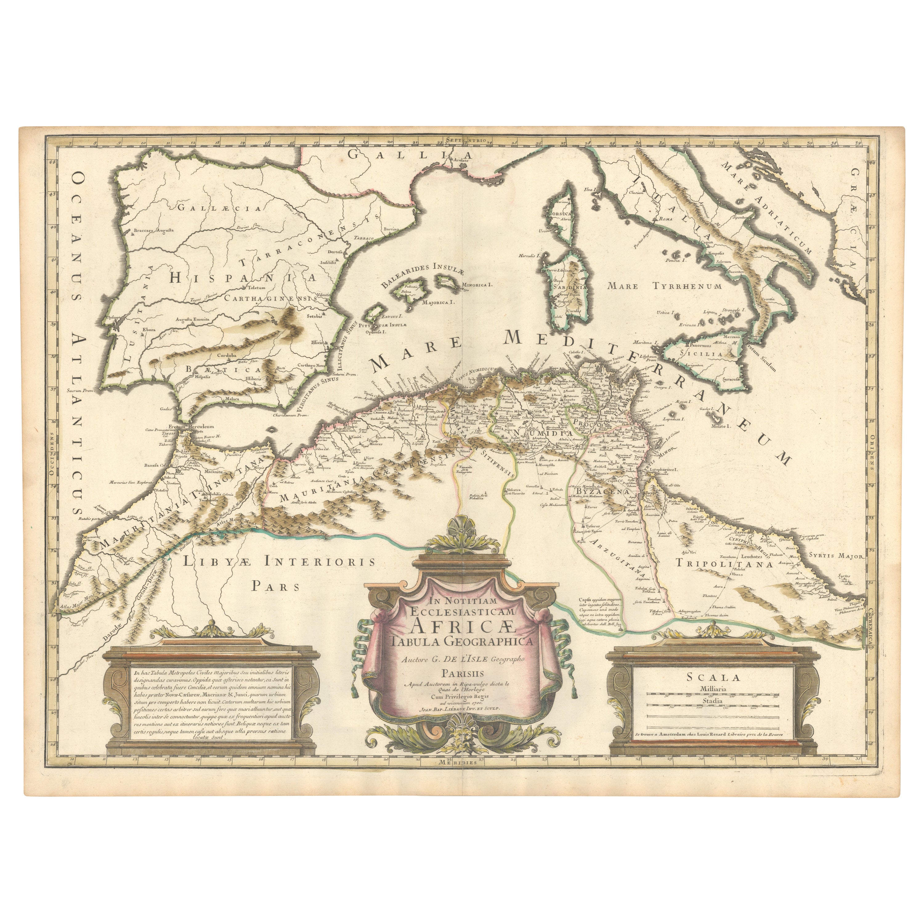
This hand-colored map from 1700 by Guillaume Delisle, titled "In Notitiam Ecclesiasticam Africae Tabula Geographica," offers a detailed look at the regions under Moorish control during the later medieval period.
It encompasses the northern African coast from Morocco to Libya, the Iberian Peninsula, and the western Mediterranean, including notable islands such as Sardinia, Corsica, Malta, the Balearics, and Sicily, where a smoking Mount Etna is depicted.
The map is embellished with three decorative cartouches, adding artistic flair to the detailed geographical renderings.
Engraved by Jean Baptiste Liebaux, the map measures 25.2 inches wide by 19.1 inches high.
It features a sharp impression with contemporary outline color, later enhanced cartouches, and is printed on a bright sheet with a Society of Jesus watermark.
The condition is very good, with an archivally repaired centerfold separation at the bottom and light toning along the edges.
Keywords:
- Guillaume Delisle map
- Western Mediterranean historical map
- Northern Africa map...
Category
Antique Early 1700s Maps
Materials
Paper
$870 Sale Price
20% Off
You May Also Like
Map Holy Land La Terre Sainte Engraved van Loon Published N de Fer 1703 French
Located in BUNGAY, SUFFOLK
La Terre Sainte, The Holy Land, Tiree Des Memoires De M.De.La Rue. Par N. de Fer. Geographe de Sa Majeste Catoliq et de Monseigneur le Dauphin. Avec Privil du Roi 1703
Detailed map of the Holy Land from Nicholas de Fer's L'Atlas Curieux ou le Monde. East is oriented at the top.
MAKER Nicolas de Fer 1646-1720
The French cartographer and engraver, Nicolas de Fer, was a master at creating maps that were works of art. The maps that he published were printed during the Baroque period when the decorative arts were characterized by ornate detail. De Fer’s detailed maps and atlases were valued more for their decorative content than their geographical accuracy.
Nicolas de Fer was born in 1646. His father, Antoine de Fer, owned a mapmaking firm. At the age of twelve, Nicolas was apprenticed to a Parisian engraver named Louis Spirinx. The family business was starting to decline when his father died in 1673. Nicolas de Fer’s mother, Genevieve, took over the business after the death of her husband. In 1687 the business was passed on to Nicolas and the profits increased after he took over the firm. Nicolas de Fer was a prolific cartographer who produced atlases and hundreds of single maps. He eventually became the official geographer to King Louis XIV of France and King Philip V...
Category
Antique Early 1700s French Louis XIV Maps
Materials
Paper

London 1744 Published Watercolour Antique Map of East Africa by Eman Bowen
Located in West Sussex, Pulborough
We are delighted to offer for sale this New and Accurate Map of Nubia & Abissinia, together with all the Kingdoms Tributary Thereto, and bordering upon them published in 1744 by Emanuel Bowen
This is a decorative antique engraved map of East Africa...
Category
Antique 1740s English George III Maps
Materials
Paper

$916 Sale Price
30% Off
1718 Ides & Witsen Map "Route D'amsterdam a Moscow Et De La Ispahan Et Gamron
Located in Norton, MA
1718 Ides & Witsen map, entitled
"Route D'Amsterdam A Moscow Et De La Ispahan Et Gamron,"
Ric.b005
Subject: Eastern Europe and Central Asia
Period: 1718 (published)
Publicati...
Category
Antique Early 18th Century Dutch Maps
Materials
Paper

1633 Map "La Souverainete De Sedan Et De Raucourt, Et La Prevoste Ric0011
Located in Norton, MA
1653 map entitled
"La Souverainete de Sedan et de Raucourt, et la Prevoste de Doncheri,"
Ric0011
Description:
Lovely map centered on Sedan and Doncheri and the Meuze River fr...
Category
Antique 17th Century Dutch Maps
Materials
Paper

Original Antique Map of Africa by Dower, circa 1835
Located in St Annes, Lancashire
Nice map of Africa
Drawn and engraved by J.Dower
Published by Orr & Smith. C.1835
Unframed.
Free shipping
Category
Antique 1830s English Maps
Materials
Paper

Africa: A Large 17th Century Hand-colored Map By Sanson and Jaillot
By Nicholas Sanson d'Abbeville
Located in Alamo, CA
This large original hand-colored copperplate engraved map of Africa entitled "L'Afrique divisee suivant l'estendue de ses principales parties ou sont distingues les uns des autres, L...
Category
1690s Landscape Prints
Materials
Engraving

More Ways To Browse
Middle East Furniture
North Africa Map
Carthage Antique
Queen Of Sheba
Pedestal Mahogany Dining Table
Round Table Base
Metal Coffee Table 1970s
Italian Lacquer Dining Room Sets
Paisley Rugs and Carpets
Vintage Scandinavian Armchairs
1970 Italian Armchair
Antique Cow
Chrome Glass Coffee Tables
Environment Furniture
China Silk Rug
Early English Silver
Antique Walnut Bar
Ceramic 1960s Italy