Items Similar to Antique Bird's-Eye Plan of Tutecoryn (Tuticorin or Thoothukudi), India, 1672
Want more images or videos?
Request additional images or videos from the seller
1 of 7
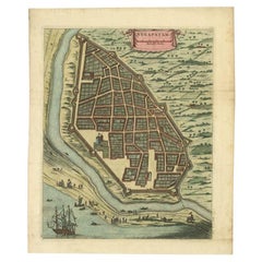
Antique Bird's-Eye Plan of Tutecoryn (Tuticorin or Thoothukudi), India, 1672
$344.18
$430.2320% Off
£254.80
£318.5020% Off
€288
€36020% Off
CA$476.26
CA$595.3320% Off
A$524.99
A$656.2420% Off
CHF 274.70
CHF 343.3820% Off
MX$6,441.47
MX$8,051.8420% Off
NOK 3,457.93
NOK 4,322.4120% Off
SEK 3,233.71
SEK 4,042.1420% Off
DKK 2,192.83
DKK 2,741.0420% Off
About the Item
Antique map, titled: 'Tutecoryn.'
Bird's-eye plan of map of Tutecoryn (Tuticorin or Thoothukudi), India. This map originates from 'Naauwkeurige Beschryvinge van Malabar en Choromandel…en het machtige Eyland Ceylon' by Philippus Baldaeus.
Artists and Engravers: Made by 'Philip Baldaeus' after an anonymous artist. Philip Baldaeus (1632-1672). Father Philippus Baldaeus, Baelde or Philip Balde (October 1632, Delft - 1672, Geervliet) was a Dutch minister. He went to Jaffna, Ceylon with an invading Dutch force during 17th Century. As the first European he documented the life, language and culture of Tamil people, living in the north of the island. It is a great historical record, similar to Mahawamsa, and it was immediately published in Dutch and German (with many beautiful plates).
Condition:
Good, given age. Edges browned and an occasional tiny tear. A few minor creases. Original middle fold as issued. General age-related toning and/or occasional minor defects from handling. Please study scan carefully.
- Dimensions:Height: 12.01 in (30.5 cm)Width: 14.77 in (37.5 cm)Depth: 0 in (0.02 mm)
- Materials and Techniques:Paper,Engraved
- Period:1670-1679
- Date of Manufacture:1672
- Condition:Wear consistent with age and use. Good, given age. Edges browned and an occasional tiny tear. A few minor creases. Original middle fold as issued. General age-related toning and/or occasional minor defects from handling. Please study scan carefully.
- Seller Location:Langweer, NL
- Reference Number:Seller: PCT-614161stDibs: LU3054326686402
About the Seller
5.0
Recognized Seller
These prestigious sellers are industry leaders and represent the highest echelon for item quality and design.
Platinum Seller
Premium sellers with a 4.7+ rating and 24-hour response times
Established in 2009
1stDibs seller since 2017
2,615 sales on 1stDibs
Typical response time: <1 hour
- ShippingRetrieving quote...Shipping from: Langweer, Netherlands
- Return Policy
Authenticity Guarantee
In the unlikely event there’s an issue with an item’s authenticity, contact us within 1 year for a full refund. DetailsMoney-Back Guarantee
If your item is not as described, is damaged in transit, or does not arrive, contact us within 7 days for a full refund. Details24-Hour Cancellation
You have a 24-hour grace period in which to reconsider your purchase, with no questions asked.Vetted Professional Sellers
Our world-class sellers must adhere to strict standards for service and quality, maintaining the integrity of our listings.Price-Match Guarantee
If you find that a seller listed the same item for a lower price elsewhere, we’ll match it.Trusted Global Delivery
Our best-in-class carrier network provides specialized shipping options worldwide, including custom delivery.More From This Seller
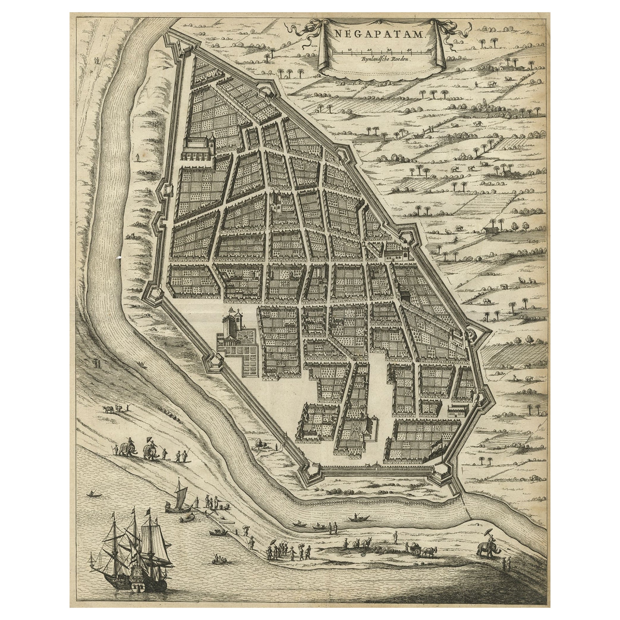
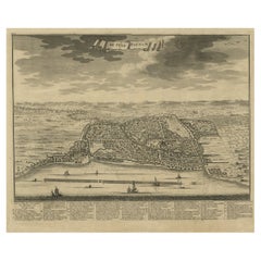
View AllAntique Engraving of a Bird's-Eye Plan of Nagapattinam or Negapatam, India, 1672
Located in Langweer, NL
Antique map titled 'Negapatam.'
Bird's-eye plan of Nagapattinam or Negapatam, India. This map originates from 'Naauwkeurige Beschryvinge van Malabar en Choromandel…en het machtige ...
Category
Antique 1670s Maps
Materials
Paper
$325 Sale Price
20% Off
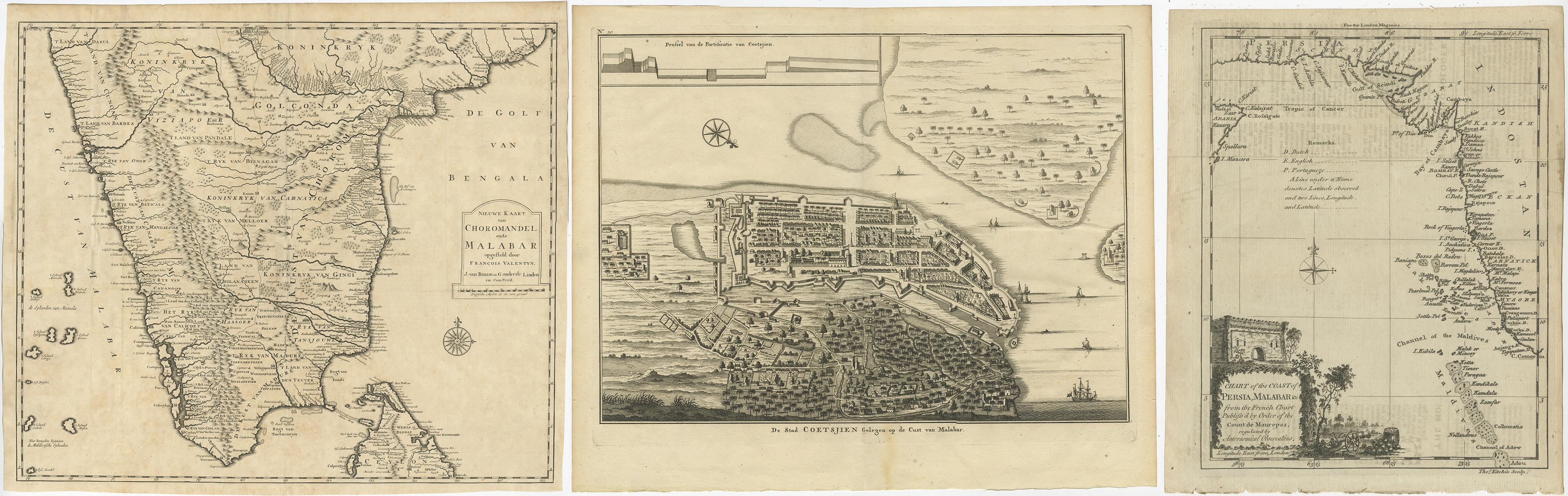
Antique Maps of the Malabar Coast – Valentyn, Cochin, and Malabar, 17
Located in Langweer, NL
Antique Maps of the Malabar Coast – Valentyn, Cochin, and London Magazine, 17th–18th Century
Description:
This compilation of three antique maps and views offers a remarkable cross-...
Category
Antique 19th Century Maps
Materials
Paper
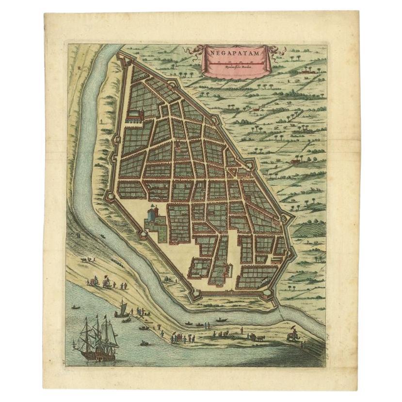
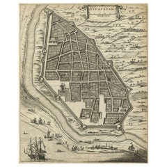
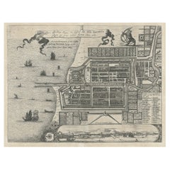
Attractive Hand-Colored Antique Plan of Nagapattinam in India, 1744
Located in Langweer, NL
Antique map titled 'Negapatam.' Attractive bird's-eye view of Nagapattinam, India from Churchill's 'A Collection of Voyages and Travels, some now first printed from original manuscri...
Category
Antique 18th Century Maps
Materials
Paper
$528 Sale Price
25% Off
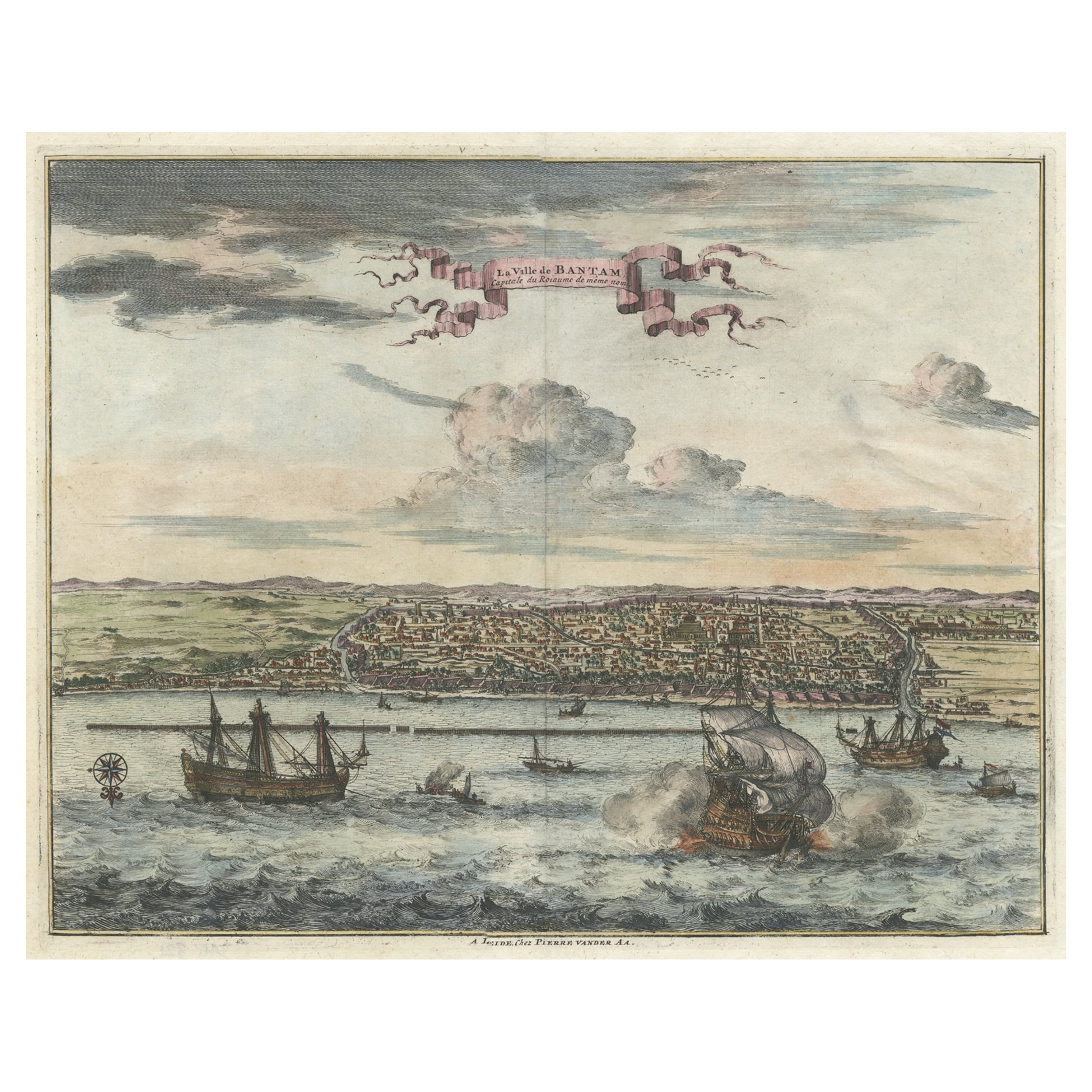
Original Antique Bird's Eye View of Banten or Bantam in Java, Indonesia, 1725
Located in Langweer, NL
Antique print titled 'La Ville de Bantam capitale du Roiaume de meme nom'.
A bird's eye view of the city Banten or Bantam near the western end of Java in Indonesia. Several tall ...
Category
Antique 1720s Prints
Materials
Paper

$688 Sale Price
20% Off
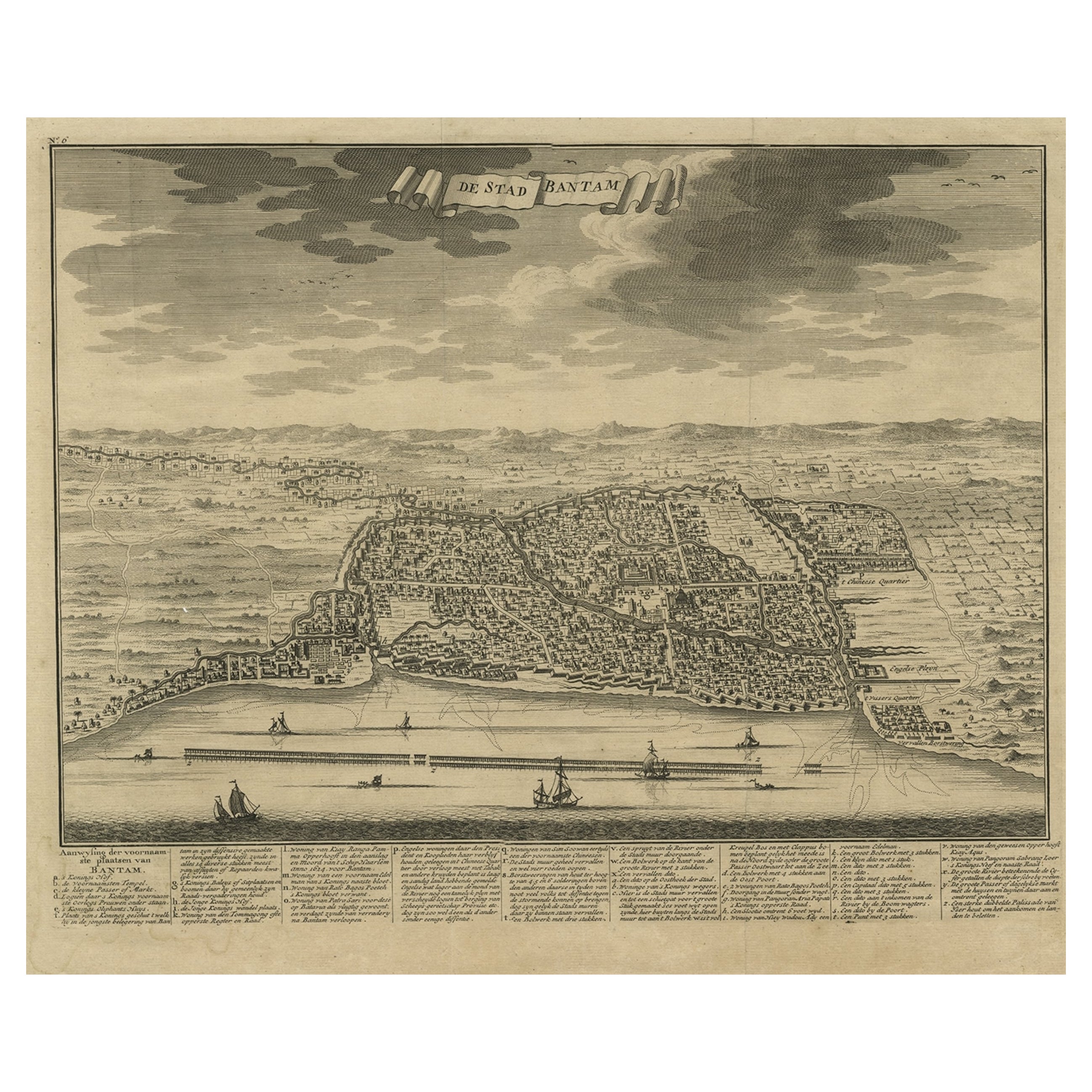
Decorative View of the Indonesian Town of Bantam 'Banten', Java, 1726
Located in Langweer, NL
Decorative town-view of the town of Bantam (Banten). In lower margin key a-z to the principal places in town.
The Banten Sultanate was founded in the 16th century and centred in ...
Category
Antique 1720s Maps
Materials
Paper
$535 Sale Price
20% Off
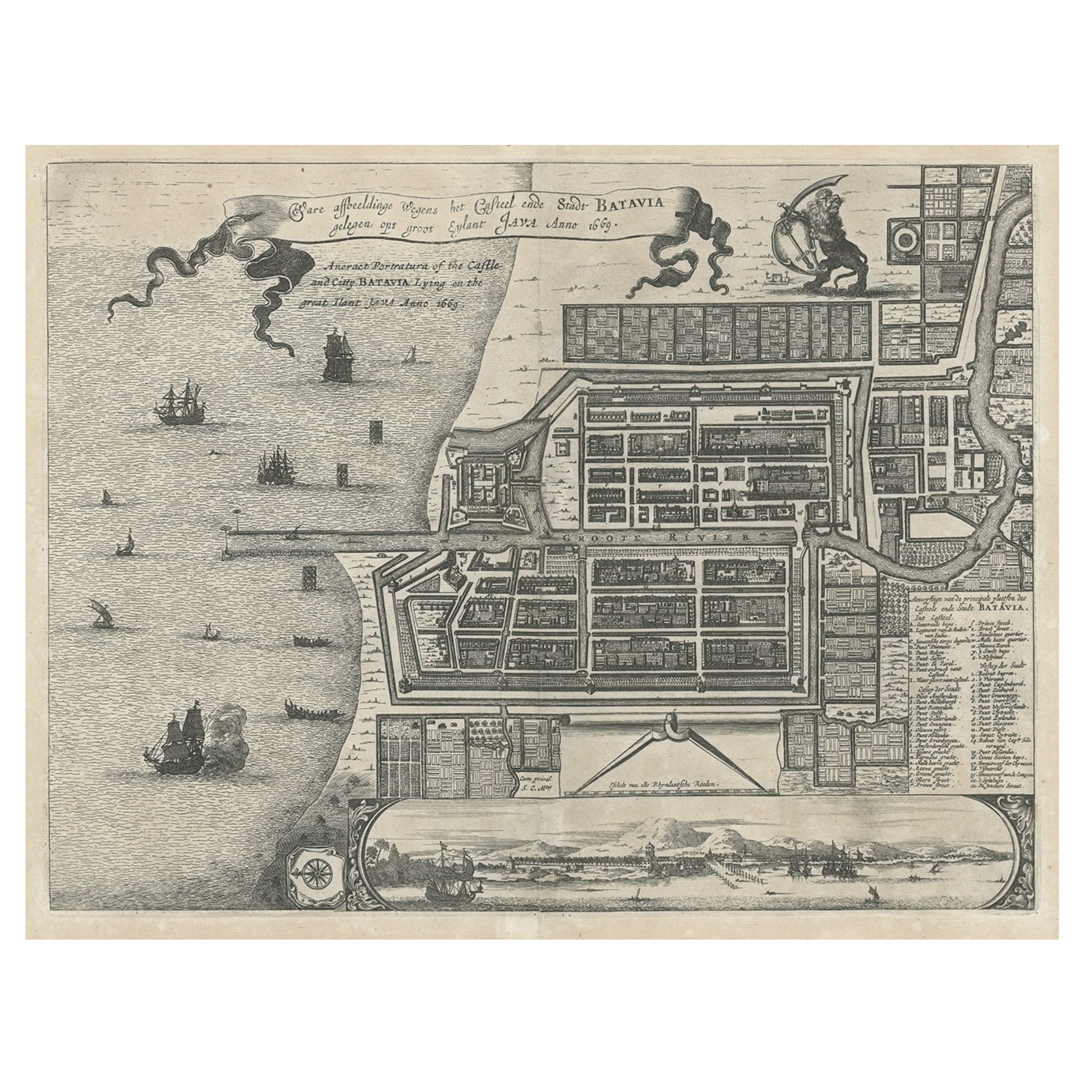
Antique Plan of the Castle & City of Batavia 'Jakarta' on Java, Indonesia, c1669
Located in Langweer, NL
Antique map Batavia titled 'Ware Affbeeldinge wegens het Casteel ende Stadt Batavia'.
Antique print of the castle and city of Batavia on the Island of Java'. Rare edition with En...
Category
Antique 1660s Maps
Materials
Paper
$1,195 Sale Price
20% Off
You May Also Like
1597 German Map of Alexandria by Georg Braun and Frans Hogenberg
By Georg Braun and Frans Hogenberg
Located in Chapel Hill, NC
1597 Map of Alexandria by Georg Braun and Frans Hogenberg, Germany. From "Civitas Orbis Terrarum", part 2, published in Cologne by Bertram Buchholz. Printed in 2 parts. Title: "Alexa...
Category
Antique 16th Century German Renaissance Maps
Materials
Paper

1646 Jansson Map Entitled "Procinvia Connactiae, " Ric.a006
Located in Norton, MA
1646 Jansson map entitled
"Procinvia connactiae,"
Ric.a006
Description: The PROVINCE of CONNAVGT 490 x 380From vol 4 of Jansson's Atlas Novus 1646, published in Amsterdam with...
Category
Antique 17th Century Unknown Maps
Materials
Paper

17th Century Toulouse, Savve, Sommieres Topographical Map by Iohan Peeters
Located in New York, NY
Fine topographical 17th century map of Toulouse, Savve and Sommieres by Iohan Peeters
Beautiful engraving of the capital of France's Occitanie Region, Toulouse, called La Ville Rose- the Pink City, for the terracotta bricks used in its many buildings, giving the city a distinct apricot-rose hue. An important cultural and educational center, the city's residents included Nobel Prize winners and world renown artists- Henri de Toulouse-Lautrec, Henri Martin, Jean-Auguste-Dominique Ingres, Antonin Mercie, Alexandre Falguiere and more recently Cyril Kongo...
Category
Antique 17th Century Dutch Maps
Materials
Paper

1633 Map "La Souverainete De Sedan Et De Raucourt, Et La Prevoste Ric0011
Located in Norton, MA
1653 map entitled
"La Souverainete de Sedan et de Raucourt, et la Prevoste de Doncheri,"
Ric0011
Description:
Lovely map centered on Sedan and Doncheri and the Meuze River fr...
Category
Antique 17th Century Dutch Maps
Materials
Paper

Antique Voc Print Holland Malaysia Old Map Melaka History, 1663
Located in Amsterdam, Noord Holland
From my own collection I offer this impressive Antique print of the city of Malakka
A very interesting piece for collectors . It is an museum piece from the Dutch Institute of Orien...
Category
Antique 17th Century European Paintings
Materials
Paper

$293 Sale Price
20% Off
17th-18th Century Siege of Graves Mapping Engraving By Willian III
Located in Kingston, NY
RARE French 17th-18th Century Enhanced Siege of Graves Mapping Engraving BY William III, also widely known as William of Orange,
The Siege of Grave in Dutch Brabant started by Monsie...
Category
Antique 17th Century French Prints
Materials
Paper

More Ways To Browse
Philip North
Philippines Map
Sebastian Munster
South African Antique
Antique Sri Lanka Map
L Tardieu
Map Of Palestine
Otto Petri
Antique Map Of Jerusalem
Iraq Map
Antique Map Of Korea
Solomons Temple
Antique Maps Caribbean Islands
Antique Wine Maps
Map Of Jamaica
Used Furniture Wisconsin
Antique Furniture Michigan
Antique Maps Of Cape Of Good Hope