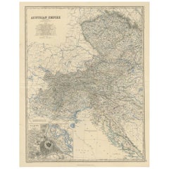
Antique Map of the Austrian Empire ‘West’ by A.K. Johnston, 1865
View Similar Items


Want more images or videos?
Request additional images or videos from the seller
1 of 5
Antique Map of the Austrian Empire ‘West’ by A.K. Johnston, 1865
About the Item
- Dimensions:Height: 24.41 in (62 cm)Width: 19.1 in (48.5 cm)Depth: 0.02 in (0.5 mm)
- Materials and Techniques:
- Period:
- Date of Manufacture:1865
- Condition:General age-related toning. Please study image carefully.
- Seller Location:Langweer, NL
- Reference Number:Seller: BG-05553/201stDibs: LU3054310726733
About the Seller
5.0
Platinum Seller
These expertly vetted sellers are 1stDibs' most experienced sellers and are rated highest by our customers.
Established in 2009
1stDibs seller since 2017
1,933 sales on 1stDibs
More From This SellerView All
- Antique Map of South-West Russia by A.K. Johnston, 1865Located in Langweer, NLAntique map titled 'South-West Russia showing the extent of the Kingdom of Poland previous to its partition in 1772'. This map originates from the ‘Royal Atlas of Modern Geography’ b...Category
Antique Mid-19th Century Maps
MaterialsPaper

- Antique Map of Denmark by A.K. Johnston, 1865Located in Langweer, NLAntique map titled 'Denmark and the Duchies Schleswig, Holstein & Lauenburg; Hanover, Brunswick, Mecklenburg, Oldenburg, Anhalt and Lippe'. With an inset map of Iceland, Copenhagen a...Category
Antique Mid-19th Century Maps
MaterialsPaper
- Antique Map of Sweden & Norway by A.K. Johnston '1865'Located in Langweer, NLAntique map titled 'Sweden & Norway (Scandinavia)'. With an inset map of Stockholm and environments. This map originates from the ‘Royal Atlas of Modern Geography’ by Alexander Keith...Category
Antique Mid-19th Century Maps
MaterialsPaper
 $219 Sale Price27% Off
 - Antique Map of South Australia by A.K. Johnston, 1865Located in Langweer, NLAntique map titled 'South Australia, New South Wales, Victoria & Queensland'. This map originates from the ‘Royal Atlas of Modern Geography’ by Alexander Keith Johnston. Published by...Category
Antique Mid-19th Century Maps
MaterialsPaper
 $263 Sale Price20% Off
 - Antique Map of Scotland 'South' by A.K. Johnston, 1865Located in Langweer, NLAntique map titled 'Scotland (Southern Sheet)'. This map originates from the ‘Royal Atlas of Modern Geography’ by Alexander Keith Johnston. Published by William Blackwood and Sons, E...Category
Antique Mid-19th Century Maps
MaterialsPaper
 $219 Sale Price27% Off
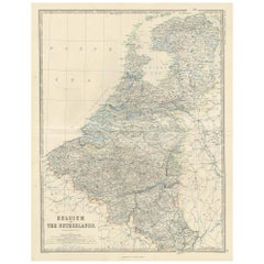
 - Antique Map of Belgium and The Netherlands by A.K. Johnston, 1865Located in Langweer, NLAntique map titled 'Belgium and The Netherlands'. This map originates from the ‘Royal Atlas of Modern Geography’ by Alexander Keith Johnston. Published by William Blackwood and Sons,...Category
Antique Mid-19th Century Maps
MaterialsPaper

You May Also Like
- Germany West of the Rhine: A Hand-colored 18th Century Map by de WitBy Frederick de WitLocated in Alamo, CAThis original 18th century hand-colored map of the county of Moers, Germany entitled "Illustrissimo Celsissmo Principi GUILIELMO HENRICO D.G. Arausionum Principi Domino suo Clementis...Category
Antique Early 18th Century Dutch Maps
MaterialsPaper
- Original Antique English County Map - West Yorkshire. J & C Walker. 1851Located in St Annes, LancashireGreat map of The West Riding of Yorkshire Original colour By J & C Walker Published by Longman, Rees, Orme, Brown & Co. 1851 Unframed.Category
Antique 1850s English Other Maps
MaterialsPaper
- Original Antique Map of The World by Thomas Clerk, 1817Located in St Annes, LancashireGreat map of The Eastern and Western Hemispheres On 2 sheets Copper-plate engraving Drawn and engraved by Thomas Clerk, Edinburgh. Published by Mackenzie And Dent, 1817 ...Category
Antique 1810s English Maps
MaterialsPaper
- 17th Century Hand-Colored Map of West Africa by Mercator/HondiusLocated in Alamo, CAA 17th century hand-colored map entitled "Guineae Nova Descriptio" by Gerard Mercator and Jodocus Hondius, published in their 'Atlas Minor' in Amsterdam in 1635. It is focused on the...Category
Antique Mid-17th Century Dutch Maps
MaterialsPaper
- Map of the Republic of GenoaLocated in New York, NYFramed antique hand-coloured map of the Republic of Genoa including the duchies of Mantua, Modena, and Parma. Europe, late 18th century. Dimension: 25...Category
Antique Late 18th Century European Maps
- Antique Map of Principality of MonacoBy Antonio Vallardi EditoreLocated in Alessandria, PiemonteST/619 - "Old Geographical Atlas of Italy - Topographic map of ex-Principality of Monaco" - ediz Vallardi - Milano - A somewhat special edition ---Category
Antique Late 19th Century Italian Other Prints
MaterialsPaper
 $228 Sale Price74% Off


Recently Viewed
View AllMore Ways To Browse
Antique Wien
Antique Map Of Austria
Croatia Antique Map
Map Austrian Empire
Bohemia Map
Croatia Map
Antique Whimsical
Antique Atlas Map
Antique Prints Maps
Antique Maps Prints
Antique Map Prints
Antique Map Print
Antique Maps And Prints
Antique Prints And Maps
Map 19th Century
Antique Atlas Furniture
Antique Lined Paper
Map Of France