Items Similar to Antique Map of British Guayana with Insets of Georgetown, Devil's Rock Etc, 1851


Want more images or videos?
Request additional images or videos from the seller
1 of 5
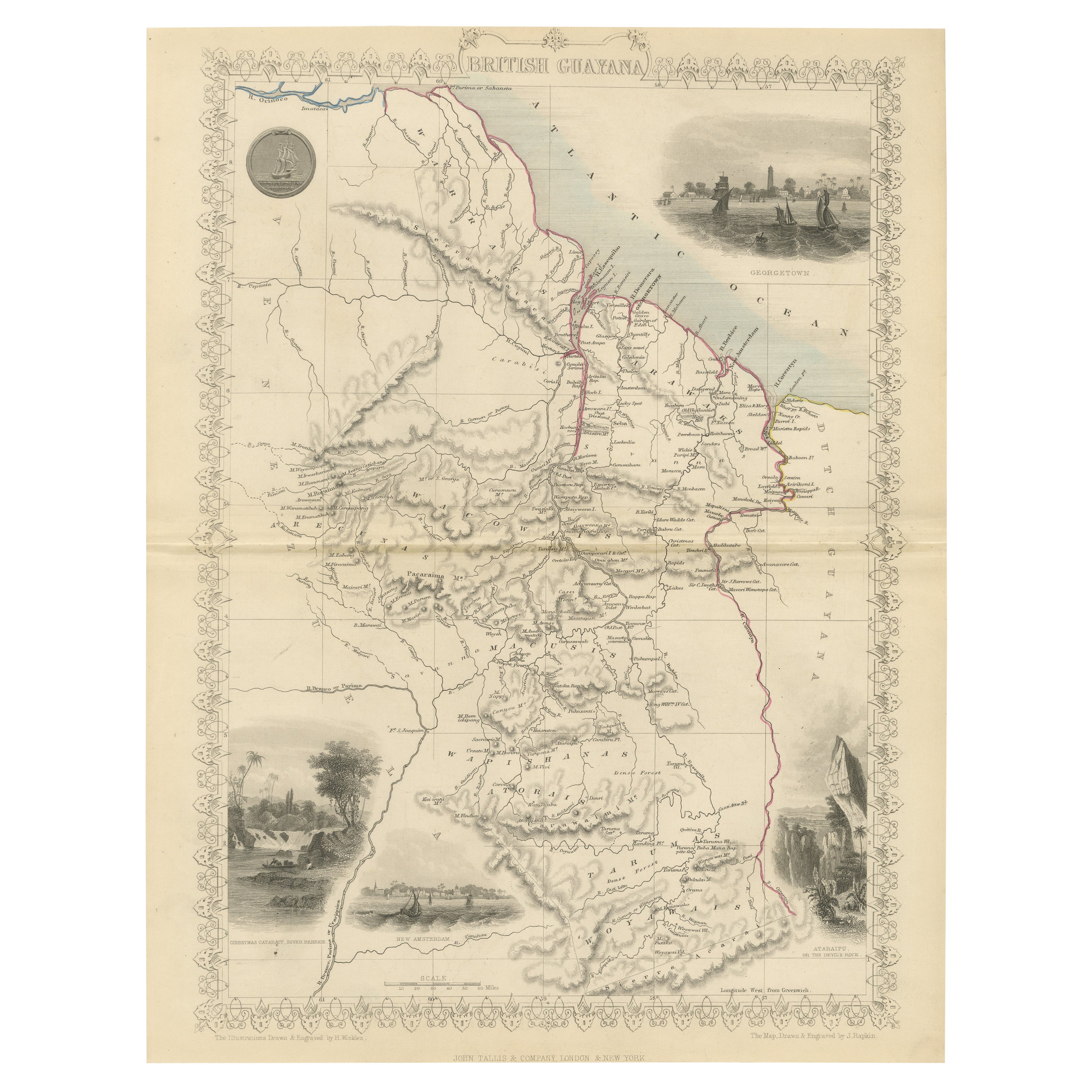
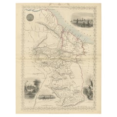
Antique Map of British Guayana with Insets of Georgetown, Devil's Rock Etc, 1851
$428.57
$535.7220% Off
£318.55
£398.1820% Off
€360
€45020% Off
CA$591.74
CA$739.6820% Off
A$656.20
A$820.2520% Off
CHF 344.78
CHF 430.9820% Off
MX$8,017.63
MX$10,022.0320% Off
NOK 4,313.71
NOK 5,392.1420% Off
SEK 4,049.16
SEK 5,061.4420% Off
DKK 2,741.22
DKK 3,426.5220% Off
About the Item
Antique map titled ‘British Guayana’. Includes decorative vignettes titled Georgetown, Christmas Cataract River Berbice, New Amsterdam and Ataraipu or the Devil’s Rock. Originates from 'The Illustrated Atlas, And Modern History Of The World Geographical, Political, Commercial & Statistical, Edited By R. Montgomery Martin'. Published; John Tallis London, New York, Edinburgh & Dublin. 1851. Drawn and Engraved by J. Rapkin.
Artists and Engravers: John Tallis (1817-1876) was a British map publisher. Born in the Midlands, Tallis came to London in the 1840s. Tallis began his London career with a series of remarkable London street views. He began a partnership with a Frederick Tallis, possibly his brother, but their collaboration ended in 1849. For the Great Exhibition of 1851, Tallis published the Illustrated World Atlas, one of the last series of decorative world maps ever produced. The maps were engraved by John Rapkin, a skilled artisan. The maps were later reissued by the London Printing & Publishing Company, who left the Tallis imprint intact, thus ensuring his enduring fame. In 1858, he began publication of the popular Illustrated News of the World and National Portrait Gallery of Eminent Personages, selling it in 1861 (it ceased publication in 1863).
We sell original antique maps to collectors, historians, educators and interior decorators all over the world. Our collection includes a wide range of authentic antique maps from the 16th to the 20th centuries. Buying and collecting antique maps is a tradition that goes back hundreds of years. Antique maps have proved a richly rewarding investment over the past decade, thanks to a growing appreciation of their unique historical appeal. Today the decorative qualities of antique maps are widely recognized by interior designers who appreciate their beauty and design flexibility. Depending on the individual map, presentation, and context, a rare or antique map can be modern, traditional, abstract, figurative, serious or whimsical. We offer a wide range of authentic antique maps for any budget.
- Dimensions:Height: 14.18 in (36 cm)Width: 10.83 in (27.5 cm)Depth: 0 in (0.01 mm)
- Materials and Techniques:
- Period:
- Date of Manufacture:1851
- Condition:Condition: Good. General age-related toning. Original fold as published, small tears along the folding line and page border. Please study image carefully.
- Seller Location:Langweer, NL
- Reference Number:Seller: BG-034451stDibs: LU3054326084122
About the Seller
5.0
Recognized Seller
These prestigious sellers are industry leaders and represent the highest echelon for item quality and design.
Platinum Seller
Premium sellers with a 4.7+ rating and 24-hour response times
Established in 2009
1stDibs seller since 2017
2,609 sales on 1stDibs
Typical response time: <1 hour
- ShippingRetrieving quote...Shipping from: Langweer, Netherlands
- Return Policy
Authenticity Guarantee
In the unlikely event there’s an issue with an item’s authenticity, contact us within 1 year for a full refund. DetailsMoney-Back Guarantee
If your item is not as described, is damaged in transit, or does not arrive, contact us within 7 days for a full refund. Details24-Hour Cancellation
You have a 24-hour grace period in which to reconsider your purchase, with no questions asked.Vetted Professional Sellers
Our world-class sellers must adhere to strict standards for service and quality, maintaining the integrity of our listings.Price-Match Guarantee
If you find that a seller listed the same item for a lower price elsewhere, we’ll match it.Trusted Global Delivery
Our best-in-class carrier network provides specialized shipping options worldwide, including custom delivery.More From This Seller
View AllA Tallis Map of British Guiana with Colonial Vignettes and Other Landmarks, 1851
Located in Langweer, NL
This Tallis map of British Guiana (now known as Guyana) is a richly decorated document, much like other maps from the esteemed cartographic publisher John Tallis & Company. The firm,...
Category
Antique 1850s Maps
Materials
Paper
$276 Sale Price
20% Off
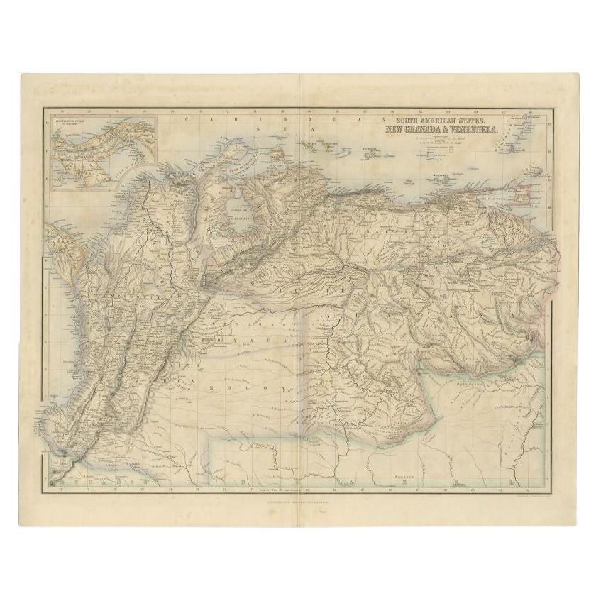
Antique Map of the Northern Part of South America by Fullarton, 1855
Located in Langweer, NL
Antique map titled 'South American States, New Granada & Venezuela'. Detailed map of the northern part of South America. With a small inset map of Panama. Originates from the 'Royal ...
Category
Antique 19th Century Maps
Materials
Paper
$123 Sale Price
20% Off
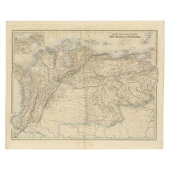
Antique Map of the Northern Part of South America by J. Tallis, circa 1851
Located in Langweer, NL
A decorative and detailed mid-19th century map of the northern part of South America (including modern day Venezuela, Colombia, Ecuador, Guyana, Suriname and French Guiana) which was drawn and engraved by J. Rapkin (vignettes by H. Winkles & W. Lacey) and published in John Tallis & Co.'s The Illustrated Atlas (London & New York: circa 1851).
The Illustrated Atlas, published from 1849 onwards, was the last decorative world atlas. The 'Venezuela, New Granada...' map was typical of the many Fine ones which appeared in this work with its decorative border and attractive vignettes. Illustrated are views of Mount Chimborazo, Ecuador; the 'Fall of the Bagota' (Tequendama Falls, Colombia); Rheas and a prospect of Paramaribo Harbour (Dutch Guiana...
Category
Antique Mid-19th Century English Maps
Materials
Paper

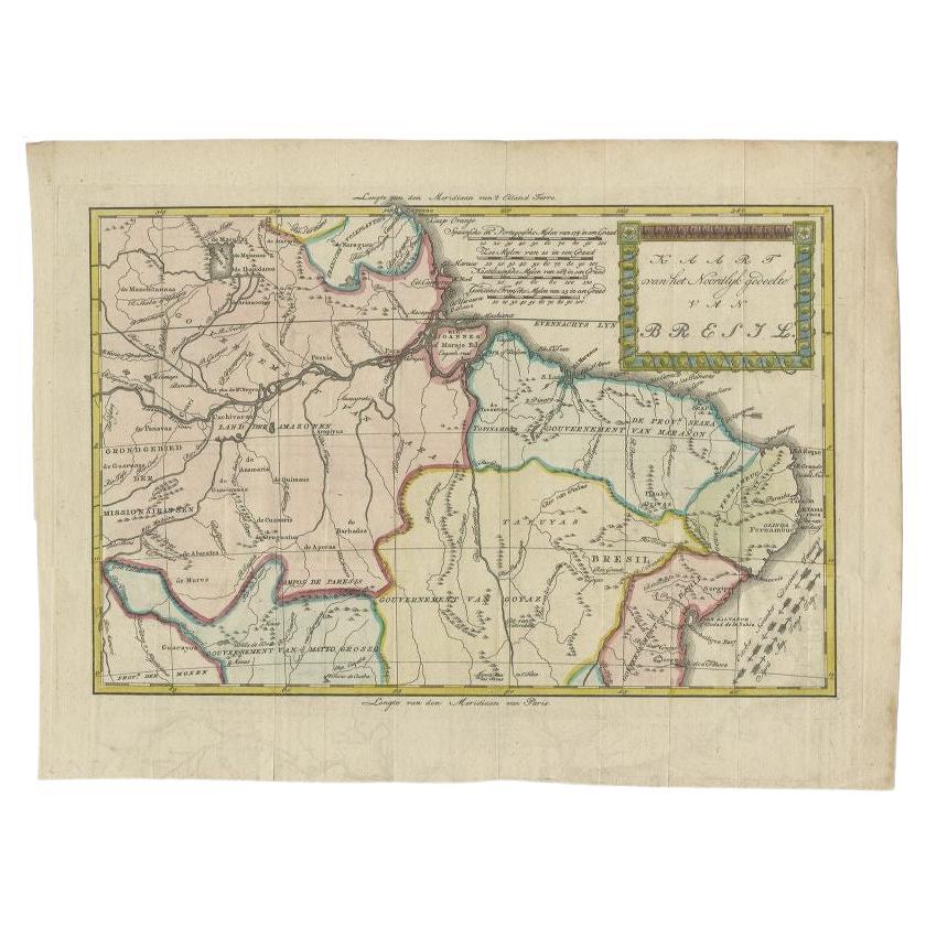
Antique Map of the Northern Part of Brazil by Raynal, 1784
Located in Langweer, NL
Antique map titled 'Kaart van het Noordlijk gedeelte van Bresil'. Rare antique map of the northern part of Brazil, with the basin of the Amazon and the cities of Manaus, Recife and S...
Category
Antique 18th Century Maps
Materials
Paper
$216 Sale Price
20% Off
Antique Map of South America Depicting Guayana, c.1780
Located in Langweer, NL
Antique map titled 'La Guyane Francopise avec partie de la Guyane Hollandoise: suivant les Operations et les Cartes recentes des Ingenieurs-Geographes Francois'. Antique map of South...
Category
Antique 18th Century Maps
Materials
Paper

$333 Sale Price
20% Off
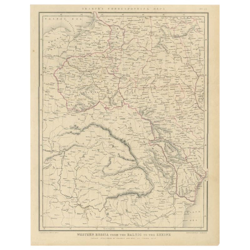
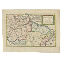
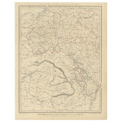
Antique Map of Russia from the Baltic to the Black Sea by Sharpe, 1849
Located in Langweer, NL
Antique map titled 'Western Russia from the Baltic to the Euxine'. Old map of Western Russia from the Baltic to the Black Sea. This map originates from 'Sharpe's Corresponding Atlas ...
Category
Antique 19th Century Maps
Materials
Paper
$90 Sale Price
20% Off
You May Also Like
1851 Map of "Independent Tartary", Ric. R018
Located in Norton, MA
1851 Map of
Independent Tartary
"Russia"
Ric.r018
A highly decorative 1851 map of Independent Tartary by John Tallis and John Rapkin. Covers the regions between the Caspian Sea and Lake Bakquash and between Russia and Afghanistan. These include the ancient Silk Route kingdoms of Khiva, Tartaria, Kokand, and Bokhara. Today this region roughly includes Kazakhstan, Uzbekistan, Turkmenistan, Kyrgyzstan, and Tajikistan. This wonderful map offers a wealth of detail for anyone with an interest in the Central Asian portion of the ancient Silk Road. Identifies various caravan routes, deserts, wells, and stopping points, including the cities of Bokhara and Samarkand. Three vignettes by W. Bragg decorate the map, these including an image of Tartars on a Journey, a horseback Bride Chase, and a tartar camp site. Surrounded by a vine motif border. Engraved by J. Rapkin for John Tallis's 1851 Illustrated Atlas .
Tartary Antique Map...
Category
Antique 19th Century Unknown Maps
Materials
Paper

Large Original Antique Map of Java and Borneo, Fullarton, C.1870
Located in St Annes, Lancashire
Great map of Java and Borneo
Wonderful figurative borders
From the celebrated Royal Illustrated Atlas
Lithograph. Original color.
Published by Fullarton, Edinburgh. C.1870
Unfr...
Category
Antique 1870s Scottish Maps
Materials
Paper

1839 Map of Karte Des "Russischen Reiches in Europa Und Asien" Ric.R0013
Located in Norton, MA
1839 map of Karte Des
"Russischen Reiches in Europa and Asien"
Ric.r013
Map of the European and Asian parts of Russian Empire. Karte der Russischen Reiches in Europa und Asien...
Category
Antique 19th Century Unknown Maps
Materials
Paper

Original Antique English County Map - Monmouthshire. J & C Walker. 1851
Located in St Annes, Lancashire
Great map of Monmouthshire
Original colour
By J & C Walker
Published by Longman, Rees, Orme, Brown & Co. 1851
Unframed.
Category
Antique 1850s English Other Maps
Materials
Paper

Original Antique Map of Central America / Florida, Arrowsmith, 1820
Located in St Annes, Lancashire
Great map of Central America.
Drawn under the direction of Arrowsmith.
Copper-plate engraving.
Published by Longman, Hurst, Rees, Orme and Brown, 1820
Unframed.
Category
Antique 1820s English Maps
Materials
Paper

Original Antique Map of Hungary, Arrowsmith, 1820
Located in St Annes, Lancashire
Great map of Hungary
Drawn under the direction of Arrowsmith.
Copper-plate engraving.
Published by Longman, Hurst, Rees, Orme and Brown, 1820
Unframed.
Category
Antique 1820s English Maps
Materials
Paper

More Ways To Browse
Devil Furniture
Antique Devil
Antique Maps Dublin
Georgetown Galleries Furniture
Georgetown Map
Antique Navigator
Map Of Middle East
Antique Map Of Switzerland
World Map Copper
British Empire Map
Malaysian Antique Furniture
Birds Eye View Map
Map Of Arabia
Map Of Vienna
Old School Maps
Balinese Wood
Joan Blaeu
Antique Nautical Maps