Items Similar to Antique Map of the City of Zürich, 1889


Want more images or videos?
Request additional images or videos from the seller
1 of 5
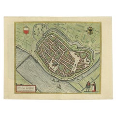
Antique Map of the City of Zürich, 1889
On Hold
$238.85
On Hold
£176.62
On Hold
€200
On Hold
CA$328.08
On Hold
A$364.81
On Hold
CHF 190.98
On Hold
MX$4,456.22
On Hold
NOK 2,399.91
On Hold
SEK 2,257.59
On Hold
DKK 1,522.85
About the Item
Antique map titled 'Grundriss und ussgemässne Verzeynuss der wyte Becirckh und Innhalts dess genanten Stadelhoffer Zehendens der Stifft S. Felix und Regula zum Grossen Münster alhie zu Zürich zugehörig'. Plan of Zürich (or Zurich), Switzerland, made after a map by Hans Konrad Gyger. This facsimile edition was published in 1889.
- Dimensions:Height: 19.3 in (49 cm)Width: 24.81 in (63 cm)Depth: 0.02 in (0.5 mm)
- Materials and Techniques:
- Period:
- Date of Manufacture:1889
- Condition:General age-related toning. Printed on very thin paper. Blank verso, minor wear. Please study images carefully.
- Seller Location:Langweer, NL
- Reference Number:Seller: BG-12237-71stDibs: LU3054317515591
About the Seller
5.0
Recognized Seller
These prestigious sellers are industry leaders and represent the highest echelon for item quality and design.
Platinum Seller
Premium sellers with a 4.7+ rating and 24-hour response times
Established in 2009
1stDibs seller since 2017
2,604 sales on 1stDibs
Typical response time: <1 hour
- ShippingRetrieving quote...Shipping from: Langweer, Netherlands
- Return Policy
Authenticity Guarantee
In the unlikely event there’s an issue with an item’s authenticity, contact us within 1 year for a full refund. DetailsMoney-Back Guarantee
If your item is not as described, is damaged in transit, or does not arrive, contact us within 7 days for a full refund. Details24-Hour Cancellation
You have a 24-hour grace period in which to reconsider your purchase, with no questions asked.Vetted Professional Sellers
Our world-class sellers must adhere to strict standards for service and quality, maintaining the integrity of our listings.Price-Match Guarantee
If you find that a seller listed the same item for a lower price elsewhere, we’ll match it.Trusted Global Delivery
Our best-in-class carrier network provides specialized shipping options worldwide, including custom delivery.More From This Seller
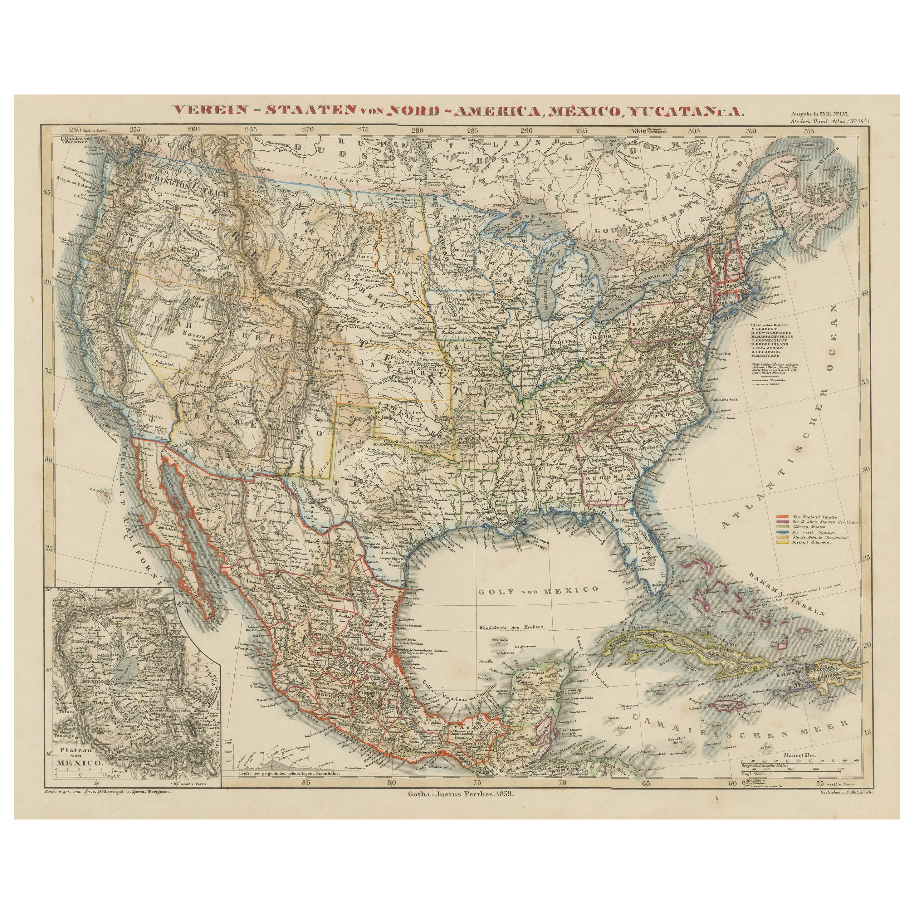
View AllAntique Map of the United States with inset map of the region of Mexico City
Located in Langweer, NL
Antique map titled 'Verein-Staaten von Nord-America, Mexico, Yucatan u.a.'. Very detailed map of the United States of America showing the Caribbean. With an inset map of the surround...
Category
Antique Mid-19th Century Maps
Materials
Paper

$821 Sale Price
20% Off
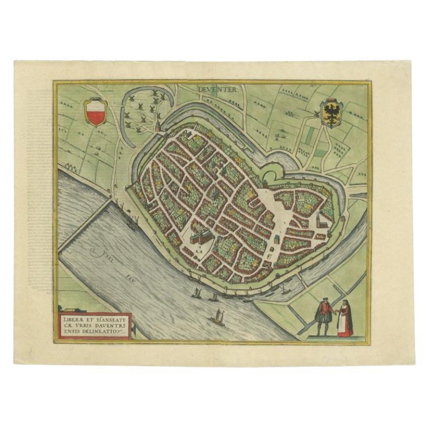
Antique Original Map of the City of Deventer, the Netherlands, 1588
Located in Langweer, NL
Antique map titled 'Liberae et Hanseaticae urbis Daventriensis delineatio'.
Original bird's eye plan of the Dutch hanseatic city Deventer, on the situated IJssel river. This map ...
Category
Antique 16th Century Maps
Materials
Paper
$754 Sale Price
20% Off
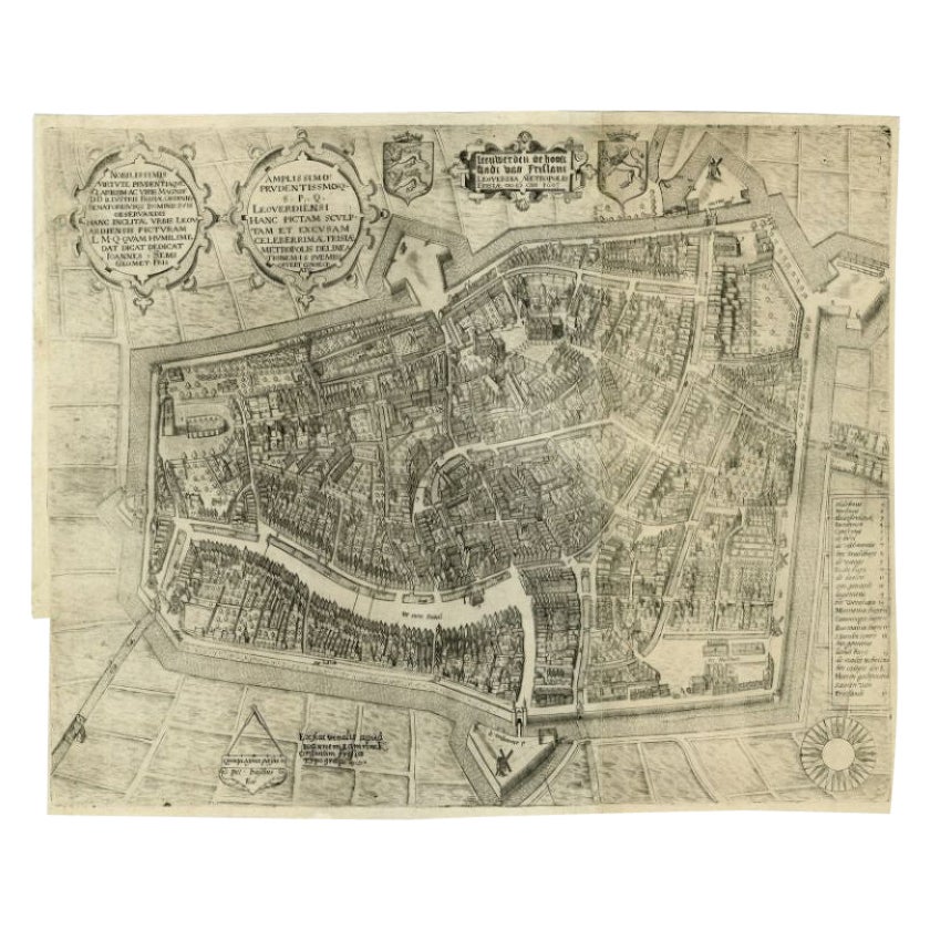
Antique Map of the City of Leeuwarden by Bast, 1603
Located in Langweer, NL
Antique map titled 'Leeuwerden de hooft stadt van Frislant. Leoverdia Metropolis Frisiae (…) 1603.' Very rare plan of Leeuwarden, Friesland, The Netherlands. With several carouches a...
Category
Antique 17th Century Maps
Materials
Paper

$2,603 Sale Price
20% Off
Antique Map of the City of Paris by Tirion '1763'
Located in Langweer, NL
Antique map titled 'Nieuwe Kaart der platte Grond van de Stad Parys (..)'. Beautiful city plan of Paris, France. This map originates from 'Nieuwe en Beknopte Hand-Atlas, bestaande in...
Category
Antique Mid-18th Century Maps
Materials
Paper

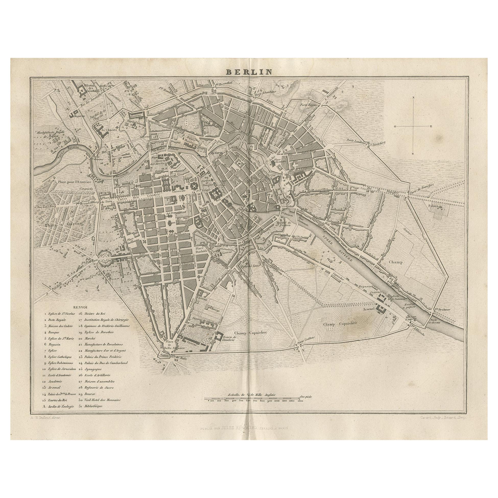
Antique Map of the City of Berlin in Germany, '1847'
Located in Langweer, NL
Antique map titled 'Berlin'. Original antique map of the city of Berlin, Germany. This map originates from 'Abrégé de Géographie (..)' by Adrien Balbi. Published 1847.
Category
Antique Mid-19th Century Maps
Materials
Paper

$143 Sale Price
20% Off
Antique Map of the City of London by Balbi '1847'
Located in Langweer, NL
Antique map titled 'London'. Original antique map of the city of London. This map originates from 'Abrégé de Géographie (..)' by Adrien Balbi. Published 1847.
Category
Antique Mid-19th Century Maps
Materials
Paper

$191 Sale Price
20% Off
You May Also Like
Map of the Republic of Genoa
Located in New York, NY
Framed antique hand-coloured map of the Republic of Genoa including the duchies of Mantua, Modena, and Parma.
Europe, late 18th century.
Dimension: 25...
Category
Antique Late 18th Century European Maps

Antique Map of Principality of Monaco
By Antonio Vallardi Editore
Located in Alessandria, Piemonte
ST/619 - "Old Geographical Atlas of Italy - Topographic map of ex-Principality of Monaco" -
ediz Vallardi - Milano -
A somewhat special edition ---
Category
Antique Late 19th Century Italian Other Prints
Materials
Paper

Original Antique Map of The World by Thomas Clerk, 1817
Located in St Annes, Lancashire
Great map of The Eastern and Western Hemispheres
On 2 sheets
Copper-plate engraving
Drawn and engraved by Thomas Clerk, Edinburgh.
Published by Mackenzie And Dent, 1817
...
Category
Antique 1810s English Maps
Materials
Paper

Antique 18th Century Map of the Province of Pensilvania 'Pennsylvania State'
Located in Philadelphia, PA
A fine antique of the colony of Pennsylvania.
Noted at the top of the sheet as a 'Map of the province of Pensilvania'.
This undated and anonymous map is thought to be from the Gentleman's Magazine, London, circa 1775, although the general appearance could date it to the 1760's.
The southern boundary reflects the Mason-Dixon survey (1768), the western boundary is placed just west of Pittsburgh, and the northern boundary is not marked.
The map has a number of reference points that likely refer to companion text and appear to be connected to boundaries. The western and southern boundaries are marked Q, R, S, for example. A diagonal line runs from the Susquehanna R to the Lake Erie P. A broken line marked by many letters A, B, N, O, etc., appears in the east.
There are no latitude or longitude markings, blank verso.
Framed in a shaped contemporary gilt wooden frame and matted under a cream colored matte.
Bearing an old Graham Arader Gallery...
Category
Antique 18th Century British American Colonial Maps
Materials
Paper

Map "Estuary- Mouth of the Thames"
Located in Alessandria, Piemonte
ST/426 - Antique French Map of the estuary of the Thames, map dated 1769 -
"Mape of the entrance of the Thames. Designed by filing of Navy cards fo...
Category
Antique Mid-18th Century French Other Prints
Materials
Paper

Original Antique Map of South America. C.1780
Located in St Annes, Lancashire
Great map of South America
Copper-plate engraving
Published C.1780
Two small worm holes to left side of map
Unframed.
Category
Antique Early 1800s English Georgian Maps
Materials
Paper

More Ways To Browse
Antique Maps Of Italy
Antique Map India
Antique Topographic Maps
Antique Railroad
Antique Maps Of Africa
Railroad Furniture
Antiques Compasses
Antique House Plans
Antique Navigation
Colonial Furniture Company
Mississippi Furniture
Antique Scottish Wood Furniture
Indonesia Map
Antique Framed Map Engravings
Atlas Furniture Company
Used Office Furniture Edinburgh
Antique 16th Century Plates
Scotland Map