Items Similar to Antique Map of Java in 4 sheets by Dornseiffen, 1884


Want more images or videos?
Request additional images or videos from the seller
1 of 5
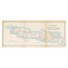
Antique Map of Java in 4 sheets by Dornseiffen, 1884
$620.34
$775.4320% Off
£458.57
£573.2120% Off
€520
€65020% Off
CA$860.44
CA$1,075.5620% Off
A$938.07
A$1,172.5920% Off
CHF 495.66
CHF 619.5720% Off
MX$11,536.09
MX$14,420.1120% Off
NOK 6,163.13
NOK 7,703.9120% Off
SEK 5,801.77
SEK 7,252.2120% Off
DKK 3,959.53
DKK 4,949.4220% Off
About the Item
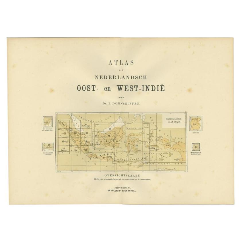
Detailed map of Java in 4 sheets, with an inset map of Batavia (Jakarta). This map originates from 'Atlas van Nederlandsch Oost- en West-Indie' by Dr. I. Dornseiffen. Published by Seyffardt's Boekhandel, Amsterdam.
- Dimensions:Height: 19.3 in (49 cm)Width: 15.36 in (39 cm)Depth: 0.02 in (0.5 mm)
- Materials and Techniques:
- Period:
- Date of Manufacture:1884
- Condition:Wear consistent with age and use. General age-related toning, please study images carefully. Provided measurements are for each individual sheet.
- Seller Location:Langweer, NL
- Reference Number:Seller: BG-120541stDibs: LU3054316279121
About the Seller
5.0
Recognized Seller
These prestigious sellers are industry leaders and represent the highest echelon for item quality and design.
Platinum Seller
Premium sellers with a 4.7+ rating and 24-hour response times
Established in 2009
1stDibs seller since 2017
2,620 sales on 1stDibs
Typical response time: <1 hour
- ShippingRetrieving quote...Shipping from: Langweer, Netherlands
- Return Policy
Authenticity Guarantee
In the unlikely event there’s an issue with an item’s authenticity, contact us within 1 year for a full refund. DetailsMoney-Back Guarantee
If your item is not as described, is damaged in transit, or does not arrive, contact us within 7 days for a full refund. Details24-Hour Cancellation
You have a 24-hour grace period in which to reconsider your purchase, with no questions asked.Vetted Professional Sellers
Our world-class sellers must adhere to strict standards for service and quality, maintaining the integrity of our listings.Price-Match Guarantee
If you find that a seller listed the same item for a lower price elsewhere, we’ll match it.Trusted Global Delivery
Our best-in-class carrier network provides specialized shipping options worldwide, including custom delivery.More From This Seller
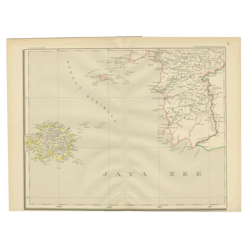
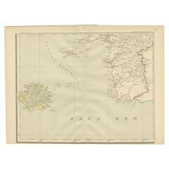
View AllAntique Map of the Java Sea by Dornseiffen, 1900
Located in Langweer, NL
Antique map of the Java Sea. Also depicts Bilitung, the Karimata Islands and Sukadana, Borneo. This map originates from 'Atlas van Nederlandsch Oost- en West-Indië' by I. Dornseiffen...
Category
20th Century Maps
Materials
Paper
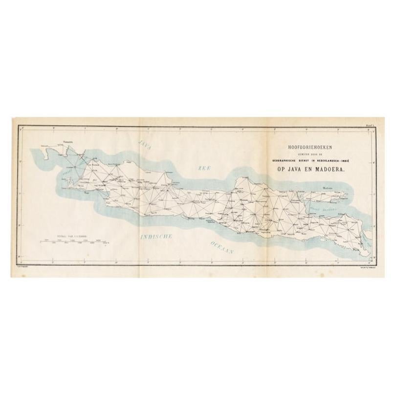
Old Map of Java, Indonesia by Stemler, 1875
By Stemler
Located in Langweer, NL
Antique map titled 'Hoofddriehoeken - Java en madoera.' (Main triangles measured by the Geographical Service in the Dutch-Indies on Java and Madoera.) This scarce map shows the Indon...
Category
Antique 19th Century Maps
Materials
Paper
$66 Sale Price
20% Off
Antique Map of the Region of Lampung, Sumatra, Indonesia, 1900
Located in Langweer, NL
Antique map of the region of Lampung, Sumatra. Also depicting part of Palembang and Java. This map originates from 'Atlas van Nederlandsch Oost- en West-Indië' by I. Dornseiffen.
A...
Category
20th Century Maps
Materials
Paper

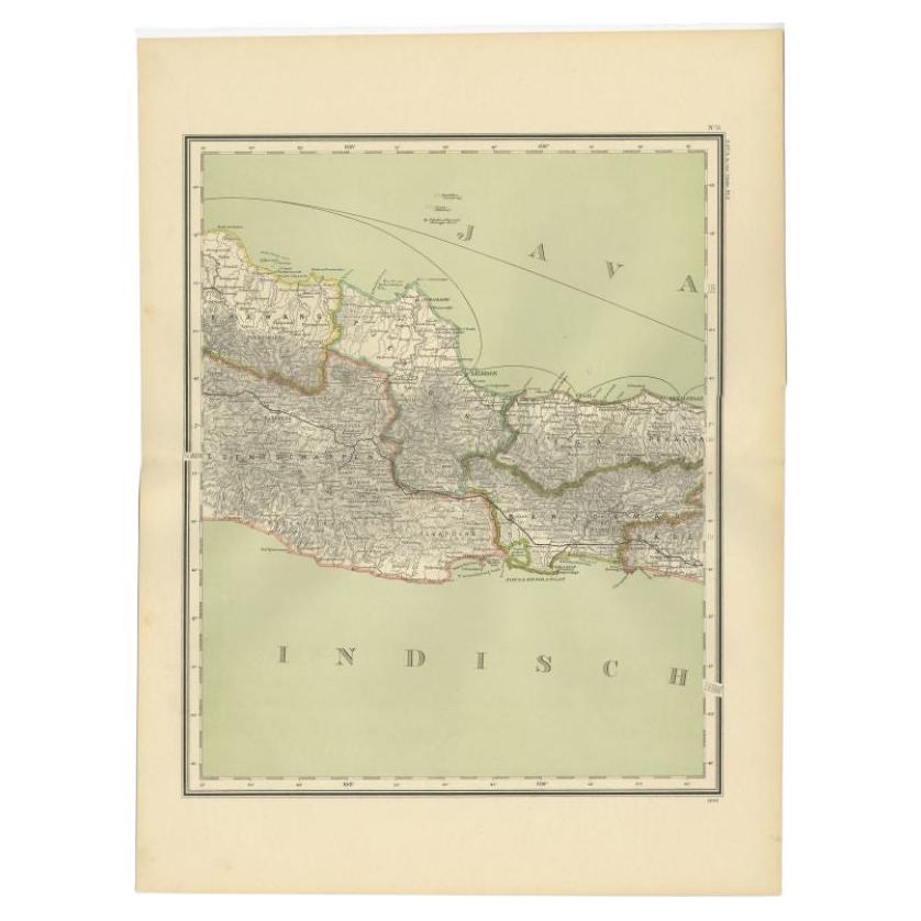
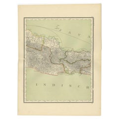
Antique Map of Part of Java, Indonesia, 1900
Located in Langweer, NL
Antique map of West Java. This map originates from 'Atlas van Nederlandsch Oost- en West-Indië' by I. Dornseiffen.
Artists and Engravers: Published by Seyffardt's Boekhandel, Amste...
Category
20th Century Maps
Materials
Paper
$276 Sale Price
20% Off
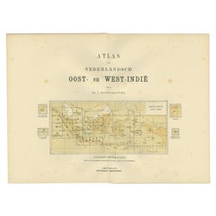
Antique Map of the East Indies by Dornseiffen, 1900
Located in Langweer, NL
Title page of 'Atlas van Nederlandsch Oost- en West-Indië' by I. Dornseiffen. It shows the regions of the various maps included in this atlas. Included are the Dutch East Indies and ...
Category
20th Century Maps
Materials
Paper
$133 Sale Price
20% Off
Antique Map of the East Indies by Van der Aa '1849'
Located in Langweer, NL
Antique map titled 'Kaart van Nederlands OostIndie door A.J. van der Aa'. Old map of the Dutch East Indies. This map originates from 'Nederlands Oost-Indië, of beschrijving der Neder...
Category
Antique Mid-19th Century Maps
Materials
Paper

$381 Sale Price
20% Off
You May Also Like
Large Original Antique Map of Java and Borneo, Fullarton, C.1870
Located in St Annes, Lancashire
Great map of Java and Borneo
Wonderful figurative borders
From the celebrated Royal Illustrated Atlas
Lithograph. Original color.
Published by Fullarton, Edinburgh. C.1870
Unfr...
Category
Antique 1870s Scottish Maps
Materials
Paper

Large Original Antique Map of The Bahamas. 1894
Located in St Annes, Lancashire
Superb Antique map of The Bahamas
Published Edward Stanford, Charing Cross, London 1894
Original colour
Good condition
Unframed.
Free shipping
Category
Antique 1890s English Maps
Materials
Paper

Antique 1803 Italian Map of Asia Including China Indoneseia India
Located in Amsterdam, Noord Holland
Antique 1803 Italian Map of Asia Including China Indoneseia India
Very nice map of Asia. 1803.
Additional information:
Type: Map
Country of Manufacturing: Europe
Period: 19th centu...
Category
Antique 19th Century European Maps
Materials
Paper

$584 Sale Price
20% Off
Antique Lithography Map, West Africa, English, Framed, Cartography, Victorian
Located in Hele, Devon, GB
This is an antique lithography map of Western Africa. An English, framed atlas engraving of cartographic interest by John Rapkin, dating to the early Victorian period and later, circ...
Category
Antique Mid-19th Century British Early Victorian Maps
Materials
Wood

Large Original Antique Map of The Canary Islands. 1894
Located in St Annes, Lancashire
Superb Antique map of The Canary Islands
Published Edward Stanford, Charing Cross, London 1894
Original colour
Good condition
Unframed.
Free shipping
Category
Antique 1890s English Maps
Materials
Paper

Original Antique Map of South East Asia by Thomas Clerk, 1817
Located in St Annes, Lancashire
Great map of South East Asia
Copper-plate engraving
Drawn and engraved by Thomas Clerk, Edinburgh.
Published by Mackenzie And Dent, 1817
Unframed.
Category
Antique 1810s English Maps
Materials
Paper
