Items Similar to Antique Map of the Kingdom of Sweden and Norway by Keizer & de Lat, 1788


Want more images or videos?
Request additional images or videos from the seller
1 of 5
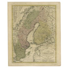
Antique Map of the Kingdom of Sweden and Norway by Keizer & de Lat, 1788
$331.97
$414.9620% Off
£248.44
£310.5520% Off
€280
€35020% Off
CA$457.98
CA$572.4720% Off
A$509.29
A$636.6120% Off
CHF 267.49
CHF 334.3620% Off
MX$6,226.58
MX$7,783.2220% Off
NOK 3,333.18
NOK 4,166.4820% Off
SEK 3,142.29
SEK 3,927.8620% Off
DKK 2,131.50
DKK 2,664.3720% Off
About the Item
Antique map titled 't Koninkryk van Zweden en Noorwegen'. Uncommon original antique map of the Kingdom of Sweden and Norway. This map originates from 'Nieuwe Natuur- Geschied- en Handelkundige Zak- en Reisatlas' by Gerrit Brender à Brandis. Published by J. Keizer and I. de Lat, 1788.
- Dimensions:Height: 10.63 in (27 cm)Width: 7.88 in (20 cm)Depth: 0.02 in (0.5 mm)
- Materials and Techniques:
- Period:
- Date of Manufacture:1788
- Condition:General age-related toning. Original folding lines. Original/contemporary hand coloring, blank verso. Minor wear, please study image carefully.
- Seller Location:Langweer, NL
- Reference Number:Seller: BG-12854-431stDibs: LU3054321979072
About the Seller
5.0
Recognized Seller
These prestigious sellers are industry leaders and represent the highest echelon for item quality and design.
Platinum Seller
Premium sellers with a 4.7+ rating and 24-hour response times
Established in 2009
1stDibs seller since 2017
2,609 sales on 1stDibs
Typical response time: <1 hour
- ShippingRetrieving quote...Shipping from: Langweer, Netherlands
- Return Policy
Authenticity Guarantee
In the unlikely event there’s an issue with an item’s authenticity, contact us within 1 year for a full refund. DetailsMoney-Back Guarantee
If your item is not as described, is damaged in transit, or does not arrive, contact us within 7 days for a full refund. Details24-Hour Cancellation
You have a 24-hour grace period in which to reconsider your purchase, with no questions asked.Vetted Professional Sellers
Our world-class sellers must adhere to strict standards for service and quality, maintaining the integrity of our listings.Price-Match Guarantee
If you find that a seller listed the same item for a lower price elsewhere, we’ll match it.Trusted Global Delivery
Our best-in-class carrier network provides specialized shipping options worldwide, including custom delivery.More From This Seller
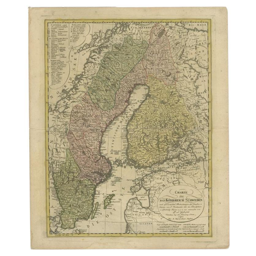
View AllSweden and Scandinavia – Antique Map by F.L. Güssefeld, Homann Heirs, c.1793s
Located in Langweer, NL
Sweden and Scandinavia – Antique Map by F.L. Güssefeld, Homann Heirs, c.1793s
This finely engraved antique map, titled Charte über das Königreich Schweden, presents an expansive vie...
Category
Antique 18th Century German Maps
Materials
Paper
$227 Sale Price
20% Off
Antique Map of Scandinavia by T. Jefferys, circa 1750
Located in Langweer, NL
Antique map titled 'Sweden, Denmark, Norway & Finland'. An original mid-18th century copper engraved antique map of Scandinavia by Thomas Jefferys....
Category
Antique Mid-18th Century Maps
Materials
Paper

$180 Sale Price
20% Off
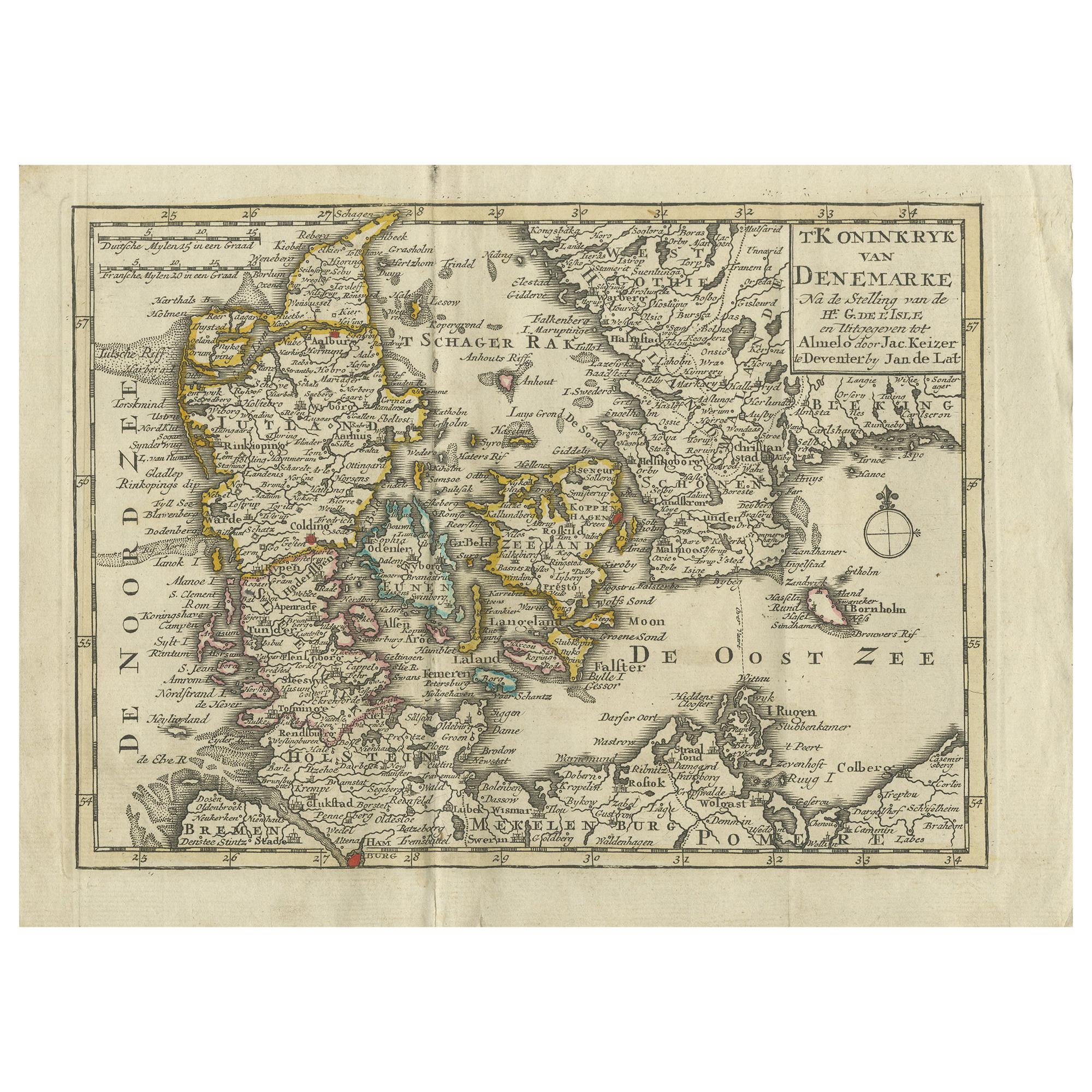
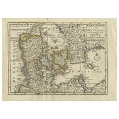
Antique Map of the Kingdom of Denmark by Keizer & de Lat, 1788
Located in Langweer, NL
Antique map titled 't Koninkryk van Denemarke'. Uncommon original antique map of the Kingdom of Denmark. This map originates from 'Nieuwe Natuur- Geschied- en Handelkundige Zak- en R...
Category
Antique Late 18th Century Maps
Materials
Paper
$331 Sale Price
20% Off
Antique Map of Sweden by Bowen, 1747
Located in Langweer, NL
Antique map titled 'A New & Accurate Map of Sweden'. This map covers Sweden and Finland (shown as part of Sweden) as well as parts of modern day Estonia,...
Category
Antique 18th Century Maps
Materials
Paper

$256 Sale Price
20% Off
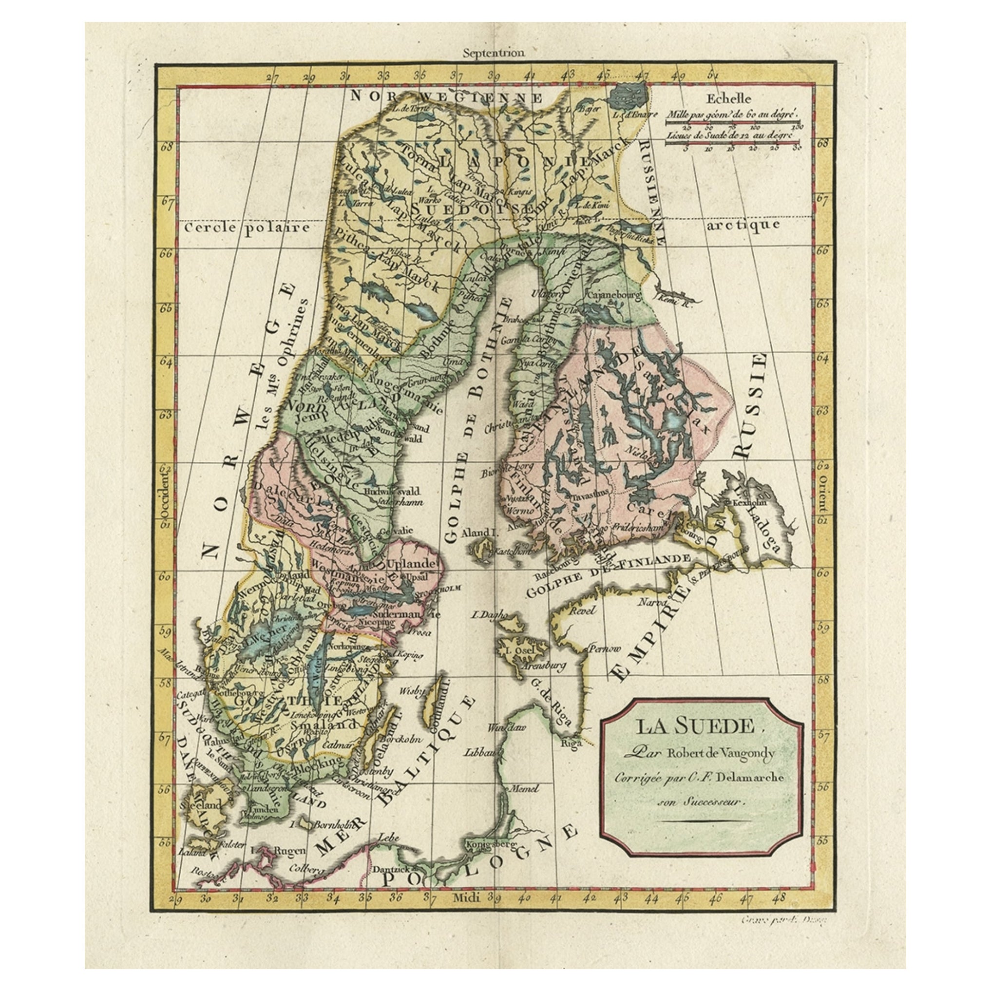
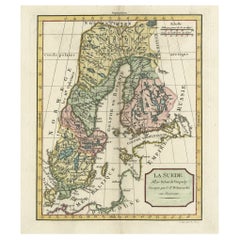
Decorative Antique Map of Sweden and Part of Finland, 1806
Located in Langweer, NL
Antique map titled 'La Suede.'
Decorative map of Sweden and part of Finland by Robert de Vaugondy, revised and published by Delamarche. Source unknown, to be determined.
Artists and Engravers: Made by 'Charles Francois Delamarche' after an anonymous artist. Charles Francois Delamarche (1740-1817) founded the important and prolific Paris based Maison Delamarche map publishing firm in the late 18th century. A lawyer by trade Delamarche entered the map business with the acquisition from Jean-Baptiste Fortin of Robert de Vaugondy's map plates...
Category
Antique Early 1800s French Maps
Materials
Paper
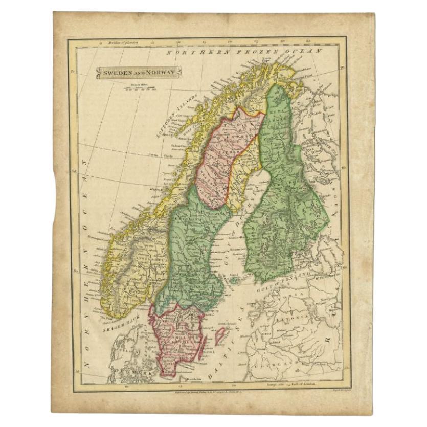
Antique Map of Sweden and Norway by Russell, 1814
Located in Langweer, NL
Antique map Scandinavia titled 'Sweden & Norway'. Antique map of Scandinavia with a focus on Sweden and Norway. Artists and Engravers: Engrave...
Category
Antique 19th Century Maps
Materials
Paper

$85 Sale Price
20% Off
You May Also Like
Original Antique Map of Sweden, Engraved by Barlow, 1806
Located in St Annes, Lancashire
Great map of Sweden
Copper-plate engraving by Barlow
Published by Brightly & Kinnersly, Bungay, Suffolk. 1806
Unframed.
Category
Antique Early 1800s English Maps
Materials
Paper

Sweden and Adjacent Portions of Scandinavia: A Hand-colored 18th C. Homann Map
By Johann Baptist Homann
Located in Alamo, CA
This hand-colored copper-plate map of Sweden and adjacent portions of Scandinavia entitled "Regni Sueciae in Omnes suas Subjacentes Provincias accurate divisi Tabula Generalis" was c...
Category
Early 18th Century Old Masters Landscape Prints
Materials
Engraving

Ancient Map of Denmark and Sweden - Original Etching - 19th Century
By Giuseppe Malandrino
Located in Roma, IT
This Map of Denmark and Sweden is an etching realized by an anonymous artist.
The state of preservation of the artwork is good with some small diffused stains.
Sheet dimension: 27x...
Category
Late 19th Century Modern Figurative Prints
Materials
Etching

1646 Jansson Map Entitled "Procinvia Connactiae, " Ric.a006
Located in Norton, MA
1646 Jansson map entitled
"Procinvia connactiae,"
Ric.a006
Description: The PROVINCE of CONNAVGT 490 x 380From vol 4 of Jansson's Atlas Novus 1646, published in Amsterdam with...
Category
Antique 17th Century Unknown Maps
Materials
Paper

Original Antique Map of Switzerland, Engraved By Barlow, Dated 1807
Located in St Annes, Lancashire
Great map of Switzerland
Copper-plate engraving by Barlow
Published by Brightly & Kinnersly, Bungay, Suffolk.
Dated 1807
Unframed.
Category
Antique Early 1800s English Maps
Materials
Paper

Von Reilly Map of the Russian Empire, 1796
Located in Savannah, GA
A map of the Russian Empire in Europe by Von Reilly. Published in Vienna, 1796.
32 inches wide by 24 ½ inches tall
Category
Antique 1790s Austrian Prints
Materials
Glass, Wood, Paper

More Ways To Browse
18th Century Norwegian
Framed World Map
Rare Compass
16th Century Scotland
Antique Wood Coat Of Arms
Antique Maps Australia
Antique Quadrant
Caribbean Antique Furniture
Antique Native American Collectibles
Turkey Map
Map Of Austria
Antique Mediterranean Map
Antique Furniture Building Plans
Map Of Ireland
18th Century Compass
18th Century Maps America
Map Of Great Britain
Miniature Maps