Items Similar to Antique Map of Northern Germany and the Netherlands – circa 1806


Want more images or videos?
Request additional images or videos from the seller
1 of 6
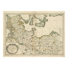
Antique Map of Northern Germany and the Netherlands – circa 1806
$131.38
£97.35
€110
CA$181.74
A$200.29
CHF 104.86
MX$2,460.21
NOK 1,317.58
SEK 1,233.15
DKK 837.73
About the Item
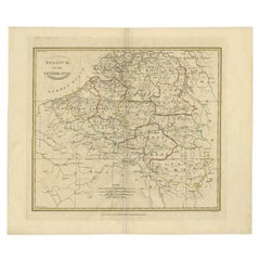
Title: Antique Map of Northern Germany and the Netherlands – circa 1806
Description: This finely engraved antique map, titled L'Allemagne 1re Feuille, depicts the northern regions of Germany, the Netherlands, and part of England. The map is from an 18th-century or early 19th-century French atlas and showcases detailed geographical information, including cities, rivers, and political boundaries of the period. The coastlines of the North Sea (Mer d'Allemagne) are well-defined, with major port cities such as Amsterdam, Hamburg, and Bremen clearly marked. England's eastern coastline, including London, Yarmouth, and Ipswich, is also featured.
The map includes a scale conversion chart in the upper left corner, allowing for measurements in various units, including German miles, French leagues, and marine leagues. The hand-colored borders distinguish different political entities, reflecting the fragmented nature of the Holy Roman Empire at the time.
Condition Report:
Paper Quality: High-quality 18th-century paper with a natural warm tone.
Engraving: Crisp and well-detailed, with clear typography.
Coloring: Hand-applied border colors remain vibrant.
Margins: Wide margins with minor toning and light foxing.
Overall Condition: Good, with no major tears or losses.
Framing Tips:
Matting: Use an off-white or light cream acid-free mat to complement the antique appearance.
Glass: UV-resistant glass will help preserve the paper and prevent fading.
Frame Style: A dark wood or gilt frame enhances the historical character.
Mounting: Conservation-grade materials should be used to ensure longevity.
This is a highly detailed and historically significant map, perfect for collectors of European cartography or historical geography enthusiasts.
- Dimensions:Height: 7.88 in (20 cm)Width: 9.85 in (25 cm)Depth: 0.01 in (0.2 mm)
- Materials and Techniques:Paper,Engraved
- Period:
- Date of Manufacture:circa 1806
- Condition:Overall Condition: Good, with no major tears or losses.
- Seller Location:Langweer, NL
- Reference Number:Seller: BG-13094-51stDibs: LU3054343838272
About the Seller
5.0
Recognized Seller
These prestigious sellers are industry leaders and represent the highest echelon for item quality and design.
Platinum Seller
Premium sellers with a 4.7+ rating and 24-hour response times
Established in 2009
1stDibs seller since 2017
2,618 sales on 1stDibs
Typical response time: <1 hour
- ShippingRetrieving quote...Shipping from: Langweer, Netherlands
- Return Policy
Authenticity Guarantee
In the unlikely event there’s an issue with an item’s authenticity, contact us within 1 year for a full refund. DetailsMoney-Back Guarantee
If your item is not as described, is damaged in transit, or does not arrive, contact us within 7 days for a full refund. Details24-Hour Cancellation
You have a 24-hour grace period in which to reconsider your purchase, with no questions asked.Vetted Professional Sellers
Our world-class sellers must adhere to strict standards for service and quality, maintaining the integrity of our listings.Price-Match Guarantee
If you find that a seller listed the same item for a lower price elsewhere, we’ll match it.Trusted Global Delivery
Our best-in-class carrier network provides specialized shipping options worldwide, including custom delivery.More From This Seller
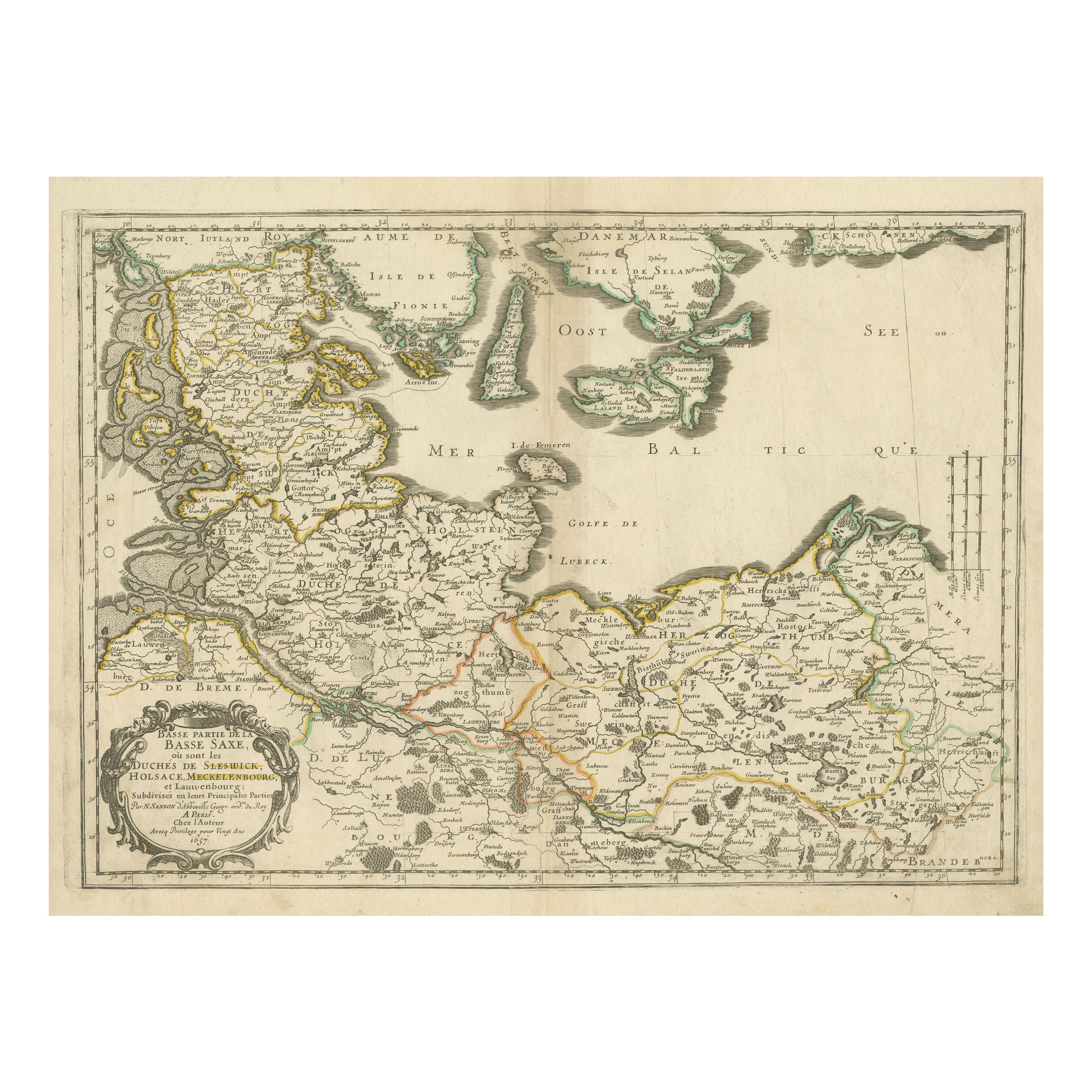
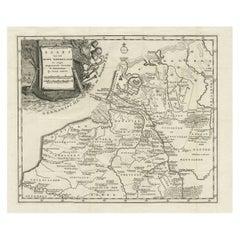
View AllAntique Map of Northern Germany, Including Schleswig-Holstein and Hamburg
Located in Langweer, NL
Antique map titled 'Basse Partie de la Basse Saxe ou sont les Duchés de Sleswick, Holsace, Meckelenbourg et Lauvenbourg (..)'. Original old map of northern Germany, including Schlesw...
Category
Antique Mid-17th Century Maps
Materials
Paper
$515 Sale Price
20% Off
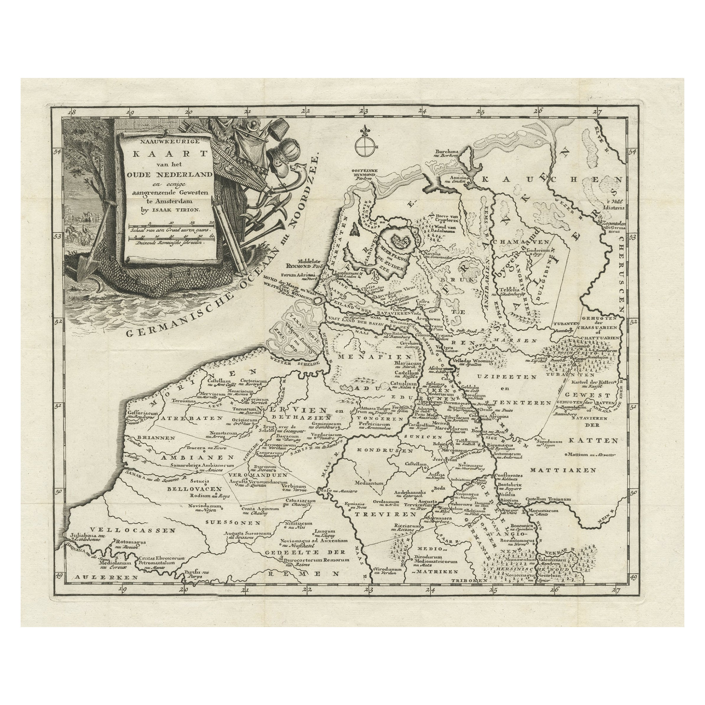
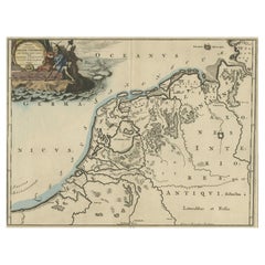
Original Antique Map of the Ancient Netherlands and Belgium, c.1750
Located in Langweer, NL
Description: Antique map titled 'Naauwkeurige Kaart van het Oude Nederland (..)'.
Original antique map of the Netherlands and Belgium. This map originates from 'Vaderlandsche his...
Category
Antique 1750s Maps
Materials
Paper
$334 Sale Price
20% Off
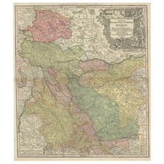
Antique Map of Part of Germany by Moll, c.1740
Located in Langweer, NL
Antique map Germany titled 'The North West Part of Germany; Containing ye Dominions of ye Arch: and El: of Cologne, Westphalia, / Juliers, Cleeves,...
Category
Antique 18th Century Maps
Materials
Paper

$109 Sale Price
20% Off
Antique Map of Friesland at a Time the Franks Left and Saxons Came, 1718
Located in Langweer, NL
Antique map Friesland titled 'Summaria descriptio Fresiae Universae (..)'.
Old map of Friesland, the Netherlands. Depicts the general delineation of Friesland during its widest s...
Category
Antique 18th Century Maps
Materials
Paper
$343 Sale Price
20% Off
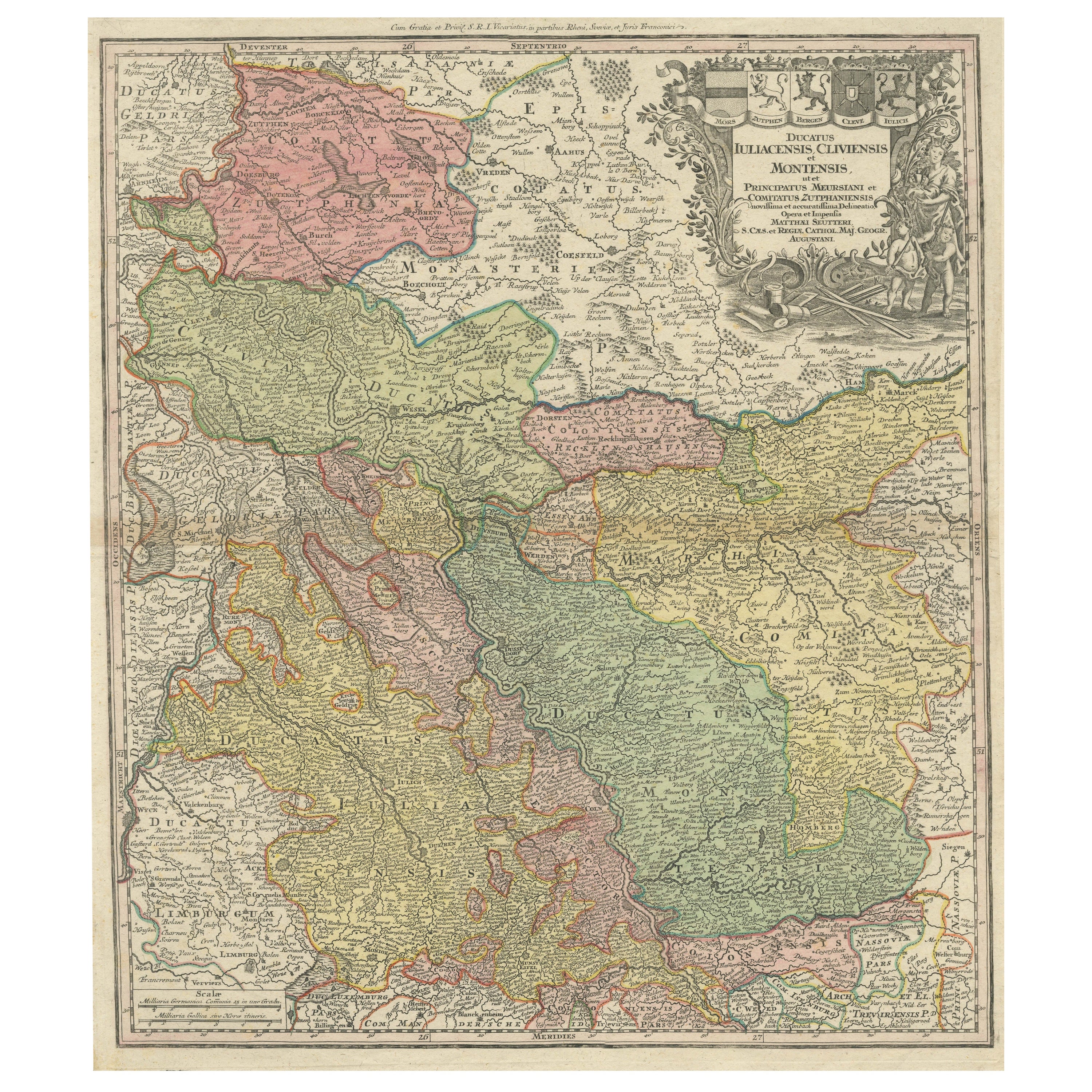
Antique Map of Western Germany with part of the Netherlands
Located in Langweer, NL
Antique map titled 'Ducatus Iuliacensis Cliviensis et Montensis (..)'. Original old map of Western Germany with part of the Netherlands. Published by M. Seutter, circa 1750.
George...
Category
Antique Mid-18th Century Maps
Materials
Paper
$429 Sale Price
20% Off
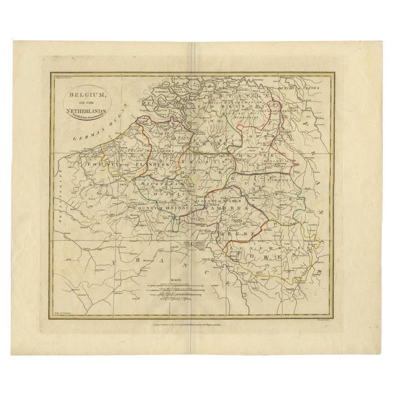
Antique Map of Belgium and Part of the Southern Netherlands, 1810
Located in Langweer, NL
Antique map titled 'Belgium, or the Netherlands divided into Departments'. Original antique map of Belgium and the southern part of the Netherlands. This map originates from 'The Mod...
Category
Antique 19th Century Maps
Materials
Paper
$238 Sale Price
20% Off
You May Also Like
1752 Vaugoundy Map of Flanders : Belgium, France, and the Netherlands, Ric.a002
Located in Norton, MA
Large Vaugoundy Map of Flanders:
Belgium, France, and the Netherlands
Colored -1752
Ric.a002
Description: This is a 1752 Didier Robert de Vaugondy map of Flanders. The map de...
Category
Antique 17th Century Unknown Maps
Materials
Paper

1790 Thomas Stackhouse Map, Entitled "Russia in Europe, " , Ric.a004
Located in Norton, MA
1790 Thomas Stackhouse map, entitled
"Russia in Europe"
Ric.a004
Stackhouse, Thomas
Russia in Europe [map]
London: T. Stackhouse, 1783. Map. Matted hand-colored copper engraving. Image size: 14.5 x 15.25 inches. Mat size: 22.75 x 23.75 inches. A beautiful example of this map of Eastern Europe...
Category
Antique 17th Century Unknown Maps
Materials
Paper

1643 Willem&Joan Blaeu Map NW Flanders "Flandriae Teutonicae Pars Prientalior
Located in Norton, MA
1643 Willem and Joan Blaeu map of northwest Flanders, entitled
"Flandriae Teutonicae Pars Prientalior,"
Ric0012
" Authentic" - Map of the northwest Fl...
Category
Antique 17th Century Dutch Maps
Materials
Paper

Original Antique Map of Europe, Arrowsmith, 1820
Located in St Annes, Lancashire
Great map of Europe
Drawn under the direction of Arrowsmith.
Copper-plate engraving.
Published by Longman, Hurst, Rees, Orme and Brown, 1820
...
Category
Antique 1820s English Maps
Materials
Paper

Belgium and the Netherlands: A Hand-colored 17th Century Map by Visscher
By Nicolaus Visscher
Located in Alamo, CA
This is an original hand-colored 17th century map of Belgium by Nicolaus (Nicolas) Visscher II entitled "Belgium Foederatum emendate auctum et novissime editum", published in Amsterdam in 1678. The map shows the seven provinces comprising the Belgium federation or the Republic of the Seven United Netherlands or the Dutch Republic as it was also known. The republic was formed when an alliance of seven Dutch provinces in the Spanish Netherlands revolted against rule by Spain in 1579 (the Union of Utrecht) and declared their independence in 1581 (the Act of Abjuration). The seven provinces were Groningen, Frisia, Overijssel, Guelders, Utrecht, Holland and Zeeland. This was a predecessor state to the Netherlands and the first fully independent Dutch nation state. Amsterdam, Delft, Rouen, Utrecht, Brugge, Ghent, and Antwerp are all included on the map. A small inset map in the lower right depicts the course of the Maas River from Maastricht to Wessem. There is a decorative cartouche in the upper left corner and a distance scale cartouche in the lower right corner.
The map is presented in an attractive antiqued medium brown-colored wood frame with gold-colored inner and outer trim and a light tan-colored fabric mat. The frame measures 26.63" high by 30" wide by 0.75" deep. There is some darkening of the red areas in the map, presumably related to oxidation of the original iron containing pigment over time. There are also a few scattered spots. The map is otherwise in very good condition.
The Visscher family were one of the great cartographic families of the 17th century. Begun by Claes Jansz Visscher...
Category
Late 17th Century Other Art Style Landscape Prints
Materials
Engraving

Antique Colored Belgium Map Flandria Gallica Flanders Henricus Hondius
Located in Dayton, OH
Antique hand colored map of Flanders, Belgium, engraved by Henricus Hondius.
Sans frame - 21.25” x 18”.
Category
Antique 19th Century Renaissance Maps
Materials
Paper

$280 Sale Price
20% Off
More Ways To Browse
Antique Russian Rugs
Beni Ourain Rugs
Glass Top Wood Base Coffee Tables
Large Antique Tapestry Tapestries
Large Antique Tapestry
Mid Century Modern Corner Chair
Sterling Silver Flatware Set Service For 12
1970s Brass Glass Coffee Table
Lane Modern Furniture
Mid Century Sofa Red
Painted Arm Chairs
Vintage Azerbaijan
Charles Rennie Mackintosh For Cassina
Painted Bar Stools
3x5 Rugs
French Iron And Glass Table
Mcm Table
Tufted Bar