Items Similar to Antique Map of Oostergo by Von Reilly, 1791

Want more images or videos?
Request additional images or videos from the seller
1 of 5
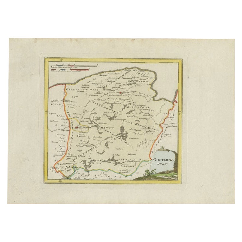
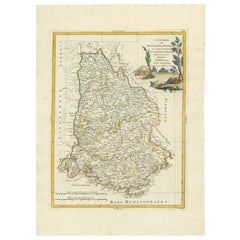
Antique Map of Oostergo by Von Reilly, 1791
$151.06
$188.8220% Off
£111.83
£139.7920% Off
€126.40
€15820% Off
CA$209.03
CA$261.2820% Off
A$230.41
A$288.0220% Off
CHF 120.56
CHF 150.7020% Off
MX$2,827.09
MX$3,533.8620% Off
NOK 1,517.65
NOK 1,897.0620% Off
SEK 1,419.24
SEK 1,774.0520% Off
DKK 962.41
DKK 1,203.0120% Off
About the Item
Antique map titled 'Der Provinz Oostergo sechs südliche Grietenyen'. Map of the Oostergo region, Friesland, the Netherlands. This map orginates from 'Schauplatz der fünf Theile der Welt'. Artists and Engravers: Franz Joseph Johann von Reilly (1766-1820) was a Vienna based art dealer. He is also known as the author of two atlases. The maps were engraved by Ignaz Alberti (also Ignaz Albrecht, 1760-1794). Ignaz was an Austrian illustrator, publisher and engraver.
Artist: Franz Joseph Johann von Reilly (1766-1820) was a Vienna based art dealer. He is also known as the author of two atlases. The maps were engraved by Ignaz Alberti (also Ignaz Albrecht, 1760-1794). Ignaz was an Austrian illustrator, publisher and engraver.
Condition: Good, general age-related toning. Original/contemporary hand coloring. Blank verso. Please study image carefully.
Date: 1791
Overall size: 39.5 x 29 cm.
Image size: 0.001 x 28 x 18 cm.
Antique prints have long been appreciated for both their aesthetic and investment value. They were the product of engraved, etched or lithographed plates. These plates were handmade out of wood or metal, which required an incredible level of skill, patience and craftsmanship. Whether you have a house with Victorian furniture or more contemporary decor an old engraving can enhance your living space. We offer a wide range of authentic antique prints for any budget.
- Dimensions:Height: 11.42 in (29 cm)Width: 15.56 in (39.5 cm)Depth: 0 in (0.01 mm)
- Materials and Techniques:
- Period:
- Date of Manufacture:1791
- Condition:
- Seller Location:Langweer, NL
- Reference Number:Seller: PCT-7331stDibs: LU3054327620532
About the Seller
5.0
Recognized Seller
These prestigious sellers are industry leaders and represent the highest echelon for item quality and design.
Platinum Seller
Premium sellers with a 4.7+ rating and 24-hour response times
Established in 2009
1stDibs seller since 2017
2,613 sales on 1stDibs
Typical response time: <1 hour
- ShippingRetrieving quote...Shipping from: Langweer, Netherlands
- Return Policy
Authenticity Guarantee
In the unlikely event there’s an issue with an item’s authenticity, contact us within 1 year for a full refund. DetailsMoney-Back Guarantee
If your item is not as described, is damaged in transit, or does not arrive, contact us within 7 days for a full refund. Details24-Hour Cancellation
You have a 24-hour grace period in which to reconsider your purchase, with no questions asked.Vetted Professional Sellers
Our world-class sellers must adhere to strict standards for service and quality, maintaining the integrity of our listings.Price-Match Guarantee
If you find that a seller listed the same item for a lower price elsewhere, we’ll match it.Trusted Global Delivery
Our best-in-class carrier network provides specialized shipping options worldwide, including custom delivery.More From This Seller
View AllAntique Map of Oostergo by Von Reilly, 1791
Located in Langweer, NL
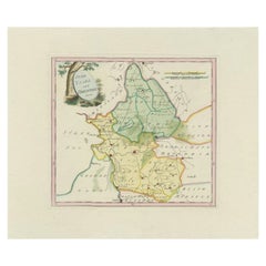
Antique map titled 'Oostergo'. Map of the Oostergo region, Friesland, the Netherlands. This map orginates from 'Schauplatz der fünf Theile der Welt'. Artists and Engravers: Franz Jos...
Category
Antique 18th Century Maps
Materials
Paper
$174 Sale Price
20% Off
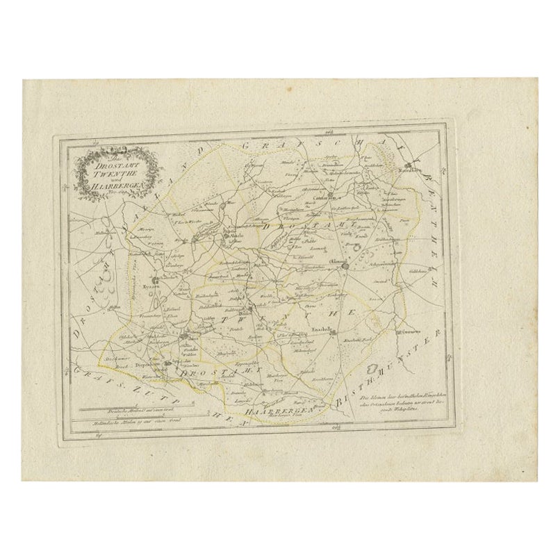
Antique Map of Part of Overijssel by Von Reilly, 1792
Located in Langweer, NL
Antique map titled 'Das Drostamt Twenthe und Haarbergen'. This map depicts part of The Netherlands (Overijssel). This map originates from 'Schauplatz der fünf Theile der Welt' publis...
Category
Antique 18th Century Maps
Materials
Paper
$119 Sale Price
20% Off
Antique Map of Friesland by Von Reilly, 1791
Located in Langweer, NL
Antique map titled 'Friesland'. Map of the province of Friesland, the Netherlands. This map orginates from 'Schauplatz der fünf Theile der Welt'. Artists and Engravers: Franz Joseph ...
Category
Antique 18th Century Maps
Materials
Paper

$186 Sale Price
20% Off
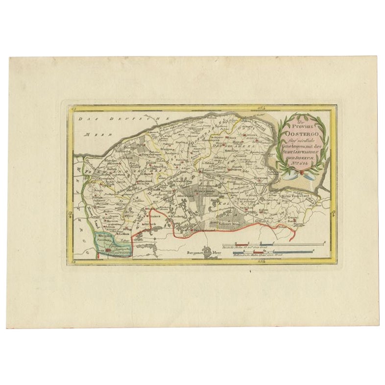
Antique Map of the Region of Leeuwarden and Dokkum in The Netherlands, 1791
Located in Langweer, NL
Antique map titled 'Der Provinz Oostergo fünf nördliche Grietenyen mit der Stadt Leeuwaarden und Dokkum'. Map of the region of Leeuwarden and Dokkum, Friesland, the Netherlands. This...
Category
Antique 18th Century Maps
Materials
Paper
$150 Sale Price
20% Off
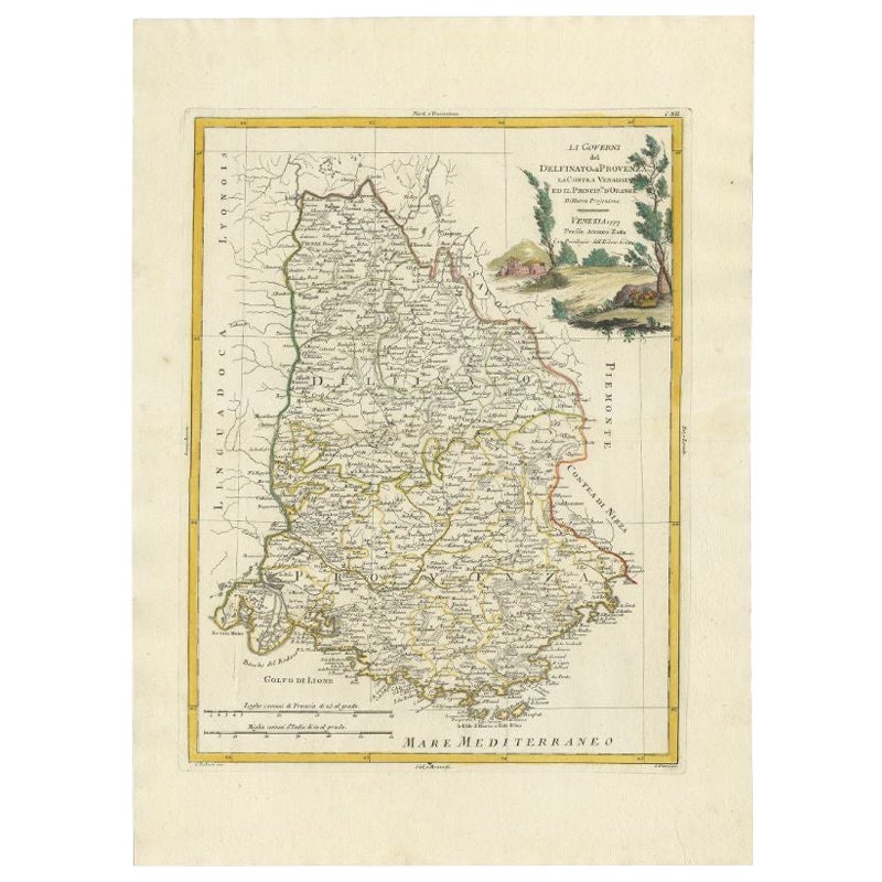
Antique Map of the Region of Dauphiné by Zatta, 1779
Located in Langweer, NL
Antique map titled 'Li Governi del Delfinato e di Provenza la Contea Venaissin ed il Princie d'Orange'. Old map of France showing the province of Dauphiné. This map originates from '...
Category
Antique 18th Century Maps
Materials
Paper
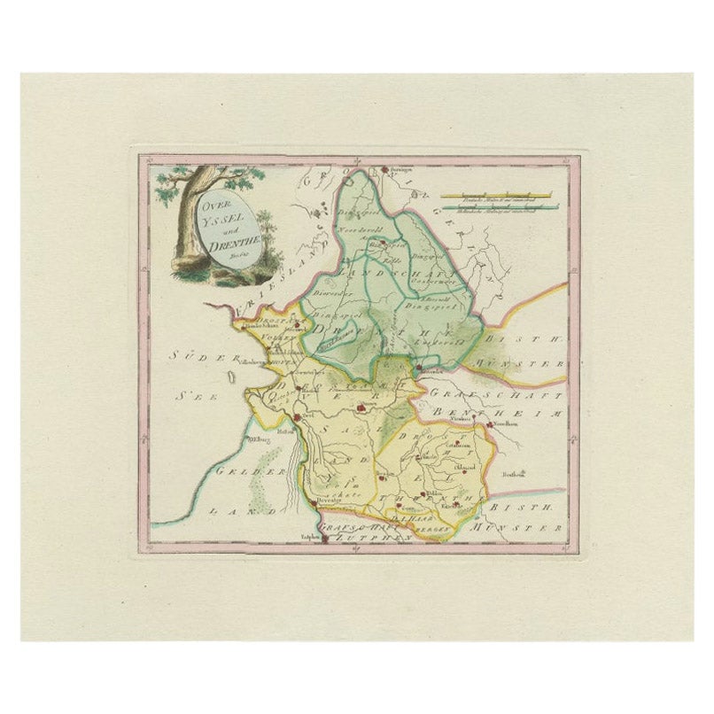
Antique Map of Overijssel and Drenthe by Von Reilly, c.1795
Located in Langweer, NL
Antique map titled 'Overyssel und Drenthe'. Decorative map of Overijssel and Drenthe, The Netherlands. This map originates from 'Schauplatz Der Funf Theile der Welt' (Wien: Reilly, 1...
Category
Antique 18th Century Maps
Materials
Paper
$148 Sale Price
20% Off
You May Also Like
1752 Vaugoundy Map of Flanders : Belgium, France, and the Netherlands, Ric.a002
Located in Norton, MA
Large Vaugoundy Map of Flanders:
Belgium, France, and the Netherlands
Colored -1752
Ric.a002
Description: This is a 1752 Didier Robert de Vaugondy map of Flanders. The map de...
Category
Antique 17th Century Unknown Maps
Materials
Paper

Map Southern Scotland Thomas Conder Alex Hogg 1795
Located in BUNGAY, SUFFOLK
A new map of the southern part of Scotland containing the counties of Stirling, Lanerk, Renfrew, Linlithgow, Edinburgh, Peebles, Haddingtoun, Berwick, Selkirk, Roxburgh, Dumfries, Wigtoun, Kirkudbright & Air
Published by Alex Hogg at the Kings Arms...
Category
Antique 18th Century English Georgian Maps
Materials
Paper

Original Antique Map of Ancient Greece- Boeotia, Thebes, 1787
Located in St Annes, Lancashire
Great map of Ancient Greece. Showing the region of Boeotia, including Thebes
Drawn by J.D. Barbie Du Bocage
Copper plate engraving by P.F T...
Category
Antique 1780s French Other Maps
Materials
Paper

Original Antique Map of Switzerland, Engraved By Barlow, Dated 1807
Located in St Annes, Lancashire
Great map of Switzerland
Copper-plate engraving by Barlow
Published by Brightly & Kinnersly, Bungay, Suffolk.
Dated 1807
Unframed.
Category
Antique Early 1800s English Maps
Materials
Paper

Li Governi di Borgogna - Ancient Map - 1777
Located in Roma, IT
Li Governi di Borgogna is an original black and white etching on paper, printed by Antonio Zatta in Venice, 1777.
Original Title: Li Governi di Borgogna della Franca Contea e del Ly...
Category
1770s Modern Landscape Prints
Materials
Etching

1790 Thomas Stackhouse Map, Entitled "Russia in Europe, " , Ric.a004
Located in Norton, MA
1790 Thomas Stackhouse map, entitled
"Russia in Europe"
Ric.a004
Stackhouse, Thomas
Russia in Europe [map]
London: T. Stackhouse, 1783. Map. Matted hand-colored copper engraving. Image size: 14.5 x 15.25 inches. Mat size: 22.75 x 23.75 inches. A beautiful example of this map of Eastern Europe...
Category
Antique 17th Century Unknown Maps
Materials
Paper

More Ways To Browse
Franz Joseph
Ancient World Map
Antique Florida Map
Antique Geological Maps
Antique Map Chile
Antique Map Of Georgia
Antique Mississippi Furniture
Burgundy Map
Peninsular War
Taiwan Map
Used Furniture Alabama
Antique Chicago Maps
Dutch Bible
Thailand Map
Antique Dutch Bible
Antique Louisiana Map
Antique Maps Of Sicily
Patagonia Map