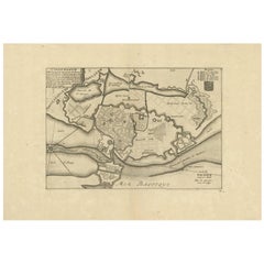
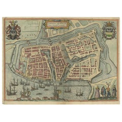
Antique Town Plan of Copenhagen 'Denmark' by P. Mortier, circa 1702
View Similar Items


Want more images or videos?
Request additional images or videos from the seller
1 of 8
Auction endedBrowse Current Auctions
Antique Town Plan of Copenhagen 'Denmark' by P. Mortier, circa 1702
About the Item
- Dimensions:Height: 12.8 in (32.5 cm)Width: 18.51 in (47 cm)Depth: 0.02 in (0.5 mm)
- Materials and Techniques:
- Period:
- Date of Manufacture:circa 1702
- Condition:Great condition. Please study image carefully.
- Seller Location:Langweer, NL
- Reference Number:Seller: BG-065191stDibs: LU305439798881
About the Seller
5.0
Platinum Seller
These expertly vetted sellers are 1stDibs' most experienced sellers and are rated highest by our customers.
Established in 2009
1stDibs seller since 2017
1,940 sales on 1stDibs
More From This SellerView All
- Antique Bible Plan of Jerusalem by Covens & Mortier, 1743Located in Langweer, NLThis plan originates from ‘Biblia Sacra, dat is, de H. Schriftuer van het Oude, en het Nieuwe Testament, naer de laetste Roomsche keure der gemeine Latijnsche overzettinge, in nederd...Category
Antique Mid-18th Century Maps
MaterialsPaper
 $393 Sale Price34% Off
 - Antique Map of Denmark by Covens & Mortier, 1730By Covens & MortierLocated in Langweer, NLAntique Map of Denmark from: 'Atlas Nouveau ... Par Guillaume de l'Isle' Amsterdam, Covens & Mortier, 1730.Category
Antique Mid-18th Century Maps
MaterialsPaper
 $389 Sale Price40% Off
 - Antique Town Plan of Emden ‘Germany’ by Braun & Hogenberg, 1597Located in Langweer, NLAntique map titled 'Embdena (..)'. Old, antique bird's-eye view plan of Emden, Germany. This bird's-eye view from the southwest over the Dollart shows Emden, which developed from a trading settlement in the 7th/8th centuries into a city as late as late 14th century. In 1494 it was granted staple rights, and in 1536 the harbour was extended. In the mid-16th century Emden's port was thought to have the most ships in Europe. Its population then was about 5,000, rising to 15,000 by the end of the 16th century. The Ems flowed directly under the city walls, but its course was changed in the 17th century by the construction of a canal. Emden has canals within its city limits, a typical feature of Dutch towns, which also enabled the extension of the harbour. Emden's first herring company was founded in 1553, and in 1595 Emden was created a Free Imperial City under the protection of Holland. Published by Braun...Category
Antique 16th Century Maps
MaterialsPaper
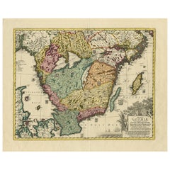
- Antique Map of Southern Sweden by Covens & Mortier, 'circa 1720'Located in Langweer, NLAntique map titled 'Regni Gothiae (..)'. Detailed map of South Sweden. Embellished with beautiful title cartouche with scale and coats of arms. Published in Amsterdam by Covens & Mor...Category
Antique Early 18th Century Maps
MaterialsPaper
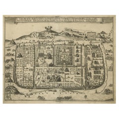
- Spectacular Antique Original Engraving of a Town Plan of Jerusalem, 1708Located in Langweer, NLDescription: Antique map titled 'Erster Abriss der Stadt Jerusalem wie sie Furnemblich zur Zeit des Hernn Christi beschaffen (..).' Spectacular town plan...Category
Antique Early 1700s Maps
MaterialsPaper
 $1,187 Sale Price20% Off
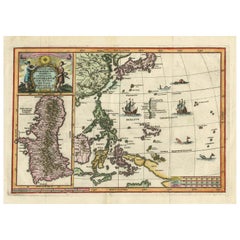
 - Antique Map of the Philippines and Guam by Scherer, circa 1702Located in Langweer, NLAntique map titled 'Nova et Vera Exhibitio Geographica Insularum Marianarum (..)'. Rare and very attractive map of the Mariana Islands, Philippines, Ko...Category
Antique Early 18th Century Maps
MaterialsPaper
 $1,855 Sale Price24% Off
You May Also Like
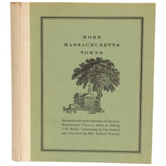
- More Massachusetts Towns, Illustrated with Wood Engravings of 53 Mass. TownsLocated in valatie, NYMore Massachusetts Towns, illustrated with wood engravings of fifty-three Massachusetts Towns, drawn in 1840 by J. W. Barber. Commentary by Ivan Sandrof, and a special foreword by Mr...Category
Vintage 1960s American Books
MaterialsPaper
- Catalogue of Engraved Views, Plans, Etc., Of New York City, 1st EdLocated in valatie, NYA catalogue of engraved views, plans, etc., Of New York City, (The Collection of Percy R. Pyne II). Privately Printed by The De Vinne Press, New York, 1912. Limited to 100 copies. Gr...Category
Early 20th Century American Books
MaterialsPaper
- Civil War Panorama of the Seat of War by John Bachmann, Antique Print circa 1864Located in Colorado Springs, COPanorama of the seat of war. Bird's-eye View of Virginia, Maryland, Delaware and the District of Columbia. This third state of this fascinating bird's eye view of the northernmost p...Category
Antique 1860s American Maps
MaterialsPaper
- George Washington by Henry Sadd, Antique Engraving, circa 1844Located in Colorado Springs, COThis is an 1844 engraving of President George Washington. The print was issued by G. Stuart in Albion, New York and engraved by H. S. Sadd. This standing portrait shows President George Washington in front of neoclassical columns. In his right hand, he holds a dress sword...Category
Antique 1840s American Prints
MaterialsPaper
- Antique Map of Italy by Andriveau-Goujon, 1843By Andriveau-GoujonLocated in New York, NYAntique Map of Italy by Andriveau-Goujon, 1843. Map of Italy in two parts by Andriveau-Goujon for the Library of Prince Carini at Palazzo Carini i...Category
Antique 1840s French Maps
MaterialsLinen, Paper
 $3,350 / set
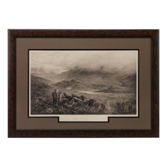
 - "Rough Shooting" First Edition Antique Engraving by Douglas Adams, circa 1893By Douglas AdamsLocated in Colorado Springs, COThis is a first edition print of Rough Shooting, signed by the artist, Douglas Adams. The print was published by Thomas McLean and depicts a highlands s...Category
Antique 1890s British Prints
MaterialsPaper


Recently Viewed
View AllMore Ways To Browse
Antique Map Denmark
Copenhagen Map
Denmark Print Map
Danish Prints 18th Century
Antique Map Copenhagen
George Fleet
Antique Railroad Maps
Map Of New Zealand
Antique Map Art Collectibles
Antique Maps Art Collectibles
James Cook Map
Nautical Charts
Old Antique Compass
Map New Holland
World Maps Antique Style
World Map Antique Style
Antique Style Map Of The World
Map Sweden