
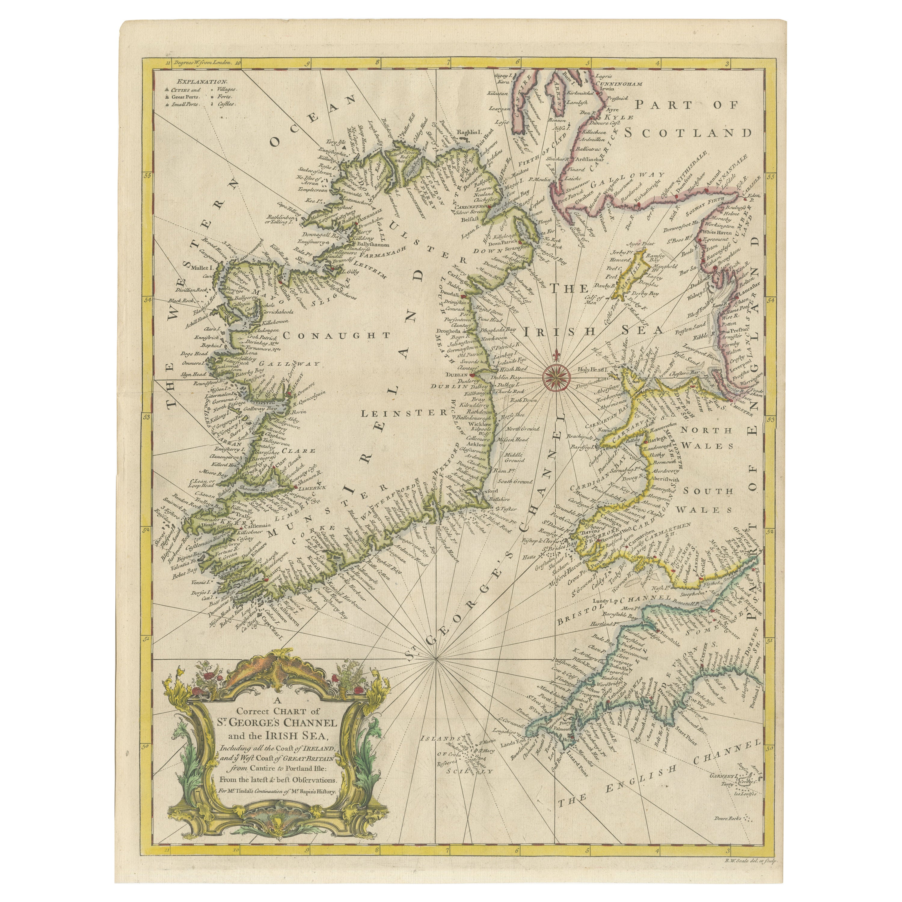
Dartmouth, England: A Hand-Colored 17th Century Sea Chart by Captain Collins
View Similar Items


1 of 7
Dartmouth, England: A Hand-Colored 17th Century Sea Chart by Captain Collins
$2,775List Price
About the Item
- Creator:Captain Greenvile Collins (Artist)
- Dimensions:Height: 23 in (58.42 cm)Width: 27.75 in (70.49 cm)Depth: 0.5 in (1.27 cm)
- Materials and Techniques:Paper,Engraved
- Place of Origin:
- Period:Late 17th Century
- Date of Manufacture:1693
- Condition:Wear consistent with age and use.
- Seller Location:Alamo, CA
- Reference Number:Seller: # 32471stDibs: LU5206220491632
Authenticity Guarantee
In the unlikely event there’s an issue with an item’s authenticity, contact us within 1 year for a full refund. DetailsMoney-Back Guarantee
If your item is not as described, is damaged in transit, or does not arrive, contact us within 7 days for a full refund. Details24-Hour Cancellation
You have a 24-hour grace period in which to reconsider your purchase, with no questions asked.Vetted Professional Sellers
Our world-class sellers must adhere to strict standards for service and quality, maintaining the integrity of our listings.Price-Match Guarantee
If you find that a seller listed the same item for a lower price elsewhere, we’ll match it.Trusted Global Delivery
Our best-in-class carrier network provides specialized shipping options worldwide, including custom delivery.You May Also Like
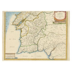
17th Century Map of Southern Portugal by Sanson – Hand-Colored, 1679
Located in Langweer, NL
17th Century Map of Southern Portugal by Sanson – Hand-Colored, 1679
This stunning 1679 map of Portugal offers a captivating glimpse into the past, showcasing the country's geograph...
Category
Antique Late 17th Century French Maps
Materials
Paper
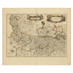
Picardy Map - Hand-Colored 17th-Century Engraving by Frederik De Wit c. 1688
Located in Langweer, NL
Title: Picardy Map - Hand-Colored 17th-Century Engraving by Frederik De Wit c. 1688
Description: This beautifully detailed map, "Nova Picardiae Tabula," captures the Picardy region ...
Category
Antique 1680s Maps
Materials
Paper
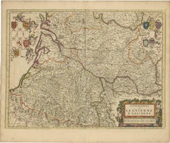
Gascogne and Guyenne Map - Hand-Colored 17th-Century Engraving by De Wit, c.1688
Located in Langweer, NL
Title: Gascogne and Guyenne Map - Hand-Colored 17th-Century Engraving by Frederik De Wit c. 1688
Description: This remarkable map, "Gouvernement de la Guyenne & Gascogne," captures ...
Category
Antique 1680s Maps
Materials
Paper
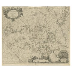
17th Century Nautical Chart of Skagerrak and Øresund by Johannes van Keulen
Located in Langweer, NL
This map titled *Pascaret van Schager-Rack de Bælt en de Sondt* was created by the prominent Dutch cartographer Johannes van Keulen and published in Amsterd...
Category
Antique Late 17th Century Maps
Materials
Paper
$912 Sale Price
20% Off
Hand-Colored 17th-Century Map of Orléanais in France by Frederik De Wit c. 1688
Located in Langweer, NL
Title: Hand-Colored 17th-Century Map of Orléanais by Frederik De Wit c. 1688
Description: This beautifully crafted map, "Gouvernement General du Pays Orléanois," illustrates the Orl...
Category
Antique 1680s Maps
Materials
Paper

Tripod Apothecary Skillet Late 17th-Early 18th Century, England
Located in Brussels, Brussels
Apothecary tripod skillet from the end of the 17th century beginning of the 18th century From England.
The skillet is in superb condition and has not undergone any restorations.
Br...
Category
Antique Early 18th Century British Georgian Decorative Bowls
Materials
Bronze

Recently Viewed
View AllMore Ways To Browse
Charles I Of England
Sea Captain
Map Of Great Britain
Sea Captains Furniture
Antique Maltese Furniture
Tom Collins
Antique Maps Of Malta
Maltese Falcon
Antique Compass Map
Blaeu Maps
Antique Collectables Australia
Military Map
Antique Maps Scotland
Mississippi Antique
Denmark Map
Antique Maps Of North America
Wine Map
Map Greece