Items Similar to Empire's Tapestry: Mapping Portugal's Global Legacy in 1903


Want more images or videos?
Request additional images or videos from the seller
1 of 10
Empire's Tapestry: Mapping Portugal's Global Legacy in 1903
$326.38
$407.9820% Off
£240.69
£300.8720% Off
€272
€34020% Off
CA$450.73
CA$563.4120% Off
A$494.56
A$618.2020% Off
CHF 258.83
CHF 323.5420% Off
MX$6,086.34
MX$7,607.9320% Off
NOK 3,260.86
NOK 4,076.0720% Off
SEK 3,054.28
SEK 3,817.8520% Off
DKK 2,071.61
DKK 2,589.5220% Off
About the Item
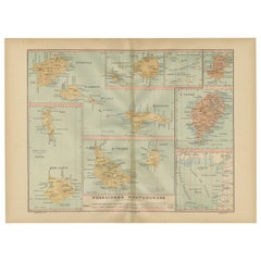
This map is an original antique map that showcases Portuguese possessions around the turn of the 20th century, with a focus on Guinea-Bissau (referred to on the map as "Guiné Portuguesa"), as well as insets of other colonial territories including Goa (in India), Damão (Daman), Diu, Macau (in China), and Timor (split between present-day Indonesia and East Timor).
Each map segment provides a detailed view of the respective territory's geography, including major towns, rivers, and the transportation networks of that era. These regions are historically significant for various reasons:
- **Guinea-Bissau**: Known for its rich cultural heritage and as an important center of the transatlantic slave trade.
- **Goa, Daman, and Diu**: These were key trading ports on the west coast of India with a significant influence on the cultural and culinary landscapes of the region.
- **Macau**: It served as a major gateway for the exchange between Chinese and European cultures and was one of the oldest European colonies in Asia.
- **Timor**: This island was split into western and eastern parts, with the eastern part being the Portuguese colony. It has a unique history and blend of cultures due to its colonial past.
- Dimensions:Height: 20.08 in (51 cm)Width: 14.77 in (37.5 cm)Depth: 0 in (0.02 mm)
- Materials and Techniques:
- Period:1900-1909
- Date of Manufacture:1903
- Condition:Good condition. Central vertical folding lines as issued. Aged paper with typically warm, yellowish-brown hue, especially around the edges and folding lines, adding to its patina. Check the images carefully.
- Seller Location:Langweer, NL
- Reference Number:Seller: BG-13642-581stDibs: LU3054338034742
About the Seller
5.0
Recognized Seller
These prestigious sellers are industry leaders and represent the highest echelon for item quality and design.
Platinum Seller
Premium sellers with a 4.7+ rating and 24-hour response times
Established in 2009
1stDibs seller since 2017
2,618 sales on 1stDibs
Typical response time: <1 hour
- ShippingRetrieving quote...Shipping from: Langweer, Netherlands
- Return Policy
Authenticity Guarantee
In the unlikely event there’s an issue with an item’s authenticity, contact us within 1 year for a full refund. DetailsMoney-Back Guarantee
If your item is not as described, is damaged in transit, or does not arrive, contact us within 7 days for a full refund. Details24-Hour Cancellation
You have a 24-hour grace period in which to reconsider your purchase, with no questions asked.Vetted Professional Sellers
Our world-class sellers must adhere to strict standards for service and quality, maintaining the integrity of our listings.Price-Match Guarantee
If you find that a seller listed the same item for a lower price elsewhere, we’ll match it.Trusted Global Delivery
Our best-in-class carrier network provides specialized shipping options worldwide, including custom delivery.More From This Seller
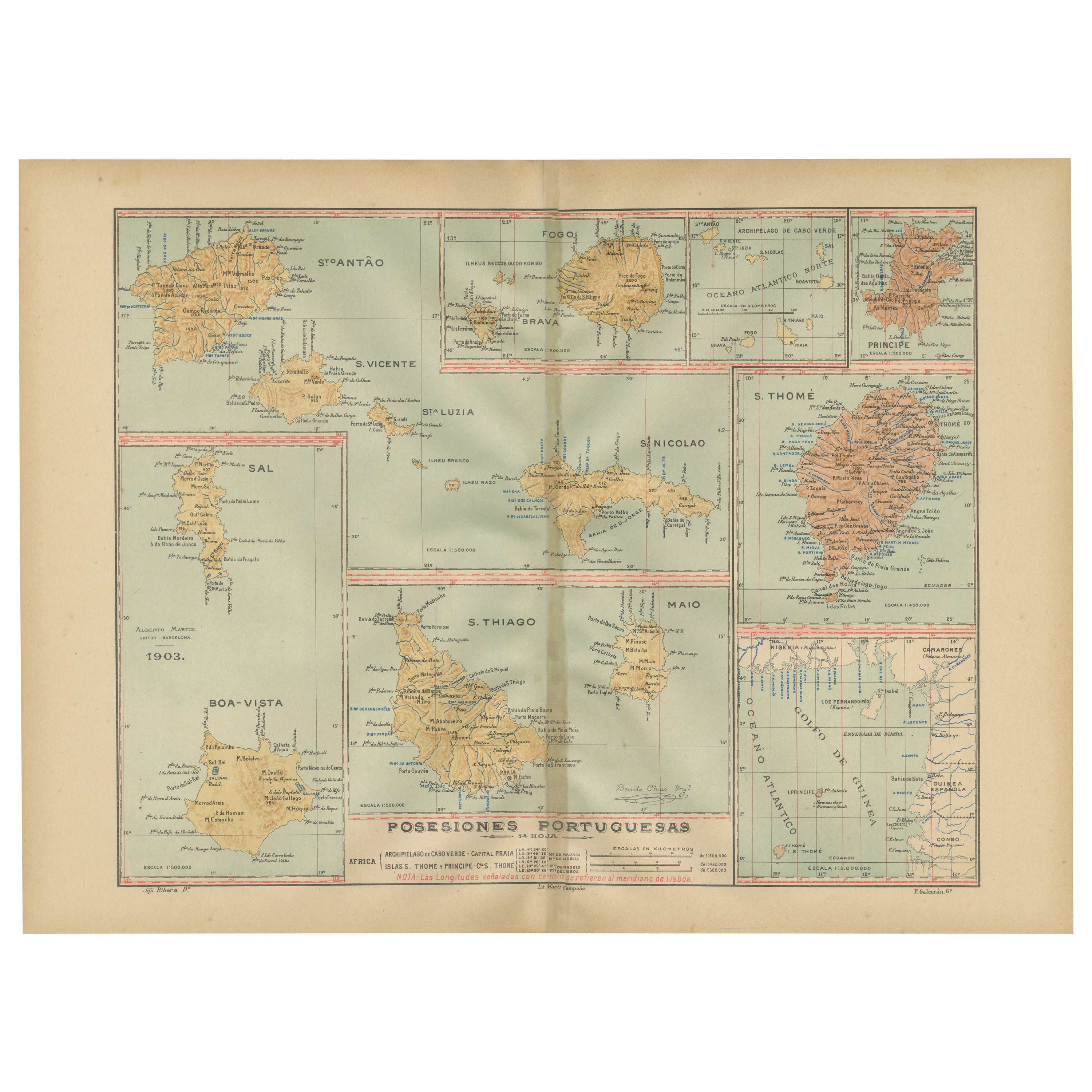
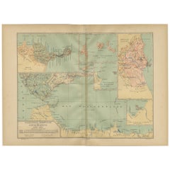
View AllIslands of Diversity: Portugal's Atlantic Archipelagos in 1903
Located in Langweer, NL
The image is an original historical map from 1903 depicting Portuguese possessions in the Atlantic Ocean, specifically the islands of Cape Verde and the islands of São Tomé and Prínc...
Category
Antique Early 1900s Maps
Materials
Paper
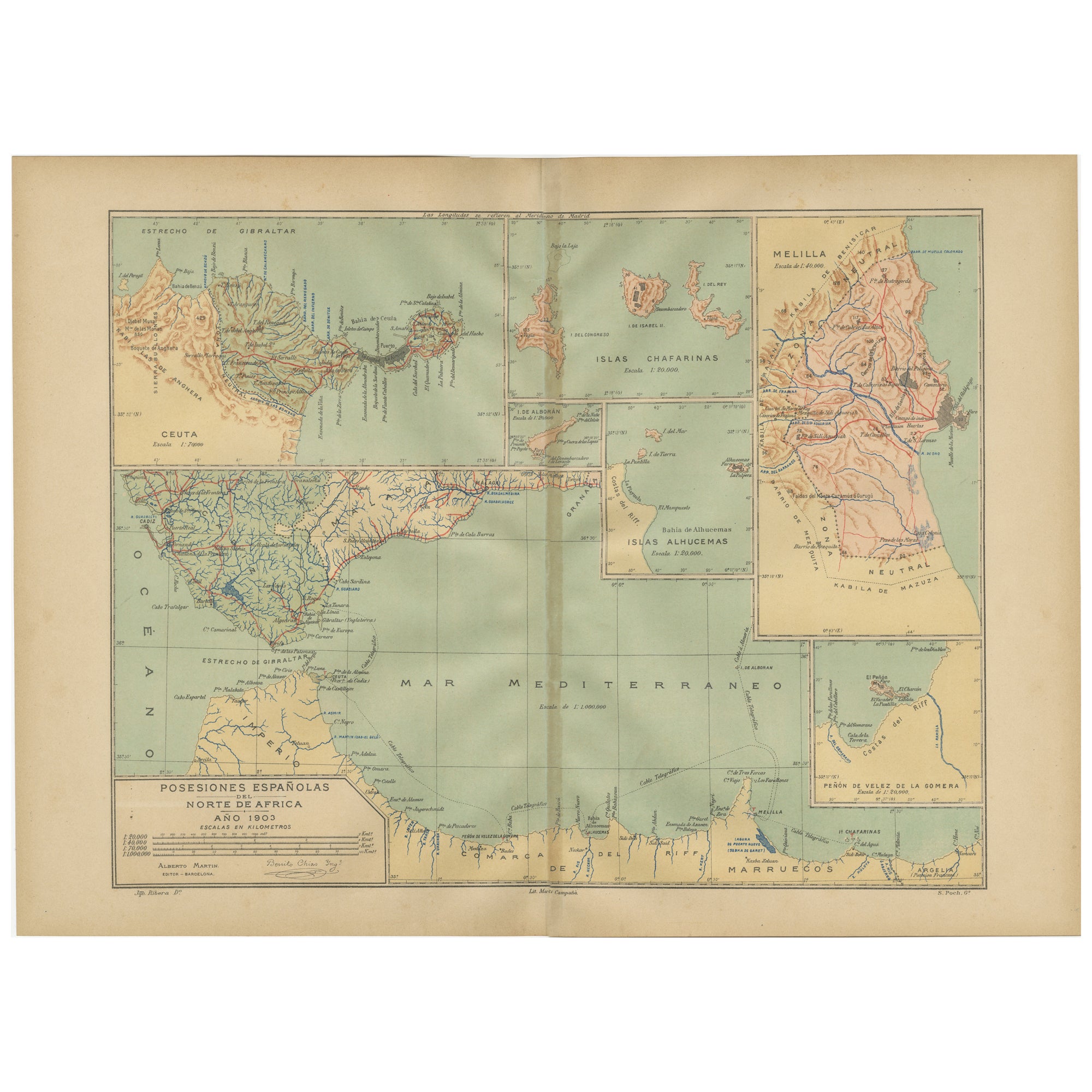
Crossroads of Continents: Spain's North African Enclaves in 1903
Located in Langweer, NL
The image for sale is a historical map of Spanish possessions in North Africa, dated 1903. The map includes the enclaves of Ceuta and Melilla, the Chafarinas Islands, the Alhucemas I...
Category
Antique Early 1900s Maps
Materials
Paper
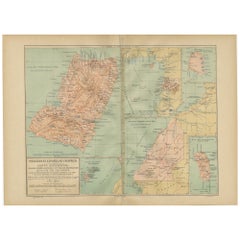
Echoes of Empire: Spanish Territories in West Africa, 1903
Located in Langweer, NL
This is a historical map showing Spanish possessions in West Africa from the year 1903. The map includes the islands of Fernando Póo (now known as Bioko), part of the modern-day country of Equatorial Guinea, Annobón Island, and the Elobey Islands, along with the Spanish-controlled areas on the continental region near Rio Muni.
These territories were part of Spain's colonial empire and are situated in the Gulf of Guinea, off the coast of Central Africa. Fernando Póo (Bioko) is particularly notable for its volcanic origins and as a center of cocoa production during the colonial period. Annobón, lying further southwest of Bioko, is a small volcanic island. The Elobey Islands are very small and located near the coast of Gabon.
Here's a brief overview of their significance:
1. **Bioko Island (Fernando Póo)**: The island has a rich biodiversity and is known for its unique flora and fauna, including several endemic species. Malabo, the capital city of Equatorial Guinea, is located here.
2. **Annobón Island**: This remote island has a small population and is known for its isolation and distinctive Creole culture, which has developed independently from the mainland.
3. **Elobey Islands**: These consist of Elobey Grande and Elobey Chico and are situated near the mouths of the Muni and Campo rivers. They were historically important as transit points in river trade...
Category
Antique Early 1900s Maps
Materials
Paper
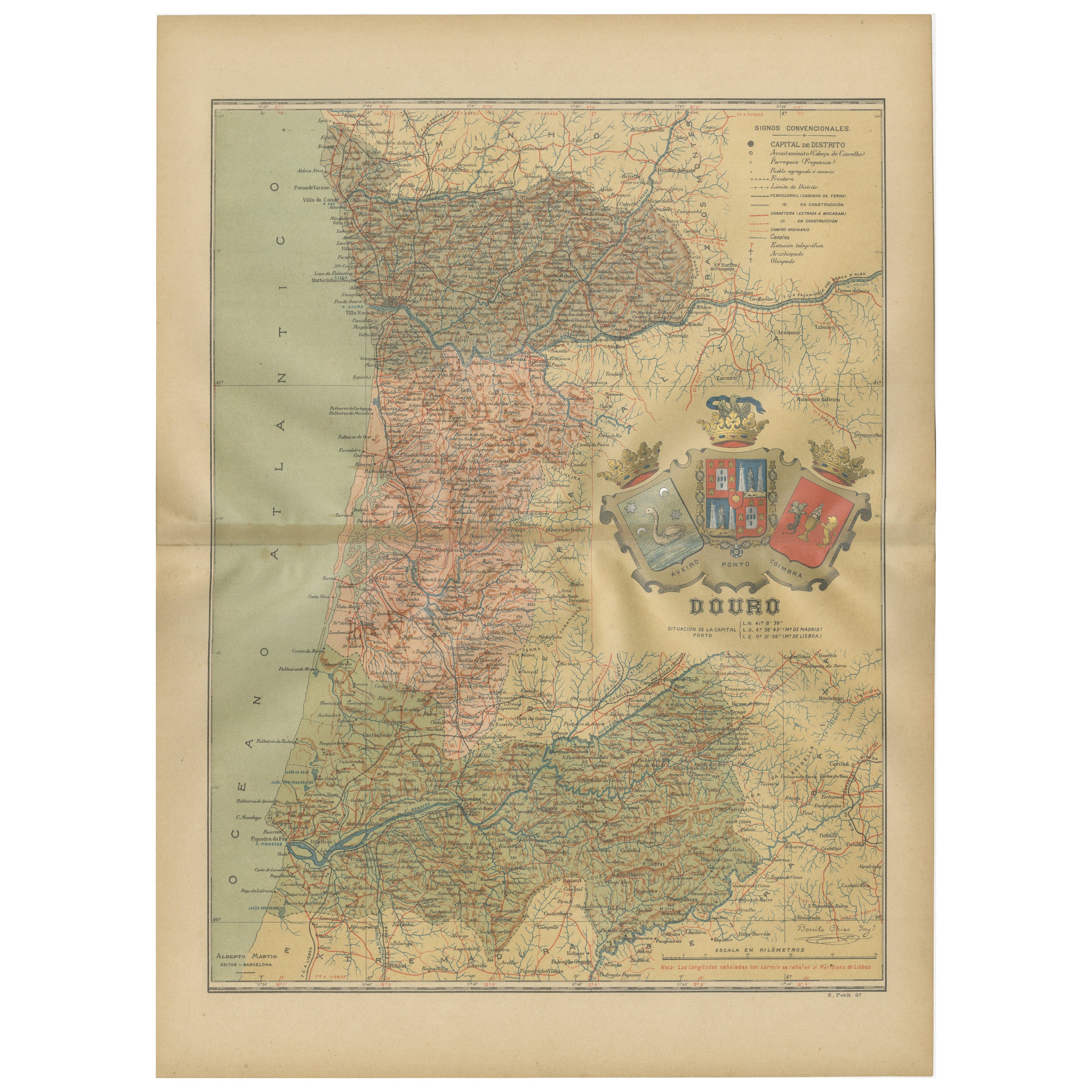
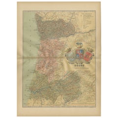
Douro: The River of Tradition and Wine in Portugal, 1903
Located in Langweer, NL
The uploaded image is a historical map of the Beira Baixa region in Portugal. The map details the topography, including mountain ranges and river systems, as well as the transportati...
Category
Antique Early 1900s Maps
Materials
Paper
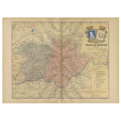
Trás-os-Montes: A Cartographic Exploration of Portugal's Hidden Province in 1903
Located in Langweer, NL
This print is an original historical map of the Trás-os-Montes region in the northeastern part of Portugal, dated 1903. Trás-os-Montes is often translated as "behind the mountains," ...
Category
Antique Early 1900s Maps
Materials
Paper
$297 Sale Price
20% Off
Free Shipping
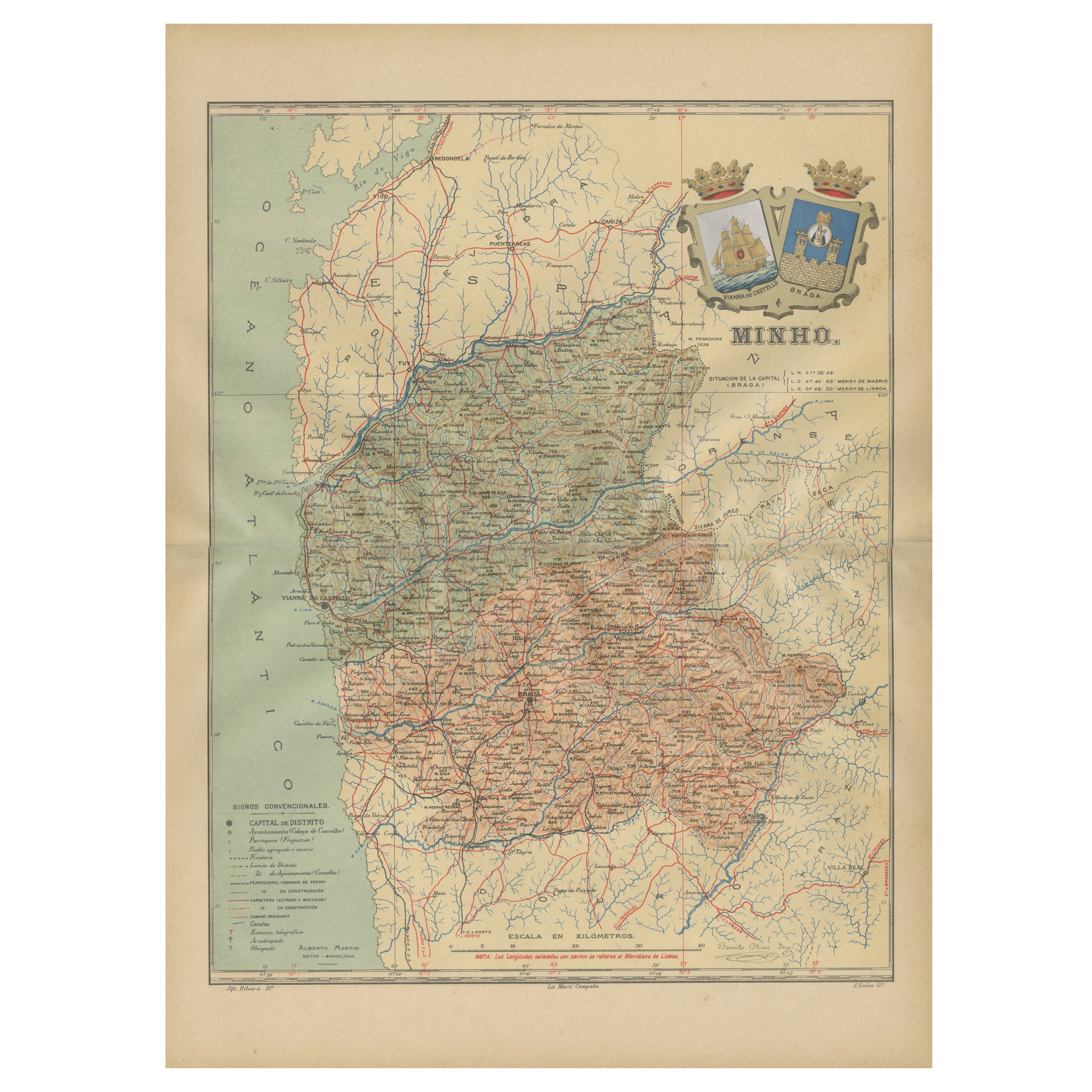
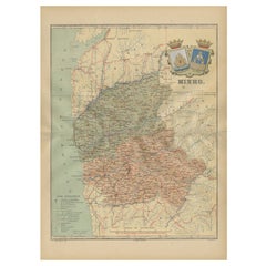
Minho: A Legacy of Lush Landscapes and Living Traditions in Portugal, 1903
Located in Langweer, NL
Ths authentic print is a historical map of the Minho region in the northwestern part of Portugal. The map includes detailed geographical features, such as rivers, mountain ranges, an...
Category
Antique Early 1900s Maps
Materials
Paper
$326 Sale Price
20% Off
Free Shipping
You May Also Like
Geographical Antique Map of Principality of Monaco
By Bruno Santini
Located in Alessandria, Piemonte
ST/609 - Interesting antique color map of Monaco Principality in French language : "Carte qui contient le Principauté de Piémont, le Monferrat et la comté de...
Category
Antique Late 18th Century Italian Other Maps
Materials
Paper

Ancient National Atlas of France with Marengo
Located in Alessandria, Piemonte
Ancient National Atlas of France with the department of Marengo: a rare French etching dated 1806.
ST/178.
Category
Antique Early 19th Century French Other Prints
Materials
Paper

Map Huntingdonshire R Scott Archibald Fullarton & Co Glasgow
Located in BUNGAY, SUFFOLK
Folding Map of Huntingdonshire by R Scott with distances from London and reference to the hundreds.
Published by Archibald Fullarton & Co Glasgow. Measure: 40...
Category
Antique 19th Century English Victorian Maps
Materials
Paper

Antique 1803 Italian Map of Asia Including China Indoneseia India
Located in Amsterdam, Noord Holland
Antique 1803 Italian Map of Asia Including China Indoneseia India
Very nice map of Asia. 1803.
Additional information:
Type: Map
Country of Manufacturing: Europe
Period: 19th centu...
Category
Antique 19th Century European Maps
Materials
Paper

$584 Sale Price
20% Off
Original 1891 Walker Map
Located in Norwell, MA
Original 1891 map of Massachusetts by Walker. Towns include Cambridge, Boston, Dedham, Ashland, Brookline, Newton etc... burl wood frame. Measures...
Category
Antique 19th Century Maps

South America, Eastern Part. Century Atlas antique vintage map
Located in Melbourne, Victoria
'The Century Atlas. South America. Eastern Part'
Original antique map, 1903.
Inset map 'Rio de Janeiro and Vicinity'.
Central fold as issued. Map name and number printed on the rev...
Category
Early 20th Century Victorian More Prints
Materials
Lithograph

More Ways To Browse
Timor Indonesia
Tapestry Portugal
Guinea Bissau
1960s Glass Top Coffee Table
Black Glass Coffee Tables
Mid Century Modern Yellow Chair
18th Century Engravings
Midcentury Japanese Ceramics
Black Marble Table Vintage
Blue Green Wool And Silk Rug
Midcentury Modern Gray Glass Vase
Oak Side Table Drawer
Music Chair
Vintage 1930 Dining Room Set
50 X 50 Coffee Table
Antique Hand Carved Dining Room Sets
Interlocking Dining Table
Italy Table Mahogany