Items Similar to Géographie des Hébreux – Tableau de la Dispersion des Enfants de Noé, 1837


Video Loading
Want more images or videos?
Request additional images or videos from the seller
1 of 11
Géographie des Hébreux – Tableau de la Dispersion des Enfants de Noé, 1837
$229.05
$286.3120% Off
£169.32
£211.6520% Off
€192
€24020% Off
CA$317.70
CA$397.1320% Off
A$346.37
A$432.9620% Off
CHF 183.01
CHF 228.7720% Off
MX$4,259.48
MX$5,324.3520% Off
NOK 2,275.62
NOK 2,844.5220% Off
SEK 2,142.19
SEK 2,677.7420% Off
DKK 1,461.98
DKK 1,827.4820% Off
About the Item
Géographie des Hébreux – Tableau de la Dispersion des Enfants de Noé, 1837
This antique map, titled Géographie des Hébreux ou Tableau de la Dispersion des enfants de Noé, offers a fascinating insight into biblical geography as it was understood in the early 19th century. Published in 1837 by Félix Delamarche as part of his Atlas De La Géographie Ancienne, the map presents the postdiluvian world according to Hebrew traditions. It depicts the dispersion of the sons of Noah—Shem, Ham, and Japheth—and their descendants across Europe, Asia, and parts of Africa following the events of the Great Flood.
What makes this map particularly captivating is its unique blend of biblical interpretation and early modern cartography. The lands inhabited by various tribes and peoples are laid out with clarity, accompanied by an informative genealogical chart tracing the lineages of Noah’s descendants. Prominent biblical regions such as Canaan, Mesopotamia, Media, and Egypt are clearly marked, offering viewers a window into the worldview of 19th-century biblical scholars and geographers.
The cartouche is elegantly composed, and the typography is in the classical style typical of French cartography from this era. Delamarche, a notable French geographer and publisher, was known for reissuing and refining the works of earlier mapmakers, and this map is a fine example of his commitment to combining scientific precision with educational purpose.
This print is an excellent addition to any collection of biblical maps, Judaica, or 19th-century cartography, and serves as both an aesthetic and scholarly artifact.
Condition: Good condition overall. Fold as issued. Light general age-toning and a few small marginal stains, but the printed surface remains clean and well-preserved. Strong impression on robust paper.
Framing tips: A classic frame in dark wood or black complements the historical subject. Use a warm off-white or parchment-colored mount to highlight the paper tone. A gold-line inner mount can bring out the fine lettering and embellishments in the cartouche.
- Dimensions:Height: 13.12 in (33.3 cm)Width: 19.1 in (48.5 cm)Depth: 0.02 in (0.5 mm)
- Materials and Techniques:Paper,Engraved
- Place of Origin:
- Period:
- Date of Manufacture:1837
- Condition:Wear consistent with age and use. Good condition overall. Fold as issued. Light general age-toning and a few small marginal stains, but the printed surface remains clean and well-preserved. Strong impression on robust paper.
- Seller Location:Langweer, NL
- Reference Number:Seller: BG-094291stDibs: LU3054310070571
About the Seller
5.0
Recognized Seller
These prestigious sellers are industry leaders and represent the highest echelon for item quality and design.
Platinum Seller
Premium sellers with a 4.7+ rating and 24-hour response times
Established in 2009
1stDibs seller since 2017
2,620 sales on 1stDibs
Typical response time: <1 hour
- ShippingRetrieving quote...Shipping from: Langweer, Netherlands
- Return Policy
Authenticity Guarantee
In the unlikely event there’s an issue with an item’s authenticity, contact us within 1 year for a full refund. DetailsMoney-Back Guarantee
If your item is not as described, is damaged in transit, or does not arrive, contact us within 7 days for a full refund. Details24-Hour Cancellation
You have a 24-hour grace period in which to reconsider your purchase, with no questions asked.Vetted Professional Sellers
Our world-class sellers must adhere to strict standards for service and quality, maintaining the integrity of our listings.Price-Match Guarantee
If you find that a seller listed the same item for a lower price elsewhere, we’ll match it.Trusted Global Delivery
Our best-in-class carrier network provides specialized shipping options worldwide, including custom delivery.More From This Seller
View AllAntique Map of Northern Africa by Perthes, 1848
Located in Langweer, NL
Antique map titled 'Africa Propria (..)'. Old map of North Africa and the region of Babylon originating from 'Orbis Terrarum Antiquus in usum Scholarum'. Artists and Engravers: Publi...
Category
Antique 19th Century Maps
Materials
Paper

$94 Sale Price
20% Off
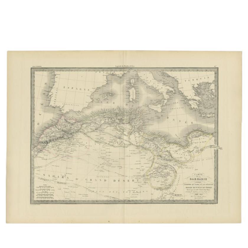
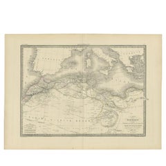
Antique Map of the Barbary Coast by Lapie, 1842
Located in Langweer, NL
Antique map titled 'Carte de la Barbarie contenant l'Empire de Maroc (..)'. Map of the Barbary Coast. This map originates from 'Atlas universel de géographie ancienne et moderne (..)...
Category
Antique 19th Century Maps
Materials
Paper
$232 Sale Price
20% Off
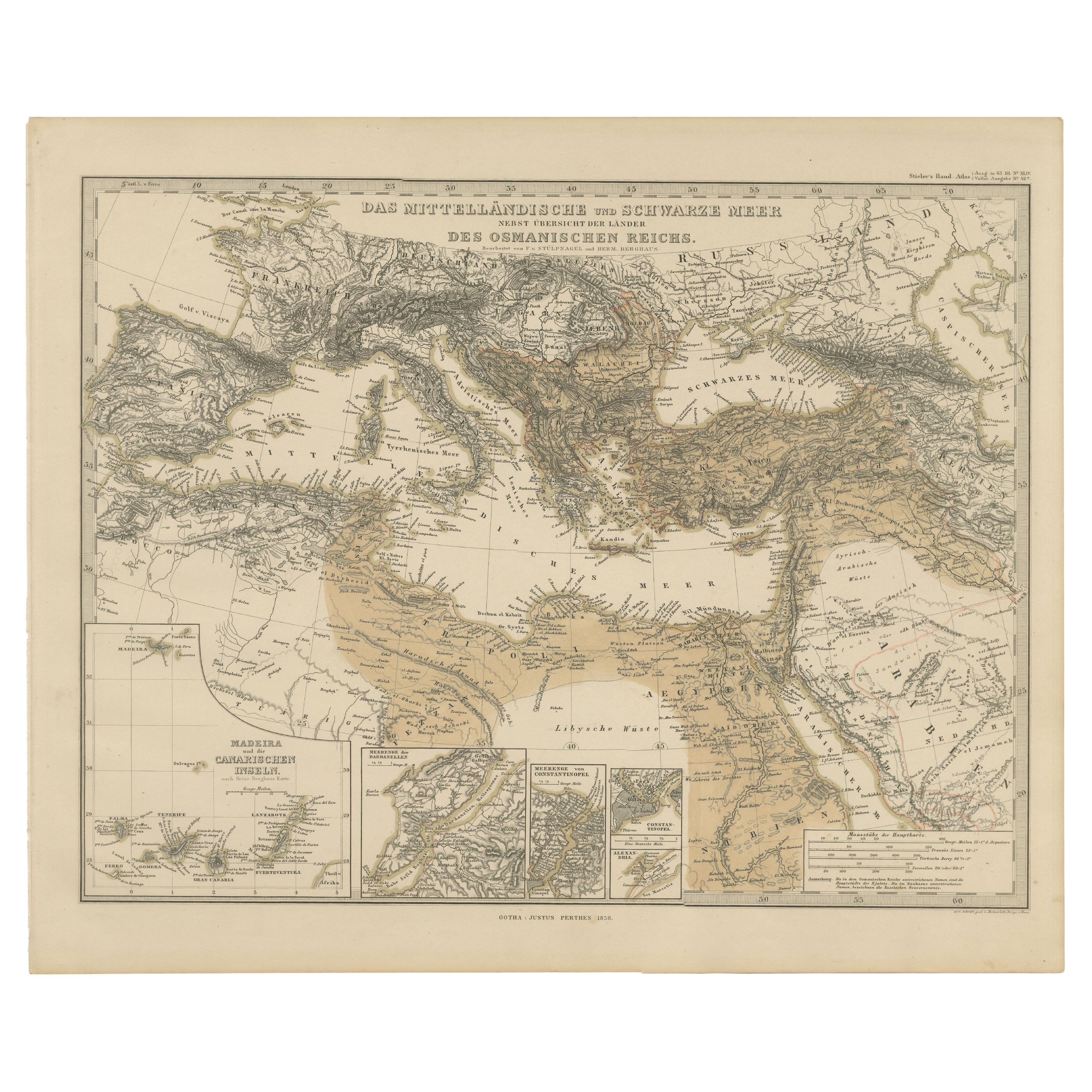
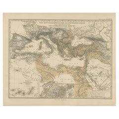
Mediterranean, Black Sea & Ottoman Empire Map 1853
Located in Langweer, NL
Mediterranean, Black Sea & Ottoman Empire Map 1853
This impressive antique print shows the Mediterranean and Black Sea regions with a focus on the Ottoman Empire, titled “Das Mittel...
Category
Antique Mid-19th Century German Maps
Materials
Paper
Antique Map of the Middle East by Perthes, 1848
Located in Langweer, NL
Antique map titled 'Terra inter Euphratem et Indum Antiqua'. Old map of the Middle East originating from 'Orbis Terrarum Antiquus in usum Schola...
Category
Antique 19th Century Maps
Materials
Paper

$94 Sale Price
20% Off
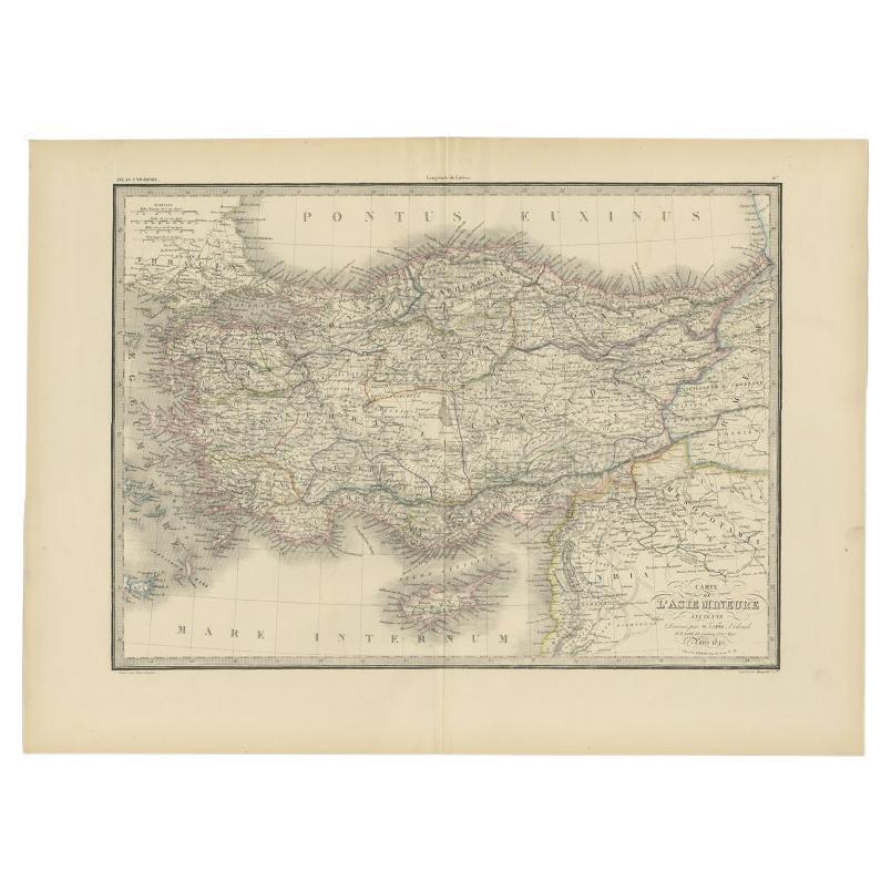
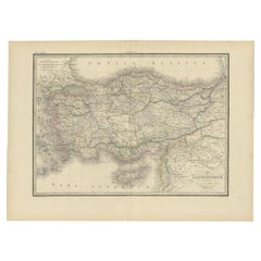
Antique Map of Asia Minor by Lapie, 1842
Located in Langweer, NL
Antique map titled 'Carte de l'Asie Mineure Ancienne (..)'. Map of Asia Minor, also called Anatolia or Turkish Anadolu. This map originates from 'Atlas univ...
Category
Antique 19th Century Maps
Materials
Paper
$372 Sale Price
20% Off
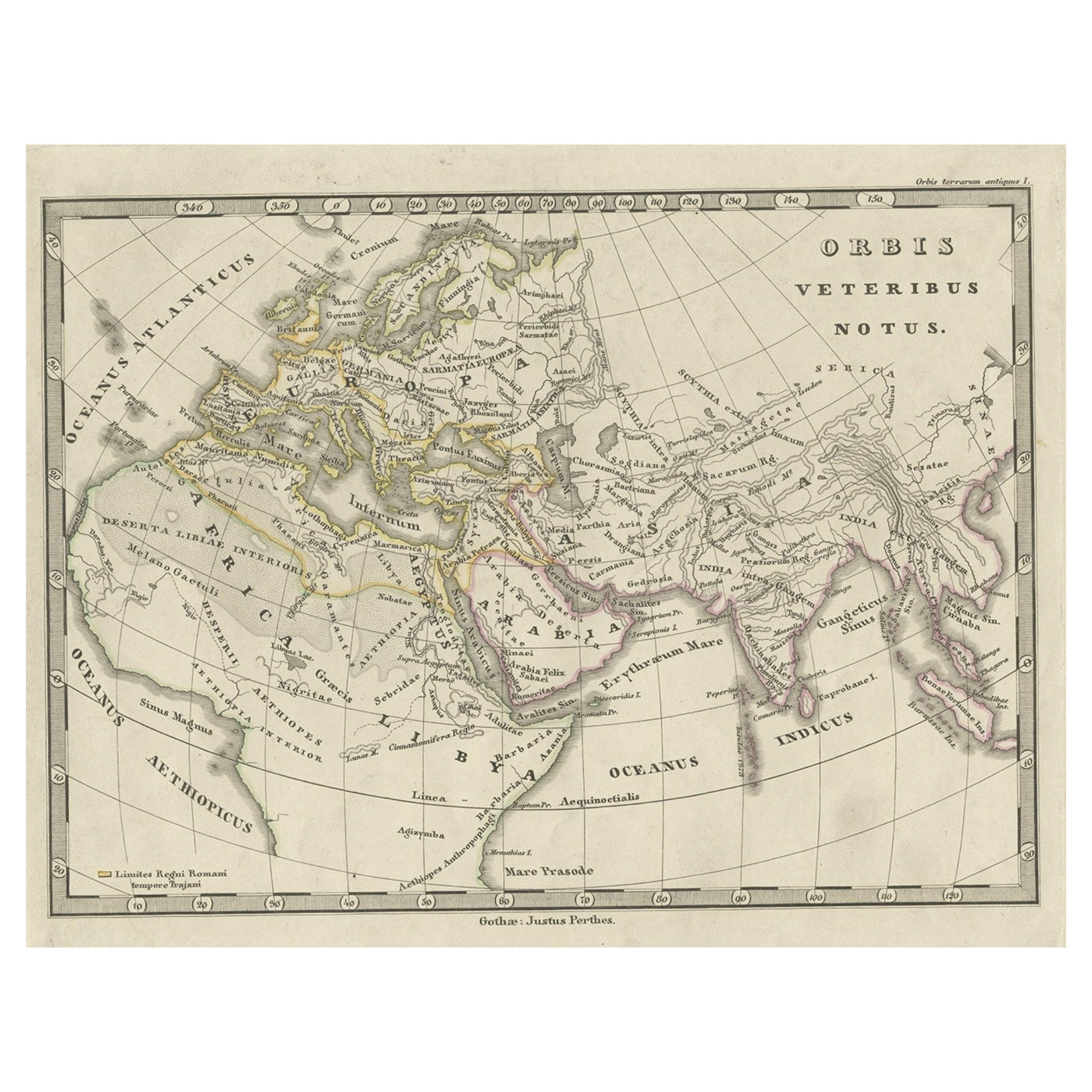
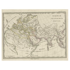
Antique Map of Europe and Part of Asia and Africa, 1848
Located in Langweer, NL
Antique map titled 'Orbis Veteribus Notus'. Old map of the European continent, also depicting a portion of Asia and Africa. Originating from 'Orbis Terrarum Antiquus in usum Scholaru...
Category
Antique 19th Century Maps
Materials
Paper
$94 Sale Price
20% Off
You May Also Like
Original Antique Map of Europe, Arrowsmith, 1820
Located in St Annes, Lancashire
Great map of Europe
Drawn under the direction of Arrowsmith.
Copper-plate engraving.
Published by Longman, Hurst, Rees, Orme and Brown, 1820
...
Category
Antique 1820s English Maps
Materials
Paper

Original Antique Map of The World by Thomas Clerk, 1817
Located in St Annes, Lancashire
Great map of The Eastern and Western Hemispheres
On 2 sheets
Copper-plate engraving
Drawn and engraved by Thomas Clerk, Edinburgh.
Published by Mackenzie And Dent, 1817
...
Category
Antique 1810s English Maps
Materials
Paper

Original Antique Map of The Eastern Hemisphere by Dower, circa 1835
Located in St Annes, Lancashire
Nice map of the Eastern Hemisphere
Drawn and engraved by J.Dower
Published by Orr & Smith. C.1835
Unframed.
Free shipping
Category
Antique 1830s English Maps
Materials
Paper

Original Antique Map of The World by Dower, circa 1835
Located in St Annes, Lancashire
Nice map of the World
Drawn and engraved by J.Dower
Published by Orr & Smith. C.1835
Unframed.
Free shipping
Category
Antique 1830s English Maps
Materials
Paper

Large Original Antique Map of South Italy and Malta by Sidney Hall, 1847
Located in St Annes, Lancashire
Great map of South Italy and Malta
Drawn by Sidney Hall
Steel engraving by G.Aikman
Original color outline
Published by A & C Black. 1847
Un...
Category
Antique 1840s Scottish Maps
Materials
Paper

Original Antique Map of Ancient Greece, Achaia, Corinth, 1786
Located in St Annes, Lancashire
Great map of Ancient Greece. Showing the region of Thessaly, including Mount Olympus
Drawn by J.D. Barbie Du Bocage
Copper plate engraving by P.F Tardieu
Original hand color...
Category
Antique 1780s French Other Maps
Materials
Paper

More Ways To Browse
Tableau Antique
19th Century Map Of Africa
19th Century Judaica
Biblical Maps
Illustrated Map
Antique World Maps
Antique Southern Furniture
Map Of Europe
Antique Maps Of Holland
Compass Rose Antique
Antique Furniture Portugal
Antique Maps Of Europe
Mexican Antiques
Map Of Africa
Mississippi Antique
Antique Furniture Plans
Ancient Collectibles
Antique Wood Coat Of Arms