Items Similar to Gipuzkoa 1902: A Cartographic Snapshot of the Basque Coastline and Highlands

Want more images or videos?
Request additional images or videos from the seller
1 of 7
Gipuzkoa 1902: A Cartographic Snapshot of the Basque Coastline and Highlands
About the Item
The map showcases the province of Gipuzkoa (also known as Guipúzcoa in Spanish), which is part of the autonomous community of the Basque Country in northern Spain, as of the year 1902. The map includes several notable features:
It depicts the mountainous terrain of the region, which is characteristic of the Basque Country, with detailed contour lines. There's a clear representation of the Cantabrian Sea coastline, including the rough coastal landscape for which the region is known. Blue lines likely represent the network of rivers that traverse the province, including the Urumea and Oria rivers. Red lines indicate roads and railways, outlining the transportation infrastructure critical for the region's connectivity. Various symbols are used to mark the locations of cities and towns, with the capital city, Donostia-San Sebastián, presumably indicated. Dotted lines suggest the administrative boundaries within the province. The map features a legend (Signos Convencionales) that explains the symbols used for provincial capitals, roads, railways, and other landmarks. A scale in kilometers at the bottom provides a reference for distance measurement.
The coat of arms of Gipuzkoa is prominently displayed, incorporating traditional heraldic imagery associated with the region's identity.
About the province of Gipuzkoa:
Gipuzkoa is one of the three provinces that make up the Basque Country, and it is known for its lush landscapes, coastal towns, and industrial heritage. The capital city, Donostia-San Sebastián, is famous for its beautiful bay of La Concha, vibrant cultural life, and its prestigious annual international film festival. The province has a strong industrial economy, with a history of steel manufacturing, and is also a leader in cooperative enterprises, most notably the Mondragon Corporation. The Basque culinary tradition is celebrated in Gipuzkoa, which boasts numerous high-quality restaurants, including several with Michelin stars. Traditional Basque sports, such as pelota and rural sports, are popular in the province. Gipuzkoa's unique cultural identity, language (Euskara), and traditions are a significant part of the region's allure.
- Dimensions:Height: 14.77 in (37.5 cm)Width: 20.08 in (51 cm)Depth: 0 in (0.02 mm)
- Materials and Techniques:
- Period:1900-1909
- Date of Manufacture:1902
- Condition:Good condition. Central vertical folding lines as issued. Aged paper with typically warm, yellowish-brown hue, especially around the edges. Some soiling on the borders and one small tear, not affecting the image. Check the images carefully.
- Seller Location:Langweer, NL
- Reference Number:
About the Seller
5.0
Platinum Seller
These expertly vetted sellers are 1stDibs' most experienced sellers and are rated highest by our customers.
Established in 2009
1stDibs seller since 2017
1,928 sales on 1stDibs
Typical response time: <1 hour
- ShippingRetrieving quote...Ships From: Langweer, Netherlands
- Return PolicyA return for this item may be initiated within 14 days of delivery.
More From This SellerView All
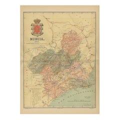
- 1902 Murcia: A Cartographic Snapshot of Spain's Southeastern ProvinceLocated in Langweer, NLThe map represents the province of Murcia, Spain, as it was in 1902. Here's an overview of its characteristics: - **Geography**: It displays the varied terrain of Murcia, from the c...Category
Antique Early 1900s Maps
MaterialsPaper
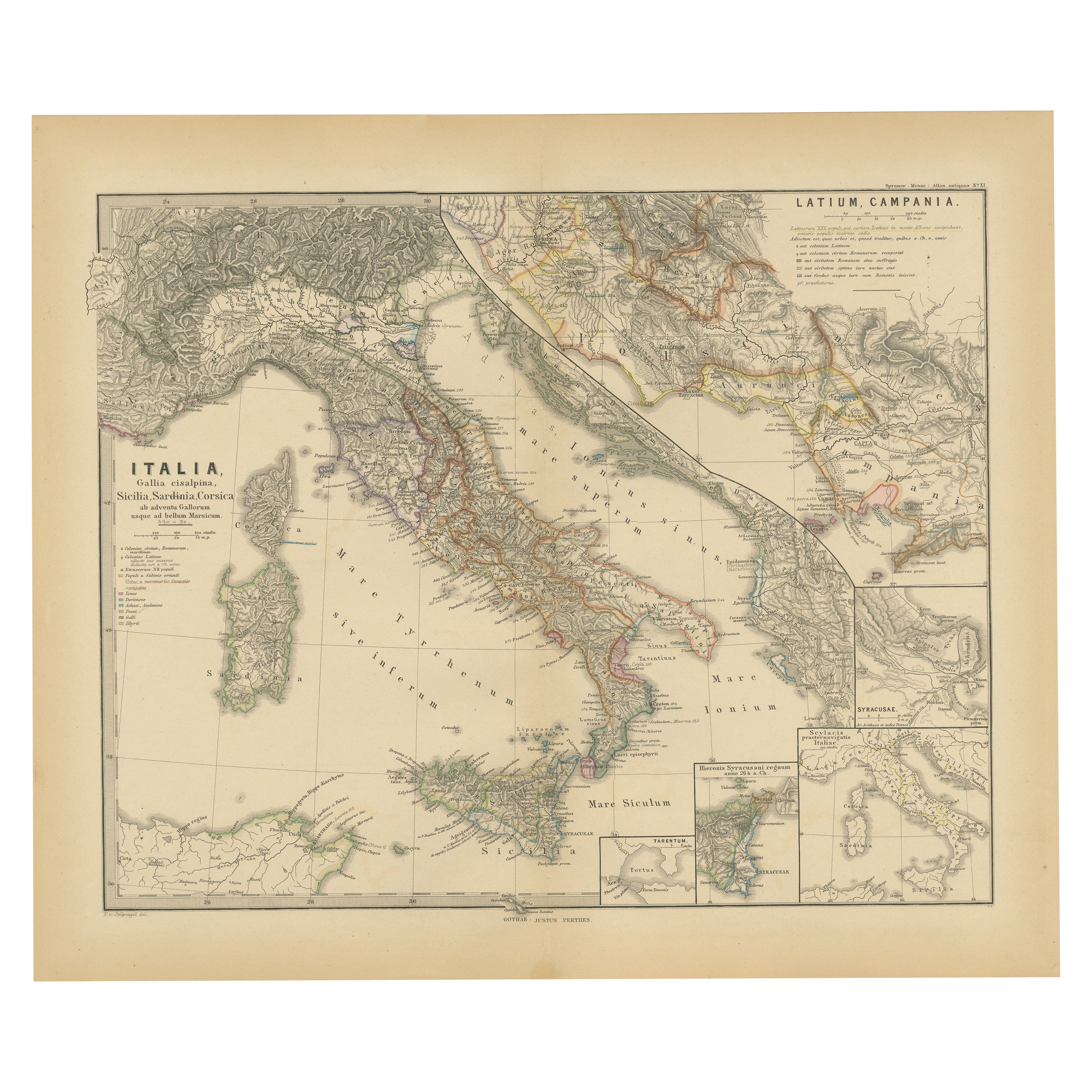
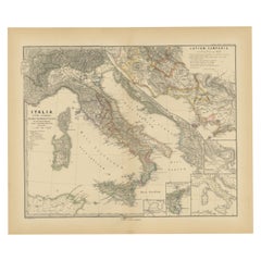
- Roman Italy and Provinces: A Cartographic Snapshot, 1880Located in Langweer, NLThe map titled "ITALIA, Gallia Cisalpina, Sicilia, Sardinia, Corsica" focuses on Italy and its surrounding regions during Roman times. It offers a detailed depiction of the Italian peninsula, the Po Valley (Gallia Cisalpina), and the islands of Sicily, Sardinia, and Corsica. Produced as part of the "Spruner-Menke Atlas Antiquus" by Karl Spruner von Merz and edited by Theodorus Menke, this map reflects the 19th-century European scholarship on ancient geography and history. The period represented is likely during the Roman Republic or early Roman Empire, suggested by the level of detail in regions like Latium and Campania, which were central to Roman culture and power. This era was marked by Roman expansion and consolidation of the Italian peninsula, as well as the Punic Wars, which led to Roman dominance over the Mediterranean. What makes this map interesting is its: 1. **Rich Detail**: The map delineates the intricate network of Roman roads, cities, and colonies, showing the infrastructure that facilitated Roman administration and control. 2. **Strategic Locations**: It identifies strategic locations like harbors and passes, crucial for trade and military campaigns. 3. **Geographic Accuracy**: It reflects the geographical knowledge of the time, with an accurate representation of the topography that shaped the development of these regions. 4. **Cultural and Historical Sites**: Insets of important sites like Syracuse offer a closer look at places of historical significance. 5. **Educational Purpose**: The map was designed to aid in the study of Roman history, providing a visual tool for understanding the ancient world...Category
Antique 1880s Maps
MaterialsPaper
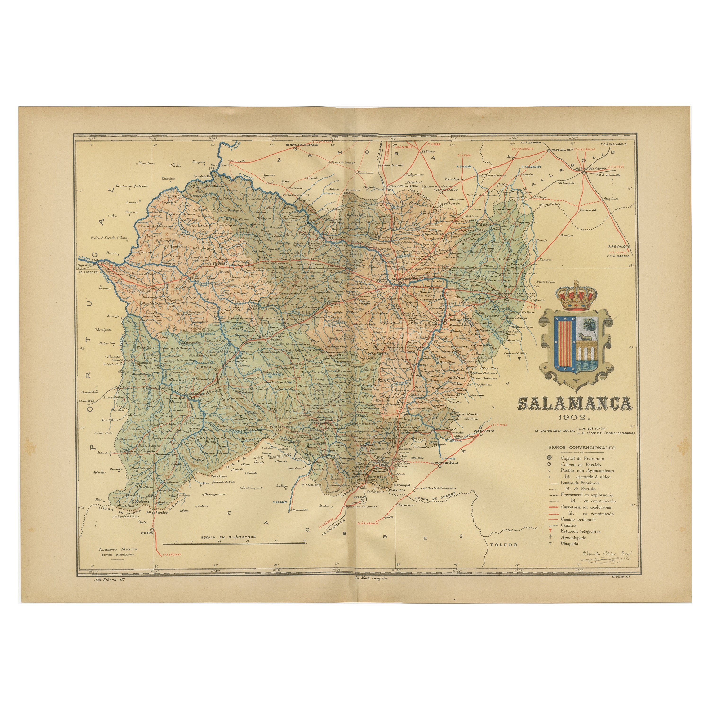
- 1902 Cartographic View of Salamanca: The Golden Province of SpainLocated in Langweer, NLThis map showcases the province of Salamanca in the year 1902. Salamanca is located in the autonomous community of Castile and León in western Spain. It is bordered by the provinces ...Category
Antique Early 1900s Maps
MaterialsPaper
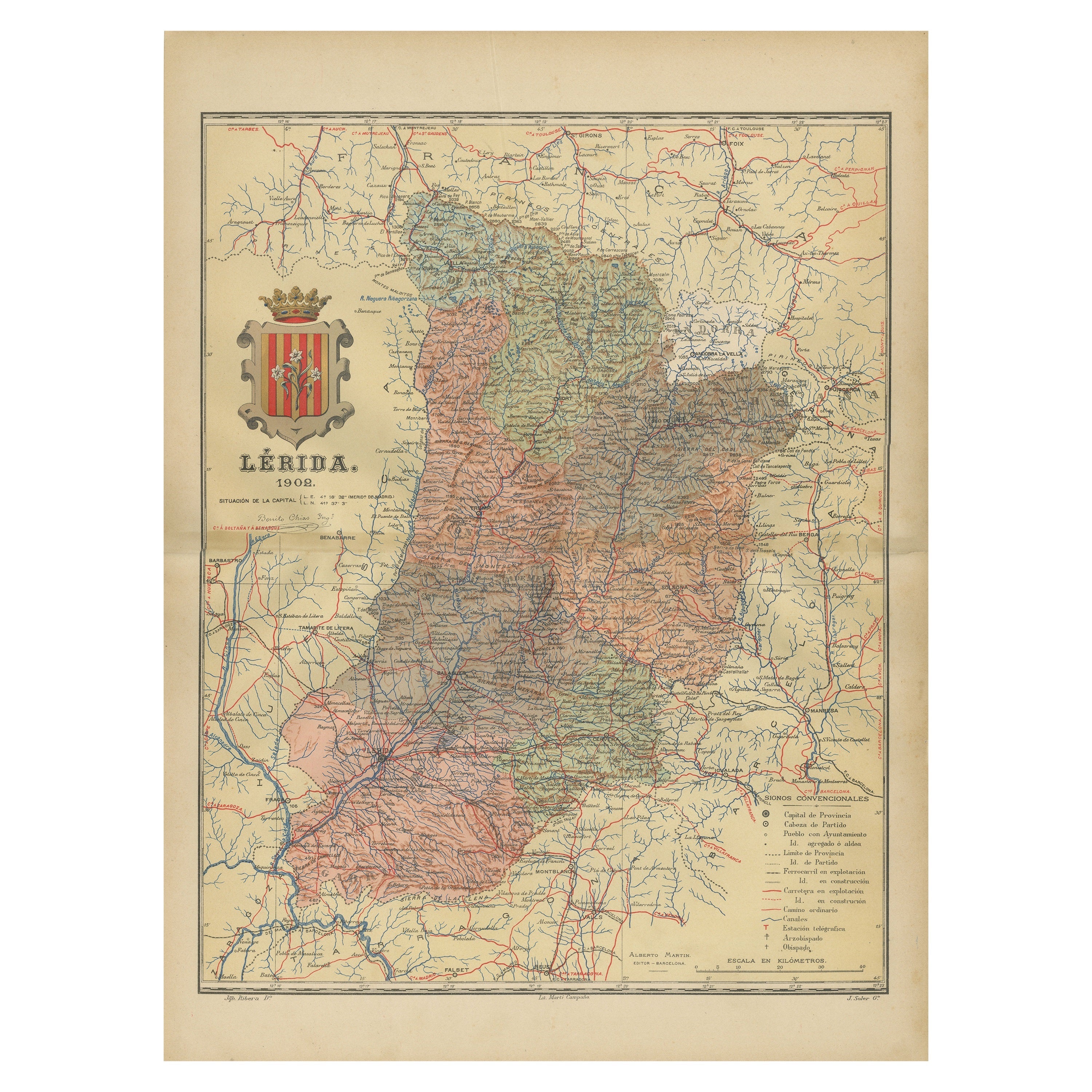
- Lleida 1902: A Cartographic Perspective of Catalonia's Gateway to the PyreneesLocated in Langweer, NLThe map for sale shows the province of Lleida, located in the western part of Catalonia, Spain, as of 1902. Here are the key features depicted on the map: - **Topography**: The map ...Category
Antique Early 1900s Maps
MaterialsPaper
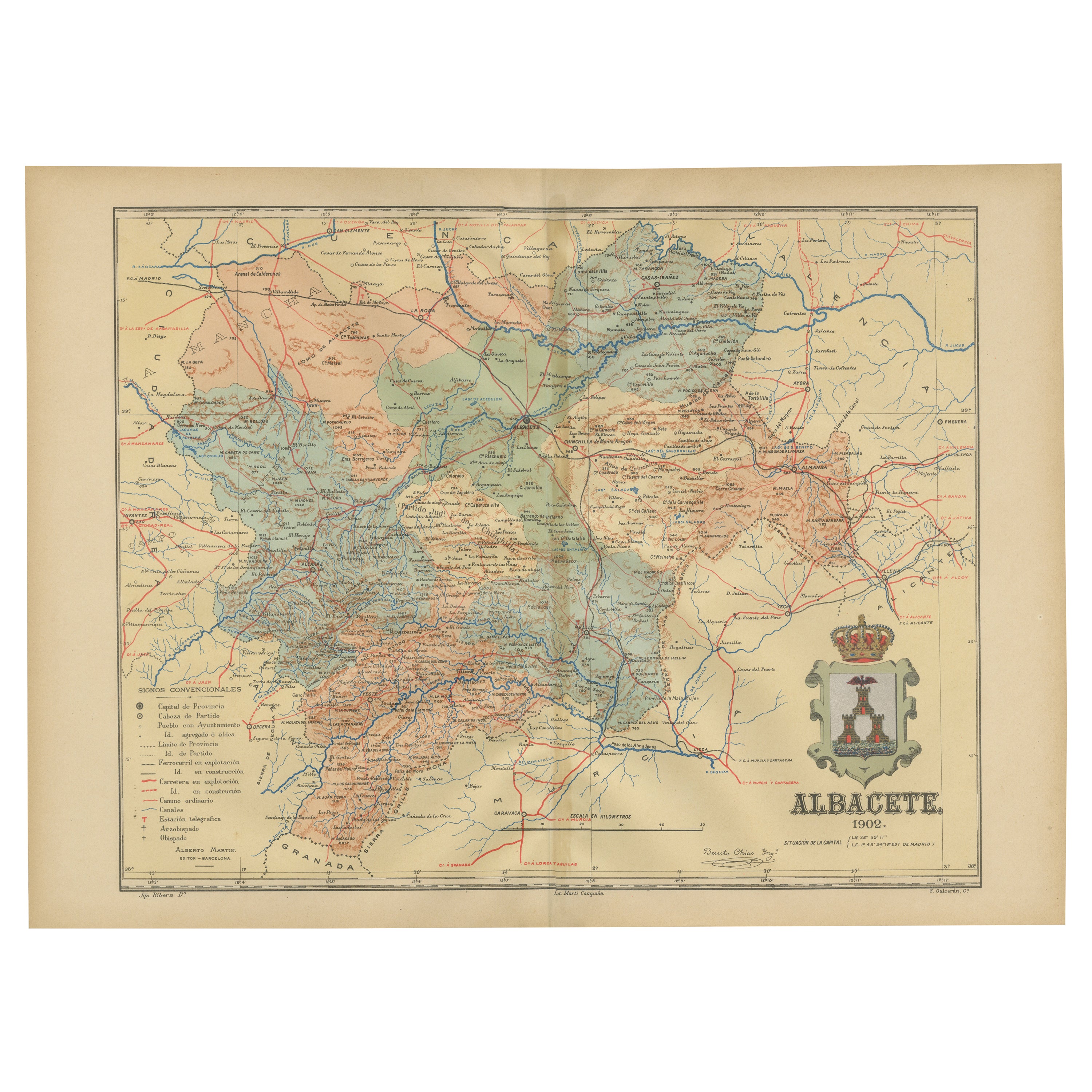
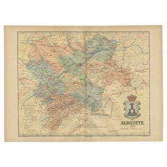
- Albacete, Spain - 1902: A Cartographic Depiction of Landscape and InfrastructureLocated in Langweer, NLAlbacete, Spain - 1902: A Cartographic Depiction of Landscape and Infrastructure An original and historical map of the province of Albacete, dated 1902, from the "Atlas Geográfico I...Category
Antique Early 1900s Maps
MaterialsPaper
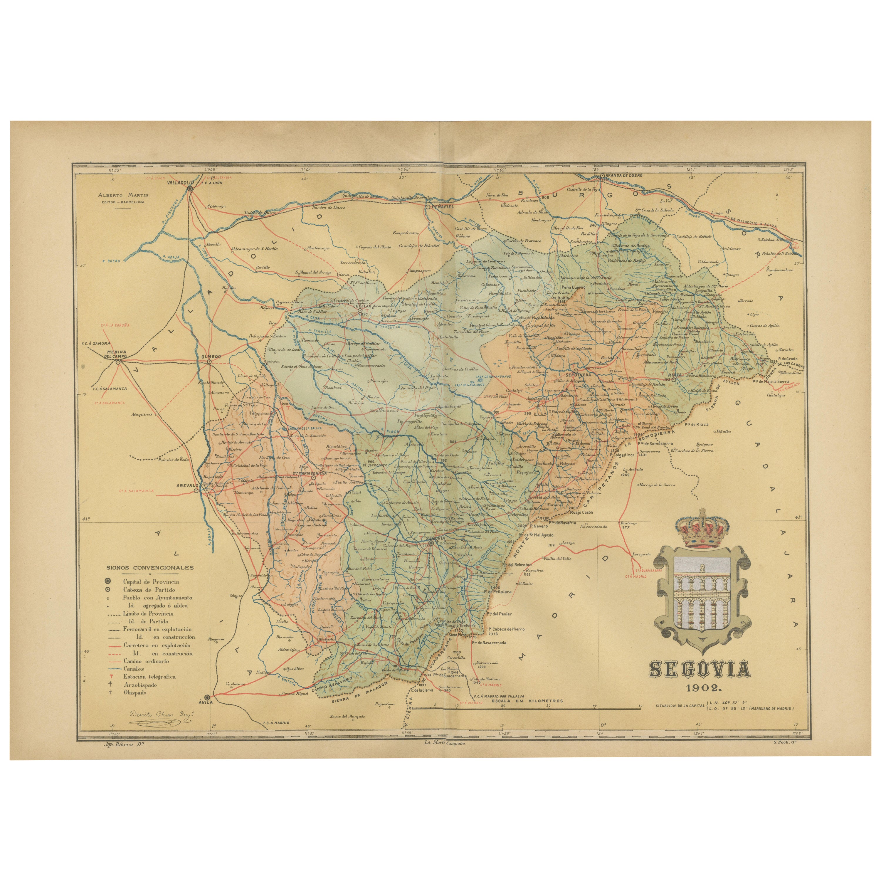
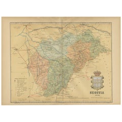
- Topographical and Administrative Cartography of Segovia in Spain, 1902Located in Langweer, NLAn original old map of the province of Segovia from the year 1902. Segovia is a historic area located in the central part of Spain, northwest of Madrid. Known for its rich history, a...Category
Antique Early 1900s Maps
MaterialsPaper


You May Also Like
- Sun and Moon a Story of Astronomy, Photography and CartographyLocated in New York City, NYA unique pictorial history of astronomical exploration from the earliest Prehistoric observatories to the latest satellite images with 280 spectacular images and an inspiring story i...Category
21st Century and Contemporary European Books
MaterialsPaper
- Antique Oarsman's Map of the River Thames, English, Cartography, Published 1912Located in Hele, Devon, GBThis is an antique copy of The Oarsman's and Angler's Map of the River Thames - New Edition. An English, bound map book, published in English by Edward Stanford, London, this new edi...Category
Early 20th Century British Other Books
MaterialsPaper
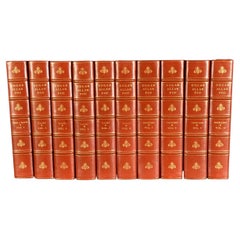
- 1902 The Complete Works of Edgar Allan PoeLocated in Bath, GBA beautiful limited edition set of the complete works of Edgar Allan Poe, illustrated with ten plates to each volume, and signed by the publisher. The Arnheim Edition of Poe's works...Category
Antique Early 1900s Books
MaterialsPaper
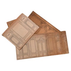
- Original plans and projects for the redevelopment of Hursley Park: 1902 - 1904Located in SAINT-OUEN-SUR-SEINE, FRThis set of model elements accompanied by plans constitutes part of the project to redevelop the Hursley Park mansion, also called , commissioned by the Coopers family who acquired it in 1902. The project is entrusted to the architect Scottish Alexander Marshall Mackenzie (1848-1933). Originally built in the early 1720s, Hursley House was purchased in 1902 by Sir George Cooper and his wife Mary Emma Smith. Their desire to transform the place into an 18th century palace is perfectly illustrated by the purchase, to decorate their ballroom, of 18th century Beauvais tapestries. The decor was to highlight the French art collections of the Hursley Park mansion. The model elements that we present perfectly embody an eclectic taste for the arts of the 18th century, and in particular the ornamentation which simultaneously summons all the styles up to that of Louis XIV. The model, representing the decorations, allows you to see all the opulence of the interior of Hursley House. Large openings hosting tapestries, highlighted by richly decorated woodwork, frame large doors or mirrors displaying large garlands of flowers. The main model presents an interior design project for the “Grand Salon”. Another part of the models is dedicated to the representation of a bedroom of Mrs. Gould, on cardboard made by Tochon-Lepage & Cie. The model of the Grand Salon, probably an abandoned project of the Drawing Room which was actually completed, presents a sumptuous decoration in a Regency style. Rectangular in shape, the two longest walls of the room in turn present a decor decorated with tapestries and a series of three windows accompanied by a large mirror. The two smaller walls facing each other have on one side a fireplace topped...Category
Early 20th Century English Belle Époque Models and Miniatures
MaterialsPaper, Wood
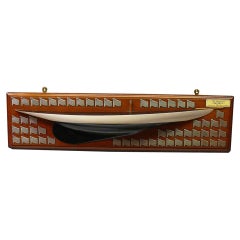
- Half Hull Model and Framed Photograph of the Yacht 'Barabel', circa 1902.Located in London, GBA rare builders half hull boat model of the 36 Linear Rater yacht Barabel, designed by A Mylne, Glasgow. The half hull boat model is made from solid timber, and painted cream to the waterline with painted caveta and black below, with a black deck. Bearing an ivorine plaque inscribed: Mr C.MacIver's "Barabel" 36LR designed by A Mylne, Glasgow on a mahogany backboard, set with 56 silver regatta prize flags, circa 1902-1904. The nautical half hull comes together with a framed photograph of Barabel sailing at sea. Alfred Mylne was apprenticed to the famous Scottish shipbuilders, Napier Shanks and Bell. He then worked as draftsman to G.L. Watson, where he was involved in drawing up the plans of the Royal Yacht "Britannia," the magnificent racing cutter that was first owned by the Prince of Wales [later King Edward VII] and which later passed to his son, King George V. Mylne set up his own office in 1896, which almost certainly makes the firm that still bears his name the world's oldest yacht design business in continuous production. Mylne immediately established a reputation as a designer of winning yachts, and was one of the people behind the most successful yacht handicap rules of all time - the International Metre Rule. Mylne designs were always admired for their elegance, and this was one of the attractions that drew owners to commission cruisers of every size from his design board...Category
Early 20th Century British Nautical Objects
MaterialsSterling Silver
- Antique Lithography Map of Cheshire, English, Framed, Cartography, VictorianLocated in Hele, Devon, GBThis is an antique lithography map of Cheshire. An English, framed atlas engraving of cartographic interest, dating to the mid 19th century and lat...Category
Antique Mid-19th Century British Victorian Maps
MaterialsWood


Recently Viewed
View AllMore Ways To Browse
Map Of Old Armenia
Teak Wood Sphere
Nova Guinea Maps
Antique Map Of Illinois
Petite Point Hand Bag
Antique Map Of Southeastern Us
Antique Map Alabama
Antique Map Of Sydney
Malay Archipelago Map
Gambia Antique Map
Uruguay Antique Map
Guyana Antique Map
Ruscelli Map
Masque Theatre No
Nova Scotia Map
Antique Map Tuscany
Berkshire Antique Map
Cornwall Map