Items Similar to Map of the Electorate of Bavaria, Incl Lake Constance, by Jesuit Scherer, c.1700


Want more images or videos?
Request additional images or videos from the seller
1 of 5
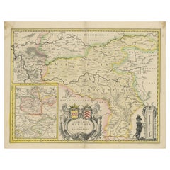
Map of the Electorate of Bavaria, Incl Lake Constance, by Jesuit Scherer, c.1700
$592.40
$740.5020% Off
£438.96
£548.7020% Off
�€496
€62020% Off
CA$819.49
CA$1,024.3620% Off
A$903.13
A$1,128.9220% Off
CHF 472.82
CHF 591.0320% Off
MX$11,093.33
MX$13,866.6620% Off
NOK 5,941.09
NOK 7,426.3620% Off
SEK 5,560.39
SEK 6,950.4820% Off
DKK 3,777.41
DKK 4,721.7620% Off
About the Item
Antique map titled 'Electorat Bavariae.' Map of the Electorate of Bavaria by the Jesuit Heinrich Scherer. The lower map shows the Lake Constance. Source unknown, to be determined.
Artists and Engravers: Heinrich Scherer (1628-1704) was a Professor of Hebrew, Mathematics and Ethics at the University of Dillingen until about 1680. Thereafter he obtained important positions as Official Tutor to the Royal Princes of Mantua and Bavaria. It was during his time in Munich as Tutor to the Princely house of Bavaria that his lifetime’s work as a cartographer received acclaim and recognition. Scherer’s world atlas, the Atlas Novus, first published in Munich between 1702 and 1710 and reissued in a second edition between 1730 and 1737, forms a singularly unusual, almost revolutionary work in terms of the development of European mapmaking at the beginning of the 18th Century.
Condition: Good, given age. Irregular left edge from binding. General age-related toning and/or occasional minor defects from handling. Please study image carefully.
- Dimensions:Height: 10.63 in (27 cm)Width: 8.47 in (21.5 cm)Depth: 0 in (0.02 mm)
- Materials and Techniques:
- Period:1700-1709
- Date of Manufacture:circa 1700
- Condition:Wear consistent with age and use. Condition: Good, given age. Irregular left edge from binding. General age-related toning and/or occasional minor defects from handling. Please study image carefully.
- Seller Location:Langweer, NL
- Reference Number:Seller: PCT-61425 1stDibs: LU3054326888462
About the Seller
5.0
Recognized Seller
These prestigious sellers are industry leaders and represent the highest echelon for item quality and design.
Platinum Seller
Premium sellers with a 4.7+ rating and 24-hour response times
Established in 2009
1stDibs seller since 2017
2,618 sales on 1stDibs
Typical response time: <1 hour
- ShippingRetrieving quote...Shipping from: Langweer, Netherlands
- Return Policy
Authenticity Guarantee
In the unlikely event there’s an issue with an item’s authenticity, contact us within 1 year for a full refund. DetailsMoney-Back Guarantee
If your item is not as described, is damaged in transit, or does not arrive, contact us within 7 days for a full refund. Details24-Hour Cancellation
You have a 24-hour grace period in which to reconsider your purchase, with no questions asked.Vetted Professional Sellers
Our world-class sellers must adhere to strict standards for service and quality, maintaining the integrity of our listings.Price-Match Guarantee
If you find that a seller listed the same item for a lower price elsewhere, we’ll match it.Trusted Global Delivery
Our best-in-class carrier network provides specialized shipping options worldwide, including custom delivery.More From This Seller
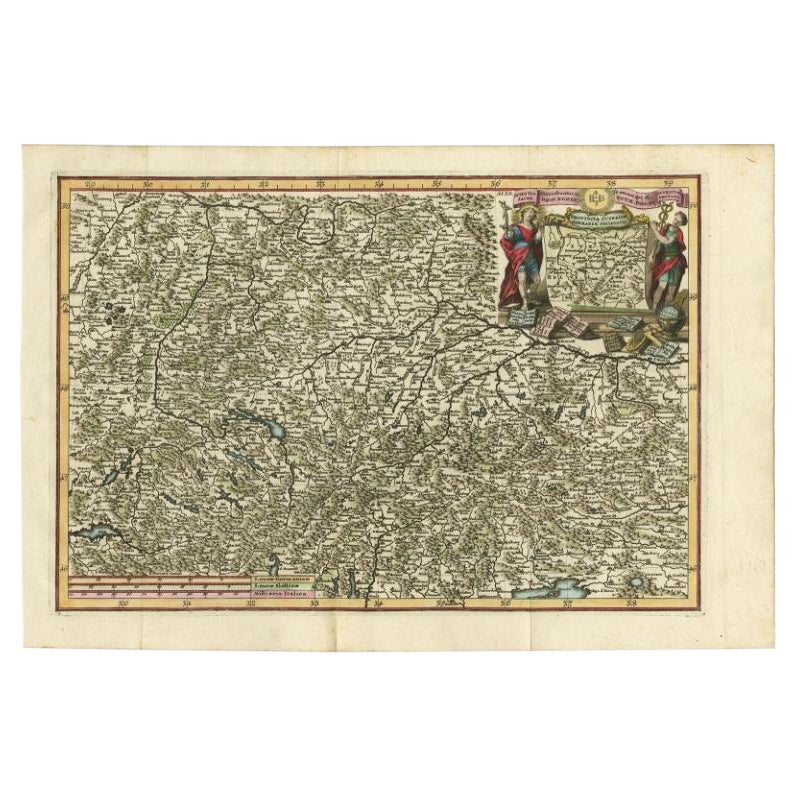
View AllVery Detailed Antique Map of the Jesuit Province of Bavaria, Germany, c.1700
Located in Langweer, NL
Antique map titled 'Provinciae Superior Germaniae Societatis.' Very detailed map of the Jesuit province of Bavaria, Germany. Source unknown, to be determined.
Artists and Engravers:...
Category
Antique 18th Century Maps
Materials
Paper
$573 Sale Price
20% Off
Antique Map of Switzerland by J.B. Homann, 1751
By Johann Baptist Homann
Located in Langweer, NL
Decorative example of Homann's map of Switzerland, with decorative cartouche and the coat of arms of each of the 13 Cantons.
Category
Antique Mid-18th Century Maps
Materials
Paper

$563 Sale Price
20% Off
Decorative Antique Map of Austria – Frederick de Wit, Amsterdam c.1690
Located in Langweer, NL
Antique Map of Austria – “Circuli Austriaci pars Septentrionalis” by F. de Wit, c.1670
This finely engraved map, titled “Circuli Austriaci pars Septent...
Category
Antique Late 17th Century Dutch Maps
Materials
Paper

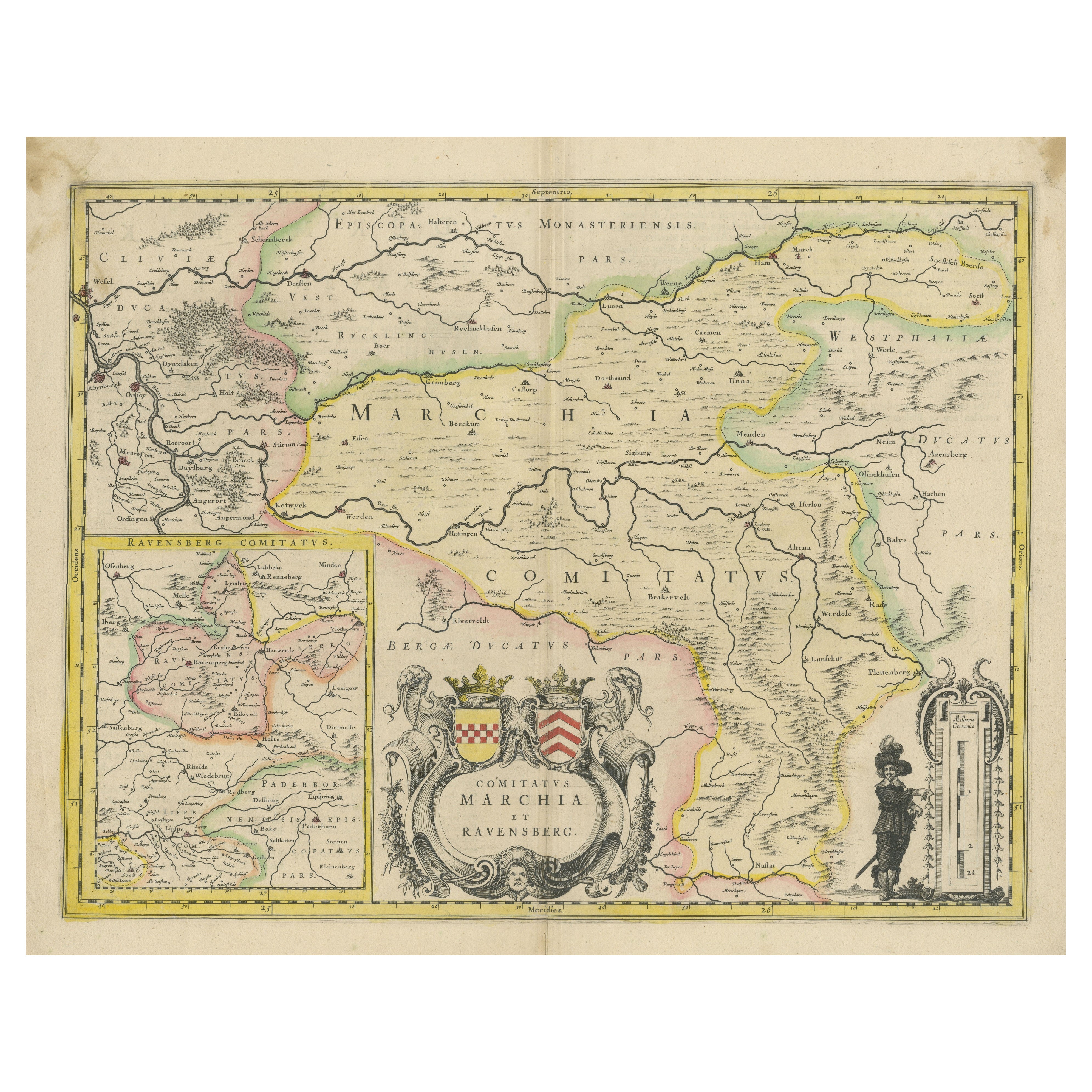
Map of Comitatus Marchia et Ravensberg: Historical Counties in Germany, c.1660
Located in Langweer, NL
Antique map titled 'Comitatus Marchia et Ravensberg'. This map depicts two historical counties of the Holy Roman Empire: Marks and Ravensberg. Major cities, towns, mountains, and riv...
Category
Antique Mid-17th Century Dutch Maps
Materials
Paper
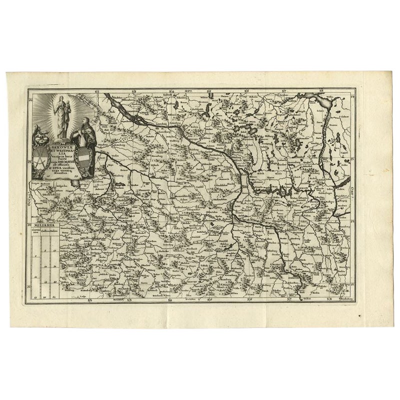
Antique Map of Saxony and Westphalia by Scherer, 1699
Located in Langweer, NL
Antique map titled 'Saxonia et Westphalia varijs in locis sacris erga dei matre est officiosa & ipsa vicissim erga utramq. Munifica.' Detailed uncommon map of Saxony and Westphalia i...
Category
Antique 17th Century Maps
Materials
Paper
$214 Sale Price
20% Off
Antique Map of Germany by T. Kitchin, circa 1770
Located in Langweer, NL
Antique map titled 'An Accurate Map of Germany (..) '. Drawn from the best Authorities by T.Kitchin Geogr." Rare edition, drawn and etched by Thomas Kitchin, published, circa 1770.
Category
Antique Mid-18th Century Maps
Materials
Paper

$229 Sale Price
20% Off
You May Also Like
Original Antique Map of Switzerland, Engraved By Barlow, Dated 1807
Located in St Annes, Lancashire
Great map of Switzerland
Copper-plate engraving by Barlow
Published by Brightly & Kinnersly, Bungay, Suffolk.
Dated 1807
Unframed.
Category
Antique Early 1800s English Maps
Materials
Paper

17th Century Nicolas Visscher Map of Southeastern Europe
Located in Hamilton, Ontario
A beautiful, highly detailed map of southeastern Europe by Nicolas Visscher. Includes regions of Northern Italy (showing the cities Bologna, Padua, and Venice), Bohemia, Austria (sho...
Category
Antique 17th Century Dutch Maps
Materials
Paper

$1,350 Sale Price
38% Off
1640 Joan Bleau Map Entitled"Diocecese de rheims et le pais de rethel, " Eic.a011
Located in Norton, MA
1640 Joan Bleau map entitled
"Diocecese de rheims et le pais de rethel,"
Ric.a011
OAN BLAEU
Diocecese de Rheims, et le pais de Rethel.
Handcolored engraving, c.1640.
...
Category
Antique 17th Century Dutch Maps
Materials
Paper

1656 Jansson Map Metz Region of France Entitled "Territorium Metense" Ric0014
Located in Norton, MA
1656 Jansson map Metz Region of France entitled "Territorium Metense."
Ric0014
" Authentic" - Map of the historical region surrounding Metz, in Lorraine, France.
Oriented with ...
Category
Antique 17th Century Dutch Maps
Materials
Paper

18th Century Map of the Southern Balkans by Giovanni Maria Cassini
By Giovanni Maria Cassini
Located in Hamilton, Ontario
18th century map by Italian engraver Giovanni Maria Cassini (Italy 1745-1824).
Map of the Southern Balkans: Rome. Hand colored and copper engraved print done in the year 1788. It in...
Category
Antique 18th Century Italian Maps
Materials
Paper

$795 Sale Price
36% Off
1657 Janssonius Map of Vermandois and Cappelle, Ric. A-004
Located in Norton, MA
1657 Janssonius map of
Vermandois and Cappelle
Ric.a004
Description: Antique map of France titled 'Descriptio Veromanduorum - Gouvernement de la Cappelle'. Two detailed maps o...
Category
Antique 17th Century Unknown Maps
Materials
Paper

More Ways To Browse
Royal Prince
1700 Antique Furniture
Bavaria Antique
Mughal Map
American West Antiques
Antique Map Ceylon
Antique Map Of The Philippines
Antique Mississippi Map
Celestial Map
Nevada Antique Map
17th Century American Furniture
Afghanistan Map
Antique Celestial Maps
Antique Maps Virginia
Hand Drawn Map
Map Of Puerto Rico
Sicily Map
Used Durham Furniture