Items Similar to Navigating the Spice Trade: A Maritime Chart of the Banda Sea, 1799

Want more images or videos?
Request additional images or videos from the seller
1 of 9
Navigating the Spice Trade: A Maritime Chart of the Banda Sea, 1799
$942.86
$1,178.5820% Off
£700.80
£87620% Off
€792
€99020% Off
CA$1,301.83
CA$1,627.2920% Off
A$1,443.64
A$1,804.5520% Off
CHF 758.52
CHF 948.1520% Off
MX$17,638.78
MX$22,048.4720% Off
NOK 9,490.17
NOK 11,862.7120% Off
SEK 8,908.14
SEK 11,135.1820% Off
DKK 6,030.68
DKK 7,538.3520% Off
About the Item
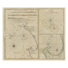
This original antique map is an 18th-century nautical chart by Laurie & Whittle, a well-known British firm that was involved in the publication of maps, charts, and maritime books. The title suggests that it is specifically a chart of the Banda Sea, which lies in a region historically known as the Spice Islands, now part of modern-day Indonesia.
The full title of the map, "A New Chart of the Banda Sea, Including The Isles of Amboyna, and Banda, Those of Bouro, Ceram and The Circumjacent Islands; with the N.E. End of Timor," indicates its coverage of key islands in the area. The inclusion of insets for the Bay of Amboyna and the Islands of Banda, Goonong-Appee, and Banda Neira shows a detailed representation of important locations within the Spice Islands, known for their production of nutmeg, mace, and cloves—spices that were highly valued and sought after in Europe and other parts of the world.
Laurie & Whittle was a partnership between Robert Laurie and James Whittle. They took over the business of Robert Sayer, another prominent figure in the map and print publishing industry, around 1794. The chart reflects the navigational and geographical knowledge of the time, providing not only the geographical layout of the islands but also navigational lines and details important for seafaring.
This particular chart would have been used for maritime navigation, helping ships traverse the complex island networks of the Indonesian archipelago. It’s part of the era's significant cartographic work, representing the combination of exploration, maritime trade, and the European interest in colonial expansion. The detail and accuracy of such maps would have been crucial for trading companies like the Dutch East India Company, which was actively engaged in the spice trade in this region.
In terms of detail, we can observe that the map is gridded with lines for latitude and longitude, making it functional for navigation. The detail on the islands themselves includes topographical features and notes on the anchorages, soundings (measuring the depth of water), and hazards such as reefs or shallow areas. This was essential for ships that were navigating the often treacherous waters of the East Indies. The map’s decorative elements are minimal, focusing instead on its practical purpose for navigation and trade.
- Dimensions:Height: 18.67 in (47.4 cm)Width: 25.04 in (63.6 cm)Depth: 0.02 in (0.5 mm)
- Materials and Techniques:
- Period:
- Date of Manufacture:1799
- Condition:Repaired: Old fold to lower edge with splitting repaired verso. Engraving on thick laid paper without watermark. Shows overall toning. Two tears in upper part affecting image. Tape support in the lower border on the reverse. Please study image carefully.
- Seller Location:Langweer, NL
- Reference Number:Seller: BG-13470-21stDibs: LU3054339046612
About the Seller
5.0
Recognized Seller
These prestigious sellers are industry leaders and represent the highest echelon for item quality and design.
Platinum Seller
Premium sellers with a 4.7+ rating and 24-hour response times
Established in 2009
1stDibs seller since 2017
2,609 sales on 1stDibs
Typical response time: <1 hour
- ShippingRetrieving quote...Shipping from: Langweer, Netherlands
- Return Policy
Authenticity Guarantee
In the unlikely event there’s an issue with an item’s authenticity, contact us within 1 year for a full refund. DetailsMoney-Back Guarantee
If your item is not as described, is damaged in transit, or does not arrive, contact us within 7 days for a full refund. Details24-Hour Cancellation
You have a 24-hour grace period in which to reconsider your purchase, with no questions asked.Vetted Professional Sellers
Our world-class sellers must adhere to strict standards for service and quality, maintaining the integrity of our listings.Price-Match Guarantee
If you find that a seller listed the same item for a lower price elsewhere, we’ll match it.Trusted Global Delivery
Our best-in-class carrier network provides specialized shipping options worldwide, including custom delivery.More From This Seller
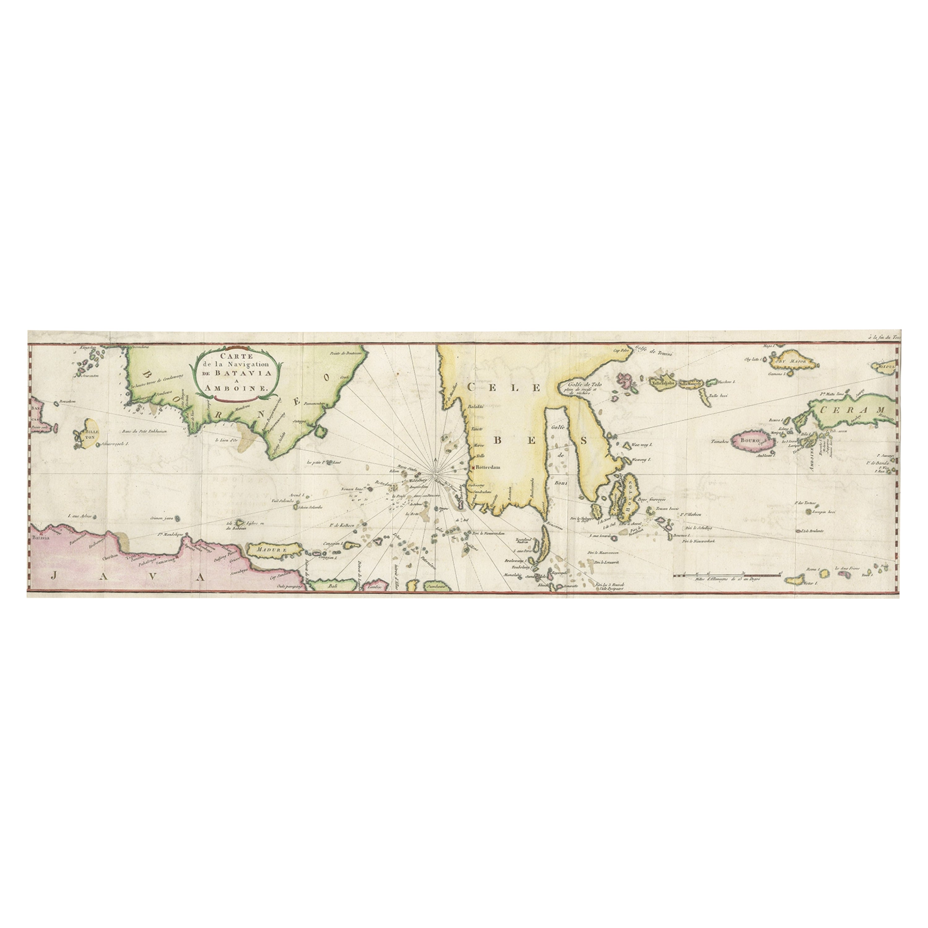
View AllRare Chart of Indonesia Including Borneo, Java, Celebes, Ceram and More, 1779
Located in Langweer, NL
Antique map titled 'Carte de la Navigation de Batavia a Amboina'.
Rare chart of Indonesia including Borneo, Java, Celebes, Ceram and more. This map originates from 'Voyage par le Cap...
Category
Antique 1770s Maps
Materials
Paper
$847 Sale Price
20% Off
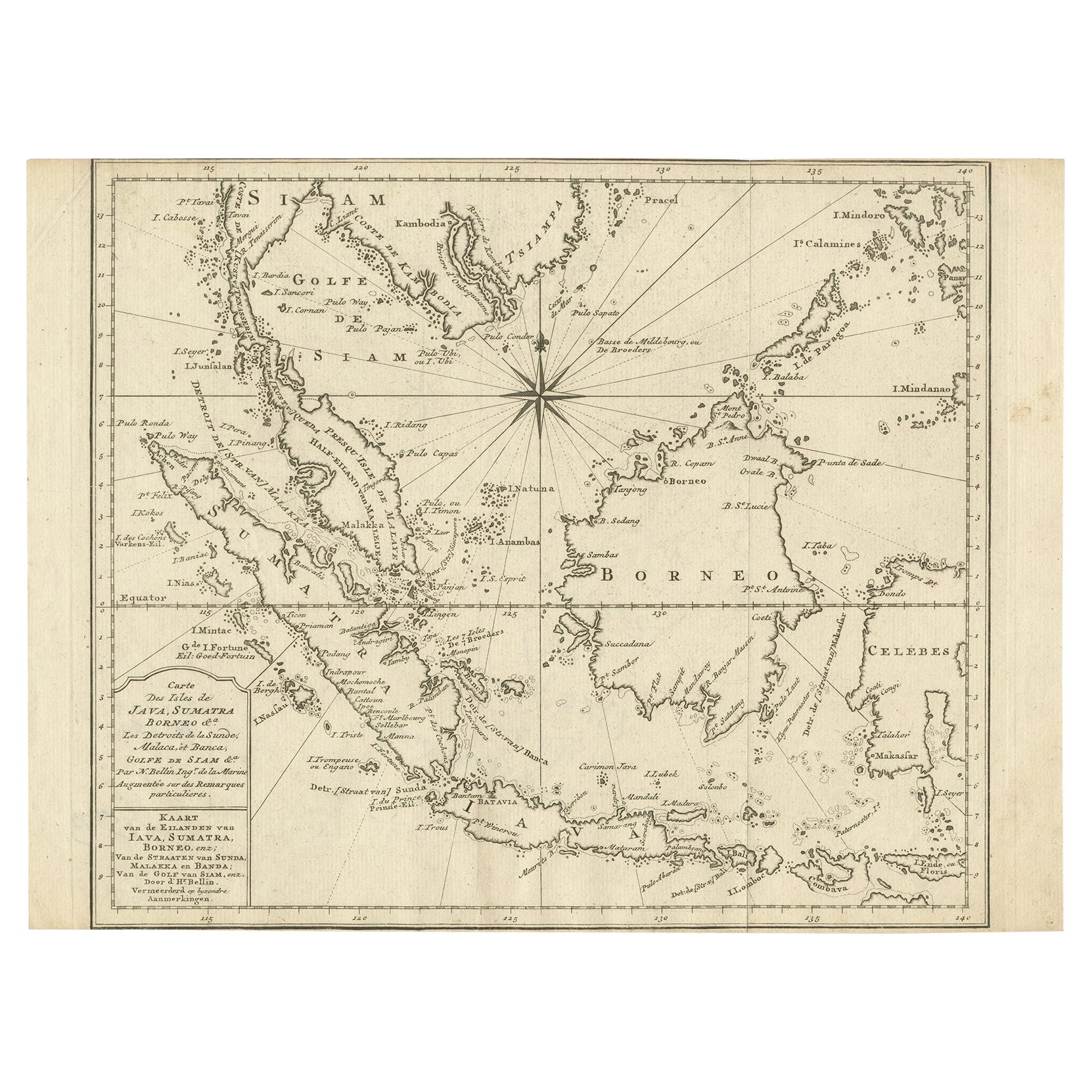
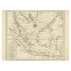
Original Map of the East Indies Including Sumatra, Java, Borneo & Malaysia, 1747
Located in Langweer, NL
Antique map titled 'Carte des Isles Java, Sumatra, Borneo (..) - Kaart van de Eilanden van Iava, Sumatra, Borneo (..)'.
Map of the East Indies including Sumatra, Java, Borneo and...
Category
Antique 1740s Maps
Materials
Paper
$428 Sale Price
20% Off
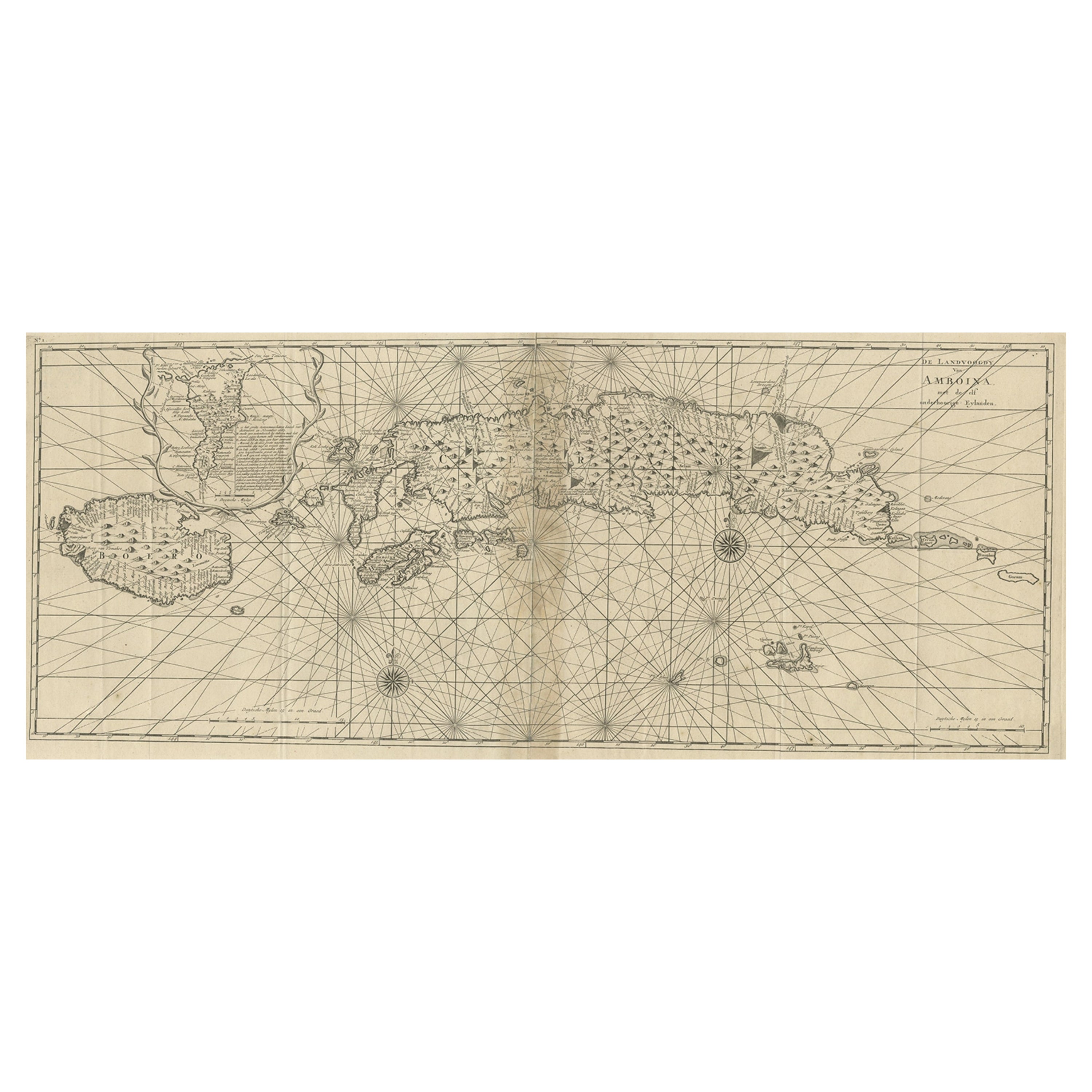
Antique Map of the Moluccas or the Famed Spice Islands of Indonesia, 1724
Located in Langweer, NL
Antique map Spice Islands titled 'De landvoogdy van Amboina met de elf onderhoorige Eylanden'.
This map depicts the central islands of the Maluku Arc...
Category
Antique 1720s Maps
Materials
Paper
$847 Sale Price
20% Off
Early Chart Identifying British Spice Trading Colony of Bencoolen, Sumatra, 1797
Located in Langweer, NL
Antique map titled 'A Chart of the West Coast of Sumatra'.
Early nautical chart identifying the British spice trading colony of Bencoolen and F...
Category
Antique 1790s Maps
Materials
Paper
$1,190 Sale Price
20% Off
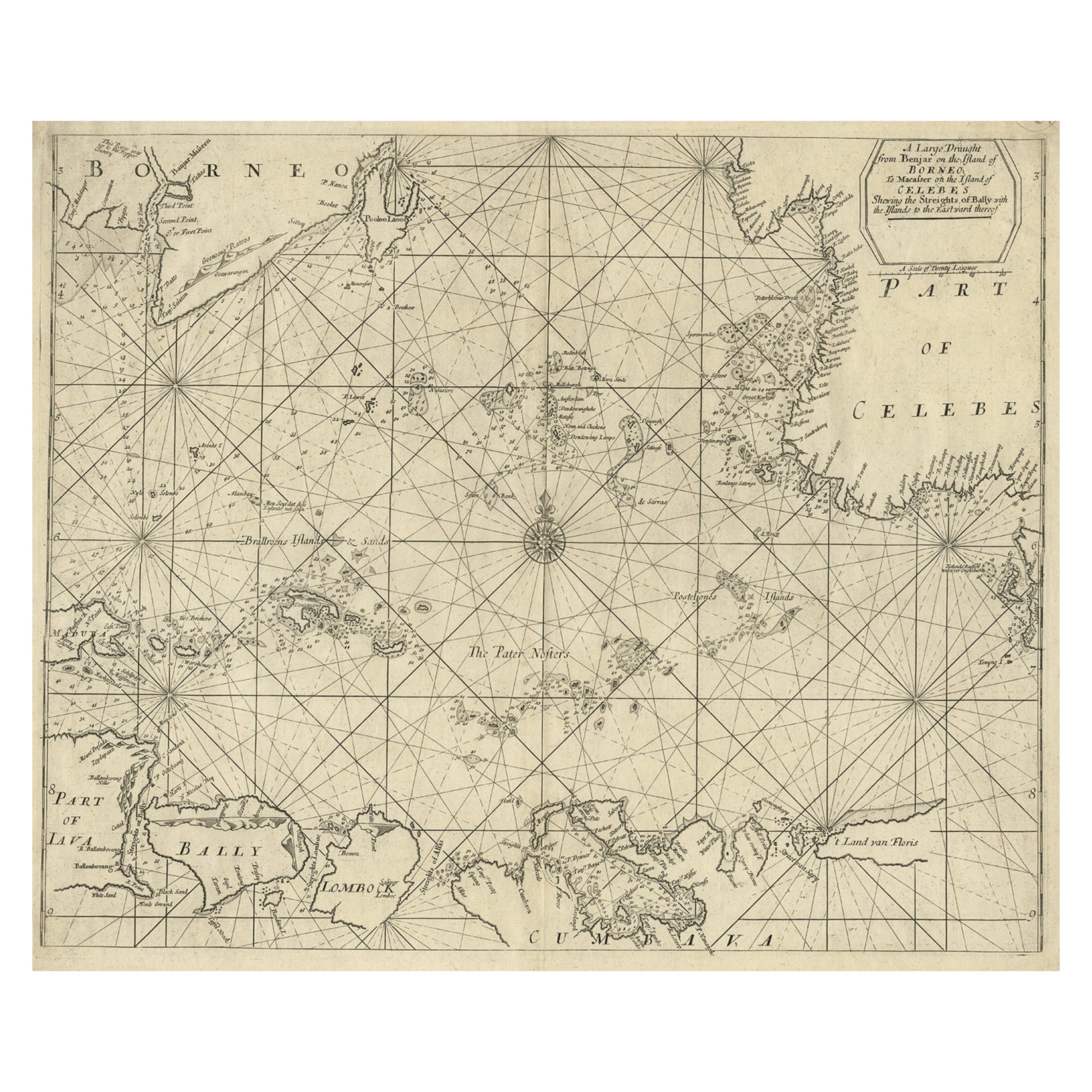
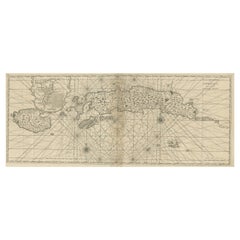
Rare Antique English SeaChart of Bali, Lombok, Floris, Borneo, Celebes etc, 1711
Located in Langweer, NL
Antique map titled 'A Large Draught from Benjar on the Island of Borneo To Macasser on the Island of Celebes Shewing the Streight of Bally with the Islands to the Eastward thereof.' ...
Category
Antique 1710s Maps
Materials
Paper
$2,333 Sale Price
20% Off
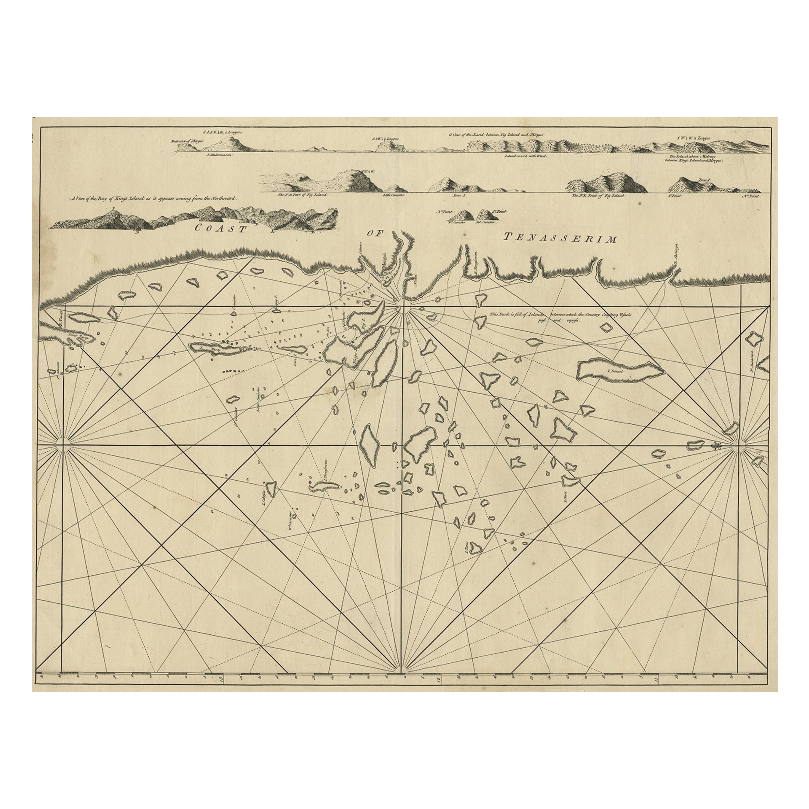
Old Sea Chart of the Tenasserim area, Myanmar 'Burma' in South East Asia, c.1790
Located in Langweer, NL
Antique map titled 'Coast of Tenasserim.'
Sea chart of the Tenasserim area, Myanmar in South East Asia. Source unknown, to be determined.
Artists and Engravers: Anonymous.
Category
Antique 1790s Maps
Materials
Paper
$704 Sale Price
20% Off
You May Also Like
Chart of Boston's North Shore
Located in Norwell, MA
Rarely found restrike of an 1804 chart by Nathanael Bowditch of the Harbors of Salem, Marblehead, Beverly, and Manchester.
Showing the Islands of Great Misery, Satan, Cuney, Winter,...
Category
Vintage 1980s North American Maps
Materials
Paper

Antique 1803 Italian Map of Asia Including China Indoneseia India
Located in Amsterdam, Noord Holland
Antique 1803 Italian Map of Asia Including China Indoneseia India
Very nice map of Asia. 1803.
Additional information:
Type: Map
Country of Manufacturing: Europe
Period: 19th centu...
Category
Antique 19th Century European Maps
Materials
Paper

$584 Sale Price
20% Off
Original Antique Map of South East Asia by Thomas Clerk, 1817
Located in St Annes, Lancashire
Great map of South East Asia
Copper-plate engraving
Drawn and engraved by Thomas Clerk, Edinburgh.
Published by Mackenzie And Dent, 1817
Unframed.
Category
Antique 1810s English Maps
Materials
Paper

Antique Map of the Southern Oceans, South America and Africa
Located in New York, NY
Antique Map of the South Atlantic, c. 1800s
Engraving
20 x 28 in.
Framed: 25 3/4 x 33 3/4 in.
Category
19th Century Realist Figurative Prints
Materials
Engraving
Antique Maritime Chart of East Coast Virginia to Nova Scotia
Located in Norwell, MA
1920 nautical chart of the East Coast of the United States from Virginia to Maine, New Brunswick, and Nova Scotia. The chart shows Cape Cod, Long Island, the Connecticut coast, Jersey Shore, Maine, New Hampshire, etc. Very detailed, showing ports, lighthouses, shoals, depths, etc. The chart is by famous cartographer George W. Eldridge, compiled from surveys of the United States government, British Admiralty, George Eldridge, and others. First authorized by George Eldridge, published in 1916 by Wilfred O. White with a merchant's stamp of Charles Hutchinson...
Category
Vintage 1920s North American Maps
Materials
Paper

Original Antique Map of US Possessions In The Pacific Ocean, C.1900
Located in St Annes, Lancashire
Fabulous map of US possessions in the Pacific Ocean
Original color.
Engraved and printed by the George F. Cram Company, Indianapolis.
Published, C.1900.
Unframed.
Free shipping.
Category
Antique 1890s American Maps
Materials
Paper

More Ways To Browse
Used Trade Show Furniture
Antique Spices
East India Trading Company
British East India Company
British East Indies
Used Furniture Anchorage
Antique Nutmeg
20th Century Spanish Table
Antonio Bellini
Antique Oushak Carpets
Blue Coffee Tables
German Bauhaus Posters
1945 Chair Juhl
Antique Three Leg Table
Folke Arstrom
Silver Over Copper
Vintage Barware Glasses
Antique Etched Glass