1 of 1
Nova Totius Terrarum Orbis Geographica Ac Hydrographica Tabula, 1638
$20,000List Price
About the Item
- Creator:Willem Blaeu (Maker)
- Dimensions:Height: 19 in (48.26 cm)Width: 24 in (60.96 cm)Depth: 0.2 in (5.08 mm)
- Place of Origin:
- Period:Mid-17th Century
- Date of Manufacture:1638
- Condition:
- Seller Location:Houston, TX
- Reference Number:1stDibs: LU129322935852
Authenticity Guarantee
In the unlikely event there’s an issue with an item’s authenticity, contact us within 1 year for a full refund. DetailsMoney-Back Guarantee
If your item is not as described, is damaged in transit, or does not arrive, contact us within 7 days for a full refund. Details24-Hour Cancellation
You have a 24-hour grace period in which to reconsider your purchase, with no questions asked.Vetted Professional Sellers
Our world-class sellers must adhere to strict standards for service and quality, maintaining the integrity of our listings.Price-Match Guarantee
If you find that a seller listed the same item for a lower price elsewhere, we’ll match it.Trusted Global Delivery
Our best-in-class carrier network provides specialized shipping options worldwide, including custom delivery.You May Also Like
Southern Sweden Provinces Map – Homann’s ‘Nova Tabula Scaniae’, ca. 1730
Located in Langweer, NL
Southern Sweden Provinces Map – Homann’s ‘Nova Tabula Scaniae’, ca. 1730
Antique map titled 'Nova Tabula Scaniae in qua sunt Scania, Blekingia et Hallandia'. This decorative map sho...
Category
Antique Mid-18th Century German Maps
Materials
Paper

$526 Sale Price
20% Off
H 20.87 in W 24.61 in D 0.02 in
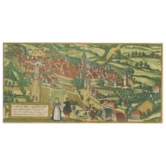
Engraving of St. Gallen and its Monastery, from Civitates Orbis Terrarum (1575)
Located in Langweer, NL
Description of the Engraving: Braun & Hogenberg’s "S. Galli Opp. et Monasterium Heluetiorum" from Civitates Orbis Terrarum (1575)
This is an original, hand-colored copper engraving ...
Category
Antique 16th Century Maps
Materials
Paper
$660 Sale Price
20% Off
H 9.85 in W 21.66 in D 0 in
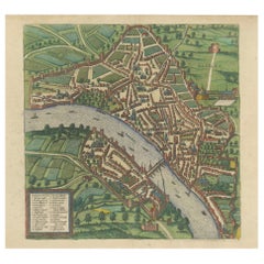
Bird’s-Eye View of Basel from Braun & Hogenberg’s Civitates Orbis Terrarum, 1575
Located in Langweer, NL
Bird’s-Eye View of Basel from Braun & Hogenberg’s "Civitates Orbis Terrarum" (Circa 1572-1617)
This highly detailed map of Basel is a bird's-eye view, originally based on Sebastian Münster’s map...
Category
Antique 16th Century Maps
Materials
Paper
$1,148 Sale Price
20% Off
H 16.15 in W 21.26 in D 0 in
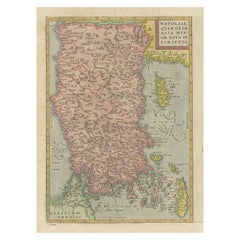
Asia Minor – Antique Map of Natolia by Ortelius, Theatrum Orbis Terrarum c.1600
Located in Langweer, NL
Asia Minor – Antique Map of Natolia by Ortelius, Theatrum Orbis Terrarum c.1600
This beautifully hand-colored antique map titled Natoliae quae olim Asia Minor nova descriptio presen...
Category
Antique Early 17th Century European Maps
Materials
Paper
$421 Sale Price
20% Off
H 17.41 in W 11.19 in D 0.02 in
Antique Map of the Old World Projection, Entitled Orbis Terrarum Ad Mentem, 1825
Located in Langweer, NL
Antique map titled 'Orbis Terrarum ad Mentem (..)'. Old map of the world originating from 'Atlas der Oude Wereld'.
Artists and Engravers: Published by C. Ph. Funke and W. van Boe...
Category
Antique 19th Century Maps
Materials
Paper
$210 Sale Price
20% Off
H 8.51 in W 9.77 in D 0 in
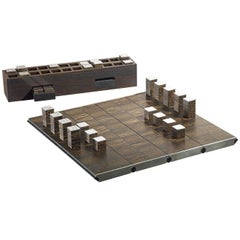
Tabula Aurea Chessboard
By Giordano Viganò
Located in Milan, IT
This wooden chessboard features an edge covered in ebony wood and silver. The top is foldable and becomes a box that contains the pieces. The top layer of each piece is covered by si...
Category
2010s Italian Games
Materials
Silver
VISIONAIRE 12: Desire (1638/2000)
By Visionaire
Located in Kleinburg, ON
From the Visionaire website:
12 DESIRE is our collaboration with DIFFA, Design Industries Foundation Fighting AIDS. The art dealer Paul Morris helped us gather all the original artw...
Category
1990s American Books
Materials
Paper

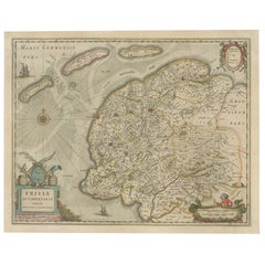
Antique Map of Friesland, The Netherlands, 1638
Located in Langweer, NL
Antique map titled 'Frisia Occidentalis'.
Original antique map of Friesland, the Netherlands. First state, originating from 'Atlantis novi pars secunda' published 1638.
Artis...
Category
Antique 17th Century Maps
Materials
Paper
Antique Map of Guinea in West Africa by Blaeu, c.1638
Located in Langweer, NL
Antique map titled 'Guinea'.
Decorative map of West Africa, including numerous animals in the interior, sailing ships and several elegant cartouches. Both the map and the sea are s...
Category
Antique 17th Century Maps
Materials
Paper
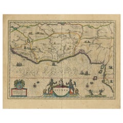
$526 Sale Price
20% Off
H 18.59 in W 23.04 in D 0 in
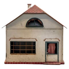
Antique Doll House, AC-0149
Located in Scottsdale, AZ
Antique Doll House
Item #: AC-0214-03
Dimensions: 29”W x 19”D x 30”H
Category
Antique 19th Century Toys and Dolls
Materials
Wood
Recently Viewed
View AllMore Ways To Browse
Blaeu World Map
Maps Of New Mexico
Antique Map Of Argentina
Antique Map Of Colombia
Cornwall Map
Early Texas Furniture
Iraq Map
James Cook Map
Kentucky Antiques
Map Of Mexican California
Montreal Map
Mughal Map
Napoleon Map
Rand Mcnally Vintage Maps
Tunisia Antique Map
Used Office Furniture Rhode Island
Antique Chesapeake Bay Map
Antique Copper Australia