Items Similar to Original Antique Map of Zuid-Holland in the Netherlands by Blaeu, C.1645
Want more images or videos?
Request additional images or videos from the seller
1 of 6
Original Antique Map of Zuid-Holland in the Netherlands by Blaeu, C.1645
$525.84
$657.3020% Off
£389.28
£486.6020% Off
€440
€55020% Off
CA$727.63
CA$909.5320% Off
A$802.07
A$1,002.5920% Off
CHF 419.68
CHF� 524.6020% Off
MX$9,841.14
MX$12,301.4220% Off
NOK 5,282.95
NOK 6,603.6920% Off
SEK 4,940.39
SEK 6,175.4920% Off
DKK 3,350.16
DKK 4,187.7020% Off
About the Item
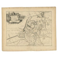
Antique map titled 'Zuydhollandia stricte sumta'. Old map of the province of Zuid-Holland, the Netherlands. This map originates from 'Theatrum Orbis Terrarum (..)'.
Artists and Engravers: Willem Janszoon Blaeu was born 1571 in Alkmaar. He was trained from 1594 to 1596 by the famous danish astronomer Tycho Brahe. 1599 he went to Amsterdam and founded a business as globe maker. Later he started producing map and sea charts, including his first world map in 1605. His most famous work was the "Atlas Novus" or "Theatrum Orbis Terrarum sive Atlas Novus" of 1635, which was published until 1655 in total six volumes. After Blaeu's death in 1638 his sons Joan and Cornelis continued the businees and finished the "Atlas Novus" and started an even larger work, the "Atlas Maior", which reached 12 volumes.
Condition: Fair, general age-related toning. Trimmed to plate mark, mounted and margins extended. Please study image carefully.
Date: c.1645
Overall size: 63 x 52 cm.
Image size: 50.5 x 38.5 cm.
We sell original antique maps to collectors, historians, educators and interior decorators all over the world. Our collection includes a wide range of authentic antique maps from the 16th to the 20th centuries. Buying and collecting antique maps is a tradition that goes back hundreds of years. Antique maps have proved a richly rewarding investment over the past decade, thanks to a growing appreciation of their unique historical appeal. Today the decorative qualities of antique maps are widely recognized by interior designers who appreciate their beauty and design flexibility. Depending on the individual map, presentation, and context, a rare or antique map can be modern, traditional, abstract, figurative, serious or whimsical. We offer a wide range of authentic antique maps for any budget.
- Dimensions:Height: 20.48 in (52 cm)Width: 24.81 in (63 cm)Depth: 0 in (0.01 mm)
- Materials and Techniques:
- Period:
- Date of Manufacture:circa 1645
- Condition:Condition: Fair, general age-related toning. Trimmed to plate mark, mounted and margins extended. Please study image carefully.
- Seller Location:Langweer, NL
- Reference Number:Seller: BG-11880-51stDibs: LU3054329258602
About the Seller
5.0
Recognized Seller
These prestigious sellers are industry leaders and represent the highest echelon for item quality and design.
Platinum Seller
Premium sellers with a 4.7+ rating and 24-hour response times
Established in 2009
1stDibs seller since 2017
2,613 sales on 1stDibs
Typical response time: <1 hour
- ShippingRetrieving quote...Shipping from: Langweer, Netherlands
- Return Policy
Authenticity Guarantee
In the unlikely event there’s an issue with an item’s authenticity, contact us within 1 year for a full refund. DetailsMoney-Back Guarantee
If your item is not as described, is damaged in transit, or does not arrive, contact us within 7 days for a full refund. Details24-Hour Cancellation
You have a 24-hour grace period in which to reconsider your purchase, with no questions asked.Vetted Professional Sellers
Our world-class sellers must adhere to strict standards for service and quality, maintaining the integrity of our listings.Price-Match Guarantee
If you find that a seller listed the same item for a lower price elsewhere, we’ll match it.Trusted Global Delivery
Our best-in-class carrier network provides specialized shipping options worldwide, including custom delivery.More From This Seller
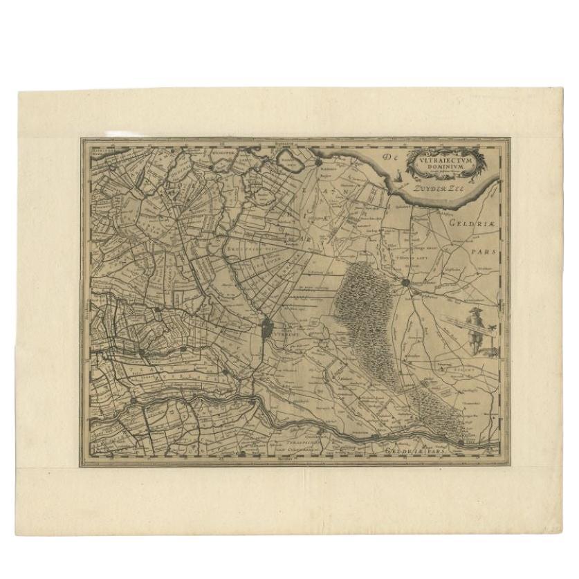
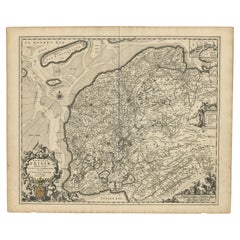
View AllOriginal Antique Map of Utrecht in the Netherlands by Blaeu, C.1645
Located in Langweer, NL
Antique map titled 'Ultraiectum Dominium'. Old map of the province of Utrecht, the Netherlands. This map originates from 'Theatrum Orbis Terrarum (..)'.
Artists and Engravers: Wi...
Category
Antique 17th Century Maps
Materials
Paper

$525 Sale Price
20% Off
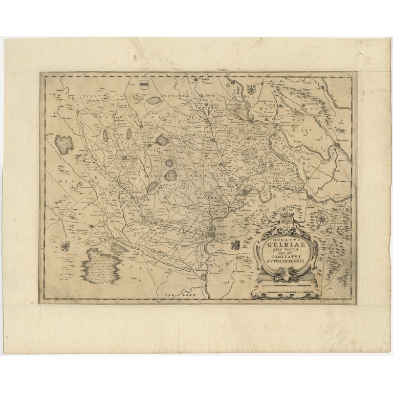
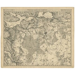
Antique Map of the Dutch Province of Gelderland with Zutphen as Capital, C.1650
Located in Langweer, NL
Antique map titled 'Ducatus Gelriae pars Tertia quae est comitatus Zutphaniensis'. Old map of the province of Gelderland, the Netherlands. The city of Zutphen can be found in the mid...
Category
Antique 17th Century Maps
Materials
Paper
$247 Sale Price
20% Off
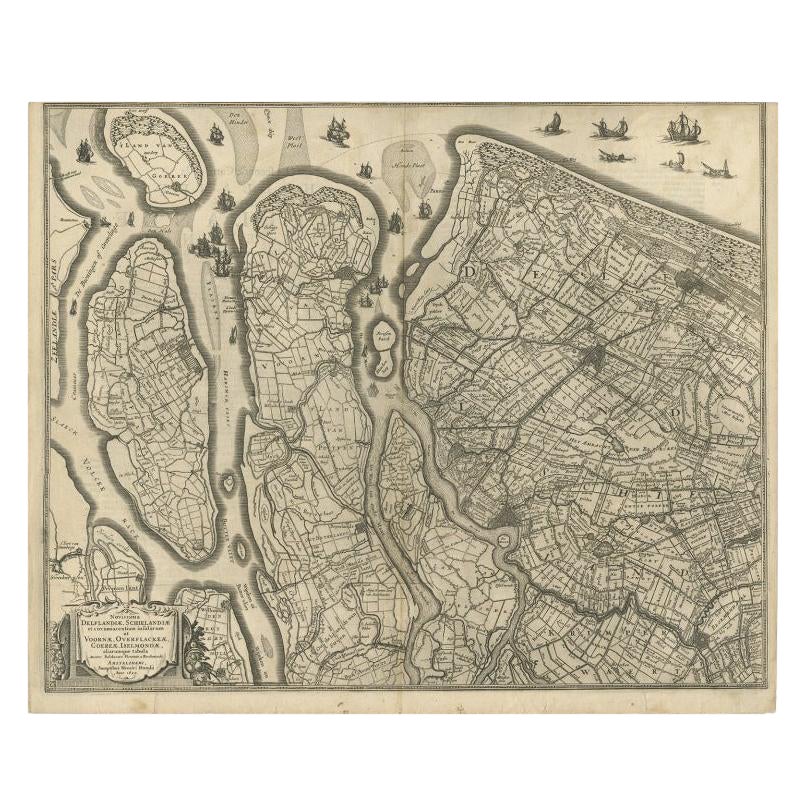
Antique Map of Delfland and Schieland by Hondius, c.1630
Located in Langweer, NL
Antique map titled ‘Novissima Delflandiae, Schielandiae et circumiacentium insularum ut Voornae, Overflackeae, Goereae, Iselmondae (..)’. Engraving of Delfland and Schieland. Designe...
Category
Antique 17th Century Maps
Materials
Paper
$788 Sale Price
20% Off
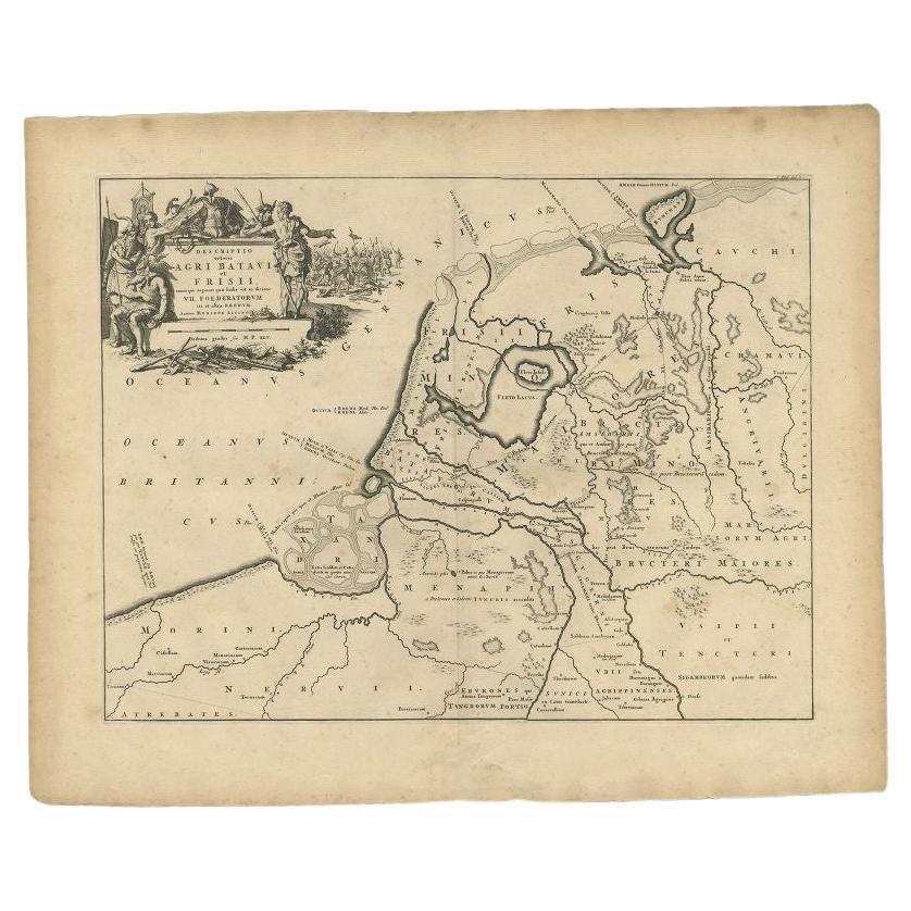
Antique Map of the Old Land of Batavia and FriesLand, The Netherlands, 1697
Located in Langweer, NL
Antique map Friesland titled 'Descriptio veteris Agri Batavi et Frisii (..)'. Old map of Friesland, the Netherlands. Depicts the old land of Batavia and Friesland. This map originate...
Category
Antique 17th Century Maps
Materials
Paper
$180 Sale Price
20% Off
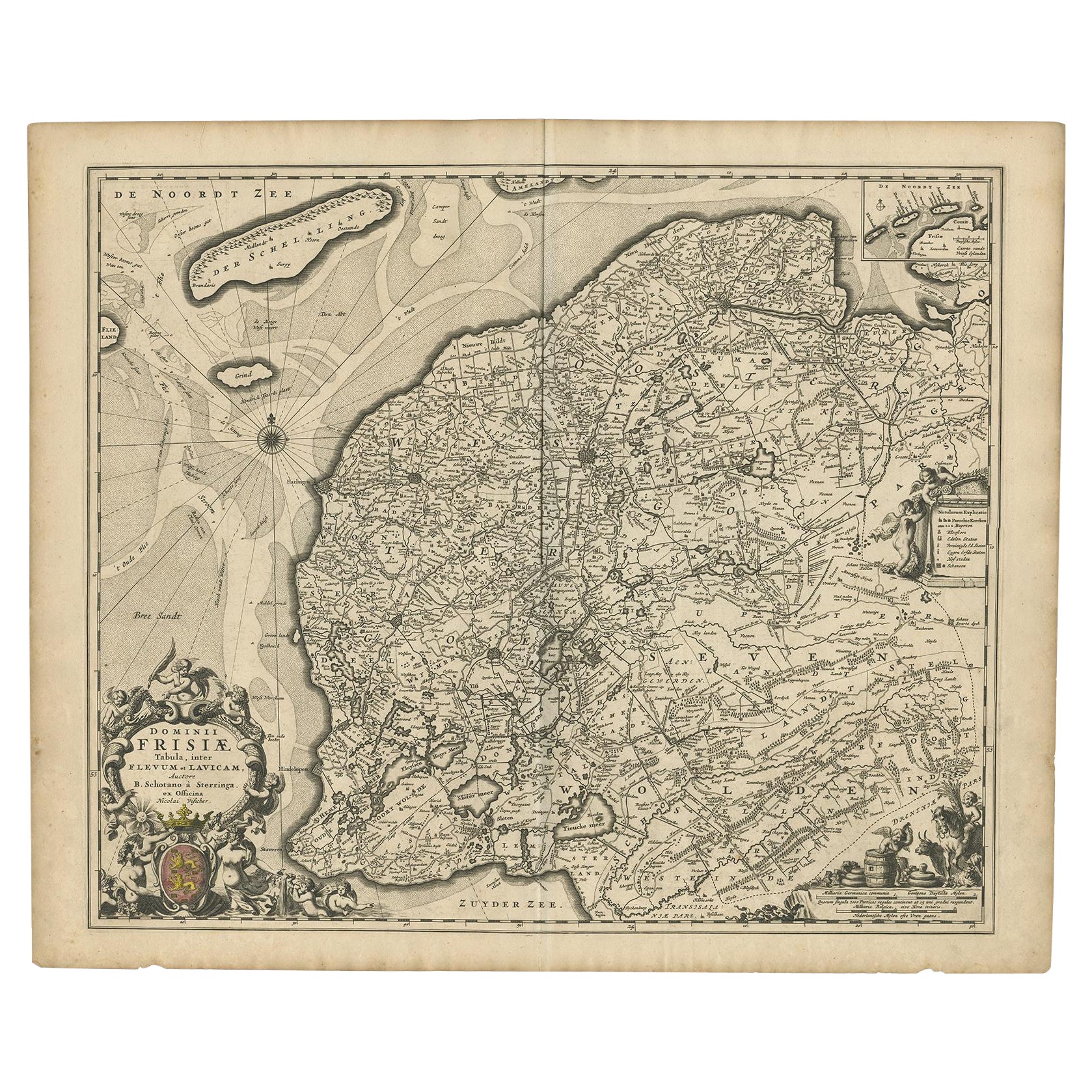
Beautiful First State Map of Friesland, the Netherlands, c.1665
Located in Langweer, NL
Antique map titled 'Dominii Frisiae Tabula, inter Flevum et Lavicam'. Beautiful first state map of Friesland, the Netherlands. With small inset map of the Frisian Wadden islands Vlie...
Category
Antique 17th Century Maps
Materials
Paper
$836 Sale Price
20% Off
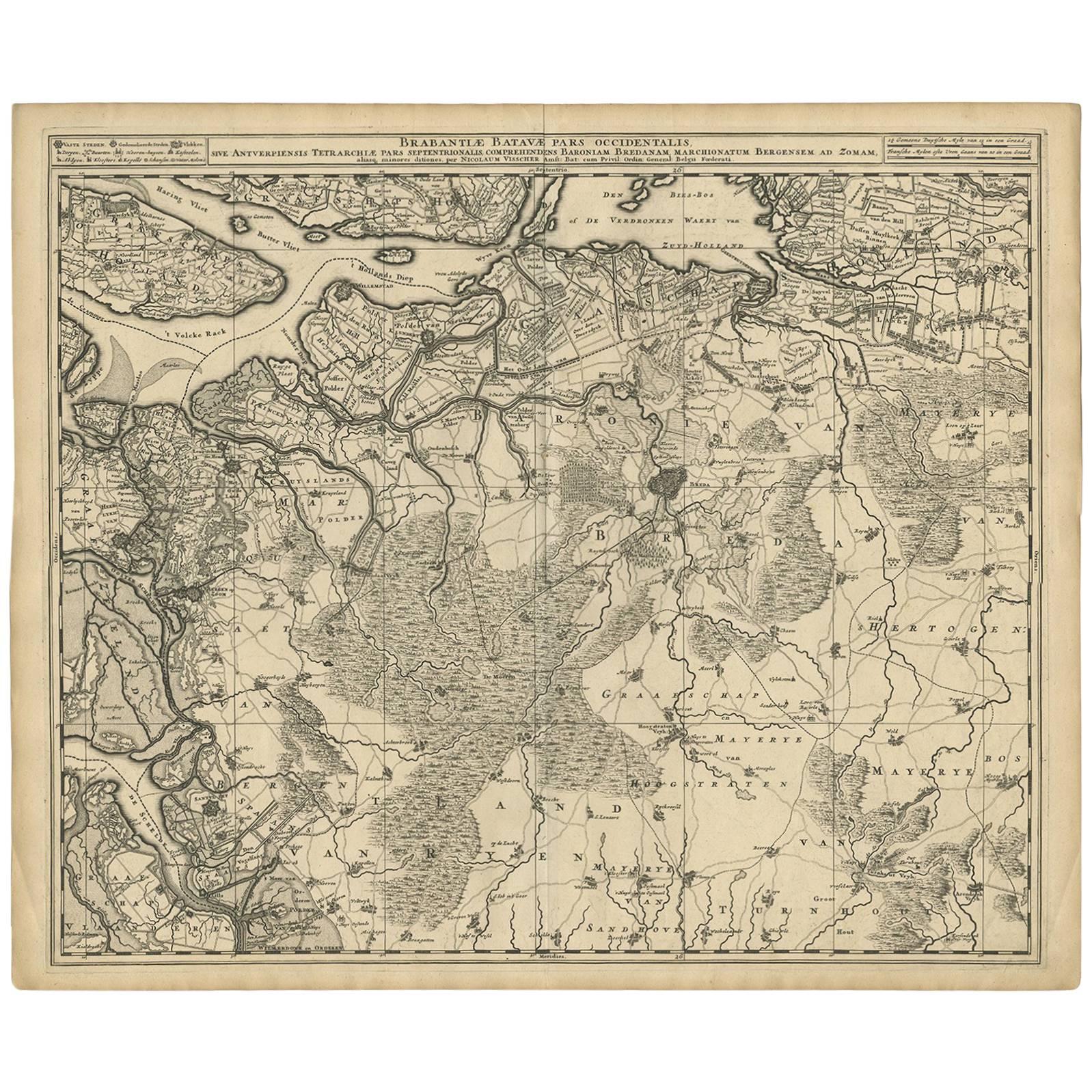
Antique Map of Brabant 'The Netherlands' by N. Visscher, circa 1690
Located in Langweer, NL
Antique map titled 'Brabantiae Batavae Pars Occidentalis (..)'. Highly detailed map of the region between Bergen Op Zoom, Breda, Hoogstraten and Sandvliet, The Netherlands. Published...
Category
Antique Late 17th Century Maps
Materials
Paper
$631 Sale Price
20% Off
You May Also Like
Rare Original Map of New Amsterdam (New York) – “Restitutio”, ca. 1674 –
Located in Dronten, NL
An exceptionally rare and original 17th-century engraving of New Amsterdam, now New York City, published by the renowned Amsterdam cartographer Carel (Carolus) Allard around 1674. Kn...
Category
Antique 17th Century Dutch Maps
Materials
Paper

1752 Vaugoundy Map of Flanders : Belgium, France, and the Netherlands, Ric.a002
Located in Norton, MA
Large Vaugoundy Map of Flanders:
Belgium, France, and the Netherlands
Colored -1752
Ric.a002
Description: This is a 1752 Didier Robert de Vaugondy map of Flanders. The map de...
Category
Antique 17th Century Unknown Maps
Materials
Paper

1643 Willem&Joan Blaeu Map NW Flanders "Flandriae Teutonicae Pars Prientalior
Located in Norton, MA
1643 Willem and Joan Blaeu map of northwest Flanders, entitled
"Flandriae Teutonicae Pars Prientalior,"
Ric0012
" Authentic" - Map of the northwest Fl...
Category
Antique 17th Century Dutch Maps
Materials
Paper

1635 Willem Blaeu Map of Northern France"Comitatvs Bellovacvm" Ric.a08
Located in Norton, MA
1635 Willem Blaeu map of northern France, entitled.
"Comitatvs Bellovacvm Vernacule Beavvais,"
Colored
Ric.a008
“COMITATVS BELLOVACVM…” Amsterdam: W...
Category
Antique 17th Century Unknown Maps
Materials
Paper

Utrecht, Netherlands: A Large 17th Century Hand-colored Map by Sanson & Jaillot
By Nicholas Sanson d'Abbeville
Located in Alamo, CA
This large hand-colored map entitled "La Seigneurie d'Utrecht. Dressé sur les memoires les plus nouveaux par le Sr. Sanson" was originally created by Nicholas Sanson d'Abbeville. Thi...
Category
1690s Landscape Prints
Materials
Engraving

1646 Jansson Map Entitled "Procinvia Connactiae, " Ric.a006
Located in Norton, MA
1646 Jansson map entitled
"Procinvia connactiae,"
Ric.a006
Description: The PROVINCE of CONNAVGT 490 x 380From vol 4 of Jansson's Atlas Novus 1646, published in Amsterdam with...
Category
Antique 17th Century Unknown Maps
Materials
Paper

More Ways To Browse
Charlotte Reine
Cleveland Antique Furniture
Gambia Antique Map
Johann Baptist Homann On Sale
Oman Map
Serbia Antique Map
Stanford Antique Furniture
Tipu Sultan
Used Office Furniture Cornwall
Vintage Wooden Roller
Albania Antique Map
Ancient Bible
Antique Bermuda Furniture
Antique Constellation Map
Antique Map Burgundy
Antique Map Of Hawaii
Antique Maps Of Long Island
Calcutta Map