Early 19th Century Maps
to
209
251
7
261
5
4
1
1
2,963
2,320
481
3
297
34
10
127
10
37
9
2
5
4
3
3
255
11
4
4
3
52
28
27
13
4
261
261
261
4
1
1
1
1
Period: Early 19th Century
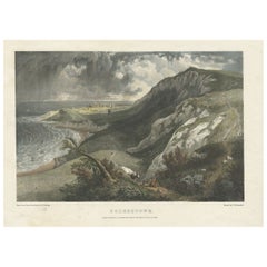
Hand-Colored Print of Folkestone 'United Kingdom' as Seen from the East, 1822
Located in Langweer, NL
Antique print titled 'Folkestone'.
This print depicts the town of Folkestone (United Kingdom) as seen from the East, the viewpoint high on the cliffs above the Warren, with cattl...
Category
Antique Early 19th Century Maps
Materials
Paper
$370 Sale Price
20% Off
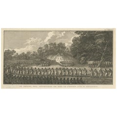
De Natsche – Ceremony for the King's Son, Tonga c.1795
Located in Langweer, NL
De Natsche – Ceremony for the King's Son, Tonga c.1795
This antique print depicts a grand ceremony held in honour of the son of the King of Tonga, known as the Natsche, in the villa...
Category
European Antique Early 19th Century Maps
Materials
Paper
$560 Sale Price
20% Off
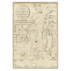
Antique Chart of the Straits of Makassar, Indonesia with Borneo and Celebes-1820
Located in Langweer, NL
Description: Antique map titled 'A New Chart of the Straits of Macassar with various additions & improvements by J.W. Norie'.
Rare and beautifully engraved chart of the Straits of Makassar showing Eastern Borneo and Celebes coast lines. With various smaller inset maps including a plan of the shoals off ragged and shoal points in Borneo, the Bay of Bonthain and the Straits of Salayr.
Artists and Engravers: John William Norie (1772-1843), acquired the chart publishing business of William Heather after he died in 1812. He went into partnership with George Wilson...
Category
Antique Early 19th Century Maps
Materials
Paper
$2,612 Sale Price
20% Off
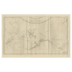
Old Map Showing the Tracks of Cook Between North America and Asia's Coast, 1803
Located in Langweer, NL
Description: Antique map titled 'Kaart van de Noord-West kust van Amerika en de Noord-Oost kust van Asia'.
Antique chart depicting America's northwest coast and Asia's northeast ...
Category
Antique Early 19th Century Maps
Materials
Paper
$902 Sale Price
20% Off
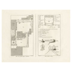
Engraving of a Chinese Garden in Canton and the Festival of Death in Macao, 1808
Located in Langweer, NL
Antique print titled 'Plan d'un Jardin Chinois à Quanton, Fête des Morts à Macao'.
Two images on one sheet depicting a Chinese garden and Festival of the Death in Macao. Originat...
Category
Antique Early 19th Century Maps
Materials
Paper
$399 Sale Price
20% Off
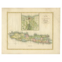
Antique Map of Java and Batavia of nowadays Indonesia, '1818'
Located in Langweer, NL
Antique map titled 'Kaart van het Eiland Java'. A rare and attractive early 19th century Dutch map of Java with a large inset map of Batavia. One of 12 maps from 'Atlas van Overzeesc...
Category
Antique Early 19th Century Maps
Materials
Paper
$1,140 Sale Price
20% Off
Antique Map of China by Wilkinson '1803'
Located in Langweer, NL
Antique map titled 'China, Contains 15 Subject Provinces Including the 2 Islands of Hainan, Formosa and the Tributary Kingdoms of Korea, Tonkin'. Old map depicting China, extending f...
Category
Antique Early 19th Century Maps
Materials
Paper
$285 Sale Price
20% Off
Antique Map of Borneo and Malaysia by P.M.G. Vandermaelen, 1827
Located in Langweer, NL
A chart of the north western part of Borneo and Malaysia (Sarawak). Published by P.M.G. Vandermaelen, 1827.
Category
Antique Early 19th Century Maps
Materials
Paper
$536 Sale Price
20% Off
Antique Map of South Sumatra by P.M.G. Vandermaelen, 1827
Located in Langweer, NL
A chart showing the southern part of Sumatra, the island of Belitung and southern Borneo, published in the "Atlas Universel de Géographie".
Category
Antique Early 19th Century Maps
Materials
Paper
$470 Sale Price
20% Off
Antique Map of France by Van Baarsel (c.1820)
Located in Langweer, NL
'Frankrijk naar de nieuwste bepalingen meerendeels gevolgd naar Lapie'. Beautiful map of France with an inset map of the island of Corsica. Includes a table with reference to the dep...
Category
Dutch Antique Early 19th Century Maps
Materials
Paper
Antique Map of the British Islands by J. Thomson, 1817
Located in Langweer, NL
Group of 5 maps of the Channel Islands, Scilly, Jersey, the Isle of Mann and the Isle of Wight. Engraved views of the Eddystone Lighthouse and Freshwater Bay on the Isle of Wight, wi...
Category
Antique Early 19th Century Maps
Materials
Paper
Early 19th Century Hand Colored Map of the United States and Caribbean Islands
Located in Hamilton, Ontario
Hand coloured early 19th century map by Giraldon of France titled "Etats Unis et Grandes Antilles" (United States and Greater Antilles).
Category
French Antique Early 19th Century Maps
Materials
Paper
$595 Sale Price
40% Off
Antique Lithography Map, Worcestershire, English, Framed Engraving, Cartography
Located in Hele, Devon, GB
This is an antique lithography map of Worcestershire. An English, framed atlas engraving of cartographic interest, dating to the early 19th centur...
Category
British Regency Antique Early 19th Century Maps
Materials
Wood
Old Horizontal Map of England
By Tasso
Located in Alessandria, Piemonte
ST/520 - Old rare Italian map of England, dated 1826-1827 - by Girolamo Tasso, editor in Venise, for the atlas of M.r Le-Sage.
Category
Italian Other Antique Early 19th Century Maps
Materials
Paper
Curaçao map - C. van Baarsel en zoon
Located in UTRECHT, UT
“Kaart van het eiland Curaçao.”, “Algemeene kaart der Caraïbische eilanden”, “Plan van het fort Amsterdam op Curaçao” from the atlas “Atlas der overzeesche bezittingen van Zijne Maje...
Category
Dutch Other Antique Early 19th Century Maps
Materials
Paper
Map Hanging Wall County of Devon C&J Greenwood 1827 Exeter Cathedral Lundy Isle
Located in BUNGAY, SUFFOLK
C & J GREENWOOD MAP OF THE COUNTY OF DEVON, FROM AN ORIGINAL SURVEY, PUBLISHED 1827, WITH ENGRAVING OF EXETER CATHEDRAL AND MAP OF LUNDY INSET, 6ft 2 ...
Category
English Early Victorian Antique Early 19th Century Maps
Materials
Paper
Staffordshire 1645 Hand Colored Antique Print Staffordiensis Comitatvs Map
Located in West Sussex, Pulborough
We are delighted to offer for sale this lovely antique Atlas page map of Staffordshire printed in 1645 Amsterdam Staffordiensis Comitatvs Vulgo
This o...
Category
English Georgian Antique Early 19th Century Maps
Materials
Paper
$434 Sale Price
30% Off
Double Sided and Glazed Cheshire 1645 Hand Colored Antique Print Map Rare Find
Located in West Sussex, Pulborough
We are delighted to offer for sale this lovely antique Atlas page map of Cheshire printed in 1645 Amsterdam Staffordiensis Comitatvs Vulgo
I have thre...
Category
English Georgian Antique Early 19th Century Maps
Materials
Paper
$434 Sale Price
30% Off
Antique Framed Pen and Ink on Fabric Map of Cornwall from Early 19th Century
Located in Los Angeles, CA
This English fabric map of Cornwall, rendered in pen-and-ink, showcases exquisite hand-drawn details and charming faded sepia tones. Encased in a classic frame, this piece elegantly ...
Category
English Antique Early 19th Century Maps
Materials
Walnut, Fabric
Pair of Fine Desk Globes by J. Cary, 1816 and 1824
Located in Amsterdam, NL
A pair of desk globes by J. Cary
“Cary’s New Terrestrial Globe delineated from the best Authorities extant; exhibiting the late discoveries toward the North Pole and every improve...
Category
Antique Early 19th Century Maps
Materials
Other
$29,689 / set
Double Sided Northamptonshire 1645 Hand Colored Antique Print Map Rare Find
Located in West Sussex, Pulborough
We are delighted to this lovely antique Atlas page map of Northamptonshire printed in 1645 Amsterdam Staffordiensis Comitatvs Vulgo
I have three of th...
Category
English Georgian Antique Early 19th Century Maps
Materials
Paper
$434 Sale Price
30% Off
