Items Similar to Remarkable Map of the Alsace Region and Nova Zembla, Russia, ca.1700


Want more images or videos?
Request additional images or videos from the seller
1 of 5
Remarkable Map of the Alsace Region and Nova Zembla, Russia, ca.1700
$379.99
$583.6834% Off
£284.55
£437.0834% Off
€319
€49034% Off
CA$529.58
CA$813.4734% Off
A$580.82
A$892.1834% Off
CHF 303.76
CHF 466.5934% Off
MX$7,017.96
MX$10,779.9334% Off
NOK 3,811.31
NOK 5,854.3634% Off
SEK 3,592.62
SEK 5,518.4434% Off
DKK 2,428.48
DKK 3,730.2634% Off
About the Item
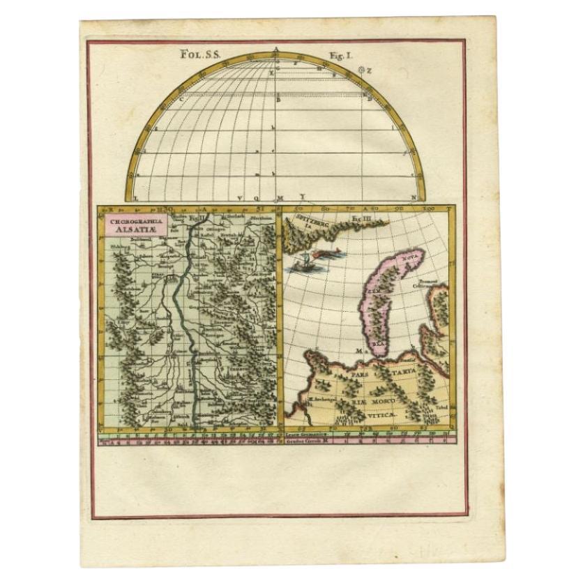
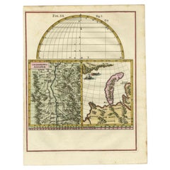
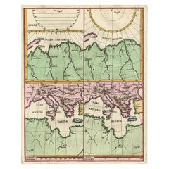
Antique map titled 'Chorographia Alsatiae.'
Map of the Alsace region and Nova Zembla, printed for Scherer's 'Atlas Novus' (1702-1710). Scherer's 'Atlas Novus' forms an important milestone in the development of scientific and thematic cartography, providing a remarkable and revolutionary alternative vision of the World in showing only its major physical and topographical features.
Artists and Engravers: Heinrich Scherer (1628-1704) was a Professor of Hebrew, Mathematics and Ethics at the University of Dillingen until about 1680. Thereafter he obtained important positions as Official Tutor to the Royal Princes of Mantua and Bavaria. It was during his time in Munich as Tutor to the Princely house of Bavaria that his lifetime’s work as a cartographer received acclaim and recognition. Scherer’s world atlas, the Atlas Novus, first published in Munich between 1702 and 1710 and reissued in a second edition between 1730 and 1737, forms a singularly unusual, almost revolutionary work in terms of the development of European mapmaking at the beginning of the 18th Century.
Condition: Good, given age. Light damp stain top left, barely affecting image. General age-related toning and/or occasional minor defects from handling. Please study image carefully.
- Dimensions:Height: 10.63 in (27 cm)Width: 8.27 in (21 cm)Depth: 0 in (0.02 mm)
- Materials and Techniques:
- Period:1700-1709
- Date of Manufacture:circa 1700
- Condition:Condition: Good, given age. Light damp stain top left, barely affecting image. General age-related toning and/or occasional minor defects from handling. Please study image carefully.
- Seller Location:Langweer, NL
- Reference Number:Seller: PCT-61592 1stDibs: LU3054326831912
About the Seller
5.0
Recognized Seller
These prestigious sellers are industry leaders and represent the highest echelon for item quality and design.
Platinum Seller
Premium sellers with a 4.7+ rating and 24-hour response times
Established in 2009
1stDibs seller since 2017
2,653 sales on 1stDibs
Typical response time: <1 hour
- ShippingRetrieving quote...Shipping from: Langweer, Netherlands
- Return Policy
Authenticity Guarantee
In the unlikely event there’s an issue with an item’s authenticity, contact us within 1 year for a full refund. DetailsMoney-Back Guarantee
If your item is not as described, is damaged in transit, or does not arrive, contact us within 7 days for a full refund. Details24-Hour Cancellation
You have a 24-hour grace period in which to reconsider your purchase, with no questions asked.Vetted Professional Sellers
Our world-class sellers must adhere to strict standards for service and quality, maintaining the integrity of our listings.Price-Match Guarantee
If you find that a seller listed the same item for a lower price elsewhere, we’ll match it.Trusted Global Delivery
Our best-in-class carrier network provides specialized shipping options worldwide, including custom delivery.More From This Seller
View AllAntique Map of the Alsace region and Nova Zembla by Scherer, c.1700
Located in Langweer, NL
Antique map titled 'Chorographia Alsatiae.' Map of the Alsace region and Nova Zembla, printed for Scherer's 'Atlas Novus' (1702-1710). Scherer's 'Atlas Novus' forms an important mile...
Category
Antique 18th Century Maps
Materials
Paper
$142 Sale Price
20% Off
Antique Map of Nova Zembla ‘Russia’ by J.N. Bellin, 1758
Located in Langweer, NL
An interesting map of Nova Zembla and surrounding areas. With details on the eastern tip of Nova Zembla of the place where the stranded Dutch sailors under Willem Barentsz spent the ...
Category
Antique Mid-18th Century Maps
Materials
Paper

$228 Sale Price
20% Off
Map of the Duchy of Pomerania – Antique Engraving by P. Schenk Jr., c. 1750
Located in Langweer, NL
Map of the Duchy of Pomerania – Antique Engraving by P. Schenk Jr., c. 1750
Antique map titled 'Ducatus Pomeraniae Tabula Generalis'. This historical map presents the Duchy of Pomer...
Category
Antique Mid-18th Century Dutch Maps
Materials
Paper

$476 Sale Price
20% Off
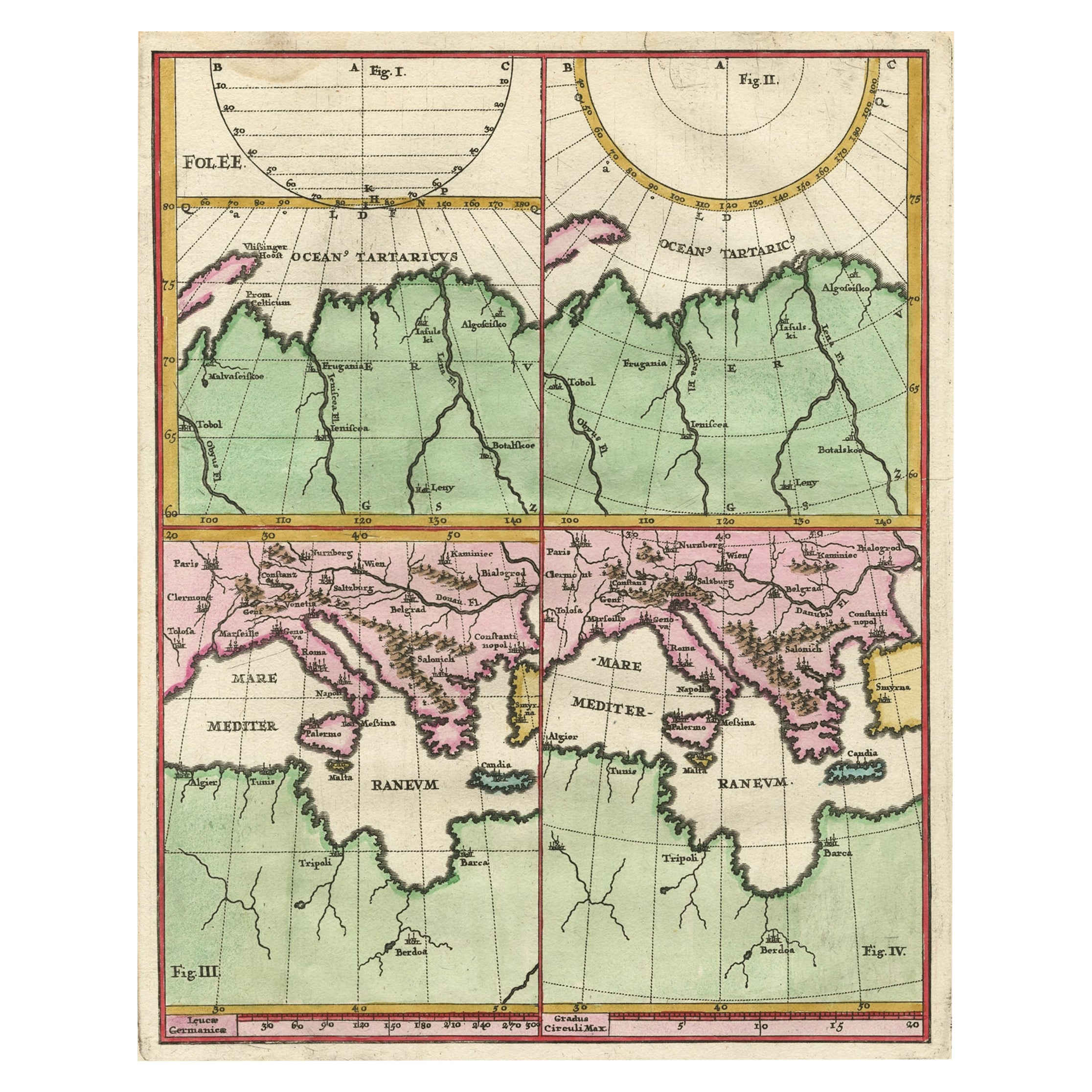
Curious Map of the Laptev Sea 'Arctic Ocean' and the Mediterranean, ca.1700
Located in Langweer, NL
Antique map, untitled.
Map of the Laptev Sea (Arctic Ocean) and the Mediterranean, printed for Scherer's 'Atlas Novus' (1702-1710). Scherer's 'Atlas Novus' forms an important mil...
Category
Antique Early 1700s Maps
Materials
Paper
$447 Sale Price
20% Off
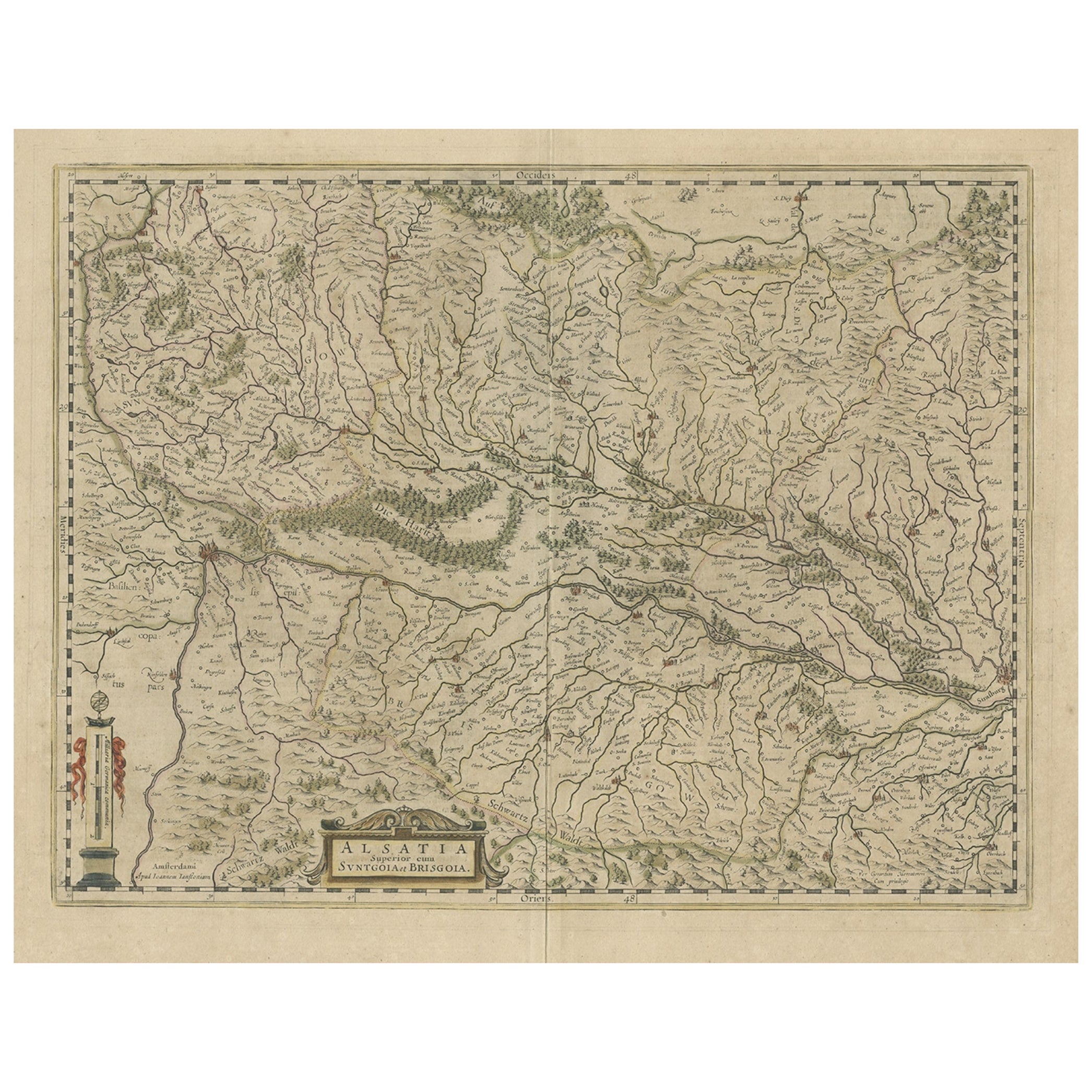
Old Map of the Alsace 'Elzas' Region with Lotharingen 'Lorraine', France, c1650
Located in Langweer, NL
Antique map titled 'Alsatia superior cum Suntgoia et Brisgoia'.
Old map of the Alsace (or Elzas) region with Lotharingen (Lorraine), Strassburg, Freiburg, Basel etc. Source unkno...
Category
Antique 1650s Maps
Materials
Paper
$419 Sale Price
20% Off
Antique Map of European Russia by Tirion, c.1725
Located in Langweer, NL
Antique map titled 'Nieuwe Kaart van Muskovie of Rusland na de laatste ondekking int licht gebracht te Amsterdam by Isaak Tirion'. Detailed map of European Russia.
Artists and En...
Category
Antique 18th Century Maps
Materials
Paper

$905 Sale Price
20% Off
You May Also Like
17th Century Nicolas Visscher Map of Southeastern Europe
Located in Hamilton, Ontario
A beautiful, highly detailed map of southeastern Europe by Nicolas Visscher. Includes regions of Northern Italy (showing the cities Bologna, Padua, and Venice), Bohemia, Austria (sho...
Category
Antique 17th Century Dutch Maps
Materials
Paper

$1,350 Sale Price
38% Off
1714 Henri Chatelain "Nouvelle Carte Des Etatas Du Grand.Duc De Mos Moscovie Eur
Located in Norton, MA
A 1714 Henri Chatelain map, entitled
"Nouvelle Carte Des Etatas Du Grand Duc De Moscovie En Europe,"
Ricb001
Henri Abraham Chatelain (1684-1743) was a Huguenot pastor of Parisi...
Category
Antique Early 18th Century Dutch Maps
Materials
Paper

1790 Thomas Stackhouse Map, Entitled "Russia in Europe, " , Ric.a004
Located in Norton, MA
1790 Thomas Stackhouse map, entitled
"Russia in Europe"
Ric.a004
Stackhouse, Thomas
Russia in Europe [map]
London: T. Stackhouse, 1783. Map. Matted hand-colored copper engraving. Image size: 14.5 x 15.25 inches. Mat size: 22.75 x 23.75 inches. A beautiful example of this map of Eastern Europe...
Category
Antique 17th Century Unknown Maps
Materials
Paper

Original Antique Map of Switzerland, Engraved By Barlow, Dated 1807
Located in St Annes, Lancashire
Great map of Switzerland
Copper-plate engraving by Barlow
Published by Brightly & Kinnersly, Bungay, Suffolk.
Dated 1807
Unframed.
Category
Antique Early 1800s English Maps
Materials
Paper

1646 Jansson Map Entitled "Procinvia Connactiae, " Ric.a006
Located in Norton, MA
1646 Jansson map entitled
"Procinvia connactiae,"
Ric.a006
Description: The PROVINCE of CONNAVGT 490 x 380From vol 4 of Jansson's Atlas Novus 1646, published in Amsterdam with...
Category
Antique 17th Century Unknown Maps
Materials
Paper

1656 Jansson Map Metz Region of France Entitled "Territorium Metense" Ric0014
Located in Norton, MA
1656 Jansson map Metz Region of France entitled "Territorium Metense."
Ric0014
" Authentic" - Map of the historical region surrounding Metz, in Lorraine, France.
Oriented with ...
Category
Antique 17th Century Dutch Maps
Materials
Paper

More Ways To Browse
Royal Prince
1700 Antique Furniture
Tennessee Antique Furniture
Used Furniture Alabama
Used Office Furniture Maine
Ancient World Map
Antique Florida Map
Antique Map Chile
Antique Map Of Georgia
Antique Mississippi Furniture
Burgundy Map
John Speed Antique Maps
Malabar Map
Malaysia Map
Map Of Syria
Taiwan Map
Antique Chicago Maps
Dutch Bible