Items Similar to Scarce U.S. Coast Survey Map Depicting Entrance to San Francisco Bay Dated 1856


Want more images or videos?
Request additional images or videos from the seller
1 of 12
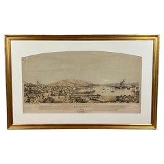
Scarce U.S. Coast Survey Map Depicting Entrance to San Francisco Bay Dated 1856
$975
£739.18
€852.08
CA$1,373.13
A$1,522.70
CHF 800.07
MX$18,604.82
NOK 10,009.92
SEK 9,396.02
DKK 6,360.97
About the Item
A fine example of the 1856 U.S. Coast lithographic survey nautical chart of the entrance to San Francisco bay and the city. Published in 1856 by the Office of the Coast Survey the official chart maker of the United States.
An interesting and visually attractive historical document by Alexander Bache. Custom framed and glazed. Framed dimensions: H. 28" W. 46".
- Dimensions:Height: 28 in (71.12 cm)Width: 46 in (116.84 cm)Depth: 1.5 in (3.81 cm)
- Materials and Techniques:
- Place of Origin:
- Period:
- Date of Manufacture:1856
- Condition:Wear consistent with age and use. Now framed. Some toning as shown in pictures.
- Seller Location:San Francisco, CA
- Reference Number:Seller: C923-41stDibs: LU855236183902
About the Seller
5.0
Recognized Seller
These prestigious sellers are industry leaders and represent the highest echelon for item quality and design.
Platinum Seller
Premium sellers with a 4.7+ rating and 24-hour response times
Established in 1982
1stDibs seller since 2008
361 sales on 1stDibs
Typical response time: <1 hour
Associations
The Art and Antique Dealers League of AmericaAntiques Associations Members
- ShippingRetrieving quote...Shipping from: San Francisco, CA
- Return Policy
Authenticity Guarantee
In the unlikely event there’s an issue with an item’s authenticity, contact us within 1 year for a full refund. DetailsMoney-Back Guarantee
If your item is not as described, is damaged in transit, or does not arrive, contact us within 7 days for a full refund. Details24-Hour Cancellation
You have a 24-hour grace period in which to reconsider your purchase, with no questions asked.Vetted Professional Sellers
Our world-class sellers must adhere to strict standards for service and quality, maintaining the integrity of our listings.Price-Match Guarantee
If you find that a seller listed the same item for a lower price elsewhere, we’ll match it.Trusted Global Delivery
Our best-in-class carrier network provides specialized shipping options worldwide, including custom delivery.More From This Seller
View AllEarly San Francisco View by Henry Firks Printed by W.H. Jones in 1849
Located in San Francisco, CA
A tinted lithographic view of San Francisco, made during the gold rush, showing a panoramic view of the bay's waterfront from the south along Montgomery Street to Telegraph Hill. The...
Category
Antique Mid-19th Century American Victorian Maps
Materials
Paper
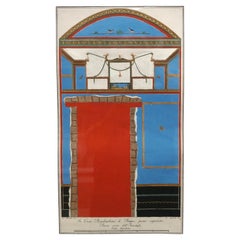
Early Nineteenth Century Colored Etching of a Wall in Pompeii
Located in San Francisco, CA
A framed architectural engraving of a wall in Pompeii titled "In Casa Pseudourbana Di Pompei piano superiore Parete corta dell'antistuf...
Category
Antique Early 19th Century Italian Neoclassical Prints
Materials
Paper
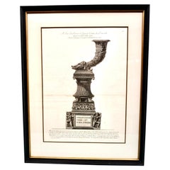
Original Piranesi Framed Engraving of a Monument in the Form of a Cornucopia
By Giovanni Battista Piranesi
Located in San Francisco, CA
Giovanni Battista Piranesi, Italian 1720-1778) Engraving on wove paper depicting an ancient Roman funeral monument in the form of a cornucopia from the Via...
Category
Antique Early 19th Century French Neoclassical Prints
Materials
Paper
The Korean Embassy Wood Engraving from The Wasp
Located in San Francisco, CA
An interesting depiction of the Korean Embassy as published in The Wasp, a weekly San Francisco newspaper started in 1876 by Francis Korbel. The Wasp had a very political and anti-im...
Category
Antique Late 19th Century American Victorian Prints
Materials
Paper

Pompeiana; The Topography, Edifices, and Ornaments of Pompeii Sir Wm. Gell 1837
Located in San Francisco, CA
Pompeiana The Topography, Edifices and Ornaments of Pompeii by Sir William Gell, complete in two 1/4 leather tall octavo volumes with marbleized boards. 82 full page engraved plates ...
Category
Antique 1830s English Books
Materials
Leather, Paper

Pair of English Watercolors of Naval Battles by Irwin Bevans in Giltwood Frames
Located in San Francisco, CA
Irwin John David Bevan (English 1852-1940)
A dramatic pair of English watercolors on paper depicting naval battles. The paintings are inscribed on the versos as follows:
The first: ...
Category
Antique Late 19th Century English Georgian Paintings
Materials
Paper

You May Also Like
Large U.S. Coast and Geodetic Survey Chart A of the Atlantic Coast, 1877
Located in Nantucket, MA
Large U.S. Coast and Geodetic Survey Chart A of the Atlantic Coast, 1877, re-issued in February 1881, a printed paper laid down on linen navigational chart of the U.S. Atlantic coast...
Category
Antique 1880s American Other Maps
Materials
Linen

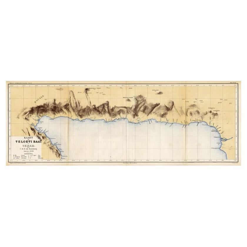
Antique Map of Taluti Bay by Stemler, C.1875
Located in Langweer, NL
Antique map titled 'Kaart der Teloeti Baai op Ceram.' This scarce map shows the Taluti Bay on the Moluccan island of Ceram. Originates from 'Tijdschrift Aardrijkskundig Genootschap',...
Category
Antique 19th Century Maps
Materials
Paper

$117 Sale Price
20% Off
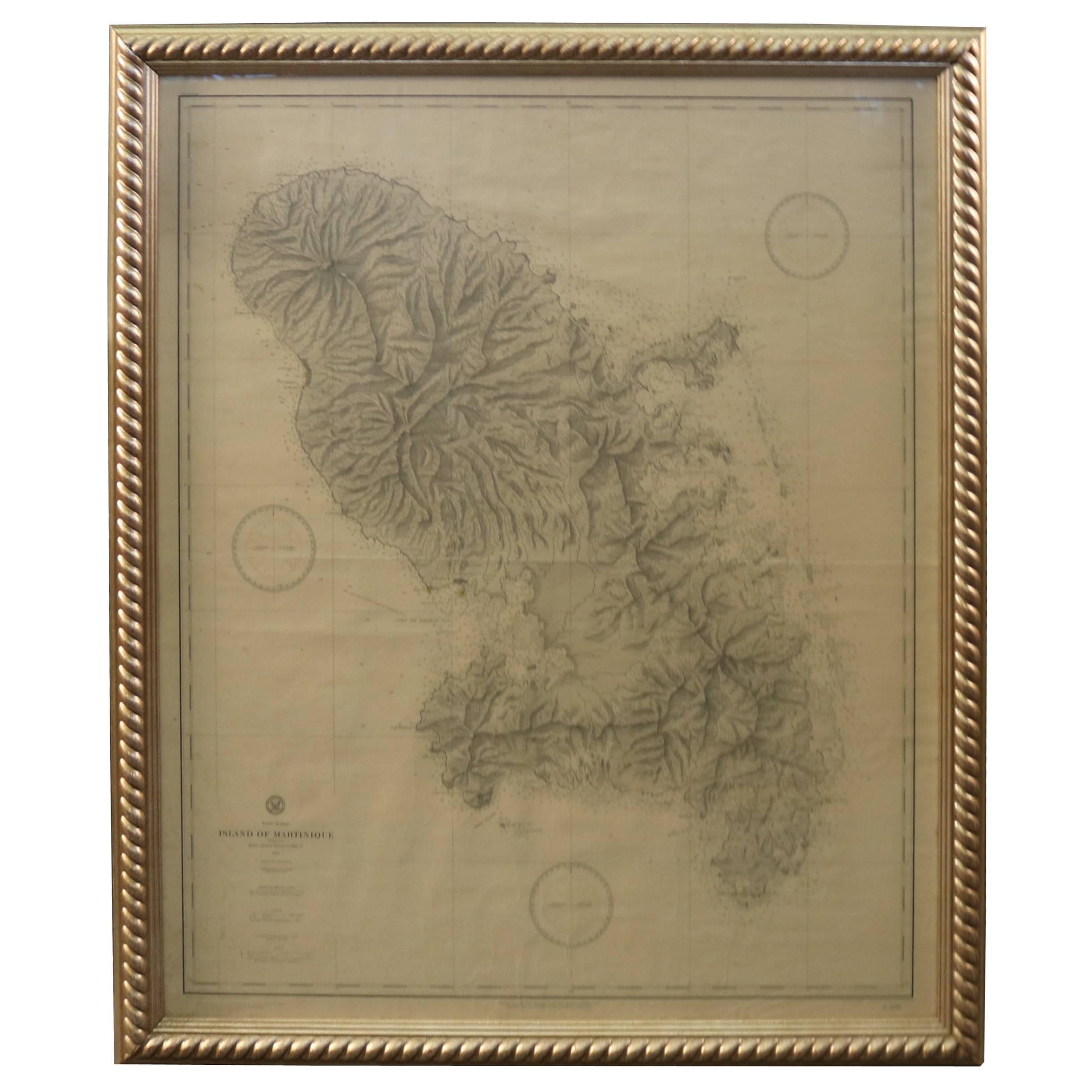
19th Century Nautical Chart of Martinique
Located in Norwell, MA
Original map of Martinique from 1887 with chartered waters around the island. Prepared from a French survey, completed in 1825, showing town, ports, rivers and tributaries. Published...
Category
Antique 19th Century Nautical Objects

Antique Maritime Chart of East Coast Virginia to Nova Scotia
Located in Norwell, MA
1920 nautical chart of the East Coast of the United States from Virginia to Maine, New Brunswick, and Nova Scotia. The chart shows Cape Cod, Long Island, the Connecticut coast, Jersey Shore, Maine, New Hampshire, etc. Very detailed, showing ports, lighthouses, shoals, depths, etc. The chart is by famous cartographer George W. Eldridge, compiled from surveys of the United States government, British Admiralty, George Eldridge, and others. First authorized by George Eldridge, published in 1916 by Wilfred O. White with a merchant's stamp of Charles Hutchinson...
Category
Vintage 1920s North American Maps
Materials
Paper

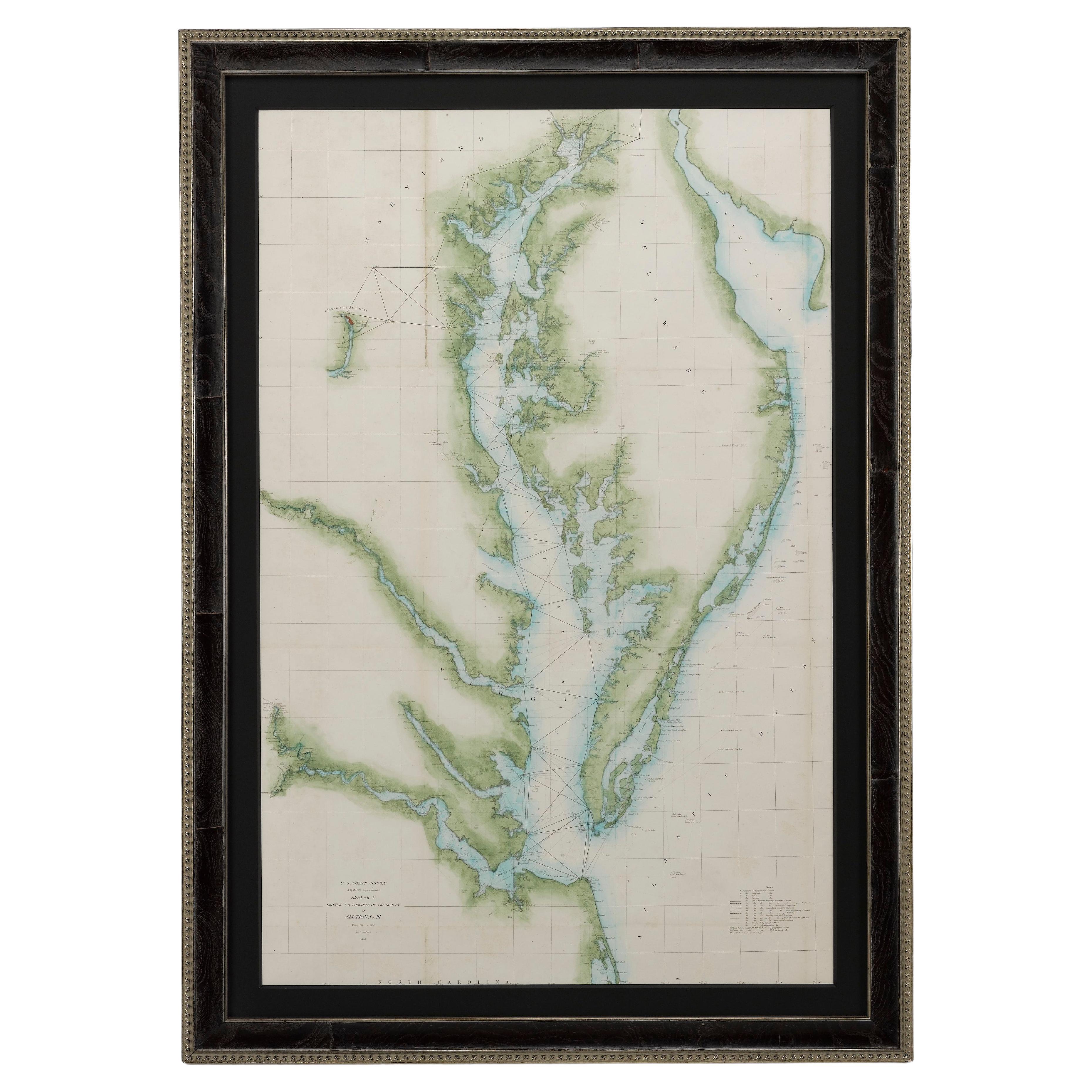
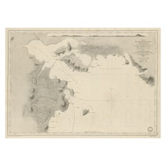
1856 U.S. Coast Survey Map of Chesapeake Bay and Delaware Bay
Located in Colorado Springs, CO
Presented is U.S. Coast Survey nautical chart or maritime map of Chesapeake Bay and Delaware Bay from 1856. The map depicts the region from Susquehanna, Maryland to the northern Outer Banks in North Carolina. It also shows from Richmond and Petersburg, Virginia to the Atlantic Ocean. The map is highly detailed with many cities and towns labeled throughout. Rivers, inlets, and bays are also labeled. Various charts illustrating more specific parts of the region are marked on the map using dotted lines. The lines form boxes, and the corresponding chart number and publication date are given. Extensive triangulation surveys were conducted the length of Chesapeake Bay and are illustrated here. Hampton Roads, Virginia is labeled, along with the James, York, and Rappahannock Rivers, which were all extensively surveyed.
The chart was published under the supervision of A. D. Bache, one of the most influential and prolific figures in the early history of the U.S. Coast Survey, for the 1856 Report of the Superintendent of the U.S. Coast Survey. Alexander Dallas Bache (1806-1867) was an American physicist, scientist, and surveyor. Bache served as the Superintendent of the U.S. Coast Survey from 1843 to 1865. Born in Philadelphia, Bache toured Europe and composed an important treatise on European Education. He also served as president of Philadelphia's Central High School and was a professor of natural history and chemistry at the University of Pennsylvania. Upon the death of Ferdinand Rudolph Hassler, Bache was appointed Superintendent of the United States Coast Survey.
The Office of the Coast Survey, founded in 1807 by President Thomas Jefferson and Secretary of Commerce Albert Gallatin...
Category
Antique 1850s American Maps
Materials
Paper

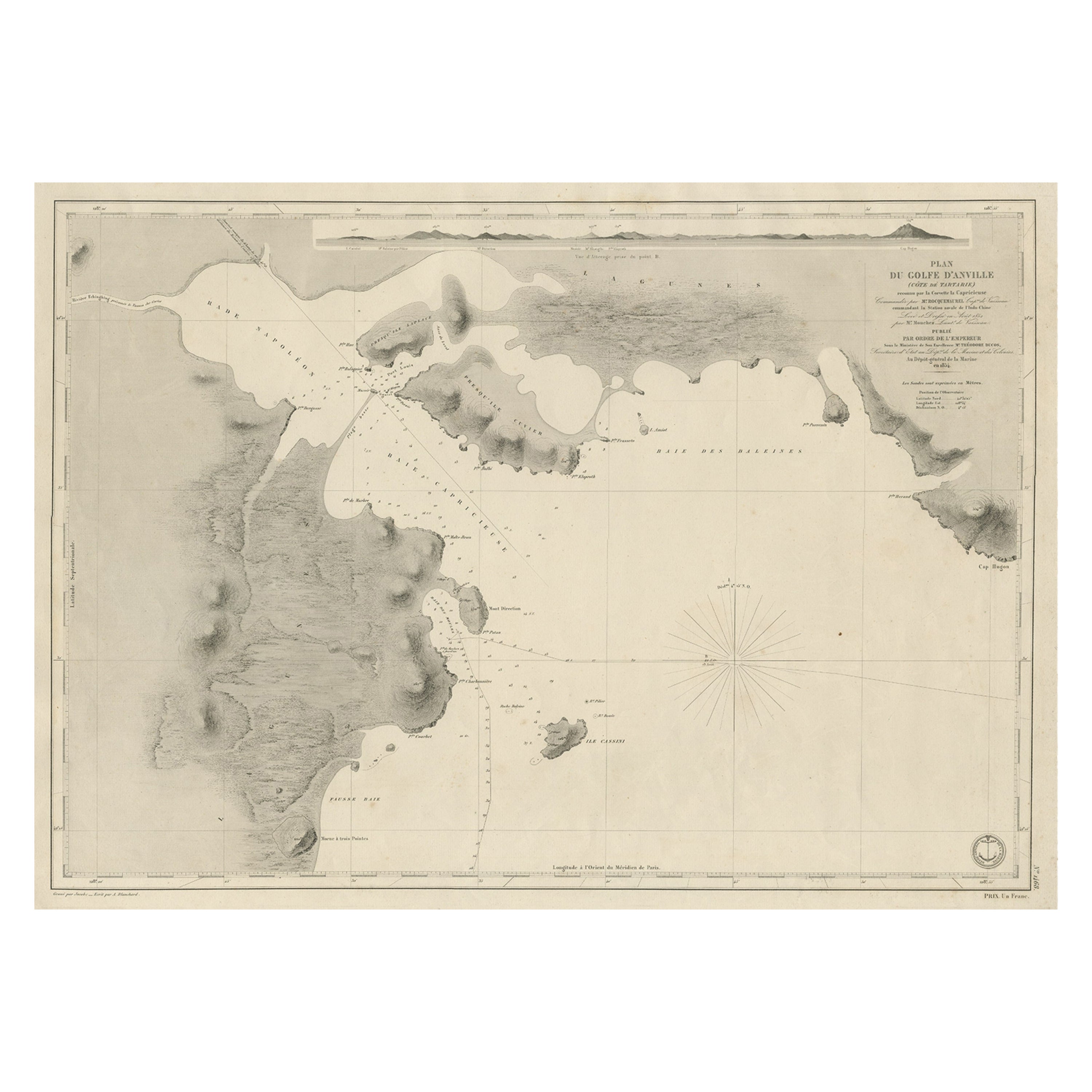
Antique Map of Part of the Chinese Coast, Explored by the French, Ca.1852
Located in Langweer, NL
Antique map titled 'Plan du Golfe D'Anville (Côte de Tartarie)'.
Old map of part of the Chinese coast, explored with the French corvette 'Caprieuse'. The Capricieuse was a late 2...
Category
Antique 1850s Maps
Materials
Paper
$658 Sale Price
34% Off
More Ways To Browse
San Francisco Used Furniture
Historical Documents
Antique Rug Wool Navy Blue Red
Antique Silver Platter
Boat Blueprint
Cream Plates
Vintage Art Deco Rugs
Vintage Serving Forks
Brewery Signs
Herati Rug
Gold Leaf Furniture Black
Italian Wood Console Tables
Maison Jansen Argentina
Antique Oushak
Mid Century Danish Directors Chairs
Moller 70
Wood Relief Art
Argentina Travel Poster