Items Similar to Striking Antique Map Centered on the Malay Peninsula


Want more images or videos?
Request additional images or videos from the seller
1 of 7
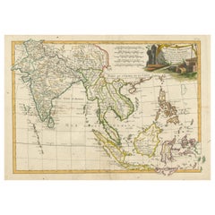
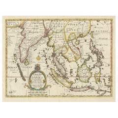
Striking Antique Map Centered on the Malay Peninsula
$1,151.94
$1,439.9220% Off
£849.51
£1,061.8920% Off
€960
€1,20020% Off
CA$1,590.81
CA$1,988.5220% Off
A$1,745.50
A$2,181.8820% Off
CHF 913.51
CHF 1,141.8920% Off
MX$21,481.21
MX$26,851.5120% Off
NOK 11,508.91
NOK 14,386.1420% Off
SEK 10,779.81
SEK 13,474.7620% Off
DKK 7,311.58
DKK 9,139.4720% Off
About the Item
Antique map titled 'D'Indiaanze Landschappen Zeen en Eylanden, van Couchin af tot in de Moluccos (...)'. Striking map of the region from the Philippines and Formosa to India and the Maldives, centered on the Malay Peninsula. The map was used to illustrate the Dutch Translation of the Account of Nuno da Cunha in the region. Nuno da Cunha was a governor of the Portuguese possessions in India from 1528 to 1538. He was the son of the famous Portuguese navigator, admiral and ambassador to Pope Leo X, Tristão da Cunha, and Tristão's wife Antónia Pais. Nuno da Cunha fought in battles at Oja and Brava, and at the capture of Panane, under the viceroy Francisco de Almeida. Named by João III ninth governor of Portuguese possessions in India, he served from April 1528 to 1538. On his passage to Goa, he subdued the pirates at Mombassa who had been harassing the coast of Mozambique. Nuno's brothers Pero Vaz da Cunha and Simão da Cunha were expected to serve under him as second and third in command, a form of nepotism that was expected in the Portuguese Estado da Índia. However, they died on the voyage, and Nuno was forced to rely upon local networks of clientage in Goa during his long rule. In 1529, Nuno sent an expedition that sacked and burned the city of Damão on the Arabian Sea at the mouth of the Damão River, about 100 miles north of Mumbai in the Muslim state of Gujarat. Forces under his control captured Baxay (now Vasai, often mistaken for Basra in Iraq) from the Muslim ruler of Gujarat, Bahadur Shah, on January 20, 1533. The next year, renamed Bassein, the city became the capital of the Portuguese province of the North, and the great citadel of black basalt, still standing, was begun. (It was completed in 1548). Forced to return to Portugal as a result of court intrigues, he was shipwrecked at the Cape of Good Hope and drowned.
Published by P. van der Aa, 1706.
- Creator:Pieter Van Der Aa (Artist)
- Dimensions:Height: 6.89 in (17.5 cm)Width: 9.45 in (24 cm)Depth: 0.02 in (0.5 mm)
- Materials and Techniques:
- Period:
- Date of Manufacture:1706
- Condition:Wear consistent with age and use. General age-related toning, later hand coloring. Original folding lines blank verso. Minor wear and foxing. Please study images carefully.
- Seller Location:Langweer, NL
- Reference Number:Seller: BG-133301stDibs: LU3054331065342
Pieter Van Der Aa
Pieter van der Aa began his career at Leiden in 1683 as a Latin trade publisher, publishing classical texts about medicine and science. He was a Dutch publisher of maps and atlases active in the late 17th and early 18th centuries. During his long and impressive career, Van der Aa produced thousands of maps, including a vast 28 volume atlas containing no less than 3,000 maps.
About the Seller
5.0
Recognized Seller
These prestigious sellers are industry leaders and represent the highest echelon for item quality and design.
Platinum Seller
Premium sellers with a 4.7+ rating and 24-hour response times
Established in 2009
1stDibs seller since 2017
2,620 sales on 1stDibs
Typical response time: <1 hour
- ShippingRetrieving quote...Shipping from: Langweer, Netherlands
- Return Policy
Authenticity Guarantee
In the unlikely event there’s an issue with an item’s authenticity, contact us within 1 year for a full refund. DetailsMoney-Back Guarantee
If your item is not as described, is damaged in transit, or does not arrive, contact us within 7 days for a full refund. Details24-Hour Cancellation
You have a 24-hour grace period in which to reconsider your purchase, with no questions asked.Vetted Professional Sellers
Our world-class sellers must adhere to strict standards for service and quality, maintaining the integrity of our listings.Price-Match Guarantee
If you find that a seller listed the same item for a lower price elsewhere, we’ll match it.Trusted Global Delivery
Our best-in-class carrier network provides specialized shipping options worldwide, including custom delivery.More From This Seller
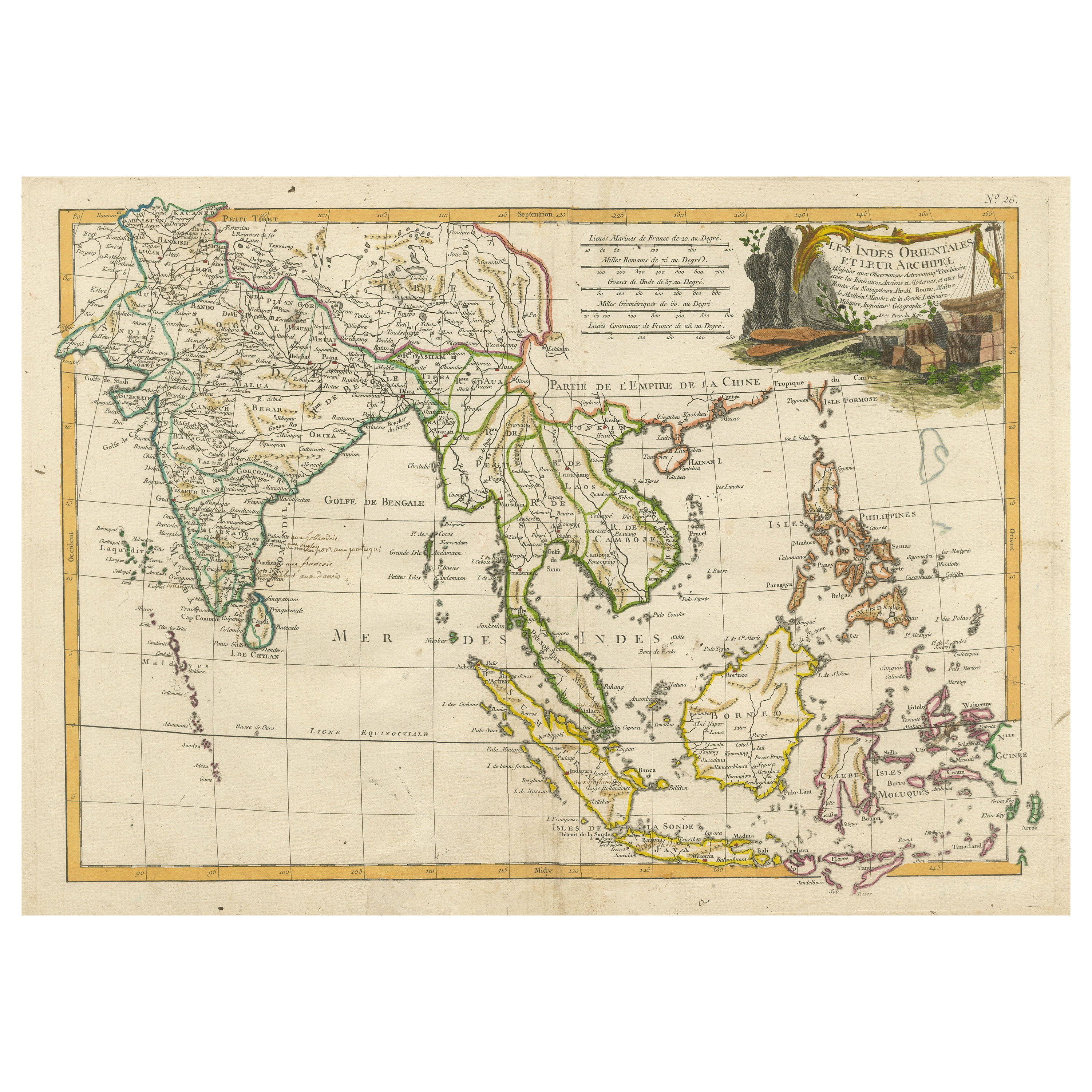
View AllAntique Map of Southeast Asia with Decorative Allegorical Cartouche
Located in Langweer, NL
Antique map titled 'Les Indes Orientales et leur Archipel'. Old map of Southeast Asia, the Straits of Malaca, Philippines, Sumatra, Java, India etc., extending north to Canton and Ma...
Category
Antique Mid-18th Century Maps
Materials
Paper
$902 Sale Price
20% Off
Free Shipping
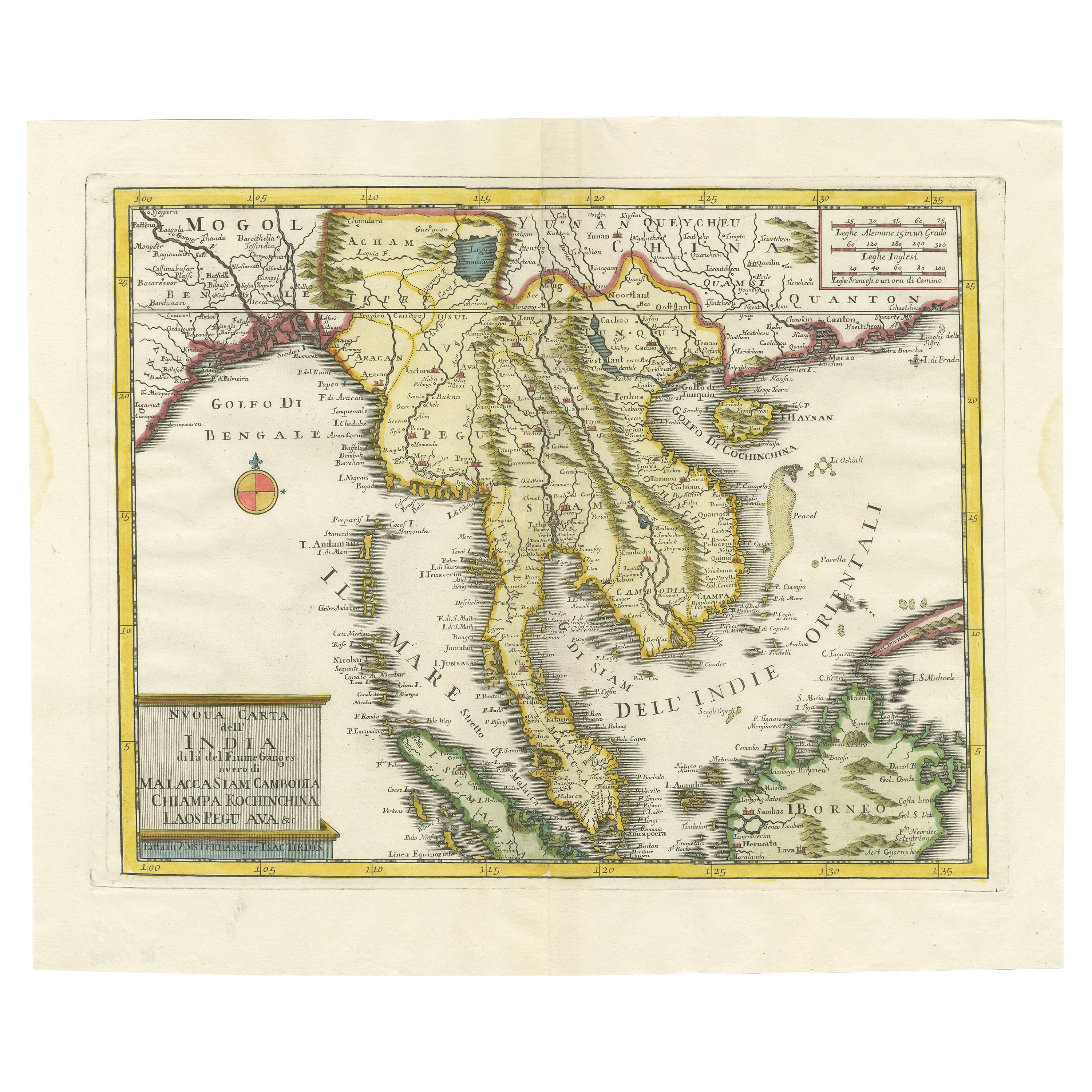
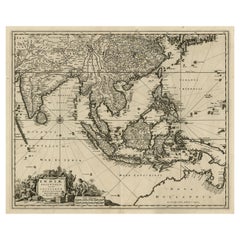
Antique Map of the Region Centered on the Malay Peninsula by Tirion 'c.1760'
Located in Langweer, NL
Antique map titled 'Nuova Carta dell' India (..)'. Decorative map of the region centered on the Malay Peninsula and extending from the Straits of Singapore, Malacca and Borneo in the South to China in the east and the Bay of Bengal...
Category
Antique Mid-18th Century Maps
Materials
Paper
$935 Sale Price
20% Off
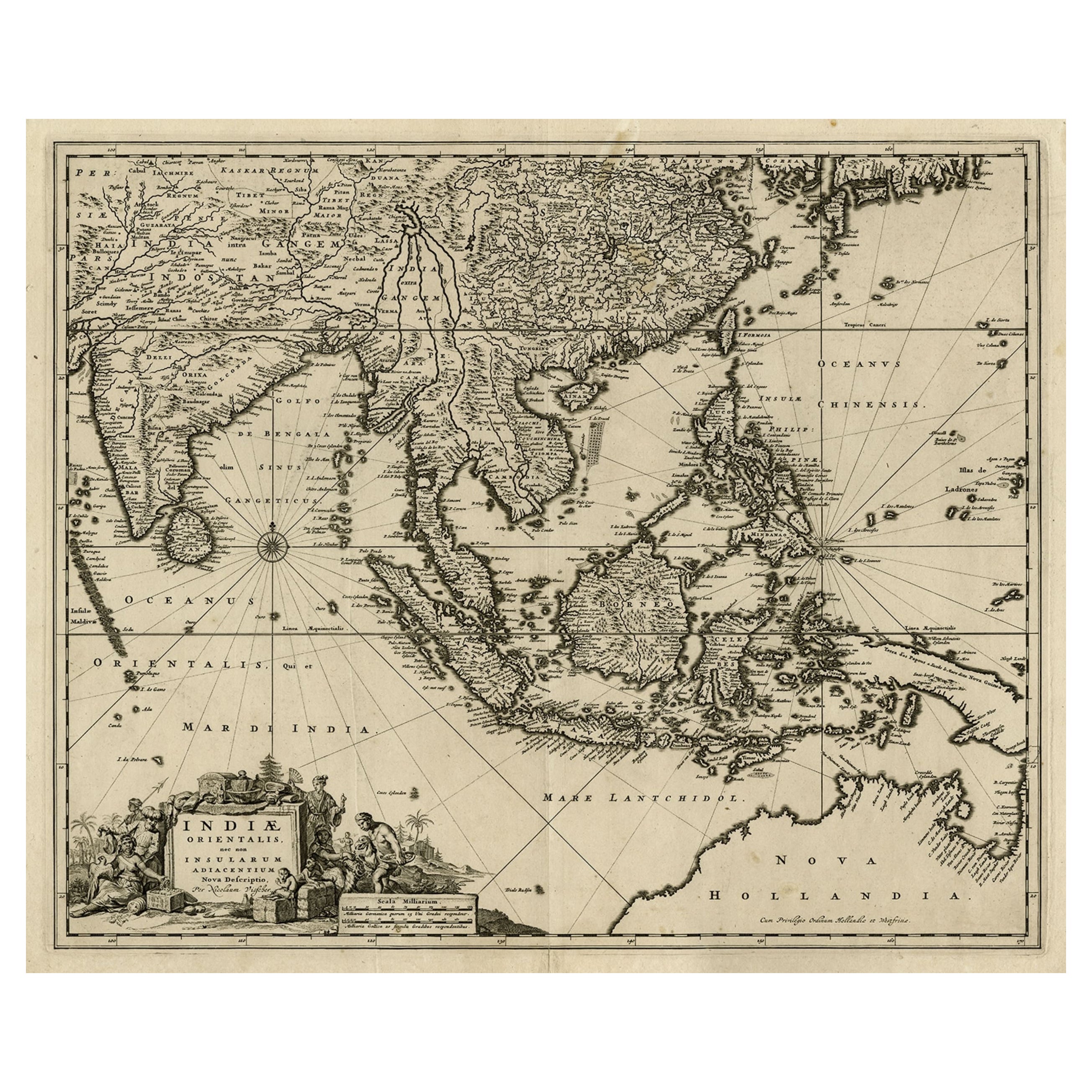
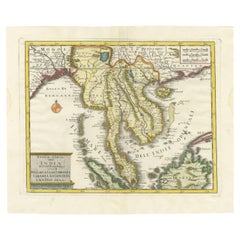
Antique Map of the Strait of Malacca, Malay Peninsula & Dutch Indies, c.1670
Located in Langweer, NL
Antique map titled 'Indiae Orientalis, nec non Insularum Adiacentium Nova Descriptio.'
Map of Southeast Asia. The map centers on the Strait of Malacca and Malay Peninsula. It ext...
Category
Antique 1670s Maps
Materials
Paper
$2,255 Sale Price
20% Off
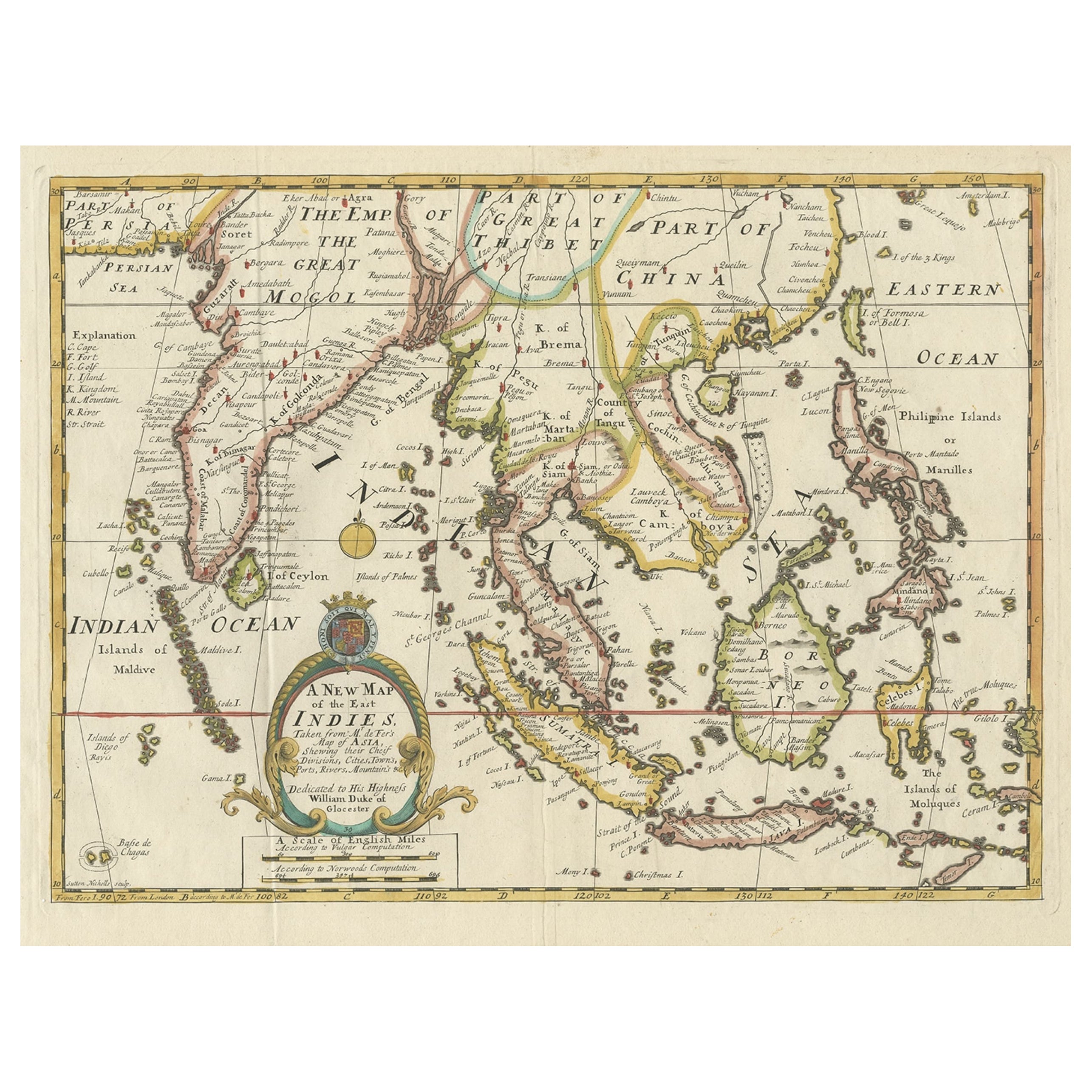
Old Map Covering All of Southeast Asia from Persia to the Timor Island, 1712
Located in Langweer, NL
Description: Antique map titled 'A New Map of the East Indies'. Old map covering all of Southeast Asia from Persia to the Timor Island, inclusive of the modern day nations of India, ...
Category
Antique 1710s Maps
Materials
Paper
$1,439 Sale Price
20% Off
Antique Map of Southeast Asia from Persia to the Timor Island, 1712
Located in Langweer, NL
Antique map titled 'A New Map of the East Indies'.
Old map covering all of Southeast Asia from Persia to the Timor Island, inclusive of the modern day nations of India, Ceylon, T...
Category
Antique 1710s Maps
Materials
Paper

$758 Sale Price
20% Off
Old Antique Map of the East Indies and Southeast Asia, ca.1644
Located in Langweer, NL
Antique map titled 'India quae Orientalis dicitur, et Insulae adiacentes'.
Old map of the East Indies and Southeast Asia showing the area between India in the West and parts of Japan, the Marianas and New Guinea/Australia in the East. This map is dedicated to D. Christophorus Thisius by Henricus...
Category
Antique 1640s Dutch Maps
Materials
Paper

$2,384 Sale Price
25% Off
You May Also Like
Antique French Map of Asia Including China Indoneseia India, 1783
Located in Amsterdam, Noord Holland
Very nice map of Asia. 1783 Dedie au Roy.
Additional information:
Country of Manufacturing: Europe
Period: 18th century Qing (1661 - 1912)
Condition: Overall Condition B (Good Used)...
Category
Antique 18th Century European Maps
Materials
Paper

$648 Sale Price
20% Off
Antique 1803 Italian Map of Asia Including China Indoneseia India
Located in Amsterdam, Noord Holland
Antique 1803 Italian Map of Asia Including China Indoneseia India
Very nice map of Asia. 1803.
Additional information:
Type: Map
Country of Manufacturing: Europe
Period: 19th centu...
Category
Antique 19th Century European Maps
Materials
Paper

$584 Sale Price
20% Off
Map of the East Indies: An Original 18th Century Hand-colored Map by E. Bowen
Located in Alamo, CA
This is an original 18th century hand-colored map entitled "An Accurate Map of the East Indies Exhibiting the Course of the European Trade both on the Continent and Islands" by Emanu...
Category
Mid-18th Century Old Masters Landscape Prints
Materials
Engraving

Original Antique Map of South East Asia by Thomas Clerk, 1817
Located in St Annes, Lancashire
Great map of South East Asia
Copper-plate engraving
Drawn and engraved by Thomas Clerk, Edinburgh.
Published by Mackenzie And Dent, 1817
Unframed.
Category
Antique 1810s English Maps
Materials
Paper

Large Original Vintage Map of S.E Asia, with a Vignette of Singapore
Located in St Annes, Lancashire
Great map of South East Asia
Original color. Good condition
Published by Alexander Gross
Unframed.
Category
Vintage 1920s English Maps
Materials
Paper

Antique Voc Print Holland Malaysia Old Map Melaka History, 1663
Located in Amsterdam, Noord Holland
From my own collection I offer this impressive Antique print of the city of Malakka
A very interesting piece for collectors . It is an museum piece from the Dutch Institute of Orien...
Category
Antique 17th Century European Paintings
Materials
Paper

$293 Sale Price
20% Off
More Ways To Browse
Cape Of Good Hope
Antique Copper Australia
Antique Furniture Pondicherry
Antique Map Of Cornwall
Antique Maps Dublin
Antique Maps Of Malta
Antique Saudi Arabia
Armenia Map
Cambodia Antique Map
Charles Hutchinson
Coronelli Globe
Denoyer Geppert Anatomy
E Fletcher
Framed Africa Maps
Gabon Antique Map
Hudson River Map
Mauritius Antique Map
Nova Hollandia