Items Similar to Antique Map of Bohemia in the Present-Day Chech Repubic, 1730


Want more images or videos?
Request additional images or videos from the seller
1 of 6
Antique Map of Bohemia in the Present-Day Chech Repubic, 1730
$526.76
$658.4520% Off
£388.56
£485.7120% Off
€440
€55020% Off
CA$729.85
CA$912.3120% Off
A$792
A$99020% Off
CHF 419.69
CHF 524.6120% Off
MX$9,713.45
MX$12,141.8120% Off
NOK 5,193.61
NOK 6,492.0120% Off
SEK 4,907.69
SEK 6,134.6120% Off
DKK 3,350.52
DKK 4,188.1420% Off
About the Item
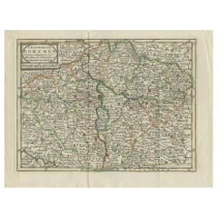
Antique map titled 'Nieuwe Kaart van t Koninkryk Bohemen t Hertogdom Silesien markgraafschap Moravien (Moravia) en Lusatien' (Lusatia). Map of Bohemia (Czech Republic) with the surrounding regions.
Bohemia is the westernmost and largest historical region of the Czech lands in the present-day Czech Republic. Bohemia can also refer to a wider area consisting of the historical Lands of the Bohemian Crown ruled by the Bohemian kings, including Moravia and Czech Silesia, in which case the smaller region is referred to as Bohemia proper as a means of distinction.
Bohemia was a duchy of Great Moravia, later an independent principality, a kingdom in the Holy Roman Empire, and subsequently a part of the Habsburg Monarchy and the Austrian Empire. After World War I and the establishment of an independent Czechoslovak state, the whole of Bohemia became a part of Czechoslovakia, defying claims of the German-speaking inhabitants that regions with German-speaking majority should be included in the Republic of German-Austria. Between 1938 and 1945, these border regions were joined to Nazi Germany as the Sudetenland.
Artists and Engravers: Isaak Tirion, a Dutch publisher in Amsterdam, born 1705. He produced serveral Atlases and Dutch town plans.
Condition: Very good. Contemporary coloring, please study image carefully.
Date: 1730
Overall size: 50.5 x 40 cm.
Image size: 33 x 28.5 cm.
We sell original antique maps to collectors, historians, educators and interior decorators all over the world. Our collection includes a wide range of authentic antique maps from the 16th to the 20th centuries. Buying and collecting antique maps is a tradition that goes back hundreds of years. Antique maps have proved a richly rewarding investment over the past decade, thanks to a growing appreciation of their unique historical appeal. Today the decorative qualities of antique maps are widely recognized by interior designers who appreciate their beauty and design flexibility. Depending on the individual map, presentation, and context, a rare or antique map can be modern, traditional, abstract, figurative, serious or whimsical. We offer a wide range of authentic antique maps for any budget.
- Dimensions:Height: 15.75 in (40 cm)Width: 19.89 in (50.5 cm)Depth: 0 in (0.01 mm)
- Materials and Techniques:
- Period:
- Date of Manufacture:1730
- Condition:
- Seller Location:Langweer, NL
- Reference Number:Seller: BG-068361stDibs: LU3054326080542
About the Seller
5.0
Recognized Seller
These prestigious sellers are industry leaders and represent the highest echelon for item quality and design.
Platinum Seller
Premium sellers with a 4.7+ rating and 24-hour response times
Established in 2009
1stDibs seller since 2017
2,622 sales on 1stDibs
Typical response time: <1 hour
- ShippingRetrieving quote...Shipping from: Langweer, Netherlands
- Return Policy
Authenticity Guarantee
In the unlikely event there’s an issue with an item’s authenticity, contact us within 1 year for a full refund. DetailsMoney-Back Guarantee
If your item is not as described, is damaged in transit, or does not arrive, contact us within 7 days for a full refund. Details24-Hour Cancellation
You have a 24-hour grace period in which to reconsider your purchase, with no questions asked.Vetted Professional Sellers
Our world-class sellers must adhere to strict standards for service and quality, maintaining the integrity of our listings.Price-Match Guarantee
If you find that a seller listed the same item for a lower price elsewhere, we’ll match it.Trusted Global Delivery
Our best-in-class carrier network provides specialized shipping options worldwide, including custom delivery.More From This Seller
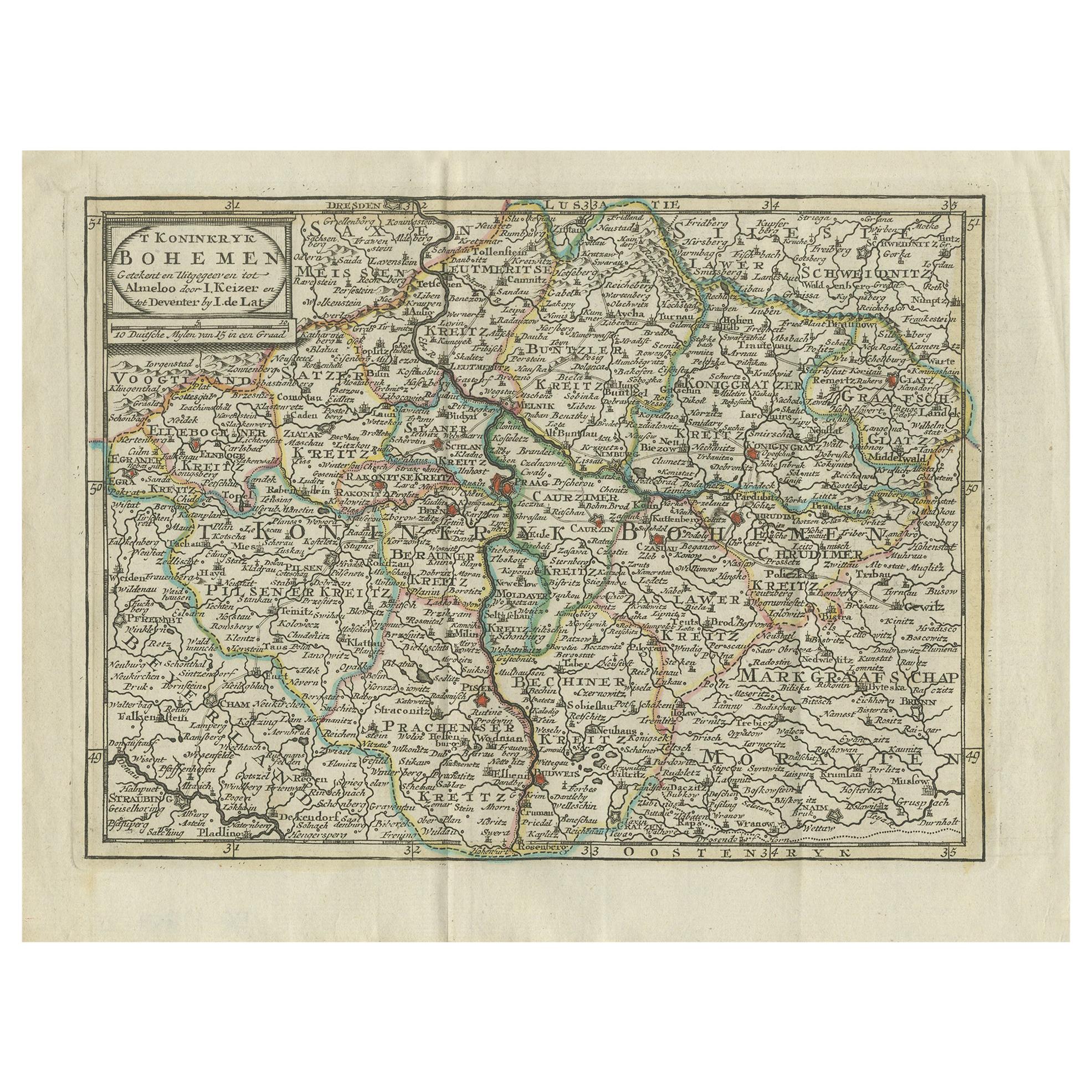
View AllAntique Map of the Kingdom of Bohemia by Keizer & de Lat, 1788
Located in Langweer, NL
Antique map titled 't Koninkryk Bohemen (..)'. Uncommon original antique map of the Kingdom of Bohemia. This map originates from 'Nieuwe Natuur- Geschied- en Handelkundige Zak- en Re...
Category
Antique Late 18th Century Maps
Materials
Paper
$335 Sale Price
20% Off
Old Map of the Western Part of Central Europe, c.1680
Located in Langweer, NL
Antique map titled 'Carta nova accurate del Passagio et strada dalli Paesi Bassi'. Old map of the western portion of Central Europe. Oriented to the Northeast.
Artists and Engrav...
Category
Antique 17th Century Maps
Materials
Paper

$359 Sale Price
20% Off
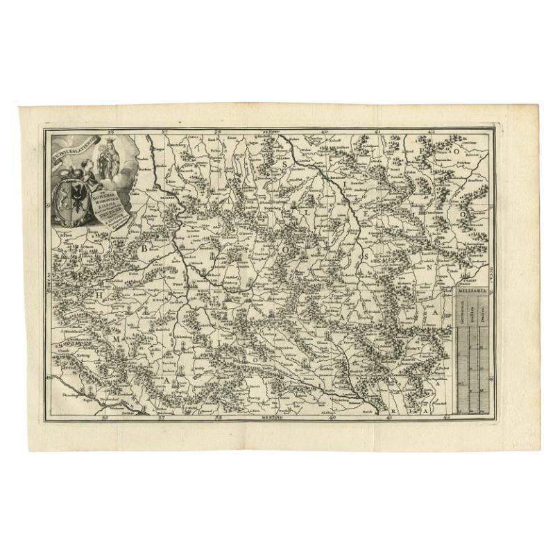
Antique Uncommon Map of Bohemia, Moravia and Silesia, 1699
Located in Langweer, NL
Antique map titled 'B. V. Boleslaviensis in Bohemia, Moravia et Silesia (..).' Detailed uncommon map of the Bohemia, Moravia and Silesia. Source unknown, to be determined.
Artists...
Category
Antique 17th Century Maps
Materials
Paper
$459 Sale Price
20% Off
Antique Map of Lower Saxony in Germany, c.1740
Located in Langweer, NL
Antique map titled 'Nieuwe Kaart van de Neder Saxise Kreits (..).' Attractive detailed map showing Lower Saxony, Germany, including Mekelenburg, Lauwenburg, Holstein, Bremen, Verden ...
Category
Antique 18th Century Maps
Materials
Paper

$526 Sale Price
20% Off
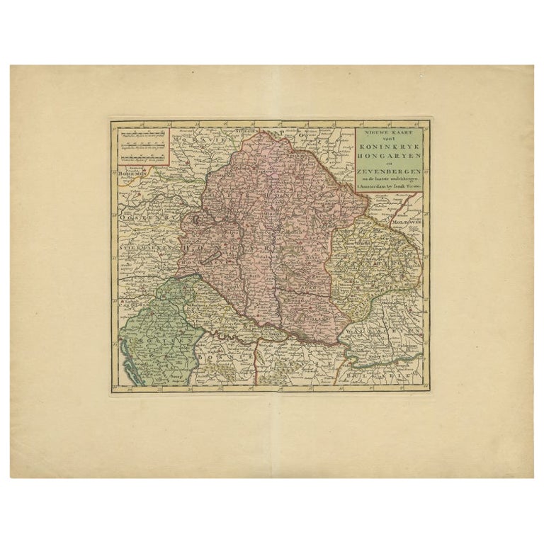
Antique Map of Hungary Incl Surroundings like Croatia, Bosnia, Servia, 1730
Located in Langweer, NL
Antique map titled 'Nieuwe Kaart van t Koninkryk Hongaryen en Zevenbergen na de laatste ontdekkingen'.
This map depicts Hungary including surroundings like Croatia, Bosnia, Servia,...
Category
Antique 18th Century Maps
Materials
Paper

$526 Sale Price
20% Off
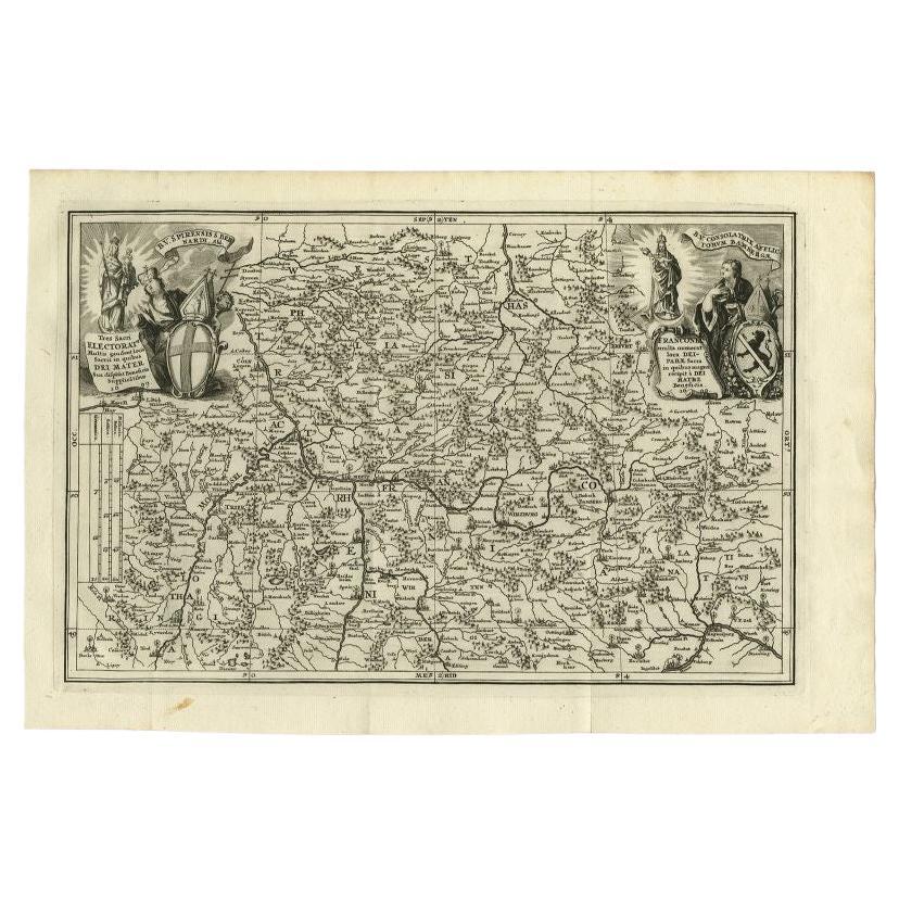
Antique Map of the Franconia Region by Scherer, 1699
Located in Langweer, NL
Antique map titled 'Franconia multa numerat loca deiparae sacra in quibus magna recipit à dei matre beneficia.' Detailed uncommon map of the Franconia region in Germany. Source unkno...
Category
Antique 17th Century Maps
Materials
Paper
$215 Sale Price
20% Off
You May Also Like
1633 Map Entitled "Beauvaisis Comitatus Belova Cium, Ric.0002
Located in Norton, MA
1633 map entitled
"Beauvaisis Comitatus Belova Cium,"
Hand Colored
Ric.0002
Description: Cartographer : - Hondius, Henricus 1587-1638
Artists and Engravers:Jodocus Hondius, one of the most notable engravers of his time. He is known for his work in association with many of the cartographers and publishers prominent at the end of the sixteenth and the beginning of the seventeenth century. A native of Flanders, he grew up in Ghent, apprenticed as an instrument and globe maker and map engraver. In 1584, to escape the religious troubles sweeping the Low Countries at that time, he fled to London where he spent some years before finally settling in Amsterdam about 1593. In the London period he came into contact with the leading scientists and geographers of the day and engraved maps in The Mariner\\\\\\\\\\\\\\\'s Mirrour, the English edition of Waghenaer\\\\\\\\\\\\\\\'s Sea Atlas, as well as others with Pieter van den Keere, his brother-in-law. No doubt his temporary exile in London stood him in good stead, earning him an international reputation, for it could have been no accident that Speed chose Hondius to engrave the plates for the maps in The Theatre of the Empire of Great Britaine in the years between 1605 and 1610. In 1604 Hondius bought the plates of Mercator\\\\\\\\\\\\\\\'s Atlas which, in spite of its excellence, had not competed successfully with the continuing demand for the Ortelius Theatrum Orbis Terrarum. To meet this competition Hondius added about 40 maps to Mercator\\\\\\\\\\\\\\\'s original number and from 1606 published enlarged editions in many languages, still under Mercator\\\\\\\\\\\\\\\'s name but with his own name as publisher. These atlases have become known as the Mercator/Hondius series. The following year the maps were reengraved in miniature form and issued as a pocket Atlas Minor. After the death of Jodocus Hondius the Elder in 1612, work on the two atlases, folio and miniature, was carried on by his widow and sons, Jodocus II and Henricus, and eventually in conjunction with Jan Jansson in Amsterdam.
In all, from 1606 onwards, nearly 50 editions with increasing numbers of maps with texts in the main European languages were printed. Summaries of these issues are given under the entry for Gerard Mercator. Jodocus Hondius the Elder * 1588 Maps in The Mariner\\\\\\\\\\\\\\\'s Mirrour (Waghenaer/Ashley) * 1590 World Map...
Category
Antique 17th Century Dutch Maps
Materials
Paper

17th Century Nicolas Visscher Map of Southeastern Europe
Located in Hamilton, Ontario
A beautiful, highly detailed map of southeastern Europe by Nicolas Visscher. Includes regions of Northern Italy (showing the cities Bologna, Padua, and Venice), Bohemia, Austria (sho...
Category
Antique 17th Century Dutch Maps
Materials
Paper

$1,350 Sale Price
38% Off
West Germany: Original Hand Colored 17th Century Map by Johannes Janssonius
By Johannes Janssonius
Located in Alamo, CA
An original hand colored copperplate engraved map entitled in Latin "Archiepiscopatus Maghdeburgensis et Anhaltinus Ducatus cum terris adjacentibus", published in Amsterdam in 1640 i...
Category
Mid-17th Century Old Masters More Prints
Materials
Engraving

1752 Vaugoundy Map of Flanders : Belgium, France, and the Netherlands, Ric.a002
Located in Norton, MA
Large Vaugoundy Map of Flanders:
Belgium, France, and the Netherlands
Colored -1752
Ric.a002
Description: This is a 1752 Didier Robert de Vaugondy map of Flanders. The map de...
Category
Antique 17th Century Unknown Maps
Materials
Paper

1853 Map of "Russia in Europe Including Poland" Ric.r016
Located in Norton, MA
Description
Russia in Europe incl. Poland by J Wyld c.1853
Hand coloured steel engraving
Dimension: Paper: 25 cm W x 33 cm H ; Sight: 22 cm W x 28 cm H
Condition: Good ...
Category
Antique 19th Century Unknown Maps
Materials
Paper

1620 Map of Artois Entitled "Artesia Comitatvs Artois, " by Bleau, Ric.a012
Located in Norton, MA
1640 map of Artois entitled
"Artesia Comitatvs Artois,"
by Bleau
Colored
A-012.
Detailed map of the northern province of Artois, France on the border with Belgium. Feature...
Category
Antique 17th Century Dutch Maps
Materials
Paper

More Ways To Browse
Austrian Empire
Birds Eye View Map
North Africa Map
West Africa Map
Antique Compass Map
Antique Maps California
Biblical Maps
Hungary Map
Maps Of Mediterranean
Treasure Map
Antique Navigational Tools
Mississippi Furniture
Caribbean Antiques
Antique Maps West Indies
Antique Mozambique
Malaysian Antique Furniture
Relief Map
Sur Tout