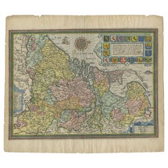
Items Similar to Antique Map of East Frisia by Ortelius, c.1595

Want more images or videos?
Request additional images or videos from the seller
1 of 5
Antique Map of East Frisia by Ortelius, c.1595
$814.08
$1,017.6020% Off
£600.51
£750.6420% Off
€680
€85020% Off
CA$1,127.95
CA$1,409.9320% Off
A$1,223.99
A$1,529.9920% Off
CHF 648.61
CHF 810.7620% Off
MX$15,011.69
MX$18,764.6220% Off
NOK 8,026.49
NOK 10,033.1120% Off
SEK 7,584.61
SEK 9,480.7620% Off
DKK 5,178.07
DKK 6,472.5920% Off
About the Item
Antique print, titled: 'Frisia Orientalis.' Map of East Frisia originating from 'Theatrum Orbis Terrarum'. It is based on the manuscript map by Jon Bloemmaerts or Johannes Florianus and depicts the important shipping center of Emden and the Watten Islands. An inset shows the region inundated by the great flood on Christmas Day, 1277, surrounded by an elaborate strapwork cartouche. The map is finely engraved with a stippled sea and a distance scale surmounted by male and female figures displaying the costumes of the region. Latin text on verso.
Artists and Engravers: Abraham Ortelius was born 1528 in Antwerp. He studied mathematics, Greek and Latin and travelled a lot across Europe. He established a business in dealing with books and drawing maps. His first remarkable map was a 8 sheet world map in the year 1564, but only three copies have survived. In 1570 he issued the ""Theatrum Orbis Terrarum"", the first modern ""Atlas"" with uniformly sized maps in a systematic collection. The term ""Atlas"" was not used until Mercator introduced it 20 years later. Most of the maps in Theatrum have been engraved by Frans Hogenberg. At the time of publication, the atlas was the most expensive book ever printed. Nevertheless it was a big success and around 7000 copies have been printed until 1612 in many editions and six different languages. Beside the Theatrum, Ortelius compiled a series of historical maps and published it in the ""Parergon Theatri"" which was bound with the Theatrum from 1579 onwards or published separately.
Condition: Good. Age-related toning. Please study image carefully.
Date: c.1595
Overall size: 55.8 x 46 cm.
Image size: 0.001 x 49.6 x 37.4 cm.
We sell original antique maps to collectors, historians, educators and interior decorators all over the world. Our collection includes a wide range of authentic antique maps from the 16th to the 20th centuries. Buying and collecting antique maps is a tradition that goes back hundreds of years. Antique maps have proved a richly rewarding investment over the past decade, thanks to a growing appreciation of their unique historical appeal. Today the decorative qualities of antique maps are widely recognized by interior designers who appreciate their beauty and design flexibility. Depending on the individual map, presentation, and context, a rare or antique map can be modern, traditional, abstract, figurative, serious or whimsical. We offer a wide range of authentic antique maps for any budget.
- Dimensions:Height: 18.12 in (46 cm)Width: 21.97 in (55.8 cm)Depth: 0 in (0.01 mm)
- Materials and Techniques:
- Period:
- Date of Manufacture:c.1595
- Condition:
- Seller Location:Langweer, NL
- Reference Number:Seller: BG-067791stDibs: LU3054326172112
About the Seller
5.0
Recognized Seller
These prestigious sellers are industry leaders and represent the highest echelon for item quality and design.
Platinum Seller
Premium sellers with a 4.7+ rating and 24-hour response times
Established in 2009
1stDibs seller since 2017
2,622 sales on 1stDibs
Typical response time: <1 hour
- ShippingRetrieving quote...Shipping from: Langweer, Netherlands
- Return Policy
Authenticity Guarantee
In the unlikely event there’s an issue with an item’s authenticity, contact us within 1 year for a full refund. DetailsMoney-Back Guarantee
If your item is not as described, is damaged in transit, or does not arrive, contact us within 7 days for a full refund. Details24-Hour Cancellation
You have a 24-hour grace period in which to reconsider your purchase, with no questions asked.Vetted Professional Sellers
Our world-class sellers must adhere to strict standards for service and quality, maintaining the integrity of our listings.Price-Match Guarantee
If you find that a seller listed the same item for a lower price elsewhere, we’ll match it.Trusted Global Delivery
Our best-in-class carrier network provides specialized shipping options worldwide, including custom delivery.More From This Seller
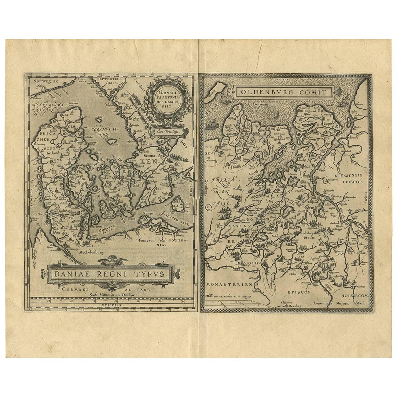
View AllDaniae Regni & Oldenburg – Antique Maps of Denmark and Saxony by Ortelius, 1598
Located in Langweer, NL
Daniae Regni & Oldenburg – Antique Maps of Denmark and Saxony by Ortelius, 1584
This elegant antique map sheet features two detailed regional maps side by side: Daniae Regni Typus (...
Category
Antique 16th Century European Maps
Materials
Paper
$861 Sale Price
20% Off
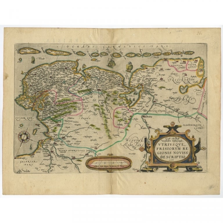
Antique Map of Friesland with Elaborate Cartouche by Mapmaker Ortelius, c.1570
Located in Langweer, NL
Antique map titled 'Oost end West Vrieslandts beschrijvinghe. Utriusque Frisiorum Regionis Noviss: Descriptio. 1568.' Detailed map of Friesland, the Netherlands. Includes a larger co...
Category
Antique 16th Century Maps
Materials
Paper

$909 Sale Price
20% Off
Original Antique Map of Friesland by Guicciardini, 1612
Located in Langweer, NL
Antique map titled 'Frisiae Occidentalis Typus'. Original antique map of the province of Friesland, the Netherlands. This map originates from 'Beschryvinghe van alle de Neder-Landen'...
Category
Antique 17th Century Maps
Materials
Paper
$526 Sale Price
20% Off
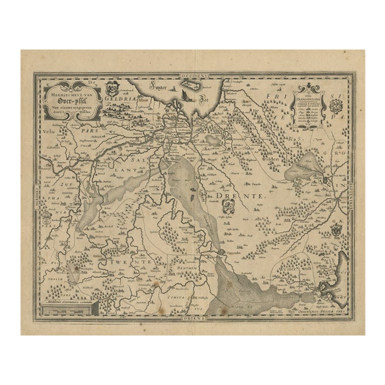
Antique Map of Overijssel by Visscher, 1632
Located in Langweer, NL
Antique map titled 'De Heerlyckheyt van Over-IJssel'. Old map of the province of Overijssel, the Netherlands. Also depicted are various coats of arms. Artists and Engravers: Engraved...
Category
Antique 17th Century Maps
Materials
Paper

$491 Sale Price
20% Off
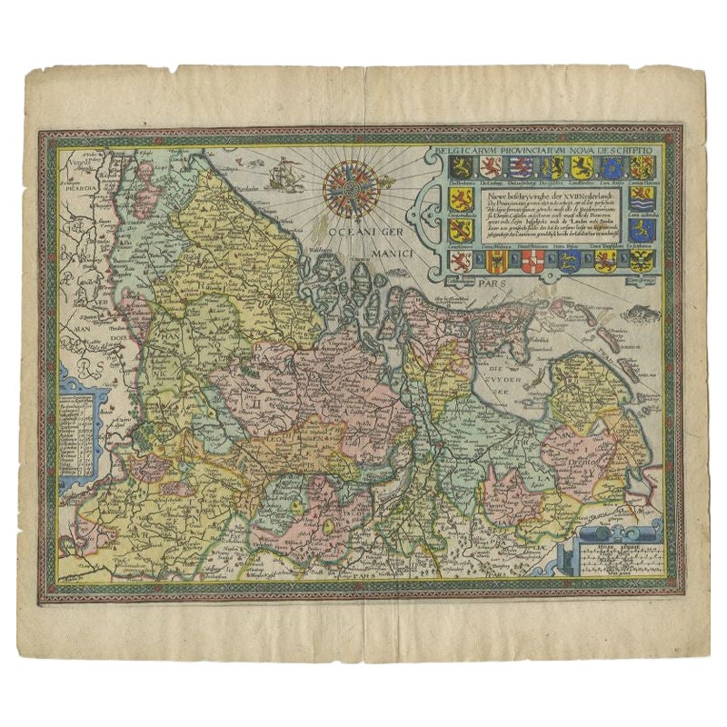
Antique Map of the Netherlands by Guicciardini, 1612
Located in Langweer, NL
Antique map titled 'Belgicarum Provinciarum Nova Descriptio'. Beautiful old map of the Netherlands. With decorative cartouche including the coat...
Category
Antique 17th Century Maps
Materials
Paper
$430 Sale Price
20% Off
Antique Map by Janssonius of the Dutch Province of Overijsel, ca.1650
Located in Langweer, NL
Very good, given the age. Center fold as issued with wide margins. Sharp print with beautiful old-fashioned colouring, carbon copy on verso. Paper in the margins somewhat browned.
Category
Antique 1650s Maps
Materials
Paper

$421 Sale Price
20% Off
You May Also Like
1646 Jansson Map Entitled "Procinvia Connactiae, " Ric.a006
Located in Norton, MA
1646 Jansson map entitled
"Procinvia connactiae,"
Ric.a006
Description: The PROVINCE of CONNAVGT 490 x 380From vol 4 of Jansson's Atlas Novus 1646, published in Amsterdam with...
Category
Antique 17th Century Unknown Maps
Materials
Paper

1636 Jansson Map of Ireland Entitled "Comitatus Lageniae, " Ric.a007
Located in Norton, MA
1646 Jansson map entitled
"Procinvia connactiae,"
Ric.a006
Description: The PROVINCE of CONNAVGT 490 x 380From vol 4 of Jansson's Atlas Novus 1646, published in Amsterdam with...
Category
Antique 17th Century Unknown Maps
Materials
Paper

1590 Ortelius Map of Calais and Vermandois, France and Vicinity Ric.a014
Located in Norton, MA
1590 Ortelius map of
Calais and Vermandois, France and Vicinity
Ric.a014
Two rare regional Abraham Ortelius maps on a single folio sheet. Left map, entitled Caletensium, depic...
Category
Antique 16th Century Dutch Maps
Materials
Paper

1592 Abraham Ortelius Map "Lorraine: Lotharingiae Nova Descripti, Ric.A005
Located in Norton, MA
1592 Abraham Ortelius map entitled
"Lorraine: Lotharingiae Nova Descripti
Ric.a005
Description: Ortelius is best known for producing the atlas from which this map comes from, "...
Category
Antique 16th Century Dutch Maps
Materials
Paper

Original Antique Map of Switzerland, Engraved By Barlow, Dated 1807
Located in St Annes, Lancashire
Great map of Switzerland
Copper-plate engraving by Barlow
Published by Brightly & Kinnersly, Bungay, Suffolk.
Dated 1807
Unframed.
Category
Antique Early 1800s English Maps
Materials
Paper

1627 Hendrik Hondius Map Entitled "Vltoniae Orientalis Pars, " Ric.a009
Located in Norton, MA
1627 Hendrik Hondius map entitled
"Vltoniae orientalis pars,"
Ric.a009
Title:
Vltoniae orientalis : pars
Title (alt.) :
Ultoniae orientalis pars
Creator:
Mercator, Gerh...
Category
Antique 17th Century Dutch Maps
Materials
Paper
