Items Similar to Antique Map of French Polynesia by Cook Showing His Route, 1803


Want more images or videos?
Request additional images or videos from the seller
1 of 5
Antique Map of French Polynesia by Cook Showing His Route, 1803
$451.68
$564.6020% Off
£336.36
£420.4520% Off
€380
€47520% Off
CA$623.60
CA$779.5020% Off
A$691.36
A$864.1920% Off
CHF 363.33
CHF 454.1720% Off
MX$8,461.06
MX$10,576.3320% Off
NOK 4,537.68
NOK 5,672.1020% Off
SEK 4,259.07
SEK 5,323.8320% Off
DKK 2,893.19
DKK 3,616.4920% Off
About the Item
Antique map Tahiti titled 'Kaart van de Eilanden in den omtrek van Otahiti (..)'. Antique map of French Polynesia with the tracks around the island of Tahiti by Captain Byron, Wallis, Carteret and Cook in 1765, 1767 and 1769. Originates from 'Reizen Rondom de Waereld door James Cook (..)'. Artists and Engravers: Translated by J.D. Pasteur. Published by Honkoop, Allart en Van Cleef.
Artist: Translated by J.D. Pasteur. Published by Honkoop, Allart en Van Cleef.
Condition: Good, general age-related toning and some foxing. Please study image carefully.
Date: 1803
Overall size: 52.5 x 35.5 cm.
Image size: 49.5 x 24 cm.
We sell original antique maps to collectors, historians, educators and interior decorators all over the world. Our collection includes a wide range of authentic antique maps from the 16th to the 20th centuries. Buying and collecting antique maps is a tradition that goes back hundreds of years. Antique maps have proved a richly rewarding investment over the past decade, thanks to a growing appreciation of their unique historical appeal. Today the decorative qualities of antique maps are widely recognized by interior designers who appreciate their beauty and design flexibility. Depending on the individual map, presentation, and context, a rare or antique map can be modern, traditional, abstract, figurative, serious or whimsical. We offer a wide range of authentic antique maps for any budget.
- Dimensions:Height: 13.98 in (35.5 cm)Width: 20.67 in (52.5 cm)Depth: 0 in (0.01 mm)
- Materials and Techniques:
- Period:
- Date of Manufacture:1803
- Condition:
- Seller Location:Langweer, NL
- Reference Number:Seller: BG-11487-71stDibs: LU3054326281812
About the Seller
5.0
Recognized Seller
These prestigious sellers are industry leaders and represent the highest echelon for item quality and design.
Platinum Seller
Premium sellers with a 4.7+ rating and 24-hour response times
Established in 2009
1stDibs seller since 2017
2,609 sales on 1stDibs
Typical response time: <1 hour
- ShippingRetrieving quote...Shipping from: Langweer, Netherlands
- Return Policy
Authenticity Guarantee
In the unlikely event there’s an issue with an item’s authenticity, contact us within 1 year for a full refund. DetailsMoney-Back Guarantee
If your item is not as described, is damaged in transit, or does not arrive, contact us within 7 days for a full refund. Details24-Hour Cancellation
You have a 24-hour grace period in which to reconsider your purchase, with no questions asked.Vetted Professional Sellers
Our world-class sellers must adhere to strict standards for service and quality, maintaining the integrity of our listings.Price-Match Guarantee
If you find that a seller listed the same item for a lower price elsewhere, we’ll match it.Trusted Global Delivery
Our best-in-class carrier network provides specialized shipping options worldwide, including custom delivery.More From This Seller
View AllAntique Map of Eastern Polynesia, 1849
Located in Langweer, NL
Antique map titled 'Ost-Polynesien'. Interesting variant issue, with large detailed insets top right of Hawaii volcanos near Kilauea. Insets lower right of Honolulu harbour, island o...
Category
Antique Mid-19th Century Maps
Materials
Paper

$166 Sale Price
30% Off
Antique Map of Polynesia and Australasia by Neele, 1825
Located in Langweer, NL
Antique map titled 'Polynesia and Australasia'. It shows Australia (New Holland), part of Asia, New Zealand and many islands. This map originates from 'Encyclopedia Londinensis'.
Category
Antique Early 19th Century Maps
Materials
Paper

$114 Sale Price
20% Off
Antique Map of New Guinea and New Britain by P. Carteret, circa 1773
Located in Langweer, NL
Antique Map: A Chart of Captain Carteret's Discoveries at New Britain (1769)
This rare and historically significant 18th-century map, titled *A Chart of Captn Carteret's Discoveries at New Britain,* offers a fascinating glimpse into early European explorations of the Pacific. Published in 1769, the map meticulously charts Captain Philip Carteret's 1767 voyage through New Guinea and the islands of New Britain and New Ireland, showcasing his contributions to the understanding of the Bismarck Archipelago. Adding to its significance, the map traces the paths of earlier explorer William Dampier...
Category
Antique Late 18th Century Maps
Materials
Paper

$523 Sale Price
20% Off
Antique Map of the Friendly Islands by Cook, 1803
Located in Langweer, NL
Antique map Friendly Islands titled 'Kaart van de Vrienden-Eilanden'. Antique map of the Friendly Islands depicting Rotterdam or Anamocka, Middelburg or Eaoowe and Amsterdam or Tonga...
Category
Antique 19th Century Maps
Materials
Paper

$204 Sale Price
20% Off
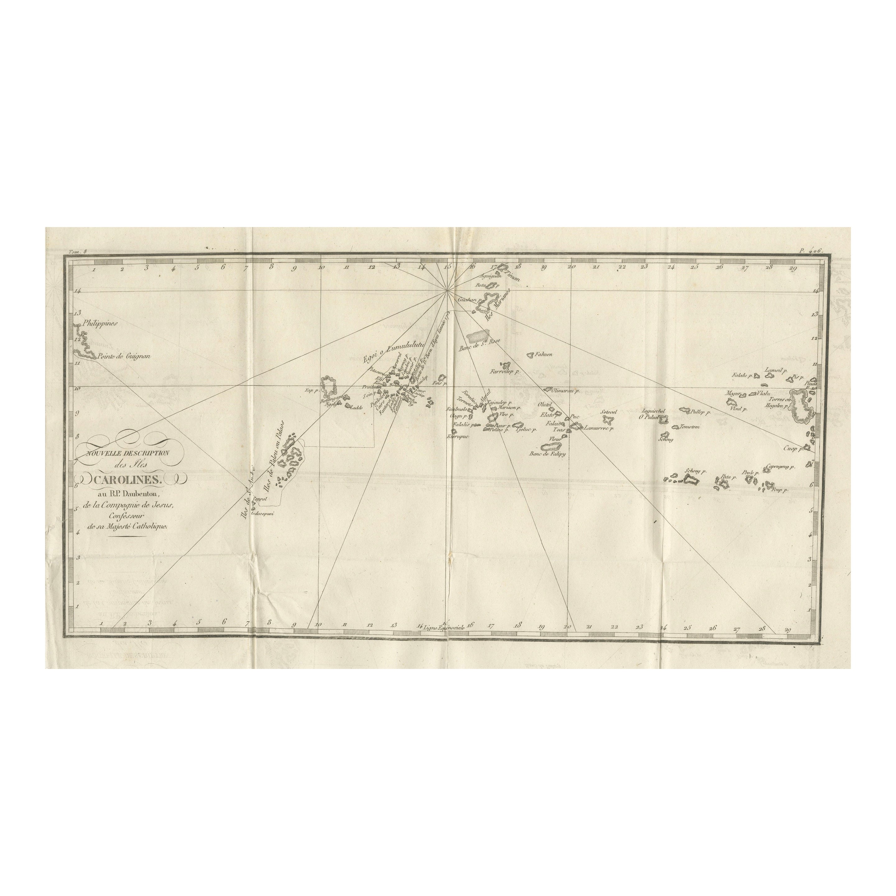
Antique Map of the Caroline Islands – Early Exploration of the Pacific, c.1760
Located in Langweer, NL
Map of the Caroline Islands – “Nouvelle Description des Isles Carolines”, c.1760
This 18th-century copperplate map, titled Nouvelle Description des Isles Carolines, charts the Carol...
Category
Antique Mid-18th Century French Maps
Materials
Paper
Antique Map of Western Polynesia, 1849
Located in Langweer, NL
Antique map titled 'Ost-Polynesien'. Detailed map of the western Pacific extending from the Celebes to Samoa and including part of Australia. Insets of...
Category
Antique Mid-19th Century Maps
Materials
Paper

$166 Sale Price
30% Off
You May Also Like
Captain Cook's Exploration of Tahiti: 18th C. Hand-colored Map by Bellin
By Jacques-Nicolas Bellin
Located in Alamo, CA
This beautiful 18th century hand-colored copper plate engraved map is entitled "Carte de l'Isle de Taiti, par le Lieutenant J. Cook" was created by Jacques Nicolas Bellin and publish...
Category
Late 18th Century Landscape Prints
Materials
Engraving

Original Antique Map of US Possessions In The Pacific Ocean, C.1900
Located in St Annes, Lancashire
Fabulous map of US possessions in the Pacific Ocean
Original color.
Engraved and printed by the George F. Cram Company, Indianapolis.
Published, C.1900.
Unframed.
Free shipping.
Category
Antique 1890s American Maps
Materials
Paper

Ancient Map of Oceania - Original Etching - 19th century
Located in Roma, IT
This Map of Oceania is an etching realized in the 19th century.
The state of preservation of the artwork is good. At the top of the paper, the inscription “Longitudine del Meridiano...
Category
19th Century More Prints
Materials
Etching

Original Antique Map of South America. C.1780
Located in St Annes, Lancashire
Great map of South America
Copper-plate engraving
Published C.1780
Two small worm holes to left side of map
Unframed.
Category
Antique Early 1800s English Georgian Maps
Materials
Paper

Large Original Antique Map of The Pacific Ocean, Fullarton, C.1870
Located in St Annes, Lancashire
Great map of The Pacific Ocean
From the celebrated Royal Illustrated Atlas
Lithograph by Swanston. Original color.
Published by Fullarton,...
Category
Antique 1870s Scottish Maps
Materials
Paper

Large Original Antique Map of The Leeward Islands. 1894
Located in St Annes, Lancashire
Superb Antique map of The Leeward Islands
Published Edward Stanford, Charing Cross, London 1894
Original colour
Good condition
Unframed.
Free shipping
Category
Antique 1890s English Maps
Materials
Paper

More Ways To Browse
Cook Islands
Map Of Singapore
Migeon Migeon
Scottish Coat Of Arms
Antique Maps Of Canada
Antique Railroad Maps
Relief Map
Antique Map Of Venice
Antique Map Of Georgia
Antique Nautical Charts
Hand Painted Antique Map
Antique Maps New Zealand
Antique Maps Persia
Map Railroad
Mariner Furniture
Vintage Glass Map
Antique Furniture Cyprus
Antique Linen Map