Items Similar to Antique Map of Gelderland and Overijssel by Guicciardini, 1613


Want more images or videos?
Request additional images or videos from the seller
1 of 6
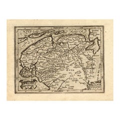
Antique Map of Gelderland and Overijssel by Guicciardini, 1613
$267.82
$334.7720% Off
£198.27
£247.8320% Off
€224
€28020% Off
CA$370.59
CA$463.2420% Off
A$408.57
A$510.7120% Off
CHF 213.75
CHF 267.1920% Off
MX$5,012.40
MX$6,265.5020% Off
NOK 2,690.70
NOK 3,363.3720% Off
SEK 2,516.23
SEK 3,145.2920% Off
DKK 1,706.29
DKK 2,132.8720% Off
About the Item
Antique map titled 'Geldria et Transisulania.' (Map of the provinces of Gelderland and Overijssel, the Netherlands.) This original old antique print / plate originates from the scarse French edition of 'Description de touts les Pays-Bas ...', by L. Guicciardini, published by Jan Janszn., Arnhem and Petrus van der Keere, Amsterdam in 1613.
Artists and Engravers: The author of this work: Lodovico Guicciardini (1521-1589): Italian merchant from aristocratic descent. He was born in Florence, a son of Jacopo Guicciardini. His uncle was the famous author Francesco Guicciardini (1483-1540) who wrote 'La historia di Italia'. The Guicciardini family established a presence in Antwerp and in 1541 Lodovico arrived to work with his uncle. At the same time they functioned as informents for the Medici's back home. He stayed until his death. At one point he was accused with his brother Giovan Battista of killing Gaspare Ducci, who they held resposible for their bancruptcy in 1543. Lodovico apparently started writing in 1552 and in 1556 he published his first work 'Comentarii della......', about European history. In 1567 he got the 'Descrittione....' published. He wrote a few more works. In 1569 he landed in jail because he critisized Alva's policies. In 1582 he landed in jail again because he apparently knew Jean Jaureguy, who tried to kill William of Orange, but he was released soon. Although he had been prosperous at times he ended a poor man. Plates engraved by the very skilled Pieter van den Keere or Petrus Kaerius (1571-1646), a Flemish engraver, publisher and globe maker.
Condition: Good, general age related toning and occasional light staining from handling. Please study image carefully.
Date: 1613
Overall size: 23.5 x 17.5 cm.
Image size: 18.5 x 13 cm.
We sell original antique maps to collectors, historians, educators and interior decorators all over the world. Our collection includes a wide range of authentic antique maps from the 16th to the 20th centuries. Buying and collecting antique maps is a tradition that goes back hundreds of years. Antique maps have proved a richly rewarding investment over the past decade, thanks to a growing appreciation of their unique historical appeal. Today the decorative qualities of antique maps are widely recognized by interior designers who appreciate their beauty and design flexibility. Depending on the individual map, presentation, and context, a rare or antique map can be modern, traditional, abstract, figurative, serious or whimsical.
- Dimensions:Height: 6.89 in (17.5 cm)Width: 9.26 in (23.5 cm)Depth: 0 in (0.01 mm)
- Materials and Techniques:
- Period:
- Date of Manufacture:1613
- Condition:Condition: Good, general age related toning and occasional light staining from handling. Please study image carefully.
- Seller Location:Langweer, NL
- Reference Number:Seller: PCT-157491stDibs: LU3054329642842
About the Seller
5.0
Recognized Seller
These prestigious sellers are industry leaders and represent the highest echelon for item quality and design.
Platinum Seller
Premium sellers with a 4.7+ rating and 24-hour response times
Established in 2009
1stDibs seller since 2017
2,613 sales on 1stDibs
Typical response time: <1 hour
- ShippingRetrieving quote...Shipping from: Langweer, Netherlands
- Return Policy
Authenticity Guarantee
In the unlikely event there’s an issue with an item’s authenticity, contact us within 1 year for a full refund. DetailsMoney-Back Guarantee
If your item is not as described, is damaged in transit, or does not arrive, contact us within 7 days for a full refund. Details24-Hour Cancellation
You have a 24-hour grace period in which to reconsider your purchase, with no questions asked.Vetted Professional Sellers
Our world-class sellers must adhere to strict standards for service and quality, maintaining the integrity of our listings.Price-Match Guarantee
If you find that a seller listed the same item for a lower price elsewhere, we’ll match it.Trusted Global Delivery
Our best-in-class carrier network provides specialized shipping options worldwide, including custom delivery.More From This Seller
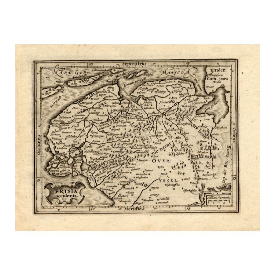
View AllAntique Map of Friesland by Guicciardini, 1613
Located in Langweer, NL
Antique map titled 'Frisia Occidenta.' (Map of the province of Friesland, the Netherlands.) This original old antique print / plate originates from the scarse French edition of 'Desc...
Category
Antique 17th Century Maps
Materials
Paper
$267 Sale Price
20% Off
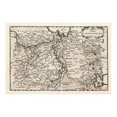
Early Antique Map of Gelderland and Overijssel in the Netherlands, c.1625
Located in Langweer, NL
Antique map titled 'Geldria et Transysulana'.
One of the earliest maps of Gelderland and Overijssel in the Netherlands, prepared by Gerard Mercator.
Artists and Engravers: Gerard...
Category
Antique 17th Century Maps
Materials
Paper

$621 Sale Price
20% Off
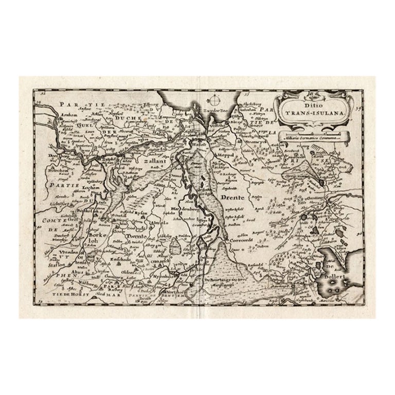
Antique Map of Overijssel by Colom, 1635
Located in Langweer, NL
Antique map titled 'Ditio Trans-Isulana'. Original antique map of the province of Overijssel, the Netherlands. This map originates from 'Vyerige Colom verthonende de 17 Nederlandsche...
Category
Antique 17th Century Maps
Materials
Paper
$210 Sale Price
20% Off
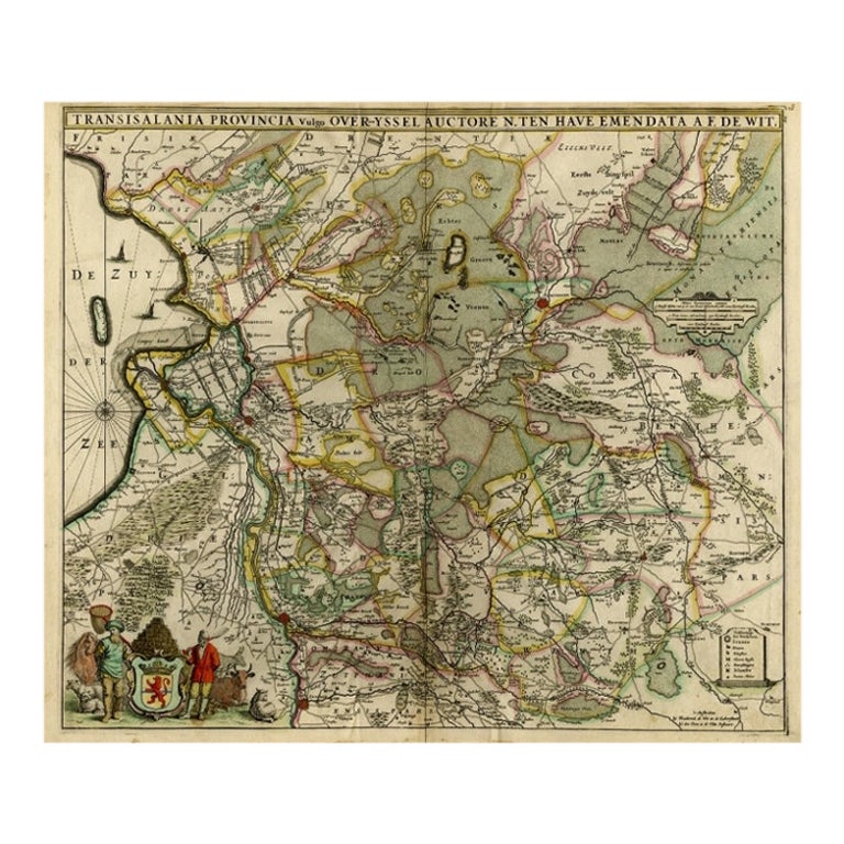
Antique Map of Overijssel by Visscher, c.1652
Located in Langweer, NL
Antique map titled 'Transisalania provincia vulgo Over-yssel'. Original antique map of the province of Overijssel, the Netherlands. Published by N. Visscher after N. ten Have, circa ...
Category
Antique 17th Century Maps
Materials
Paper
$524 Sale Price
20% Off
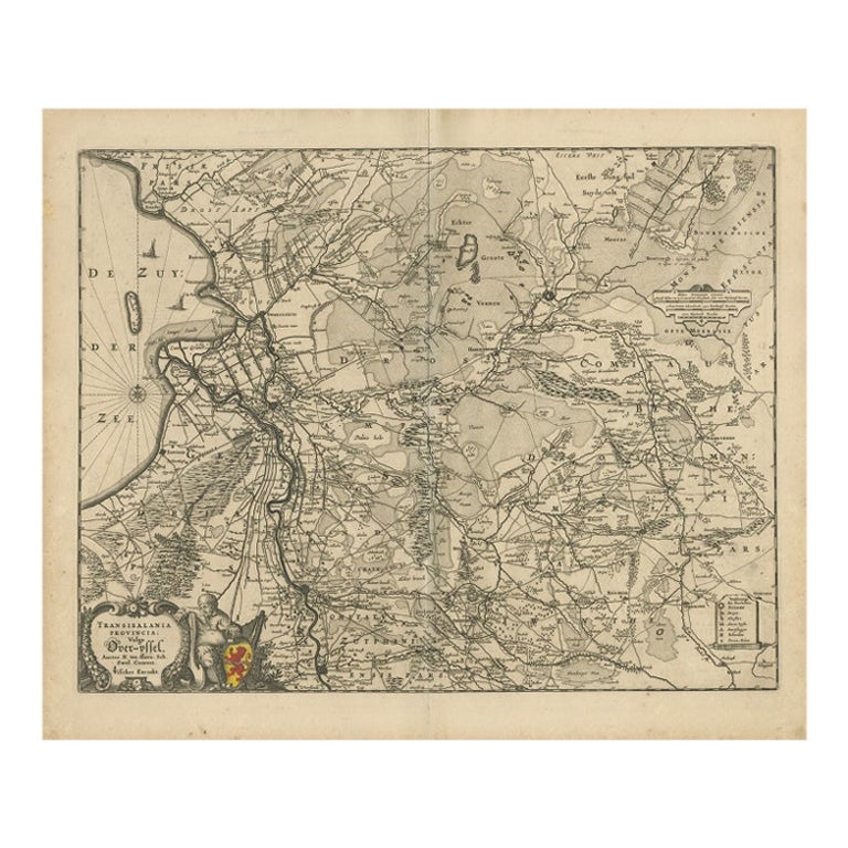
Original Antique Map of the Dutch Provinces of Overijssel and Drenthe, 1635
Located in Langweer, NL
Antique map titled 'Transiselania Dominium vernacule Over-Yssel.' - Map of the Dutch Provinces of Overijssel and Drenthe. Dedicated to Mr. Bartold Wich...
Category
Antique 1630s Maps
Materials
Paper

$459 Sale Price
20% Off
Antique Map of Overijssel by De Wit, c.1680
Located in Langweer, NL
Antique map titled 'Transisalania Provincia Vulgo Over-Yssel'. Original antique map of Overijssel, the Netherlands, showing the regio between Zutphen, Zwolle, Blokzijl, Coevorden, Ol...
Category
Antique 17th Century Maps
Materials
Paper
$425 Sale Price
20% Off
You May Also Like
1635 Willem Blaeu Map of Northern France"Comitatvs Bellovacvm" Ric.a08
Located in Norton, MA
1635 Willem Blaeu map of northern France, entitled.
"Comitatvs Bellovacvm Vernacule Beavvais,"
Colored
Ric.a008
“COMITATVS BELLOVACVM…” Amsterdam: W...
Category
Antique 17th Century Unknown Maps
Materials
Paper

1643 Willem&Joan Blaeu Map NW Flanders "Flandriae Teutonicae Pars Prientalior
Located in Norton, MA
1643 Willem and Joan Blaeu map of northwest Flanders, entitled
"Flandriae Teutonicae Pars Prientalior,"
Ric0012
" Authentic" - Map of the northwest Fl...
Category
Antique 17th Century Dutch Maps
Materials
Paper

1752 Vaugoundy Map of Flanders : Belgium, France, and the Netherlands, Ric.a002
Located in Norton, MA
Large Vaugoundy Map of Flanders:
Belgium, France, and the Netherlands
Colored -1752
Ric.a002
Description: This is a 1752 Didier Robert de Vaugondy map of Flanders. The map de...
Category
Antique 17th Century Unknown Maps
Materials
Paper

1657 Janssonius Map of Vermandois and Cappelle, Ric. A-004
Located in Norton, MA
1657 Janssonius map of
Vermandois and Cappelle
Ric.a004
Description: Antique map of France titled 'Descriptio Veromanduorum - Gouvernement de la Cappelle'. Two detailed maps o...
Category
Antique 17th Century Unknown Maps
Materials
Paper

1620 Map of Artois Entitled "Artesia Comitatvs Artois, " by Bleau, Ric.a012
Located in Norton, MA
1640 map of Artois entitled
"Artesia Comitatvs Artois,"
by Bleau
Colored
A-012.
Detailed map of the northern province of Artois, France on the border with Belgium. Feature...
Category
Antique 17th Century Dutch Maps
Materials
Paper

1590 Ortelius Map of Calais and Vermandois, France and Vicinity Ric.a014
Located in Norton, MA
1590 Ortelius map of
Calais and Vermandois, France and Vicinity
Ric.a014
Two rare regional Abraham Ortelius maps on a single folio sheet. Left map, entitled Caletensium, depic...
Category
Antique 16th Century Dutch Maps
Materials
Paper

More Ways To Browse
Paper Globe Light
William Of Orange
Lancashire Map
16th Century Scotland
Antique Leather Map
Antique Map Of Argentina
Antique Map Of Colombia
Cornwall Map
Early Texas Furniture
Rand Mcnally Vintage Maps
Tunisia Antique Map
Used Office Furniture Rhode Island
Antique Chesapeake Bay Map
Antique Copper Australia
Antique Furniture Pondicherry
Antique Map Of Cornwall
Antique Maps Dublin
Antique Maps Of Malta