Items Similar to Antique Map of Kuinderschans, Part of the Frisian Defense Line, Netherlands 1649


Want more images or videos?
Request additional images or videos from the seller
1 of 5
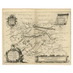
Antique Map of Kuinderschans, Part of the Frisian Defense Line, Netherlands 1649
$172.17
$215.2120% Off
£127.46
£159.3220% Off
€144
€18020% Off
CA$238.24
CA$297.8020% Off
A$262.65
A$328.3220% Off
CHF 137.41
CHF 171.7620% Off
MX$3,222.26
MX$4,027.8220% Off
NOK 1,729.74
NOK 2,162.1720% Off
SEK 1,617.58
SEK 2,021.9720% Off
DKK 1,096.90
DKK 1,371.1320% Off
About the Item
Antique Dutch map titled 'Kuynder-Schans'. Old map of the 'Kuinderschans', a rampart to block passage over the Zuiderzeedijk and prevent an attack from the waterside.
The building of the Friese Waterlinie started around 1580. The Kuinderschans was one of ten 'schansen' or defense walls. The traject of the defenceline starts at the Zuidersea, along the river Linde until the De Blessebridge. Then the defence line goes to the north to Kuinre along Heerenveen, Terband, Gorredijk, Donkerbroek, Bakkeveen until Frieschepalen. The area along the forts, dams were flooded during the Eighty Years' War against the Spanish and in 1672 Rampjaar (Disaster year) against Bernard von Galen and the French troops helping the bishop of Munster. In the east the defence line is connected with the Groninger waterlinie which carries on to Delfzijl. Part of the Frisian Water Line is also called the Tjonger-Lindelinie.
The ten schansen were situated in Schoterland nearby Oudehorne, just north of the river the Tjonger nearby Oudeschoot along the road to Wolvega and nearby Terbant. Currently the defence line is under restoration.
This map originates from 'Atlas van Loon'. Artists and Engravers: The Atlas Van Loon is the extremely sumptuous atlas commissioned by Frederik Willem van Loon from Amsterdam. It contained many maps by Blaeu, Janssonius and Pieter Goos.
Condition: Good, general age-related toning. Some soiling, Dutch text on verso. Please study image carefully.
- Dimensions:Height: 12.41 in (31.5 cm)Width: 20.87 in (53 cm)Depth: 0 in (0.01 mm)
- Materials and Techniques:
- Period:
- Date of Manufacture:1649
- Condition:
- Seller Location:Langweer, NL
- Reference Number:Seller: BG-00394 1stDibs: LU3054326362662
About the Seller
5.0
Recognized Seller
These prestigious sellers are industry leaders and represent the highest echelon for item quality and design.
Platinum Seller
Premium sellers with a 4.7+ rating and 24-hour response times
Established in 2009
1stDibs seller since 2017
2,613 sales on 1stDibs
Typical response time: <1 hour
- ShippingRetrieving quote...Shipping from: Langweer, Netherlands
- Return Policy
Authenticity Guarantee
In the unlikely event there’s an issue with an item’s authenticity, contact us within 1 year for a full refund. DetailsMoney-Back Guarantee
If your item is not as described, is damaged in transit, or does not arrive, contact us within 7 days for a full refund. Details24-Hour Cancellation
You have a 24-hour grace period in which to reconsider your purchase, with no questions asked.Vetted Professional Sellers
Our world-class sellers must adhere to strict standards for service and quality, maintaining the integrity of our listings.Price-Match Guarantee
If you find that a seller listed the same item for a lower price elsewhere, we’ll match it.Trusted Global Delivery
Our best-in-class carrier network provides specialized shipping options worldwide, including custom delivery.More From This Seller
View AllAntique Map of The Siege of Gennep, the Netherlands, c.1650
Located in Langweer, NL
Antique map titled 'Belagerung des Besten Schloss und Passes Gennep'. Old map of the Siege of Gennep, the Netherlands. This map originates from 'Theatrum Europaeum' by M. Merian. Art...
Category
Antique 17th Century Maps
Materials
Paper

$229 Sale Price
20% Off
Antique Map of the Region of Dantumadeel, Friesland, The Netherlands, 1664
Located in Langweer, NL
Antique map titled 'De Grietenije van Dantuma deel (..)'. Map of the Grietenij of Dantumadeel, Friesland, The Netherlands. Multiple cartouches, key and coat of arms. Originates from ...
Category
Antique 17th Century Maps
Materials
Paper
$186 Sale Price
20% Off
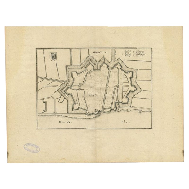
Antique Map of the City of Gorinchem by Merian, 1659
Located in Langweer, NL
Antique map titled 'Gorckum'. This print depicts the city of Gorinchem (or Gorcum/Gorkum, The Netherlands). This print originates from 'Topographia Germaniae Inferioris (..)' by C. M...
Category
Antique 17th Century Maps
Materials
Paper
$94 Sale Price
20% Off
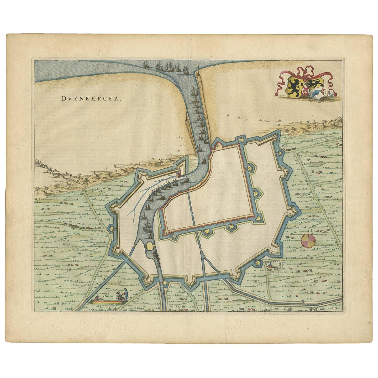
Antique Map of Dunkirk 'France' by J. Blaeu, 1649
Located in Langweer, NL
Antique map titled 'Duynkercka'. Published by J. Blaeu, 1649. Dutch text on verso.
Category
Antique Mid-17th Century Maps
Materials
Paper

$502 Sale Price
20% Off
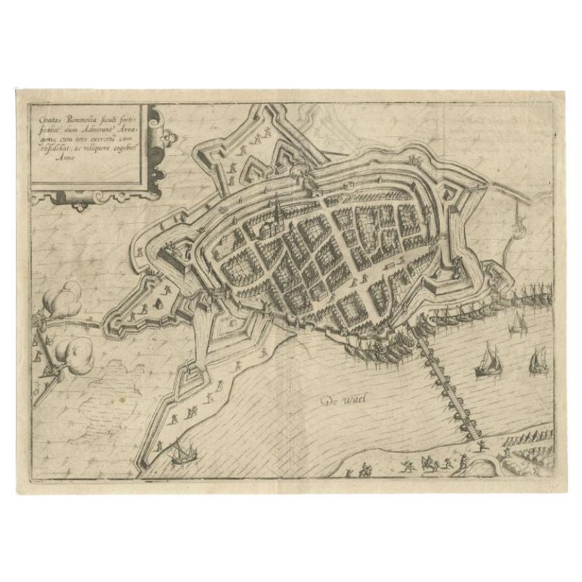
Antique Map of Zaltbommel in the Netherlands, by Guicciardini, 1613
Located in Langweer, NL
Antique print titled 'Civitas Bommelia (..)'. Beautiful plan of Zaltbommel, Gelderland (the Netherlands). This map originates from 'Discrittione di tutti i Paesi Bassi' by L. Guiccia...
Category
Antique 17th Century Maps
Materials
Paper
$363 Sale Price
20% Off
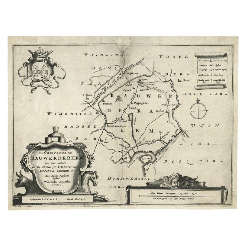
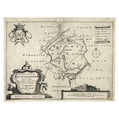
Antique Map of the Region of Rauwerderhem, Friesland, The Netherlands, '1664'
By B. Schotanus
Located in Langweer, NL
Antique map titled 'De Grietenije van Rauwerderhem (..).' Map of the Grietenij of Rauwerderhem, Friesland, The Netherlands. Multiple cartouches, key and coat of arms. This map orgini...
Category
Antique 17th Century Maps
Materials
Paper
You May Also Like
Map of the Netherlands - Etching by G. Braun and F. Hogenberg -Late 16th Century
By Franz Hogenberg
Located in Roma, IT
Map of the Netherlands is an original etching realized by George Braun and Franz Hogenberg, as part of the "Civitates Orbis Terrarum".
The “Civitates Orbis Terrarum” (Atlas of Citi...
Category
16th Century Figurative Prints
Materials
Etching

1643 Willem&Joan Blaeu Map NW Flanders "Flandriae Teutonicae Pars Prientalior
Located in Norton, MA
1643 Willem and Joan Blaeu map of northwest Flanders, entitled
"Flandriae Teutonicae Pars Prientalior,"
Ric0012
" Authentic" - Map of the northwest Fl...
Category
Antique 17th Century Dutch Maps
Materials
Paper

1630 Pierre Petit map "Description du Gouvernement de la Capelle" Ric0010
Located in Norton, MA
1630 Pierre Petit map entitled
"Description du Gouvernement de la Capelle,"
Ric0010
Pierre Petit was the son of a minor provincial official in Montluçon. The town, in the Auver...
Category
Antique 17th Century Dutch Maps
Materials
Paper

Map of Kampen, Netherlands - by G. Braun and F. Hogenberg - Late 16th Century
By Franz Hogenberg
Located in Roma, IT
This map of Kampen (the ancient Campensis) is an original etching realized by George Braun and Franz Hogenberg as part of the famous Series "Civitates Orbis Terrarum".
The “Civita...
Category
16th Century Figurative Prints
Materials
Etching

Utrecht, Antique Map from "Civitates Orbis Terrarum"
By Franz Hogenberg
Located in Roma, IT
Braun G., Hogenberg F., Traiectum or Utrecht, from the collection Civitates Orbis Terrarum, Cologne, T. Graminaeus, 1572-1617.
Very fine B/W aquatint showing a view of Utrecht, with...
Category
16th Century Landscape Prints
Materials
Etching

Map of Nijmegen - Etching by G. Braun and F. Hogenberg - Late 16th Century
By Franz Hogenberg
Located in Roma, IT
This map of Noviomagvs is an original etching realized by Georg Braun and Franz Hogenberg as part of the famous series "Civitates Orbis Terrarum".
The state of preservation of the ...
Category
16th Century Figurative Prints
Materials
Etching
