Items Similar to Antique Map of the Region of Franche-Comté by Janssonius, circa 1650


Want more images or videos?
Request additional images or videos from the seller
1 of 5
Antique Map of the Region of Franche-Comté by Janssonius, circa 1650
$572.60
$715.7520% Off
£423.33
£529.1620% Off
€480
€60020% Off
CA$787.60
CA$984.5020% Off
A$875.47
A$1,094.3320% Off
CHF 458.90
CHF 573.6320% Off
MX$10,691.55
MX$13,364.4420% Off
NOK 5,729.10
NOK 7,161.3820% Off
SEK 5,390.02
SEK 6,737.5220% Off
DKK 3,654.23
DKK 4,567.7920% Off
About the Item
Antique map titled 'Burgundiae Comitatus Franche Comté'. Old map of the historical and former region of Franche-Comté, France. As a region, it encompassed the eastern departements of Jura, Doubs, Haute-Saône, and the Territoire de Belfort. It shows the bordering region of Switzerland including Geneva. Published by Janssonius, circa 1650.
- Dimensions:Height: 19.49 in (49.5 cm)Width: 23.04 in (58.5 cm)Depth: 0.02 in (0.5 mm)
- Materials and Techniques:
- Period:Mid-17th Century
- Date of Manufacture:circa 1650
- Condition:Original/contemporary hand coloring. Latin text on verso. Some creasing and minor defects, please study images carefully.
- Seller Location:Langweer, NL
- Reference Number:Seller: BG-12380-101stDibs: LU3054317821702
About the Seller
5.0
Recognized Seller
These prestigious sellers are industry leaders and represent the highest echelon for item quality and design.
Platinum Seller
Premium sellers with a 4.7+ rating and 24-hour response times
Established in 2009
1stDibs seller since 2017
2,604 sales on 1stDibs
Typical response time: <1 hour
- ShippingRetrieving quote...Shipping from: Langweer, Netherlands
- Return Policy
Authenticity Guarantee
In the unlikely event there’s an issue with an item’s authenticity, contact us within 1 year for a full refund. DetailsMoney-Back Guarantee
If your item is not as described, is damaged in transit, or does not arrive, contact us within 7 days for a full refund. Details24-Hour Cancellation
You have a 24-hour grace period in which to reconsider your purchase, with no questions asked.Vetted Professional Sellers
Our world-class sellers must adhere to strict standards for service and quality, maintaining the integrity of our listings.Price-Match Guarantee
If you find that a seller listed the same item for a lower price elsewhere, we’ll match it.Trusted Global Delivery
Our best-in-class carrier network provides specialized shipping options worldwide, including custom delivery.More From This Seller
View AllAntique Map of the Alsace Region of France by Janssonius, c.1650
Located in Langweer, NL
Antique map titled 'Utriusquae Alsatiae Superioris Ac Inferioris Nova Tabula'. Map of the Alsace region (France) including the Rhine from Phillipsburg to south of Basle. Two decorati...
Category
Antique 17th Century Maps
Materials
Paper
$314 Sale Price
20% Off
Antique Map of the Region of Lyonnais by Janssonius, '1657'
By Johannes Janssonius
Located in Langweer, NL
Antique map 'Lionnois, forest, beauviolois et masconnois'. Decorative map of the Lyonnais region, France. The Lyonnais is a historical province of France which owes its name to the c...
Category
Antique Mid-17th Century Maps
Materials
Paper

$477 Sale Price
20% Off
Antique Map of the Region of Lyon by Hondius, circa 1630
Located in Langweer, NL
Antique map titled 'Lionnois, Forest et Beauiolois'. Old map of the former region of Lyon, Vienne, Bresse, Rohan and the Rhône River. This map originates f...
Category
Antique Mid-17th Century Maps
Materials
Paper

$477 Sale Price
20% Off
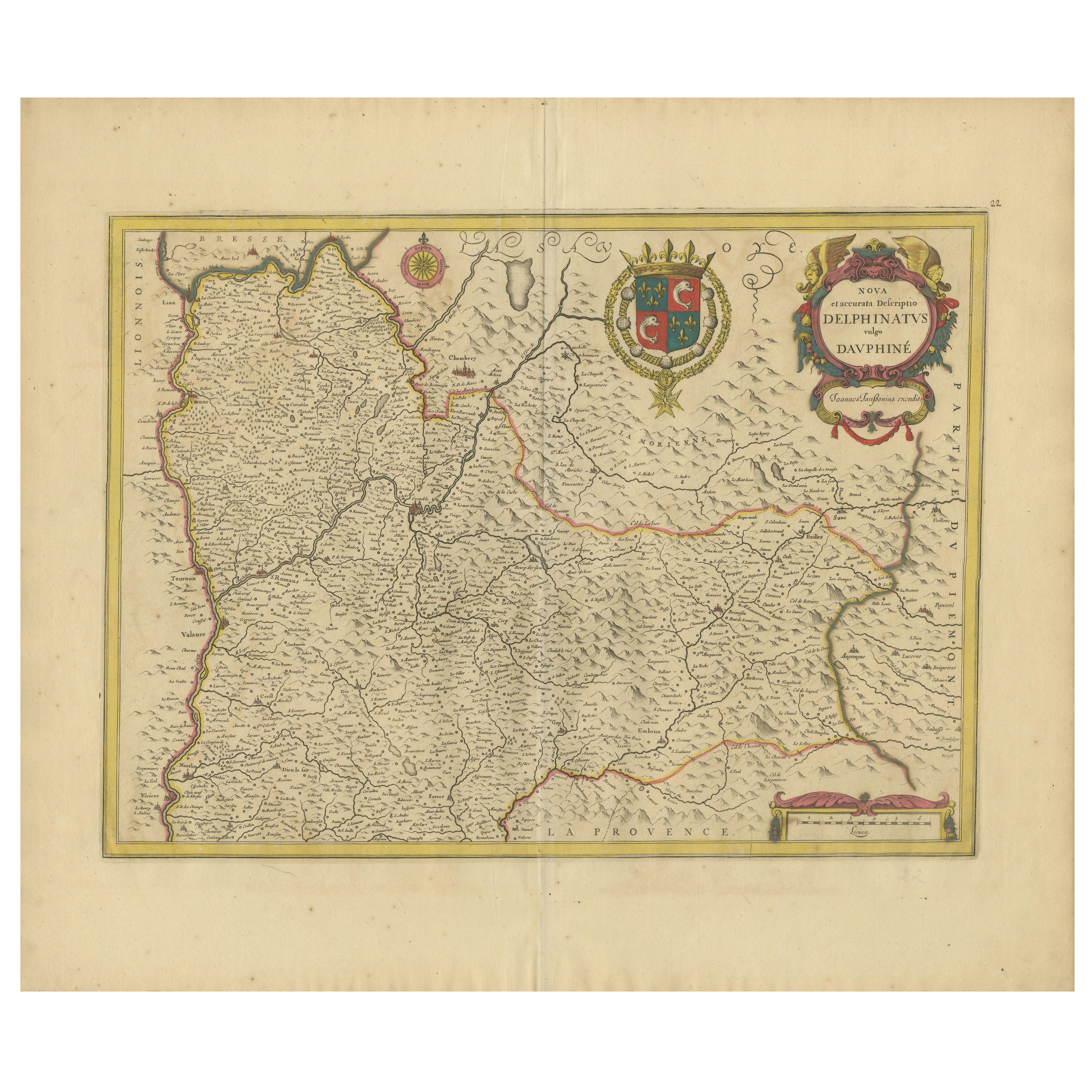
Rare 17th-Century Map of Dauphiné in Southeastern France by F. De Wit, ca.1688
Located in Langweer, NL
Title: Rare Hand-Colored 17th-Century Map of Dauphiné by Frederik De Wit c. 1688
Description: This captivating 17th-century map of Dauphiné, titled "Nova et Accurata Delphinatus Vul...
Category
Antique 1680s Maps
Materials
Paper

Antique Map of the Region of Saintonge by Janssonius, 1657
By Johannes Janssonius
Located in Langweer, NL
Antique map 'La Saintonge vers le Midy avecq le Brovageais'. Decorative map of the Saintonge region, a former province of France located on the west central Atlantic coast. This map ...
Category
Antique Mid-17th Century Maps
Materials
Paper

$572 Sale Price
20% Off
Antique Map of the Region of Périgord by Janssonius, 1657
By Johannes Janssonius
Located in Langweer, NL
Antique map of France titled 'Le Comte de Perigort'. Decorative map of the Périgord region. Périgord is a natural region and former province of France, which corresponds roughly to t...
Category
Antique 17th Century Maps
Materials
Paper

$337 Sale Price
20% Off
You May Also Like
1640 Joan Bleau Map Entitled"Diocecese de rheims et le pais de rethel, " Eic.a011
Located in Norton, MA
1640 Joan Bleau map entitled
"Diocecese de rheims et le pais de rethel,"
Ric.a011
OAN BLAEU
Diocecese de Rheims, et le pais de Rethel.
Handcolored engraving, c.1640.
...
Category
Antique 17th Century Dutch Maps
Materials
Paper

1657 Janssonius Map of Vermandois and Cappelle, Ric. A-004
Located in Norton, MA
1657 Janssonius map of
Vermandois and Cappelle
Ric.a004
Description: Antique map of France titled 'Descriptio Veromanduorum - Gouvernement de la Cappelle'. Two detailed maps o...
Category
Antique 17th Century Unknown Maps
Materials
Paper

1625 Mercator Map of the Provenience of Quercy, "Quercy Cadvrcivm Ric.0013
Located in Norton, MA
1625 Mercator map of the provenience of Quercy, entitled
"Quercy Cadvrcivm,"
Ric.0013
" Authentic" - Map of the provenience of Quercy Cadvrcivm
D...
Category
Antique 17th Century French Maps
Materials
Paper

1635 Willem Blaeu Map of Northern France"Comitatvs Bellovacvm" Ric.a08
Located in Norton, MA
1635 Willem Blaeu map of northern France, entitled.
"Comitatvs Bellovacvm Vernacule Beavvais,"
Colored
Ric.a008
“COMITATVS BELLOVACVM…” Amsterdam: W...
Category
Antique 17th Century Unknown Maps
Materials
Paper

1656 Jansson Map Metz Region of France Entitled "Territorium Metense" Ric0014
Located in Norton, MA
1656 Jansson map Metz Region of France entitled "Territorium Metense."
Ric0014
" Authentic" - Map of the historical region surrounding Metz, in Lorraine, France.
Oriented with ...
Category
Antique 17th Century Dutch Maps
Materials
Paper

1590 Mercator Map Entitled "France Picardie Champaigne, Ric.0001
Located in Norton, MA
Description: Published in Amsterdam by Mercator/Hondius ca. 1590.
Ric.0001
Artists and Engravers: Map : 'France Picardie Champaigne cum regionibus adiacentibus'. (Map of the french provinces of Picardie and Champagne.) Copper engraved map of the french provinces of Picardie and Champagne, showing the cities of Caen, Paris, Melun, Auxerre, Verdun, etc. Copperplate engraving on verge type hand laid paper with watermark. Description: Published in Amsterdam by Mercator/Hondius ca. 1600.Artists and Engravers: Mercator was born in Rupelmonde in Flanders and studied in Louvain under Gemma Frisius, Dutch writer, astronomer and mathematician. The excellence of his work brought him the patronage of Charles V, but in spite of his favor with the Emperor he was caught up in the persecution of Lutheran protestants and charged with heresy, fortunately without serious consequences. No doubt the fear of further persecution influenced his move in 1552 to Duisburg, where he continued the production of maps, globes and instruments. Mercator's sons and grandsons, were all cartographers and made their contributions in various ways to his atlas. Rumold, in particular, was responsible for the complete edition in 1595. The map plates...
Category
Antique 16th Century Dutch Maps
Materials
Paper

More Ways To Browse
Swiss Antiques And Collectables
Antique Map Of Switzerland
Antique Maps Of Italy
Antique Map India
Antique Topographic Maps
Antique Railroad
Antique Maps Of Africa
Railroad Furniture
Antiques Compasses
Antique House Plans
Antique Navigation
Colonial Furniture Company
Mississippi Furniture
Antique Scottish Wood Furniture
Indonesia Map
Antique Framed Map Engravings
Atlas Furniture Company
Used Office Furniture Edinburgh