Items Similar to Antique Map of the West-Frisian Part of Independant Friesland by Halma, 1718


Want more images or videos?
Request additional images or videos from the seller
1 of 7
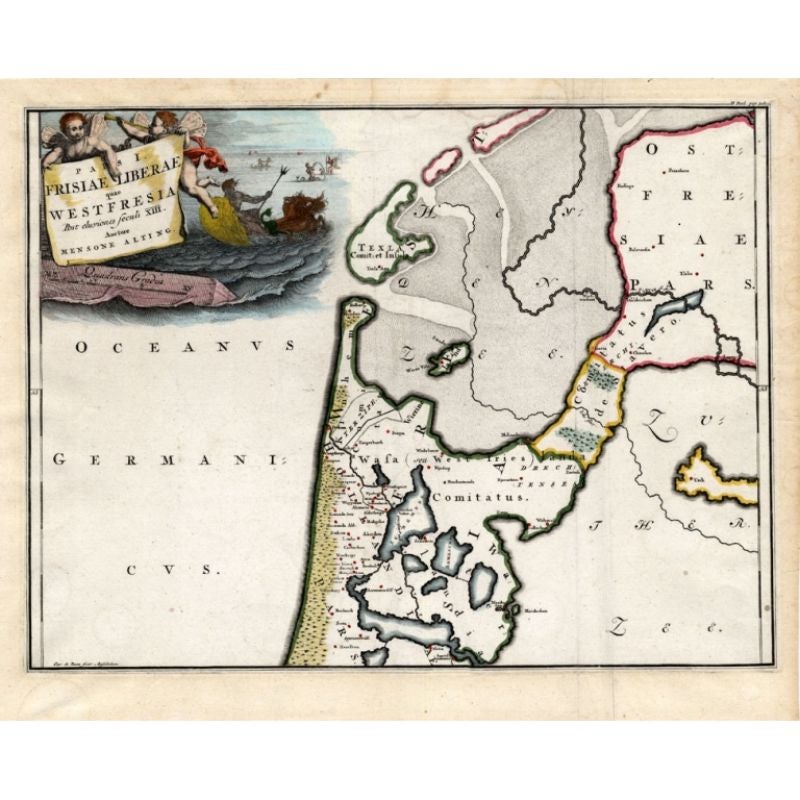
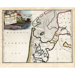
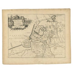
Antique Map of the West-Frisian Part of Independant Friesland by Halma, 1718
$219.90
£163.75
€185
CA$303.60
A$336.58
CHF 176.89
MX$4,119.20
NOK 2,209.13
SEK 2,073.49
DKK 1,408.53
About the Item
Antique map Friesland titled 'Pars I Frisiae Liberae (..)'. Old map of Friesland, the Netherlands. This map depicts the West-Frisian part of independant Friesland. Originates from 'Uitbeelding van de Heerlijkheid van Friesland' by Bernardus Schotanus à Sterringa. This atlas is considered the best atlas of Friesland, the Netherlands.
Artists and Engravers: Published by F. Halma, Leeuwarden.
Condition: Fine. General age related toning and occasional light staining from handling. Please study image carefully.
Date: 1718
Overall size: 64 x 54.5 cm.
Image size: 57 x 32 cm.
We sell original antique maps to collectors, historians, educators and interior decorators all over the world. Our collection includes a wide range of authentic antique maps from the 16th to the 20th centuries. Buying and collecting antique maps is a tradition that goes back hundreds of years. Antique maps have proved a richly rewarding investment over the past decade, thanks to a growing appreciation of their unique historical appeal. Today the decorative qualities of antique maps are widely recognized by interior designers who appreciate their beauty and design flexibility. Depending on the individual map, presentation, and context, a rare or antique map can be modern, traditional, abstract, figurative, serious or whimsical. We offer a wide range of authentic antique maps for any budget.
- Dimensions:Height: 21.46 in (54.5 cm)Width: 25.2 in (64 cm)Depth: 0 in (0.01 mm)
- Materials and Techniques:
- Period:
- Date of Manufacture:1718
- Condition:Condition: Fine. General age related toning and occasional light staining from handling. Please study image carefully.
- Seller Location:Langweer, NL
- Reference Number:Seller: PCT-113841stDibs: LU3054329297992
About the Seller
5.0
Recognized Seller
These prestigious sellers are industry leaders and represent the highest echelon for item quality and design.
Platinum Seller
Premium sellers with a 4.7+ rating and 24-hour response times
Established in 2009
1stDibs seller since 2017
2,609 sales on 1stDibs
Typical response time: <1 hour
- ShippingRetrieving quote...Shipping from: Langweer, Netherlands
- Return Policy
Authenticity Guarantee
In the unlikely event there’s an issue with an item’s authenticity, contact us within 1 year for a full refund. DetailsMoney-Back Guarantee
If your item is not as described, is damaged in transit, or does not arrive, contact us within 7 days for a full refund. Details24-Hour Cancellation
You have a 24-hour grace period in which to reconsider your purchase, with no questions asked.Vetted Professional Sellers
Our world-class sellers must adhere to strict standards for service and quality, maintaining the integrity of our listings.Price-Match Guarantee
If you find that a seller listed the same item for a lower price elsewhere, we’ll match it.Trusted Global Delivery
Our best-in-class carrier network provides specialized shipping options worldwide, including custom delivery.More From This Seller
View AllAntique Map of the West-Frisian part of independent Friesland by Halma, 1718
Located in Langweer, NL
Antique map Friesland titled 'ars I. Frisiae Liberae quae Westfresia post eluviones seculi XIII (..)'. Old map of the West-Frisian part of the independent Friesland, the Netherlands ...
Category
Antique 18th Century Maps
Materials
Paper
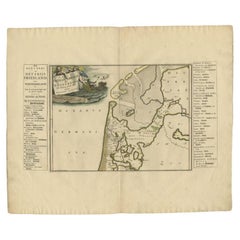
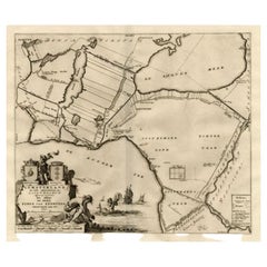
Antique Map of Westfriesland in Ancient Times by Alting, 1697
Located in Langweer, NL
Antique map titled 'Frisiae Liberae quae Westfresia Post eluviones seculi XIII'. Map of Westfriesland in ancient times. This copper engraved map shows part of Holland as it was in an...
Category
Antique 17th Century Maps
Materials
Paper
$161 Sale Price
20% Off
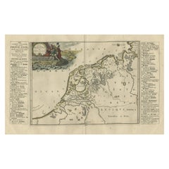
Antique Map of Friesland During Its Widest Spread, 1718
Located in Langweer, NL
Antique map Friesland titled 'Summaria descriptio Fresiae Universae (..)'. Old map of Friesland, the Netherlands. Depicts the general delineation of Friesland during its widest sprea...
Category
Antique 18th Century Maps
Materials
Paper
$209 Sale Price
20% Off
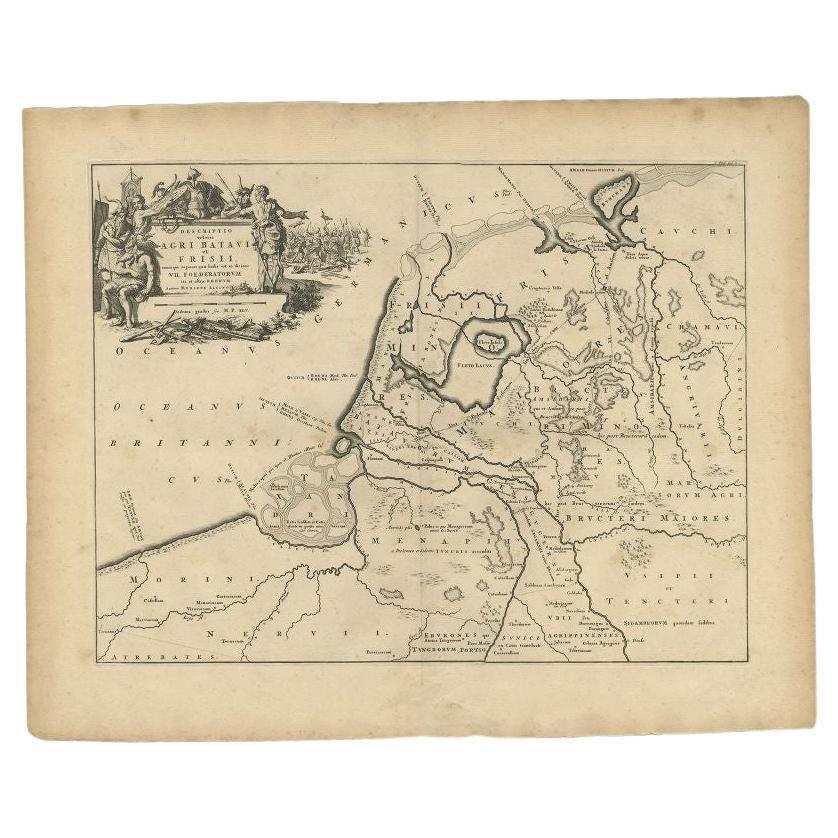
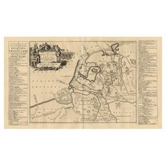
Antique Map of the Old Land of Batavia and Friesland by Halma, 1718
Located in Langweer, NL
Antique map Friesland titled 'Descriptio veteris Agri Batavi et Frisii (..)'. Old map of Friesland, the Netherlands. This map depicts the old land of Batavia and Friesland. Originate...
Category
Antique 18th Century Maps
Materials
Paper
$218 Sale Price
20% Off
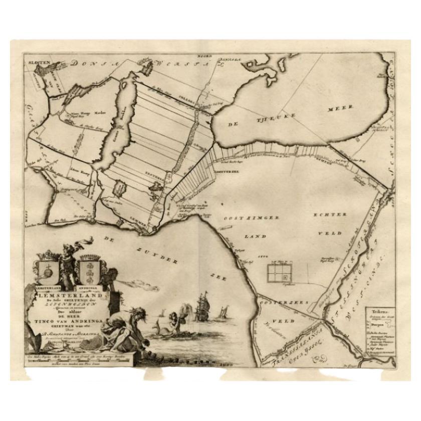
Antique Map of the Lemsterland Township 'Friesland' by Halma, 1718
Located in Langweer, NL
Antique map Friesland titled 'Lemsterland de Seste Grietenije der Zevenwolden (..)'. Old map of Friesland, the Netherlands. This map depicts the region of Lemsterland and includes ci...
Category
Antique 18th Century Maps
Materials
Paper
$231 Sale Price
20% Off
Antique Map of the Old Land of Batavia and FriesLand, The Netherlands, 1697
Located in Langweer, NL
Antique map Friesland titled 'Descriptio veteris Agri Batavi et Frisii (..)'. Old map of Friesland, the Netherlands. Depicts the old land of Batavia and Friesland. This map originate...
Category
Antique 17th Century Maps
Materials
Paper
$179 Sale Price
20% Off
You May Also Like
1643 Willem&Joan Blaeu Map NW Flanders "Flandriae Teutonicae Pars Prientalior
Located in Norton, MA
1643 Willem and Joan Blaeu map of northwest Flanders, entitled
"Flandriae Teutonicae Pars Prientalior,"
Ric0012
" Authentic" - Map of the northwest Fl...
Category
Antique 17th Century Dutch Maps
Materials
Paper

1752 Vaugoundy Map of Flanders : Belgium, France, and the Netherlands, Ric.a002
Located in Norton, MA
Large Vaugoundy Map of Flanders:
Belgium, France, and the Netherlands
Colored -1752
Ric.a002
Description: This is a 1752 Didier Robert de Vaugondy map of Flanders. The map de...
Category
Antique 17th Century Unknown Maps
Materials
Paper

1627 Hendrik Hondius Map Entitled "Vltoniae Orientalis Pars, " Ric.a009
Located in Norton, MA
1627 Hendrik Hondius map entitled
"Vltoniae orientalis pars,"
Ric.a009
Title:
Vltoniae orientalis : pars
Title (alt.) :
Ultoniae orientalis pars
Creator:
Mercator, Gerh...
Category
Antique 17th Century Dutch Maps
Materials
Paper

Map of the Netherlands - Etching by G. Braun and F. Hogenberg -Late 16th Century
By Franz Hogenberg
Located in Roma, IT
Map of the Netherlands is an original etching realized by George Braun and Franz Hogenberg, as part of the "Civitates Orbis Terrarum".
The “Civitates Orbis Terrarum” (Atlas of Citi...
Category
16th Century Figurative Prints
Materials
Etching

North Holland, Netherlands: A Large 17th C. Hand-colored Map by Sanson & Jaillot
By Nicholas Sanson d'Abbeville
Located in Alamo, CA
This large hand-colored map entitled "Le Comte De Hollande Dressee sur les Memoires les plus Nouveaux" was originally created by Nicholas Sanson d'Abbeville. This version was publish...
Category
1690s Landscape Prints
Materials
Engraving

Rare Original Map of New Amsterdam (New York) – “Restitutio”, ca. 1674 –
Located in Dronten, NL
An exceptionally rare and original 17th-century engraving of New Amsterdam, now New York City, published by the renowned Amsterdam cartographer Carel (Carolus) Allard around 1674. Kn...
Category
Antique 17th Century Dutch Maps
Materials
Paper

More Ways To Browse
Antique Maps Massachusetts
Guyana Antique Map
Peninsular War
Santa Cruz Island
Ukraine Antique Map
Antique Life Buoy
Antique Map Nova Scotia
Antique Map Of Argentina
Antique Maps Of Kansas
Cambodia Antique Map
Magellan Map
Map Ukraine
Mariners Chart
Papua New Guinea Antique Map
Bermuda Map
Scan Globe
Tunisia Antique Map
Antique Map New Orleans