Items Similar to Attractive Small Map of the British Isles with Decorative Cartouche

Want more images or videos?
Request additional images or videos from the seller
1 of 6
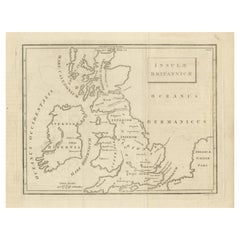
Attractive Small Map of the British Isles with Decorative Cartouche
$248.14
$310.1720% Off
£183.43
£229.2820% Off
€208
€26020% Off
CA$344.18
CA$430.2220% Off
A$375.23
A$469.0420% Off
CHF 198.26
CHF 247.8320% Off
MX$4,614.44
MX$5,768.0520% Off
NOK 2,465.25
NOK 3,081.5620% Off
SEK 2,320.71
SEK 2,900.8820% Off
DKK 1,583.81
DKK 1,979.7720% Off
About the Item
Antique map titled 'Isles Britaniques ou sont les Royaumes d'Angleterre, D'Escosse et d'Irlande'. Attractive small map of the British Isles with decorative cartouche. Published circa 1705.
- Dimensions:Height: 6.38 in (16.2 cm)Width: 7.6 in (19.3 cm)Depth: 0.02 in (0.5 mm)
- Materials and Techniques:
- Period:
- Date of Manufacture:c.1705
- Condition:General age-related toning. Original folding lines. Shows some wear and soiling, blank verso. Please study image carefully.
- Seller Location:Langweer, NL
- Reference Number:Seller: BG-13396-61stDibs: LU3054333735052
About the Seller
5.0
Recognized Seller
These prestigious sellers are industry leaders and represent the highest echelon for item quality and design.
Platinum Seller
Premium sellers with a 4.7+ rating and 24-hour response times
Established in 2009
1stDibs seller since 2017
2,620 sales on 1stDibs
Typical response time: <1 hour
- ShippingRetrieving quote...Shipping from: Langweer, Netherlands
- Return Policy
Authenticity Guarantee
In the unlikely event there’s an issue with an item’s authenticity, contact us within 1 year for a full refund. DetailsMoney-Back Guarantee
If your item is not as described, is damaged in transit, or does not arrive, contact us within 7 days for a full refund. Details24-Hour Cancellation
You have a 24-hour grace period in which to reconsider your purchase, with no questions asked.Vetted Professional Sellers
Our world-class sellers must adhere to strict standards for service and quality, maintaining the integrity of our listings.Price-Match Guarantee
If you find that a seller listed the same item for a lower price elsewhere, we’ll match it.Trusted Global Delivery
Our best-in-class carrier network provides specialized shipping options worldwide, including custom delivery.More From This Seller
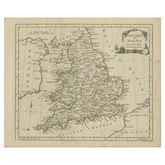
View AllOriginal Antique Map of England and Wales, with Decorative Cartouche
Located in Langweer, NL
Antique map titled 'England and Wales from the best Authorities'. Original antique map of England and Wales, with decorative cartouche. Engraved by T. Conder. Published circa 1790.
Category
Antique Late 18th Century Maps
Materials
Paper
$152 Sale Price
20% Off
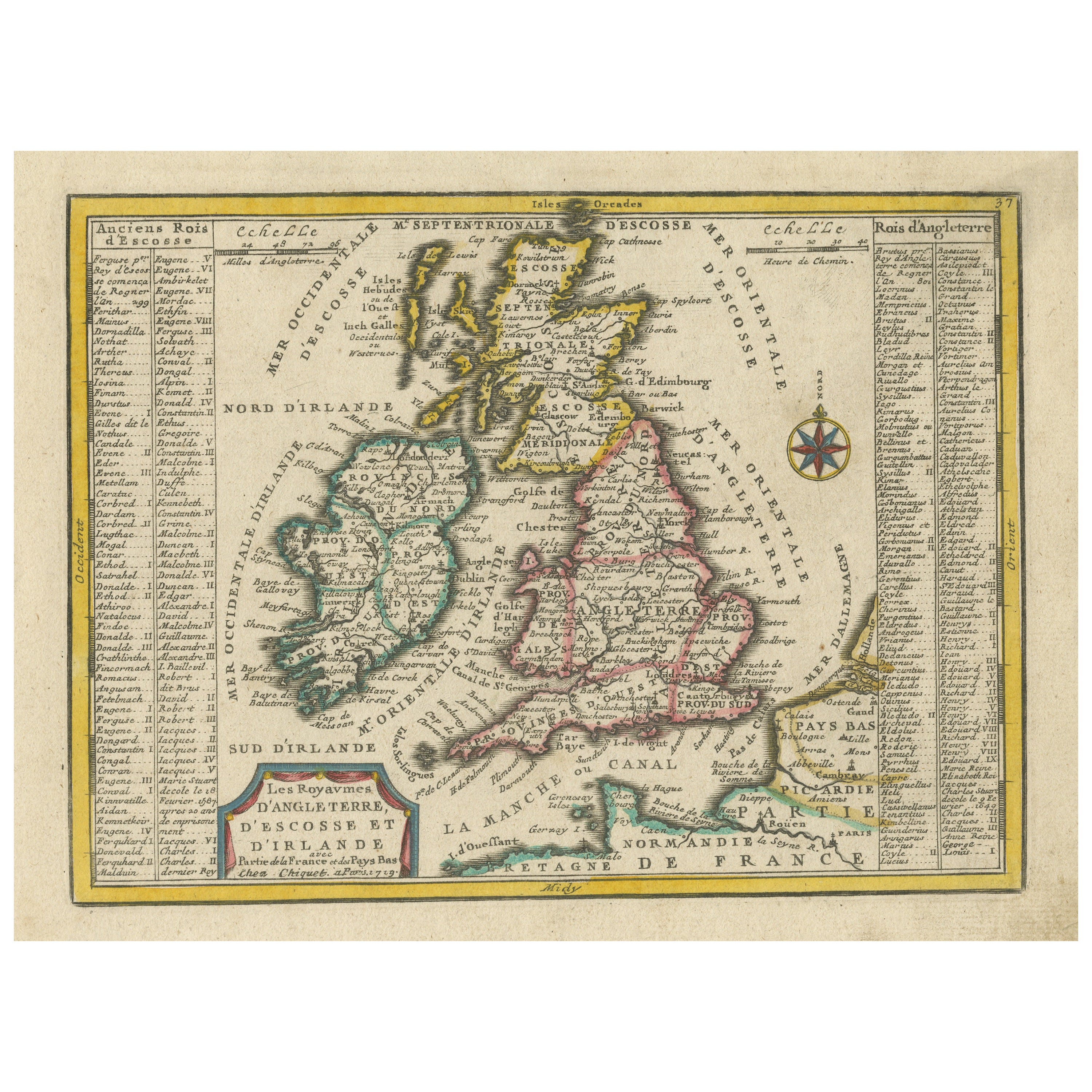
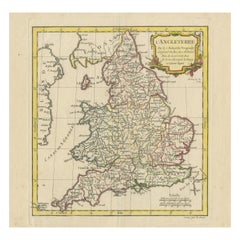
Small Antique Map of England, Wales, Scotland and Ireland with Original Coloring
Located in Langweer, NL
Antique map titled 'Les Royaumes d'Angleterre d'Escosse et d'Irlande (..)'. A lovely, small map of England, Wales, Scotland and Ireland with a portion of the coastline of France and ...
Category
Antique Early 18th Century Maps
Materials
Paper

$439 Sale Price
20% Off
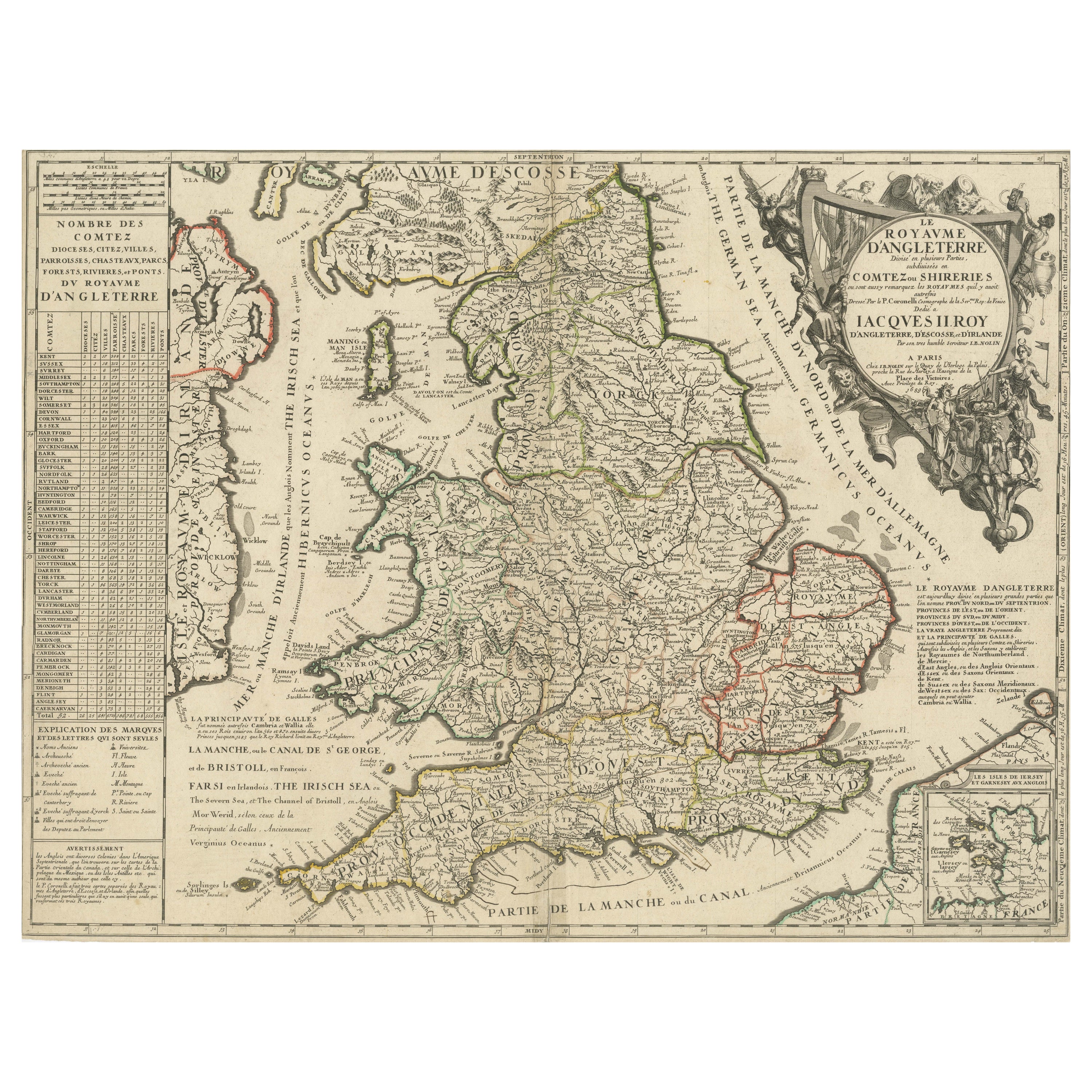
Original Antique Map of England and Wales with Large Cartouche
Located in Langweer, NL
Antique map titled 'Le Royaume d'Angleterre divisé en plusieurs Parties (..)'. Large and rare map of England and Wales by J.B. Nolin after Coronelli. With decorative cartouche, table...
Category
Antique Late 17th Century Maps
Materials
Paper

$419 Sale Price
20% Off
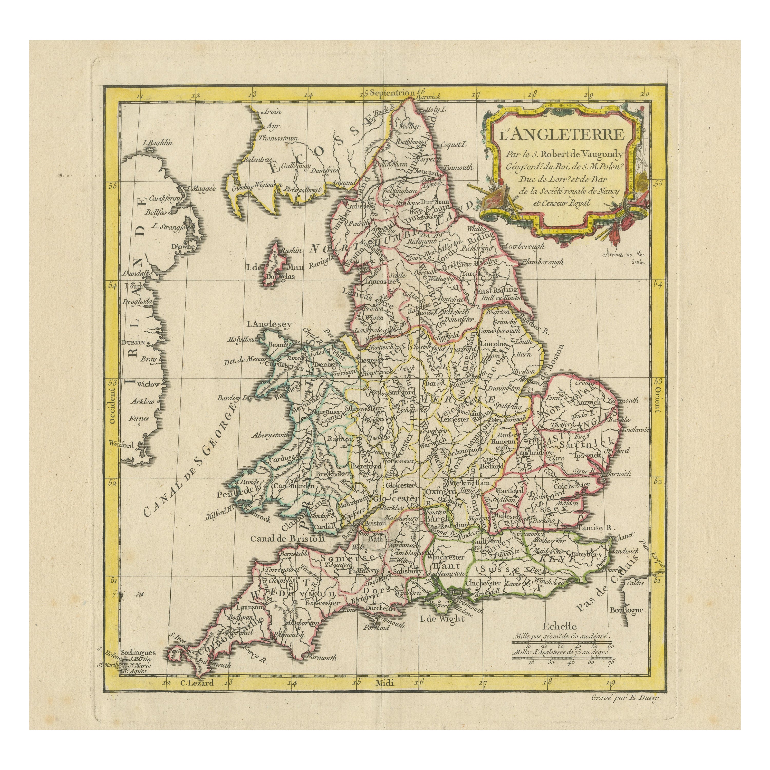
Original Antique Map of England with Decorative Cartouche
Located in Langweer, NL
Antique map titled 'l'Angleterre (..)'. Original antique map of England, with beautiful hand coloring and decorative cartouche. This map originates from 'Nouvel Atlas Portatif destin...
Category
Antique Late 18th Century Maps
Materials
Paper
$276 Sale Price
20% Off
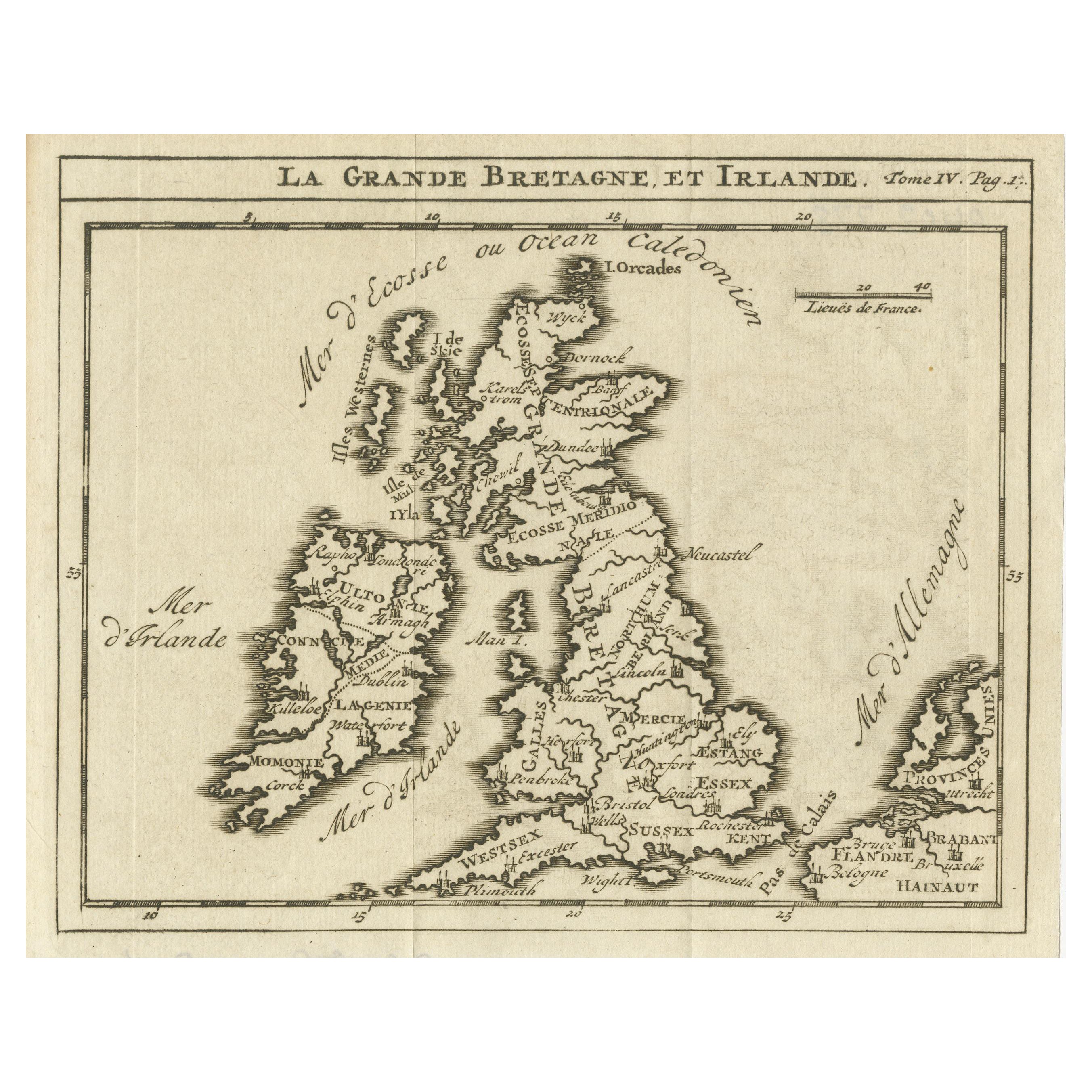
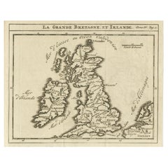
Rare Small Antique Map of Great Britain and Ireland
Located in Langweer, NL
Antique map titled 'La Grande Bretagne et Irlande'. Small antique map of Great Britain and Ireland. Source unknown, to be determined. Publ...
Category
Antique Mid-18th Century Maps
Materials
Paper
$219 Sale Price
20% Off
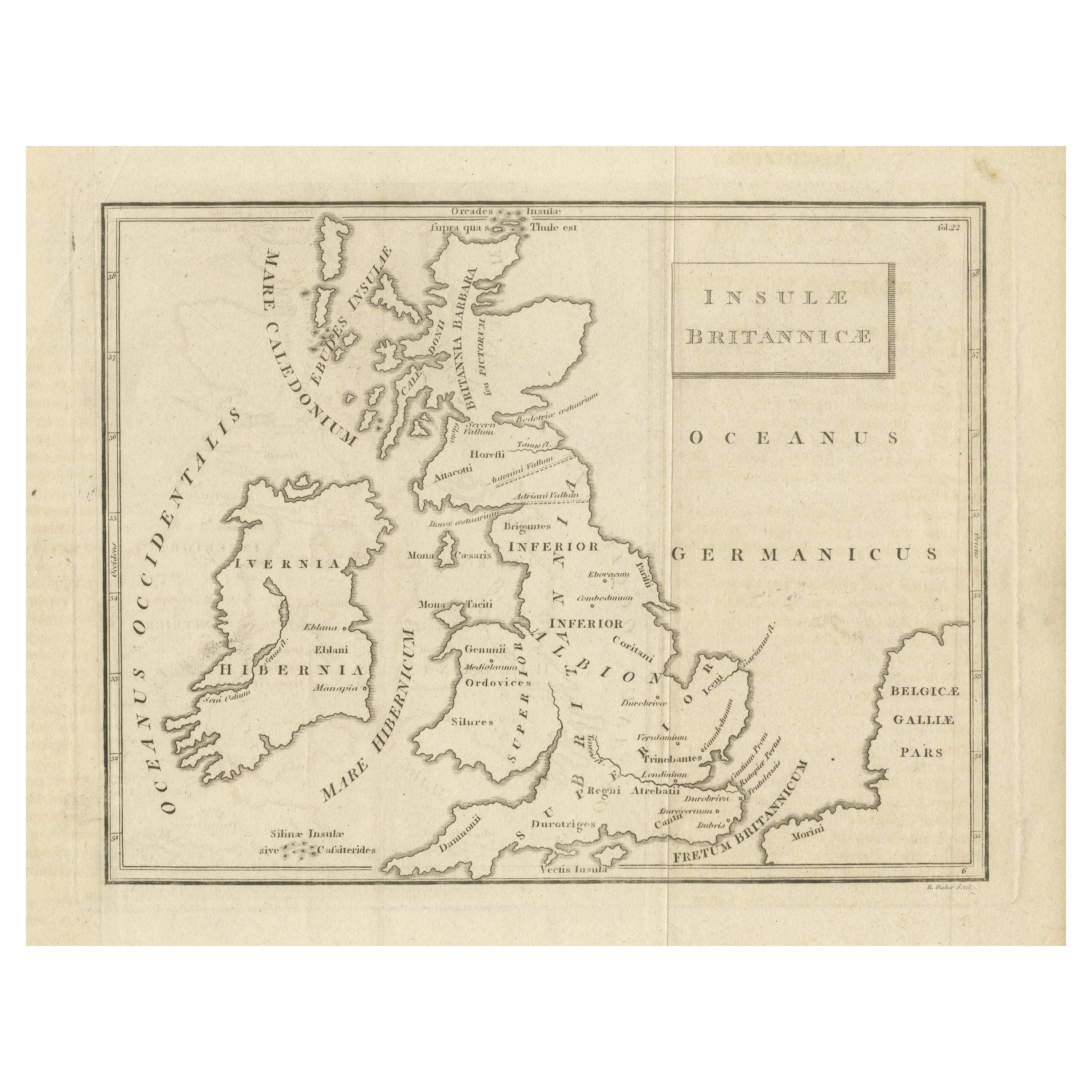
Antique Map of the British Isles According to the Geography of the Roman Empire
Located in Langweer, NL
Antique map titled 'Insulae Britannicae'. Interesting map of Britain, Scotland, and Ireland. It shows a rudimentary outline of the islands according to the geography of the Roman Emp...
Category
Antique Late 18th Century Maps
Materials
Paper
$171 Sale Price
20% Off
You May Also Like
England and the British Isles: A Large 17th Century Hand-colored Map by de Wit
By Frederick de Wit
Located in Alamo, CA
This is a large hand-colored 17th century map of England and the British Isles by Frederick de Wit entitled "Accuratissima Angliæ Regni et Walliæ Principatus", published in Amsterdam in 1680. It is a highly detailed map of England, Scotland, the Scottish Isles...
Category
Late 17th Century Other Art Style Landscape Prints
Materials
Engraving

John Senex (1678-1740) - 18th Century Engraving, A New Map of Great Britain
By John Senex
Located in Corsham, GB
A New Map of Great Britain - Corrected from the Observations Communicated to the Royal Society at London. By John Senex F.R.S. A double-page engraved map on 2 sheets joined, with lat...
Category
18th Century More Prints
Materials
Engraving

Old Horizontal Map of England
By Tasso
Located in Alessandria, Piemonte
ST/520 - Old rare Italian map of England, dated 1826-1827 - by Girolamo Tasso, editor in Venise, for the atlas of M.r Le-Sage.
Category
Antique Early 19th Century Italian Other Prints
Materials
Paper

Large Original Vintage Map of the United Kingdom, circa 1920
Located in St Annes, Lancashire
Great map of The United Kingdom
Unframed
Original color
By John Bartholomew and Co. Edinburgh Geographical Institute
Published, circa 1920
Free shipping.
Category
Vintage 1920s British Maps
Materials
Paper

Map of Lancashire
Located in Cheshire, GB
Saxton Map of Lancashire hand coloured. Encased in an ebonised frame.
Dimensions
Height 21 Inches
Width 24 Inches
Depth 1 Inches
Category
Early 20th Century British Maps
Materials
Paper

$767 Sale Price
20% Off
Great Britain, N. France: A Large 17th C. Hand-colored Map by Sanson and Jaillot
By Nicholas Sanson d'Abbeville
Located in Alamo, CA
This large hand-colored 17th century copperplate engraved map entitled "Le Royaume D Angleterre, distingué en ses Provinces. Par le Sr. Sanson. Geographe du Roy. Presenté A Monseigne...
Category
1690s Landscape Prints
Materials
Engraving

More Ways To Browse
1681 Moses Pitt
Antique Map Bermuda
Antique Map Of Brooklyn
Antique Map Of Republic Of Texas
Extra Large Map
George Weymouth
Georgetown Map
Hemisphere Antiques
J Matthews
Japanese Kite
Maltese Falcon
Map Tuscany
St Eustatius
Sumba Map
Used Furniture Denver Co
Used Furniture Leominster
Vintage Long Island Map
Vintage World Map Desk