Items Similar to Beautiful Map of the Region Naters and Pancrasgors, The Netherlands, ca.1697

Want more images or videos?
Request additional images or videos from the seller
1 of 6
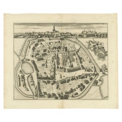
Beautiful Map of the Region Naters and Pancrasgors, The Netherlands, ca.1697
$1,292.95
$1,616.1920% Off
£953.75
£1,192.1920% Off
€1,080
€1,35020% Off
CA$1,791.44
CA$2,239.3120% Off
A$1,943.99
A$2,429.9920% Off
CHF 1,030.14
CHF 1,287.6820% Off
MX$23,842.10
MX$29,802.6320% Off
NOK 12,747.96
NOK 15,934.9520% Off
SEK 12,046.14
SEK 15,057.6820% Off
DKK 8,223.99
DKK 10,279.9920% Off
About the Item
Antique map titled ‘Caarte der Heerlyckheyt van Naters ende Pancras Gors’.
Beautiful map of the region Naters and Pancrasgors, The Netherlands. This map originates from ‘Caert-boeck Voorne’.
Artists and Engravers: A. Steyvaart, I. Stemmers and I. Luyken.
- Dimensions:Height: 20.08 in (51 cm)Width: 28.15 in (71.5 cm)Depth: 0.01 in (0.2 mm)
- Materials and Techniques:
- Period:1690-1699
- Date of Manufacture:circa 1697
- Condition:Repaired: repair on the right. Wear consistent with age and use. Condition: Good. General age-related toning. Repair on the right. Please study image carefully.
- Seller Location:Langweer, NL
- Reference Number:Seller: BG-06803 1stDibs: LU3054326763072
About the Seller
5.0
Recognized Seller
These prestigious sellers are industry leaders and represent the highest echelon for item quality and design.
Platinum Seller
Premium sellers with a 4.7+ rating and 24-hour response times
Established in 2009
1stDibs seller since 2017
2,622 sales on 1stDibs
Typical response time: <1 hour
- ShippingRetrieving quote...Shipping from: Langweer, Netherlands
- Return Policy
Authenticity Guarantee
In the unlikely event there’s an issue with an item’s authenticity, contact us within 1 year for a full refund. DetailsMoney-Back Guarantee
If your item is not as described, is damaged in transit, or does not arrive, contact us within 7 days for a full refund. Details24-Hour Cancellation
You have a 24-hour grace period in which to reconsider your purchase, with no questions asked.Vetted Professional Sellers
Our world-class sellers must adhere to strict standards for service and quality, maintaining the integrity of our listings.Price-Match Guarantee
If you find that a seller listed the same item for a lower price elsewhere, we’ll match it.Trusted Global Delivery
Our best-in-class carrier network provides specialized shipping options worldwide, including custom delivery.More From This Seller
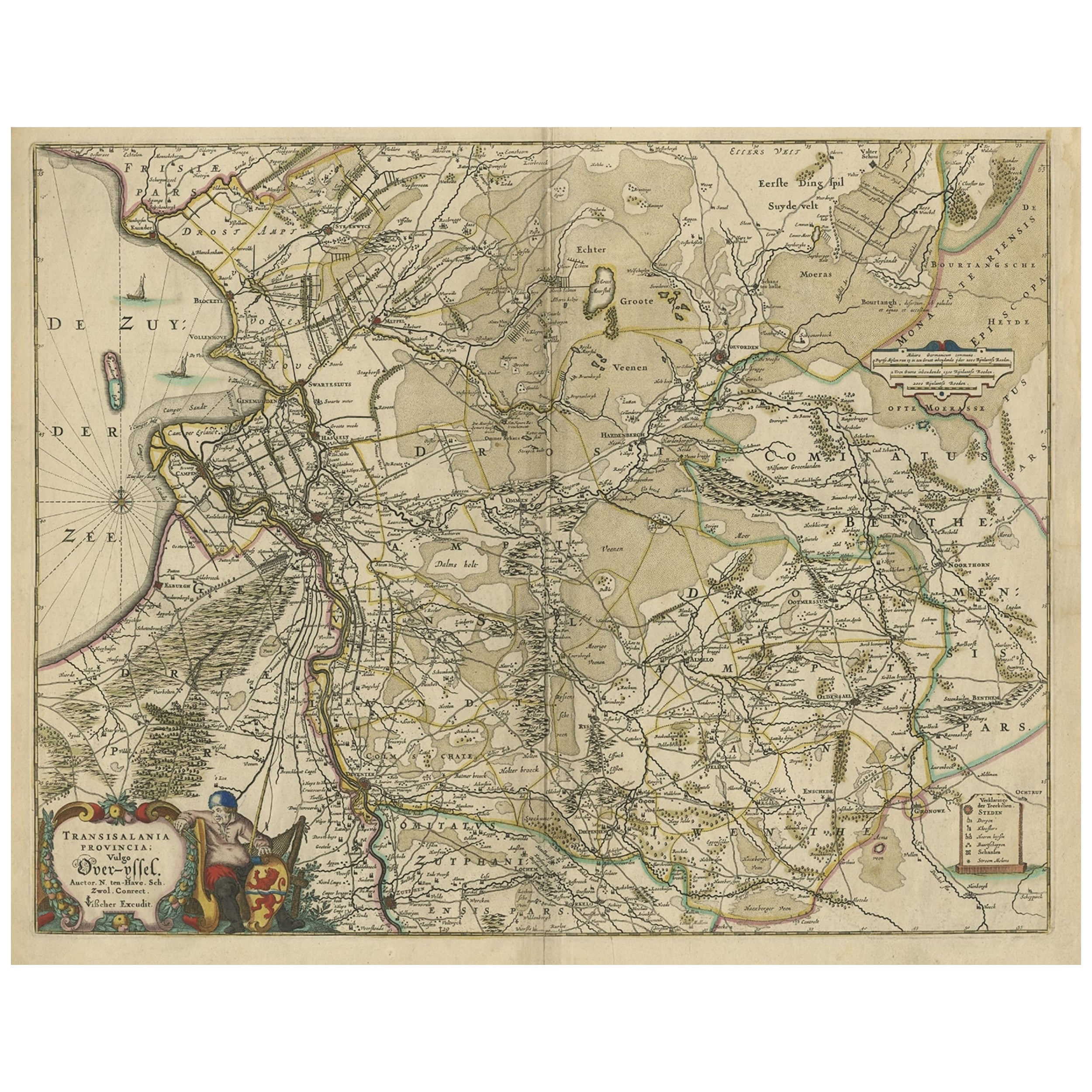
View AllAttractive Original Map of the Province of Overijssel, the Netherlands, Ca.1700
Located in Langweer, NL
Antique print, titled: 'Transisalania Provincia vulgo Over-yssel.'
Attractive original handcoloured map of the province of Overijssel, The Netherlands. With beautiful title cartouc...
Category
Antique Early 1700s Maps
Materials
Paper
$897 Sale Price
40% Off
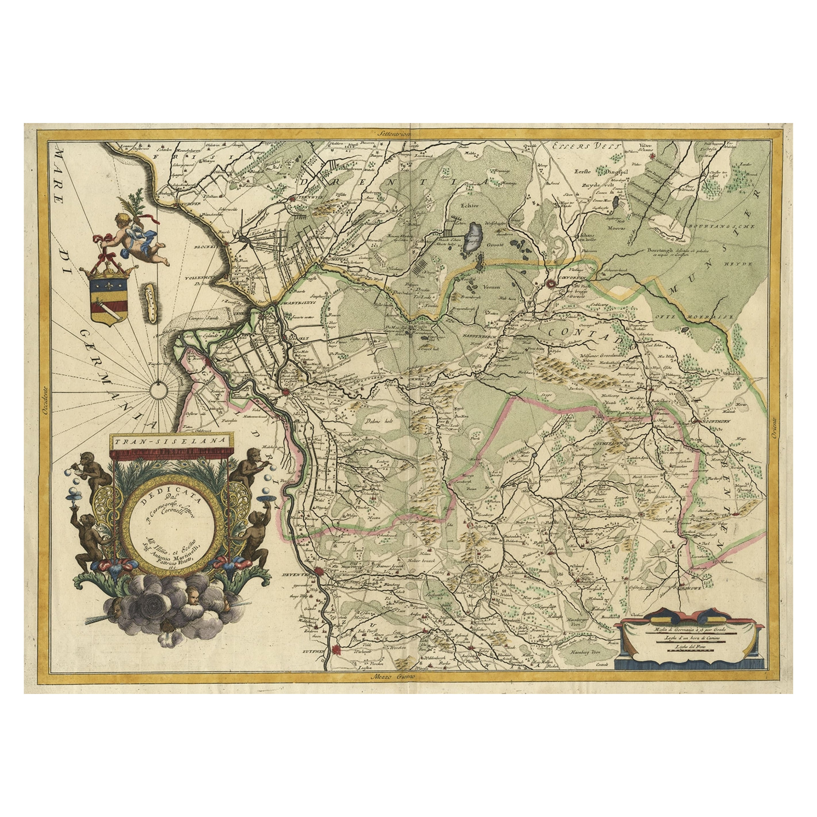
Splendid Detailed Map of the Province of Overijssel in the Netherlands, ca.1692
Located in Langweer, NL
Antique map titled 'Tran-siselana'. Splendid detailed and decorative map of the province of Overijssel in the Netherlands by Vincenzo Coronelli. An elaborate title cartouche garlande...
Category
Antique 1690s Maps
Materials
Paper
$1,464 Sale Price
24% Off
Antique Map of the Netherlands and Belgium by Homann, circa 1710
By Johann Baptist Homann
Located in Langweer, NL
Antique map titled 'Tabula Generalis Totius Belgii Provinciae XVII. Infer. Germaniae (..)'. Map of the Benelux countries by Johann Baptist Homann. Shows the area between the Seine es...
Category
Antique Early 18th Century German Maps
Materials
Paper

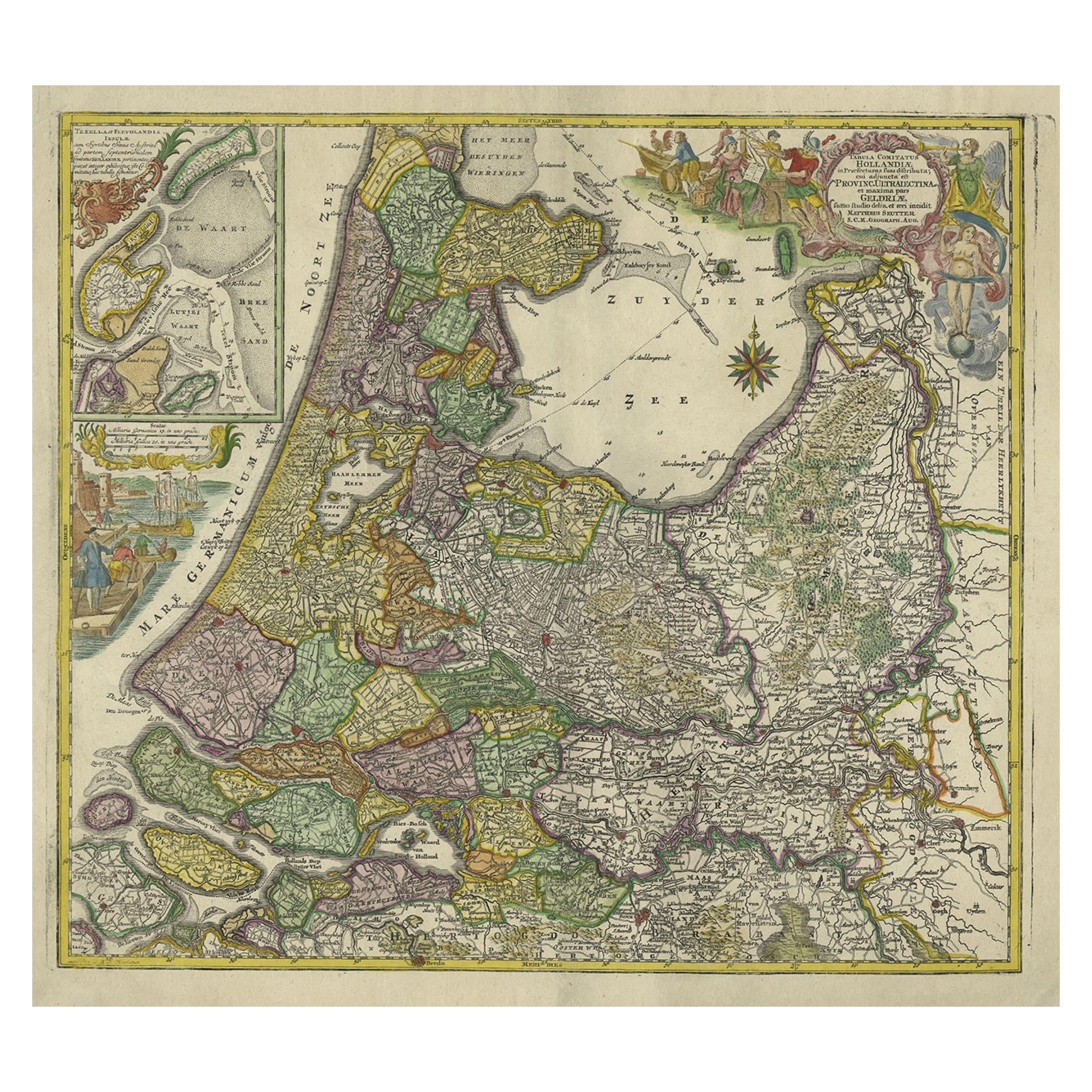
Antique Map of the Northwestern Netherlands, incl Texel and Vlieland, ca.1741
Located in Langweer, NL
Antique print, titled: 'Tabula Comitatus Hollandiae in Praefecturas sua distributa; cui adjuncta est Provinc. Ultraiectina et maxima pars Geldriae summo studio delin. Et aeri incidit...
Category
Antique 1740s German Maps
Materials
Paper
$900 Sale Price
20% Off
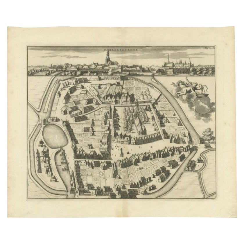
Antique Map of the City of Sint-Maartensdijk by Smallegange, c.1696
Located in Langweer, NL
Antique map titled 'St. Maertensdyk'. Original antique map of the city of Sint-Maartensdijk, the Netherlands. Source unknown, to be determined.
Artists and Engravers: Published b...
Category
Antique 17th Century Maps
Materials
Paper
$158 Sale Price
20% Off
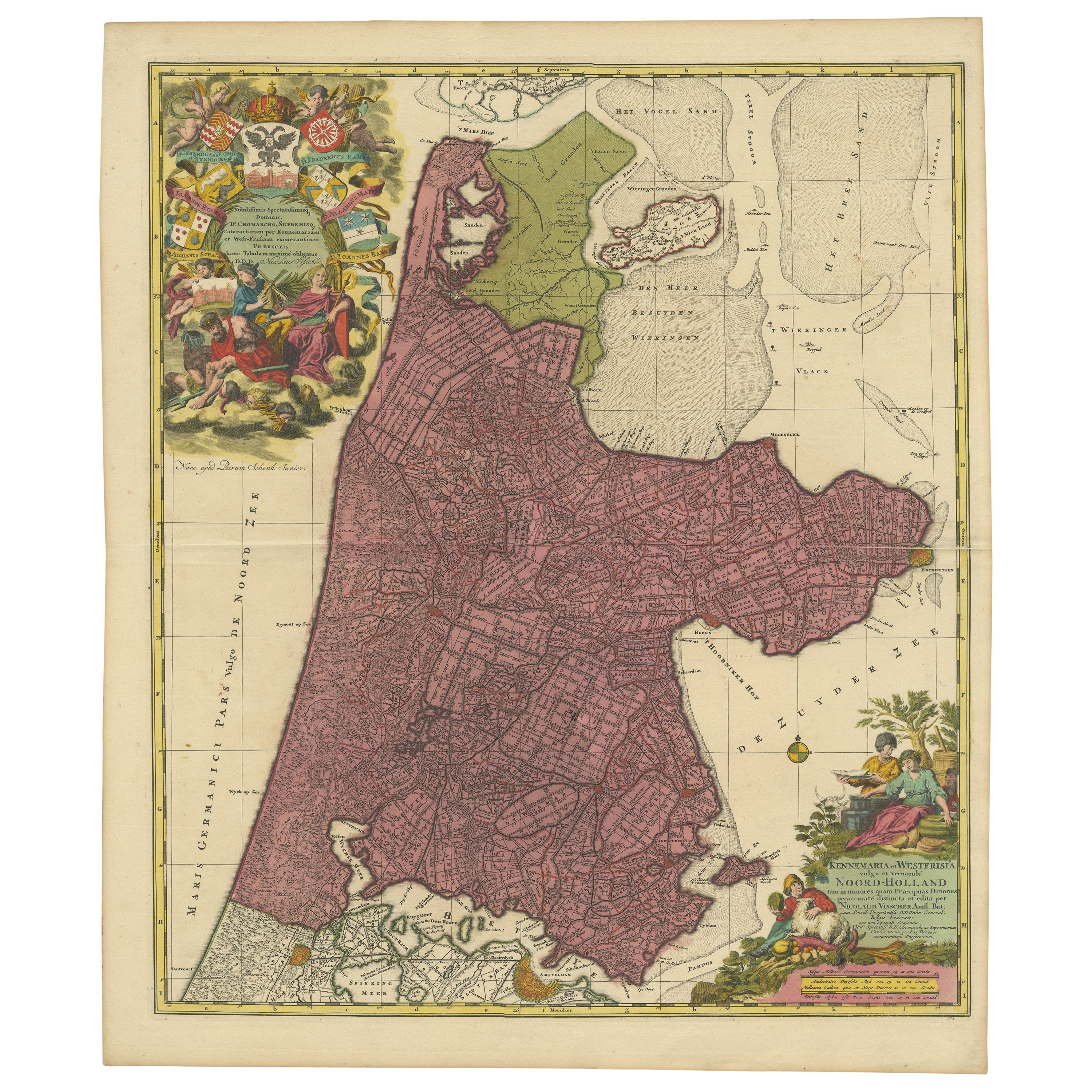
Beautiful Antique Map of the Province of Noord-Holland, the Netherlands, Ca.1730
Located in Langweer, NL
Antique map titled 'Kennemaria et Westfrisia vulgo et vernaculé Noord-Holland'.
Beautiful original antique map of the province of Noord-Holland, the Netherlands. Two large elaborat...
Category
Antique 1730s Maps
Materials
Paper
$1,388 Sale Price
20% Off
You May Also Like
Utrecht, Netherlands: A Large 17th Century Hand-colored Map by Sanson & Jaillot
By Nicholas Sanson d'Abbeville
Located in Alamo, CA
This large hand-colored map entitled "La Seigneurie d'Utrecht. Dressé sur les memoires les plus nouveaux par le Sr. Sanson" was originally created by Nicholas Sanson d'Abbeville. Thi...
Category
1690s Landscape Prints
Materials
Engraving

North Holland, Netherlands: A Large 17th C. Hand-colored Map by Sanson & Jaillot
By Nicholas Sanson d'Abbeville
Located in Alamo, CA
This large hand-colored map entitled "Le Comte De Hollande Dressee sur les Memoires les plus Nouveaux" was originally created by Nicholas Sanson d'Abbeville. This version was publish...
Category
1690s Landscape Prints
Materials
Engraving

1643 Willem&Joan Blaeu Map NW Flanders "Flandriae Teutonicae Pars Prientalior
Located in Norton, MA
1643 Willem and Joan Blaeu map of northwest Flanders, entitled
"Flandriae Teutonicae Pars Prientalior,"
Ric0012
" Authentic" - Map of the northwest Fl...
Category
Antique 17th Century Dutch Maps
Materials
Paper

1752 Vaugoundy Map of Flanders : Belgium, France, and the Netherlands, Ric.a002
Located in Norton, MA
Large Vaugoundy Map of Flanders:
Belgium, France, and the Netherlands
Colored -1752
Ric.a002
Description: This is a 1752 Didier Robert de Vaugondy map of Flanders. The map de...
Category
Antique 17th Century Unknown Maps
Materials
Paper

1635 Willem Blaeu Map of Northern France"Comitatvs Bellovacvm" Ric.a08
Located in Norton, MA
1635 Willem Blaeu map of northern France, entitled.
"Comitatvs Bellovacvm Vernacule Beavvais,"
Colored
Ric.a008
“COMITATVS BELLOVACVM…” Amsterdam: W...
Category
Antique 17th Century Unknown Maps
Materials
Paper

Belgium and the Netherlands: A Hand-colored 17th Century Map by Visscher
By Nicolaus Visscher
Located in Alamo, CA
This is an original hand-colored 17th century map of Belgium by Nicolaus (Nicolas) Visscher II entitled "Belgium Foederatum emendate auctum et novissime editum", published in Amsterdam in 1678. The map shows the seven provinces comprising the Belgium federation or the Republic of the Seven United Netherlands or the Dutch Republic as it was also known. The republic was formed when an alliance of seven Dutch provinces in the Spanish Netherlands revolted against rule by Spain in 1579 (the Union of Utrecht) and declared their independence in 1581 (the Act of Abjuration). The seven provinces were Groningen, Frisia, Overijssel, Guelders, Utrecht, Holland and Zeeland. This was a predecessor state to the Netherlands and the first fully independent Dutch nation state. Amsterdam, Delft, Rouen, Utrecht, Brugge, Ghent, and Antwerp are all included on the map. A small inset map in the lower right depicts the course of the Maas River from Maastricht to Wessem. There is a decorative cartouche in the upper left corner and a distance scale cartouche in the lower right corner.
The map is presented in an attractive antiqued medium brown-colored wood frame with gold-colored inner and outer trim and a light tan-colored fabric mat. The frame measures 26.63" high by 30" wide by 0.75" deep. There is some darkening of the red areas in the map, presumably related to oxidation of the original iron containing pigment over time. There are also a few scattered spots. The map is otherwise in very good condition.
The Visscher family were one of the great cartographic families of the 17th century. Begun by Claes Jansz Visscher...
Category
Late 17th Century Other Art Style Landscape Prints
Materials
Engraving

More Ways To Browse
Antique Map By Coronelli
Cyprus Antique Maps
John Speed Maps
M Howard
Used Office Furniture Michigan
Antique Geological Maps
Antique Manitoba
Australian Colonial
Bengal Map
Stanford Furniture
Tennessee Antique Furniture
Used Furniture Alabama
Used Office Furniture Maine
Ancient World Map
Antique Florida Map
Antique Map Chile
Antique Map Of Georgia
Antique Mississippi Furniture